Narrow Results By
Subject
- Agriculture - Crops 1
- Agriculture - Farms 1
- Buildings - Commercial - Restaurants 2
- Buildings - Heritage 2
- Buildings - Industrial - Factories 10
- Buildings - Religious - Churches 12
- Buildings - Residential 2
- Buildings - Residential - Houses 1
- Buildings - Schools 20
- Businesses - Real Estate Agencies 1
- Documentary Artifacts - Architectural Drawings 19
- Documentary Artifacts - Maps 1
Creator
- Adams, John 2
- Associated Factory Mutual Fire Insurance Cos 1
- Bekins Moving and Storage Company Limited 1
- British Columbia Underwriters' Association 13
- Burnaby Centennial '71 Committee 1
- Burnaby Village Museum 1
- Burnett and McGugan B.C. Land Surveyors, New Westminster 5
- Burnett, David H. 2
- Burnett, Geoffrey K. 6
- Burnett & McGugan, Engineers and Surveyors 25
- Century Park Museum Association 1
- Charles Torrence Limited 1
Person / Organization
- All Saints Anglican Church 1
- Armstrong Avenue School 1
- Barnet School 1
- British Columbia Electric Railway Company 1
- Broadview Presbyterian Church 1
- Brownlee, James Harrison 1
- Burnaby Village Museum 32
- Burnett, Geoffrey K. 2
- Ceperley, H.T. 2
- Chinese Market Gardens 1
- Corsbie, Joseph Hardcastle-Cumberland "Joe" 2
- Dominion Bridge Company 1
![1892 Burnaby Centennial, [1992] thumbnail](/media/hpo/_Data/_BVM_Cartographic_Material/2013/2013_0008_0001_001.jpg?width=280)
1892 Burnaby Centennial
https://search.heritageburnaby.ca/link/museumdescription8704
- Repository
- Burnaby Village Museum
- Date
- [1992]
- Collection/Fonds
- Burnaby Village Museum Map collection
- Description Level
- Item
- Physical Description
- 1 map : blueline print ; 71 cm x 119 cm
- Scope and Content
- A birds eye view map of Burnaby, drawn by Mark Lewis, Parks staff, as a Parks-Maintenance Centennial Project for the 1892 - 1992 Burnaby Centennial. It features wildlife found in Burnaby and highlights civic buildings, parks and other prominent structures of the time. This is not a scale map.
- Repository
- Burnaby Village Museum
- Collection/Fonds
- Burnaby Village Museum Map collection
- Description Level
- Item
- Physical Description
- 1 map : blueline print ; 71 cm x 119 cm
- Material Details
- "1892 BURNABY/ CENTENNIAL 1992" printed in a banner across the top of the map Burnaby Centennial logo is located in the lower right side. "ALL WILDLIFE SHOWN CAN STILL / BE FOUND IN THE BURNABY AREA" printed in lower right corner "DRAWN BY / MARK LEWIS / A PARKS-MAINTENANCE / CENTENNIAL PROJECT" printed in the very lower right corner.
- The map is dark blue ink, there is no colour.
- Scope and Content
- A birds eye view map of Burnaby, drawn by Mark Lewis, Parks staff, as a Parks-Maintenance Centennial Project for the 1892 - 1992 Burnaby Centennial. It features wildlife found in Burnaby and highlights civic buildings, parks and other prominent structures of the time. This is not a scale map.
- History
- Drawn by Mark Lewis of the Parks-Maintenance Dept for the 1882 - 1992 Centennial of Burnaby. Mark always loved birds-eye maps, and showed this map to his supervisors while the work was still in progress. They suggested the map could be a Parks Maintenance Centennial Project. Mark agreed, and completed the map, including Burnaby landmarks and sketches of wildlife. Several copies of the map were given to schools so students could colour them.
- Creator
- Lewis, Mark
- Accession Code
- BV013.8.1
- Access Restriction
- No restrictions
- Reproduction Restriction
- No known restrictions
- Date
- [1992]
- Media Type
- Cartographic Material
- Scan Resolution
- 300
- Scan Date
- 05-Jun-2013
- Scale
- 96
- Notes
- Transcribed title
Images
![1892 Burnaby Centennial, [1992] thumbnail](/media/hpo/_Data/_BVM_Cartographic_Material/2013/2013_0008_0001_001.jpg)
Agreement for sale of land between Joseph C. Armstrong and Jesse Love re District Lot 25
https://search.heritageburnaby.ca/link/museumdescription18788
- Repository
- Burnaby Village Museum
- Date
- 6 Oct. 1893
- Collection/Fonds
- Love family fonds
- Description Level
- Item
- Physical Description
- 1 p. of textual records + 1 plan : red and black ink on linen ; 16 x 8.5 cm
- Scope and Content
- Item consists of an Agreement for Sale of Land dated October 6, 1893 between Joseph C. Armstrong and Jesse Love for District Lot 25, Group one, New Westminster District and a small hand drawn plan showing District Lot 25, Cumberland Road and location of building. Land Agreement was registered Febru…
- Repository
- Burnaby Village Museum
- Collection/Fonds
- Love family fonds
- Description Level
- Item
- Physical Description
- 1 p. of textual records + 1 plan : red and black ink on linen ; 16 x 8.5 cm
- Scope and Content
- Item consists of an Agreement for Sale of Land dated October 6, 1893 between Joseph C. Armstrong and Jesse Love for District Lot 25, Group one, New Westminster District and a small hand drawn plan showing District Lot 25, Cumberland Road and location of building. Land Agreement was registered February 13, 1894.
- Accession Code
- BV992.26.8
- Access Restriction
- No restrictions
- Reproduction Restriction
- No known restrictions
- Date
- 6 Oct. 1893
- Media Type
- Textual Record
- Cartographic Material
- Notes
- Title based on contents of item
- Document dated Oct 6 1893; "ARTICLES OF AGREEMENT" between Joseph C. Armstrong and Jesse Love; one page, folded on buff, legal-sized paper with pink borders; black print; handwritten in faded brown ink; for a parcel of land in the New Westminster District, all that portion of Lot 25, Group I, from a point on the Easterly side 20 chains from the South Easterly corner, then from the South Easterly corner, then northerly and parallel with the Cumberland Road for 10 chains and 52 links, then southerly 10 chains, then Easterly 14 chains and 52 links, total 14 acres and 52/100; for $1161 in 17 instalments at 6% interest; signed by Jesse Love and J.C. Armstrong, witnessed by H.A. Eastman; two seals are missing, pink stains on paper; addition May 1900 signed by Jesse Love and H.A. Eastman; folds twice; when folded, panel showing is "AGREEMENT for Sale of Land." "on Cumberland road in Lot 25 Group I"; handwritten "H.A. Eastman" over printed "E.H. PORT & CO.", "REAL ESTATE BROKERS" "NEW WESTMINSTER BRITISH COLUMBIA"; back panel has blue stamping and pink additions, giving No. 546C, registered February 13, 1894, Charge Book Vol. 13, Folio 51, signed C.S. Corrigan? District Registrar; with hand-drawn plan on stained linen, pink ink with black additions, shows Cumberland Road and city limits.
![All Saints Church, [ca.1910] thumbnail](/media/hpo/_Data/_BVM_Cartographic_Material/2003/2003_0083_0046_001.jpg?width=280)
All Saints Church
https://search.heritageburnaby.ca/link/museumdescription11924
- Repository
- Burnaby Village Museum
- Date
- [ca.1910]
- Collection/Fonds
- Ronald G. Scobbie collection
- Description Level
- Item
- Physical Description
- 1 plan : black ink and watercol. on paper ; 30.45 x 30.5 cm
- Scope and Content
- Item consists of building insurance plan of "All Saints Church / Lot "A" BK 29 DL 98 GP1 N.W.D.". Watling Street is idenfied to the north of the church building and Royal Oak Avenue to the west.
- Repository
- Burnaby Village Museum
- Collection/Fonds
- Ronald G. Scobbie collection
- Description Level
- Item
- Physical Description
- 1 plan : black ink and watercol. on paper ; 30.45 x 30.5 cm
- Material Details
- Scale 1 inch = 20 feet
- Scope and Content
- Item consists of building insurance plan of "All Saints Church / Lot "A" BK 29 DL 98 GP1 N.W.D.". Watling Street is idenfied to the north of the church building and Royal Oak Avenue to the west.
- Subjects
- Buildings - Religious - Churches
- Accession Code
- BV003.83.46
- Access Restriction
- No restrictions
- Reproduction Restriction
- No known restrictions
- Date
- [ca.1910]
- Media Type
- Cartographic Material
- Scan Resolution
- 600
- Scan Date
- 15-Jan-2021
- Scale
- 100
- Notes
- Transcribed title
- Note in pencil on verso reads: ""All Saints Church / Lot "A" BK 29 DL 98 / Scale 1 inch = 20 feet"
- Note in balck in on verso reads: "3704"
Images
![All Saints Church, [ca.1910] thumbnail](/media/hpo/_Data/_BVM_Cartographic_Material/2003/2003_0083_0046_001.jpg)
![Anglican Church, [ca.1910] thumbnail](/media/hpo/_Data/_BVM_Cartographic_Material/2003/2003_0083_0043_001.jpg?width=280)
Anglican Church
https://search.heritageburnaby.ca/link/museumdescription11921
- Repository
- Burnaby Village Museum
- Date
- [ca.1910]
- Collection/Fonds
- Ronald G. Scobbie collection
- Description Level
- Item
- Physical Description
- 1 plan : black ink and watercol. on paper ; 30.45 x 30.5 cm
- Scope and Content
- Item consists of building insurance plan of "Anglican Church / Lot 2 BK 37 DL69, GP.1, N.W.D. (15th Ave. (Dominion) is identified to the north of Lots 1, 2 and 3).
- Repository
- Burnaby Village Museum
- Collection/Fonds
- Ronald G. Scobbie collection
- Description Level
- Item
- Physical Description
- 1 plan : black ink and watercol. on paper ; 30.45 x 30.5 cm
- Material Details
- Scale 1 inch = 20 feet
- Scope and Content
- Item consists of building insurance plan of "Anglican Church / Lot 2 BK 37 DL69, GP.1, N.W.D. (15th Ave. (Dominion) is identified to the north of Lots 1, 2 and 3).
- Subjects
- Buildings - Religious - Churches
- Accession Code
- BV003.83.43
- Access Restriction
- No restrictions
- Reproduction Restriction
- No known restrictions
- Date
- [ca.1910]
- Media Type
- Cartographic Material
- Scan Resolution
- 600
- Scan Date
- 15-Jan-2021
- Scale
- 100
- Notes
- Transcribed title
- Note in pencil on verso reads: "Anglican Church / Lot 2 Bk 37 DL69 / 1"=20' "
- Note in balck in on verso reads: "3704"
Images
![Anglican Church, [ca.1910] thumbnail](/media/hpo/_Data/_BVM_Cartographic_Material/2003/2003_0083_0043_001.jpg)
Architectural plan - A-1 Project No. 73-0031
https://search.heritageburnaby.ca/link/museumdescription15069
- Repository
- Burnaby Village Museum
- Date
- 1973
- Collection/Fonds
- Elmer Wilson Martin fonds
- Description Level
- Item
- Physical Description
- 1 architectural drawing : blueline print ; 55.5 x 91.5 cm
- Scope and Content
- Item consists of architectural plan, sheet No. A-1 Project No. 73-0031 created by Structures Inc. Cincinnati, Ohio. This plan model was manufactured and sold under patents held by E.W. Martin of Burnaby who designed the paneloc building.
- Repository
- Burnaby Village Museum
- Collection/Fonds
- Elmer Wilson Martin fonds
- Description Level
- Item
- Physical Description
- 1 architectural drawing : blueline print ; 55.5 x 91.5 cm
- Material Details
- Scales differ between 1/4" = 1'-0" and 3" = 1'-0"
- Scope and Content
- Item consists of architectural plan, sheet No. A-1 Project No. 73-0031 created by Structures Inc. Cincinnati, Ohio. This plan model was manufactured and sold under patents held by E.W. Martin of Burnaby who designed the paneloc building.
- Creator
- Structures Incorporated
- Responsibility
- Paneloc Marketing Limited
- Accession Code
- BV019.40.14
- Access Restriction
- No restrictions
- Reproduction Restriction
- May be restricted by third party rights
- Date
- 1973
- Media Type
- Architectural Drawing
- Notes
- Title based on contents of drawing
- Note in red ink at bottom of drawing reads: "PRELIMINARY - NOT FOR CONSTRUCTION"
- Stamp in black ink reads: "Proprietary Notice / This is an unpublished manuscript which is revealed / in confidence. This drawing and information contained / herein is the trade secret of Structures Inc. / The possession of this material/drawing confers no / license or right to produce the product or to re- /produce, transmit or reveal in oral or written form / what is depicted therein without written permission / of Structures Inc."
Architectural plan - A-2 Project No. 73-0032
https://search.heritageburnaby.ca/link/museumdescription15070
- Repository
- Burnaby Village Museum
- Date
- 1973
- Collection/Fonds
- Elmer Wilson Martin fonds
- Description Level
- Item
- Physical Description
- 1 architectural drawing : blueline print ; 55.5 x 91.5 cm
- Scope and Content
- Item consists of architectural plan, sheet No. A-2 Project No. 73-0032 created by Structures Inc. Cincinnati, Ohio. This plan model was manufactured and sold under patents held by E.W. Martin of Burnaby who designed the paneloc building.
- Repository
- Burnaby Village Museum
- Collection/Fonds
- Elmer Wilson Martin fonds
- Description Level
- Item
- Physical Description
- 1 architectural drawing : blueline print ; 55.5 x 91.5 cm
- Material Details
- Scales 11/2"=1'-0" and 3/8"=1'-0"
- Scope and Content
- Item consists of architectural plan, sheet No. A-2 Project No. 73-0032 created by Structures Inc. Cincinnati, Ohio. This plan model was manufactured and sold under patents held by E.W. Martin of Burnaby who designed the paneloc building.
- Creator
- Structures Incorporated
- Responsibility
- Paneloc Marketing Limited
- Accession Code
- BV019.40.15
- Access Restriction
- No restrictions
- Reproduction Restriction
- May be restricted by third party rights
- Date
- 1973
- Media Type
- Architectural Drawing
- Notes
- Title based on contents of drawing
- Stamp in black ink reads: "Proprietary Notice / This is an unpublished manuscript which is revealed / in confidence. This drawing and information contained / herein is the trade secret of Structures Inc. / The possession of this material/drawing confers no / license or right to produce the product or to re- /produce, transmit or reveal in oral or written form / what is depicted therein without written permission / of Structures Inc."

Armstrong Street School site
https://search.heritageburnaby.ca/link/museumdescription11133
- Repository
- Burnaby Village Museum
- Date
- 1915
- Collection/Fonds
- Ronald G. Scobbie collection
- Description Level
- Item
- Physical Description
- 1 survey plan : blueprint on paper ; 56 x 54 cm
- Scope and Content
- Survey plan of "Armstrong Street School Site / Burnaby Municipality" "Being a 2 acre portion of Lot 13 Group 1, & according to map 1722 which shows this as Lot E. Block 2 of subdivision of a portion, of Lot 13, Group 1, New Westminster District".
- Repository
- Burnaby Village Museum
- Collection/Fonds
- Ronald G. Scobbie collection
- Description Level
- Item
- Physical Description
- 1 survey plan : blueprint on paper ; 56 x 54 cm
- Material Details
- Scale 40 feet = 1 inch
- Scope and Content
- Survey plan of "Armstrong Street School Site / Burnaby Municipality" "Being a 2 acre portion of Lot 13 Group 1, & according to map 1722 which shows this as Lot E. Block 2 of subdivision of a portion, of Lot 13, Group 1, New Westminster District".
- Creator
- Burnett, Geoffrey K.
- Subjects
- Buildings - Schools
- Names
- Armstrong Avenue School
- Responsibility
- Burnett & McGugan, Engineers and Surveyors
- Geographic Access
- Armstrong Avenue
- Street Address
- 8757 Armstrong Avenue
- Accession Code
- BV003.83.12
- Access Restriction
- No restrictions
- Reproduction Restriction
- No known restrictions
- Date
- 1915
- Media Type
- Cartographic Material
- Historic Neighbourhood
- East Burnaby (Historic Neighbourhood)
- Planning Study Area
- Cariboo-Armstrong Area
- Scan Resolution
- 440
- Scan Date
- 22-Dec-2020
- Scale
- 100
- Notes
- Title based on contents of plan
- Note in black ink on verso of plan reads: "1746"
- Oath on plan reads: "I, Geoffrey K. Burnett...and did personally superintend the survey represented..." "Completed on the 18th day of March 1915"; signed by Geoffrey K. Burnett and notarized by "K.A. Eastman", sworn "...19th day of April 1915"; "Burnett and McGugan., B.C. Land Surveyors. Etc.. New Westminster, B.C.."
Zoomable Images


Barnet School site
https://search.heritageburnaby.ca/link/museumdescription11140
- Repository
- Burnaby Village Museum
- Date
- May 27, 1915
- Collection/Fonds
- Ronald G. Scobbie collection
- Description Level
- Item
- Physical Description
- 1 survey plan : blueprint on paper ; 56 x 54 cm
- Scope and Content
- Survey plan of "Barnet School Site / Burnaby Municipality" "Being a portion of the west half of lot / 214, Group 1 / New Westminster District”.
- Repository
- Burnaby Village Museum
- Collection/Fonds
- Ronald G. Scobbie collection
- Description Level
- Item
- Physical Description
- 1 survey plan : blueprint on paper ; 56 x 54 cm
- Material Details
- Scale 40 feet = 1 inch
- Scope and Content
- Survey plan of "Barnet School Site / Burnaby Municipality" "Being a portion of the west half of lot / 214, Group 1 / New Westminster District”.
- Creator
- McGugan, Donald Johnston
- Subjects
- Buildings - Schools
- Names
- Barnet School
- Responsibility
- Burnett & McGugan, Engineers and Surveyors
- Geographic Access
- Barnet Road
- Street Address
- 7820 Barnet Road
- Accession Code
- BV003.83.19
- Access Restriction
- No restrictions
- Reproduction Restriction
- No known restrictions
- Date
- May 27, 1915
- Media Type
- Cartographic Material
- Historic Neighbourhood
- Barnet (Historic Neighbourhood)
- Planning Study Area
- Burnaby Mountain Area
- Scan Resolution
- 440
- Scan Date
- 22-Dec-2020
- Scale
- 100
- Notes
- Title based on contents of plan
- handwritten on back "Burnaby Schools" "23R" twice, "1783"
- Oath on plan reads: "I, D.J. McGugan...and did personally superintend the survey..." "completed on the 27th day of May 1915"; signed by D.J. McGugan, notarized by "Walter Edmonds" "sworn "...29th day of May 1915" "Burnett and McGugan" "B.C. Land Surveyors Etc. New Westminster, B.C.";
Zoomable Images

Bell's Dry Goods exhibit collection series
https://search.heritageburnaby.ca/link/museumdescription16990
- Repository
- Burnaby Village Museum
- Date
- 1974-2012, predominant 1974-1996
- Collection/Fonds
- Burnaby Village Museum fonds
- Description Level
- Series
- Physical Description
- 129 photographs + 10 cm of textual records + approx. 6 architectural drawings + 1 video recording
- Scope and Content
- Series consists of records pertaining to the moving, restoration, exhibit and repair of the Bell's Dry Goods store and Whitechurch Hardware store building that was relocated from Sixth Avenue to Heritage Village (Burnaby Village Museum) in 1974. The building was set up as a permanent exhibit on sit…
- Repository
- Burnaby Village Museum
- Collection/Fonds
- Burnaby Village Museum fonds
- Description Level
- Series
- Physical Description
- 129 photographs + 10 cm of textual records + approx. 6 architectural drawings + 1 video recording
- Scope and Content
- Series consists of records pertaining to the moving, restoration, exhibit and repair of the Bell's Dry Goods store and Whitechurch Hardware store building that was relocated from Sixth Avenue to Heritage Village (Burnaby Village Museum) in 1974. The building was set up as a permanent exhibit on site at Burnaby Village Museum. The majority of the records were created by museum and City of Burnaby staff. Series is arranged into four subseries: 1) Restoration, upgrades and repairs subseries 2) Bell's building photographs subseries 3) Bell's exhibit photographs subseries 4) Bell's research files subseries
- History
- The Bell's Dry Goods building was built in 1922 by Clifford Tuckey with a small lean to structure on the back housing a kitchen and bedroom. The building was located on the northwest corner of Sixth Street and Thirteenth Avenue in Burnaby. William Bell (1884-1952) and Flora Bell (nee Connell) (1889-1953) immigrated to Burnaby from Scotland between 1917 and 1918. In about 1924, the building was purchased by William and Flora Bell. Flora operated "Bell's Dry Goods" store out of the building and the couple lived at the back of the store. William worked as a driver for a local lumber mill. Bell's Dry Goods was in operation in this one storey building between 1925 and 1937 with the building address, 1314 Sixth Street (later 7695 Sixth Street). In 1927, they moved to a house located on Thirteenth Avenue while they converted the back of the store to include the East Burnaby Post Office. In 1937, the Bells moved the one storey "Bell's Dry Goods" building a little further north and built a two storey building on the corner. Flora continued to operate Bell's Dry Goods on the ground level of the new building until 1941 and the couple lived upstairs. The new two storey building assumed the address of 1314 Sixth Street (later 7695 Sixth Street) and the older one storey building obtained a new address of 1316 Sixth Street (later 7685 Sixth Street). The East Burnaby Post Office continued to operate at 1314 Sixth Street until about 1954. On December 1, 1937, Maurice Whitechurch moved his Whitechurch Hardware store into the one storey building which he rented out from the Bells. In 1943, Maurice Whitechurch purchased the building from the Bells and Whitechurch Hardware store continued to operated at this location until the Spring of 1973. In June 1973, Mr. Fergie Will bought the store and the building was donated to Heritage Village (Burnaby Village Museum). In August 1974, the building was relocated from it's location on Sixth Avenue to Heritage Village. Sometime prior to the move, the extension at the rear of the building was removed. After the building was moved to Heritage Village, some exterior repairs were completed including the installation of exterior siding at the rear of the building and installation of large wood sliding door. The building opened as a carpentry shop exhibit in 1975. In March 1976, an extension at the rear of the building was rebuilt by museum staff. The building underwent several repairs and restorations between 1992 and 1996 and was closed to the public. Due to structural problems, the extension was demolished in 1992. Between 1993 and 1996, the building underwent a series of exterior and interior structural repairs to restore it to Bell's Dry Goods store which included the rebuilding of the extension at the rear of the building and the moving of the building onto a new foundation. The newly restored building opened as Bell's Dry Goods store (exhibit) on August 6, 1996. On November 23, 1992, the building was designated a heritage building under Heritage Designation Bylaw 1992, Bylaw Number 9807.
- Accession Code
- BV019.52
- BV020.5
- Date
- 1974-2012, predominant 1974-1996
- Media Type
- Photograph
- Textual Record
- Architectural Drawing
- Notes
- Title based on contents of series
- Further accruals are expected
- Some records within this collection are subject to FIPPA
- For other records and photographs associated with this building, see also Century Park Museum Association fonds and Burnaby Village Museum fonds and Jesse Love farmhouse fonds
Bell's restoration, upgrades and repairs subseries
https://search.heritageburnaby.ca/link/museumdescription17002
- Repository
- Burnaby Village Museum
- Date
- 1973-2012
- Collection/Fonds
- Burnaby Village Museum fonds
- Description Level
- Subseries
- Physical Description
- 10 cm of textual records + approx. 6 architectural drawings
- Scope and Content
- Subseries consists of correspondence, reports, tenders, workplans and budget information regarding the moving, restoration, repairs and upgrades to the Whitechurch Hardware - Bell's Dry Goods building on exhibit at Burnaby Village Museum.
- Repository
- Burnaby Village Museum
- Collection/Fonds
- Burnaby Village Museum fonds
- Description Level
- Subseries
- Physical Description
- 10 cm of textual records + approx. 6 architectural drawings
- Scope and Content
- Subseries consists of correspondence, reports, tenders, workplans and budget information regarding the moving, restoration, repairs and upgrades to the Whitechurch Hardware - Bell's Dry Goods building on exhibit at Burnaby Village Museum.
- Names
- Burnaby Village Museum
- Accession Code
- BV020.5
- Access Restriction
- Subject to FIPPA
- Reproduction Restriction
- Reproductions subject to FIPPA
- Date
- 1973-2012
- Media Type
- Textual Record
- Architectural Drawing
- Notes
- Title based on content of subseries
![Bird's eye view of New Westminster, Burnaby and Vancouver, [ca. 1911] thumbnail](/media/hpo/_Data/_BVM_Cartographic_Material/1983/1983_0012_0001_002%20Web.jpg?width=280)
Bird's eye view of New Westminster, Burnaby and Vancouver
https://search.heritageburnaby.ca/link/museumdescription8199
- Repository
- Burnaby Village Museum
- Date
- [ca. 1911]
- Collection/Fonds
- Burnaby Village Museum Map collection
- Description Level
- Item
- Physical Description
- 1 map : hand painted ; 65.5 x 99 cm
- Scope and Content
- An untitled monochromatic grayscale map of a developer's bird's eye view looking north west from Burnaby Mountain. View includes Burnaby, New Westminster, Vancouver with the North shore in the distance. Burnaby neighbourhood subdivisions of "Burnaby Heights" and "Buena Vista" are featured near the…
- Repository
- Burnaby Village Museum
- Collection/Fonds
- Burnaby Village Museum Map collection
- Description Level
- Item
- Physical Description
- 1 map : hand painted ; 65.5 x 99 cm
- Scope and Content
- An untitled monochromatic grayscale map of a developer's bird's eye view looking north west from Burnaby Mountain. View includes Burnaby, New Westminster, Vancouver with the North shore in the distance. Burnaby neighbourhood subdivisions of "Burnaby Heights" and "Buena Vista" are featured near the centre of the map. These neighbourhood subdivisions were marketed by Real Estate Agents Liebly & Blumer in 1911. Roads, buildings, factories, railways and bridges are identified on the map.
- Subjects
- Businesses - Real Estate Agencies
- Responsibility
- Leibly & Blumer Realty Co. Incorporated
- Accession Code
- HV983.12.1
- Access Restriction
- No restrictions
- Reproduction Restriction
- No known restrictions
- Date
- [ca. 1911]
- Media Type
- Cartographic Material
- Historic Neighbourhood
- East Burnaby (Historic Neighbourhood)
- Vancouver Heights (Historic Neighbourhood)
- Planning Study Area
- Cariboo-Armstrong Area
- Burnaby Heights Area
- Scan Resolution
- 300
- Scan Date
- December 2020
- Scale
- 100
- Notes
- Title based on contents of map
- Note in pencil on verso of photograph reads: "Make tint block of Buena Vista / Blocks only as shown in lots"
Zoomable Images
![Bird's eye view of New Westminster, Burnaby and Vancouver, [ca. 1911] thumbnail](/media/hpo/_Data/_BVM_Cartographic_Material/1983/1983_0012_0001_001_seadragon/1983_0012_0001_001.jpg?w=280)

Bird's Eye View of the Burnaby Lake Area
https://search.heritageburnaby.ca/link/museumdescription15144
- Repository
- Burnaby Village Museum
- Date
- 1977
- Collection/Fonds
- Century Park Museum Association fonds
- Description Level
- Item
- Physical Description
- 1 map : b&w print on paper ; 43 x 63.5 cm
- Scope and Content
- Item consists of a map titled "Birds Eye View of the Burnaby Lake Area Circa 1910". The overview of the Burnaby Lake area was compiled and drawn at Heritage Village by curator John Adams and artist, Carol Swan. The map identifies the Burnaby Lake inter-urban tram line; roads including: Sperling Ave…
- Repository
- Burnaby Village Museum
- Collection/Fonds
- Century Park Museum Association fonds
- Description Level
- Item
- Physical Description
- 1 map : b&w print on paper ; 43 x 63.5 cm
- Material Details
- Scale indeterminable
- Scope and Content
- Item consists of a map titled "Birds Eye View of the Burnaby Lake Area Circa 1910". The overview of the Burnaby Lake area was compiled and drawn at Heritage Village by curator John Adams and artist, Carol Swan. The map identifies the Burnaby Lake inter-urban tram line; roads including: Sperling Avenue (Pole Line Road); Gilpin Avenue; Douglas Road; trail to Vancouver Westminster Road (Kingsway); Buckingham Avenue; Haszard Street; various farms and residences including: Charles Sprott "Norland"; H.T. Ceperley "Fairacres"; Claude Hill's "Brookfield farm" and "Broadview"; F.J. Hart's "Avalon"; Miss Woodward's former and new home, school and post office; Councillor Edgar's hunting cabin; Edgar Sprott's "Mayfield farm" and "Mayfield Lodge"; F.J. Peers "Greyfriars"; Arthur de Windt Haszard; Bernard Hill's boathouse as well as other landmarks including: Doran's Mill; tram stations; Burnaby Lake Store; logging camps; wood cutter's shacks; ice houses; cranberry bog; Still Creek; Deer Lake; Burnaby Lake; Deer Lake Creek; Provincial Government Reserve Proposed Hospital (later Oakalla Prison).
- Creator
- Adams, John
- Swan, Carol
- Names
- Hill, Arthur Claude
- Sprott, Charles Frederick
- Sprott, Louis "Edgar"
- Hart, Frederick John, 1884-1945
- Ceperley, H.T.
- Woodward, Maude
- Woodward, Harriet
- Peers, Francis J.
- Haszard, Arthur de Windt
- Hill, Bernard R.
- Geographic Access
- Deer Lake Avenue
- Sperling Avenue
- Haszard Street
- Buckingham Avenue
- Accession Code
- BV021.1.3
- Access Restriction
- No restrictions
- Reproduction Restriction
- No known restrictions
- Date
- 1977
- Media Type
- Cartographic Material
- Historic Neighbourhood
- Burnaby Lake (Historic Neighbourhood)
- Planning Study Area
- Burnaby Lake Area
- Related Material
- See also: Life with the Moores of Hart House : pioneer days on Burnaby's Deer Lake
- Scan Resolution
- 600
- Scan Date
- 2021-11-12
- Scale
- 100
- Notes
- Transcribed title
- Compiled by John Adams; illustration by Carol Swan
- The map depicts the Burnaby Lake Tram Line as being double tracked, whereas in reality it was single tracked.
- Map is part of the book "Life with the Moores of Hart House : pioneer days on Burnaby's Deer Lake https://search.heritageburnaby.ca/permalink/museumlibrary6314-102
Images


Bird's Eye View of the Burnaby Lake Area
https://search.heritageburnaby.ca/link/museumdescription17543
- Repository
- Burnaby Village Museum
- Date
- 1977
- Collection/Fonds
- Century Park Museum Association fonds
- Description Level
- Item
- Physical Description
- 1 map : b&w print with watercolour ; 43 x 63.5 cm
- Scope and Content
- Item consists of a map titled "Birds Eye View of the Burnaby Lake Area Circa 1910". The overview of the Burnaby Lake area was compiled and drawn at Heritage Village by curator John Adams and artist, Carol Swan. The map identifies the Burnaby Lake inter-urban tram line; roads including: Sperling Ave…
- Repository
- Burnaby Village Museum
- Collection/Fonds
- Century Park Museum Association fonds
- Description Level
- Item
- Physical Description
- 1 map : b&w print with watercolour ; 43 x 63.5 cm
- Material Details
- Scale indeterminable
- Scope and Content
- Item consists of a map titled "Birds Eye View of the Burnaby Lake Area Circa 1910". The overview of the Burnaby Lake area was compiled and drawn at Heritage Village by curator John Adams and artist, Carol Swan. The map identifies the Burnaby Lake inter-urban tram line; roads including: Sperling Avenue (Pole Line Road); Gilpin Avenue; Douglas Road; trail to Vancouver Westminster Road (Kingsway); Buckingham Avenue; Haszard Street; various farms and residences including: Charles Sprott "Norland"; H.T. Ceperley "Fairacres"; Claude Hill's "Brookfield farm" and "Broadview"; F.J. Hart's "Avalon"; Miss Woodward's former and new home, school and post office; Councillor Edgar's hunting cabin; Edgar Sprott's "Mayfield farm" and "Mayfield Lodge"; F.J. Peers "Greyfriars"; Arthur de Windt Haszard; Bernard Hill's boathouse as well as other landmarks including: Doran's Mill; tram stations; Burnaby Lake Store; logging camps; wood cutter's shacks; ice houses; cranberry bog; Still Creek; Deer Lake; Burnaby Lake; Deer Lake Creek; Provincial Government Reserve Proposed Hospital (later Oakalla Prison).
- Creator
- Adams, John
- Swan, Carol
- Names
- Hill, Arthur Claude
- Sprott, Charles Frederick
- Sprott, Louis "Edgar"
- Hart, Frederick John, 1884-1945
- Ceperley, H.T.
- Woodward, Maude
- Woodward, Harriet
- Peers, Francis J.
- Haszard, Arthur de Windt
- Hill, Bernard R.
- Geographic Access
- Deer Lake Avenue
- Sperling Avenue
- Haszard Street
- Buckingham Avenue
- Accession Code
- BV021.1.4
- Access Restriction
- No restrictions
- Reproduction Restriction
- No known restrictions
- Date
- 1977
- Media Type
- Cartographic Material
- Historic Neighbourhood
- Burnaby Lake (Historic Neighbourhood)
- Planning Study Area
- Burnaby Lake Area
- Related Material
- See also: Life with the Moores of Hart House : pioneer days on Burnaby's Deer Lake
- Scan Resolution
- 600
- Scan Date
- 2021-11-12
- Scale
- 100
- Notes
- Transcribed title
- Compiled by John Adams; illustration by Carol Swan
- The map depicts the Burnaby Lake Tram Line as being double tracked, whereas in reality it was single tracked.
- Map is part of the book "Life with the Moores of Hart House : pioneer days on Burnaby's Deer Lake https://search.heritageburnaby.ca/permalink/museumlibrary6314-102
- This is a print made from original illustration and appears to be hand-coloured with watercolour at a later date.
Images

![Broadview Presbyterian Church, [ca.1910] thumbnail](/media/hpo/_Data/_BVM_Cartographic_Material/2003/2003_0083_0049_001.jpg?width=280)
Broadview Presbyterian Church
https://search.heritageburnaby.ca/link/museumdescription11927
- Repository
- Burnaby Village Museum
- Date
- [ca.1910]
- Collection/Fonds
- Ronald G. Scobbie collection
- Description Level
- Item
- Physical Description
- 1 plan : black ink and watercol. on paper ; 30.45 x 30.5 cm
- Scope and Content
- Item consists of building insurance plan of "Broadview Presbyterian Church / Lot 6, BK 31, DL 69 / GP1 N.W.D." . Fourteenth Avenue (Manor) is identified to the north and Douglas Ave. to the east.
- Repository
- Burnaby Village Museum
- Collection/Fonds
- Ronald G. Scobbie collection
- Description Level
- Item
- Physical Description
- 1 plan : black ink and watercol. on paper ; 30.45 x 30.5 cm
- Material Details
- Scale 1 inch = 20 feet
- Scope and Content
- Item consists of building insurance plan of "Broadview Presbyterian Church / Lot 6, BK 31, DL 69 / GP1 N.W.D." . Fourteenth Avenue (Manor) is identified to the north and Douglas Ave. to the east.
- Subjects
- Buildings - Religious - Churches
- Accession Code
- BV003.83.49
- Access Restriction
- No restrictions
- Reproduction Restriction
- No known restrictions
- Date
- [ca.1910]
- Media Type
- Cartographic Material
- Scan Resolution
- 600
- Scan Date
- 15-Jan-2021
- Scale
- 100
- Notes
- Transcribed title
- Note in pencil on verso reads: "Broadview Presbyterian Church / Lot 6, BK 31, DL 69 / 1" = 20' "
- Note in balck in on verso reads: "3704"
Images
![Broadview Presbyterian Church, [ca.1910] thumbnail](/media/hpo/_Data/_BVM_Cartographic_Material/2003/2003_0083_0049_001.jpg)
![Building plan, [c. 1900] thumbnail](/media/hpo/_Data/_BVM_Architectural_Drawings/1985_5331_0001_003%20.jpg?width=280)
Building plan
https://search.heritageburnaby.ca/link/museumdescription10552
- Repository
- Burnaby Village Museum
- Date
- [c. 1900]
- Collection/Fonds
- Way Sang Yuen Wat Kee & Co. fonds
- Description Level
- Item
- Physical Description
- 1 architectural drawing : blueprint on paper ; 36 x 48.5 cm
- Scope and Content
- Item consists of a building plan including a floorplan and front elevation for the Taishan/Toisan Middle School memorial pavilion, located in Taishan/Toisan county in Guangdong, China. The plan was issued to the Canada fundraising committee for the school construction project. All written informati…
- Repository
- Burnaby Village Museum
- Collection/Fonds
- Way Sang Yuen Wat Kee & Co. fonds
- Description Level
- Item
- Physical Description
- 1 architectural drawing : blueprint on paper ; 36 x 48.5 cm
- Scope and Content
- Item consists of a building plan including a floorplan and front elevation for the Taishan/Toisan Middle School memorial pavilion, located in Taishan/Toisan county in Guangdong, China. The plan was issued to the Canada fundraising committee for the school construction project. All written information on drawing is in Chinese characters, including signs on building.
- Accession Code
- BV985.5331.1
- Access Restriction
- No restrictions
- Reproduction Restriction
- No known restrictions
- Date
- [c. 1900]
- Media Type
- Architectural Drawing
- Scan Resolution
- 600
- Scan Date
- 2023-01-17
- Notes
- Title based on contents of item
Images
![Building plan, [c. 1900] thumbnail](/media/hpo/_Data/_BVM_Architectural_Drawings/1985_5331_0001_003%20.jpg)
Burnaby Centennial '71 Committee collection
https://search.heritageburnaby.ca/link/museumdescription12986
- Repository
- Burnaby Village Museum
- Date
- 1970-1971
- Collection/Fonds
- Burnaby Centennial '71 Committee collection
- Description Level
- Fonds
- Physical Description
- 57 architectural drawings + approx. 45 cm of textual records + 94 photographs + 1 video recording (mp4) + 1 film reel
- Scope and Content
- Collection consists of records documenting the planning and development of the Burnaby Centennial '71 Committee's commemorative project, Heritage Village (Burnaby Village Museum) prior to it's opening in November 1971. These records were created and/or accumulated by various members of the Burnaby…
- Repository
- Burnaby Village Museum
- Collection/Fonds
- Burnaby Centennial '71 Committee collection
- Description Level
- Fonds
- Physical Description
- 57 architectural drawings + approx. 45 cm of textual records + 94 photographs + 1 video recording (mp4) + 1 film reel
- Scope and Content
- Collection consists of records documenting the planning and development of the Burnaby Centennial '71 Committee's commemorative project, Heritage Village (Burnaby Village Museum) prior to it's opening in November 1971. These records were created and/or accumulated by various members of the Burnaby ’71 Centennial Committee sub-committee, Heritage Village staff and the Century Park Museum Association.
- History
- The Burnaby Centennial '71 Committee was formed in accordance with the British Columbia Centennial '71 Act and was directed by the Provincial Centennial '71 Committee. In April 1970, a representative group of Burnaby citizens were appointed to the committee. Members of the committee included: Ex-Officio Mayor Robert W. Prittie; Chairman, James A. Barrrington; Vice Chairman, Gordon H. Skene; Secretary-Treasurer, Charles B. Brown; Alderman, John D. Drummond; Mrs. Joan Johnston; Mrs. Martin Dunsmuir; Miss Rose Bancroft; Msgr. J.E. Brown; Messrs. Elmer Buckingham; A.B. "Sandy" Stewart; Vic Stusiak; Fraser Wilson; Don Copan and Richard Smith. The purpose of the committee was to ensure that all Burnaby citizens as individuals, family groups or members of community organizations had an opportunity to participate and contribute to celebrations marking the 100th Anniversary of the entry of British Columbia into Confederation and further to make written suggestions of a permanent Centennial project of lasting value and significance to the community. Programs and special events sponsored by the committee included; Flag raising ceremony on January 1, 1971, New Year's Day Ceremony, parades, plays (including "Barkerville '71"), musical events, Burnaby pioneer award presentations, a horse show, lacrosse jamboree, minor baseball, volleyball, tennis, football, soccer, judo and field hockey tournaments, a swim meet, an antique car rally, Easter egg hunt, Rocketry meet, Boy Scouts outdoor action show, Girl Guides "camporee", Midsummer Festival at Burnaby Arts Centre, Rhododendrun Festival at Century Gardens, Variety show, Centennial Ball, Burnaby Rhodendrun Flower show, a Miss Burnaby Pageant, Sports Day, Burnaby Amateur Radio Club party, Centennial '71 Caravan, Centennial High School Art Contest, Sod Turning Ceremony at Heritage park Museum and opening of Heritage Village Museum in November. A sub-committee of the Centennial Committee was responsible for the development of a City of Burnaby permanent commemorative project which became Heritage Village. Sandy Stewart was the sub-committee chair who worked with Richie Smith and Vic Stusiak to develop the concept for an open- air museum reflective of a tram stop community. Architect Rudy Kovacs was hired to come up with a design for the project. Official sod-turning of Heritage Village took place on April 11, 1971. Mayor Bob Prittie officially turned the sod in front of the Elworth house before a crowd of 500. In the spring of 1971, a Heritage Village Director and Curator were hired to oversee the development of the project and acquire artifacts. Salaries were paid through the Parks Commission. The sub-committee continued to assist in overseeing the project to completion. Vic Stusiak set up an administrative structure to govern the new museum. The building of the museum was contracted by Ballarin Bros. Construction at a cost of $121,000 and work began in mid July. Trevi Construction Co. was contracted to do the finished carpentry on the project. The Century Park Museum Association was formed to govern Heritage Village with directors elected on October 26, 1971. Heritage Village officially opened on November 19, 1971 with Mayor Bob Prittie and Governor General Roland Michener in attendance. On January 27, 1972 the committee turned over the Heritage Village Project to the Corporation of the District of Burnaby. After this, the committee was dissolved and all remaining funds were transferred to the Century Park Museum Association which took over the governance of Heritage Village, later known as Burnaby Village Museum.
- Creator
- Burnaby Centennial '71 Committee
- Accession Code
- BV985.6018
- BV000.18
- BV019.52
- BV020.5
- BV022.9
- Date
- 1970-1971
- Related Material
- Century Park Museum Association fonds
- Donald Copan collection
- Burnaby Village Museum fonds
- Arrangement
- Records were accumulated and donated by various donors over time. They were arranged and described by subject and format as discrete items originating from this committee.
- Notes
- Title based on content of collection
- Some records within this collection have restricted access - contact Burnaby Village Museum for further information
- Further accruals are expected

Burnaby Park track
https://search.heritageburnaby.ca/link/museumdescription11918
- Repository
- Burnaby Village Museum
- Date
- June 30, 1932
- Collection/Fonds
- Ronald G. Scobbie collection
- Description Level
- Item
- Physical Description
- 1 survey plan : ink on waxed linen sheet ; 27 x 39 cm
- Scope and Content
- Item consists of a survey plan titled “Burnaby Park Track”.
- Repository
- Burnaby Village Museum
- Collection/Fonds
- Ronald G. Scobbie collection
- Description Level
- Item
- Physical Description
- 1 survey plan : ink on waxed linen sheet ; 27 x 39 cm
- Scope and Content
- Item consists of a survey plan titled “Burnaby Park Track”.
- Accession Code
- BV003.83.41
- Access Restriction
- No restrictions
- Reproduction Restriction
- No known restrictions
- Date
- June 30, 1932
- Media Type
- Cartographic Material
- Notes
- Transcribed title
- Note in pencil reads: ‘4222”
Images

Burnaby Village Museum fonds
https://search.heritageburnaby.ca/link/museumdescription13037
- Repository
- Burnaby Village Museum
- Date
- 1990-2019
- Collection/Fonds
- Burnaby Village Museum fonds
- Description Level
- Fonds
- Physical Description
- Over 3000 photographs + approx. 100 architectural drawings + technical drawings + 25 videocassettes + 43 video recordings (mp4) + 2 video recordings (m4v) + 56 sound recordings (mp3) + 5 audio cassettes + approx. 2 m. of textual records
- Scope and Content
- Fonds consists of a selection of curatorial records created and collected by the Burnaby Village Museum in the course of their work. Records pertain to the village site, exhibits, programs, curatorial projects, outreach and special events. Fonds is arranged in the following series: 1) Museum photo…
- Repository
- Burnaby Village Museum
- Collection/Fonds
- Burnaby Village Museum fonds
- Description Level
- Fonds
- Physical Description
- Over 3000 photographs + approx. 100 architectural drawings + technical drawings + 25 videocassettes + 43 video recordings (mp4) + 2 video recordings (m4v) + 56 sound recordings (mp3) + 5 audio cassettes + approx. 2 m. of textual records
- Scope and Content
- Fonds consists of a selection of curatorial records created and collected by the Burnaby Village Museum in the course of their work. Records pertain to the village site, exhibits, programs, curatorial projects, outreach and special events. Fonds is arranged in the following series: 1) Museum photographs series 2) Museum film collection series 3) Museum architectural records series 4) Museum Marketing photographs series 5) Museum exhibits series 6) Museum reports series 7) Curatorial Collections adminstrative records series 8) Museum Oral Histories series 9) Jesse Love farmhouse series 10) Bell's Dry Goods series 11) Burnaby Neighbourhood Speaker Series series 12) C.W. Parker no. 119 carousel series 13) Royal Bank exhibit series 14) UBC Partnership series 15) Burnaby Community Heritage Commission 125 Video Collection series
- History
- Burnaby Village Museum is an open air museum that represents a typical tram-stop community. Museum interpreters welcome visitors, provide demonstrations and on site programming. The museum’s collection consists of thousands of artifacts, community records as well as several original Burnaby heritage buildings, a 1912 carousel, 1912 B.C. Electric Railway interurban tram, a Chinese Market Garden and Indigenous Learning House and Matriarch's Garden. In 1990, the Corporation of the District of Burnaby assumed the operation and management of Burnaby Village Museum from the Burnaby Village Museum Association. Burnaby Village Museum (formerly named Heritage Village) was originally created by the Burnaby Centennial '71 Committee in 1971 as a commemorative project for British Columbia's Centennial. A concept for an open-air museum was developed near Deer Lake on Districts Lots 79/ 85. The official sod turning for Heritage Village took place on the site on April 11, 1971. In the spring of 1971, a museum director and curator were hired to oversee the development of the project and the acquisition of artifacts with funding from the Parks and Recreation Commission. The Century Park Museum Association (later named Burnaby Village Museum Association) was formed on October 26, 1971 as a governing body for Heritage Village Museum. The museum opened on November 19, 1971 with Mayor Bob Pritte and Canada's Governor General Roland Michener. IN July 1972, the museum opened for it's first public season. The Village was described as depictive of the 1890 to 1920 era of the lower mainland. Since 1990, the site expanded from it’s original four acre size to it's current ten acres. In the 1990s and early 2000s staff and volunteers created exhibits and programs about Burnaby with an emphasis on the 1920s. Since it's 40th anniversary in 2011, the museum has implemented changes to make the museum more interactive and inclusive in telling the story of Burnaby's history.
- Creator
- Burnaby Village Museum
- Accession Code
- X2294
- X5124
- X5125
- BV013.19
- BV017.39
- BV017.45
- BV018.6
- BV018.12
- BV018.14
- BV018.18
- BV018.41
- BV019.2
- BV019.13
- BV019.15
- BV019.18
- BV019.19
- BV019.36
- Bv019.39
- BV019.52
- BV019.61
- BV020.4
- BV020.5
- BV020.12
- BV020.28
- BV020.29
- BV021.5
- BV021.7
- BV021.14
- BV021.17
- BV021.31
- BV022.1
- BV022.2
- BV022.27
- Date
- 1990-2019
- Media Type
- Architectural Drawing
- Moving Images
- Photograph
- Sound Recording
- Technical Drawing
- Textual Record
- Arrangement
- The following series have been arranged into subseries: Exhibits series; Oral History series; Jesse Love farmhouse series; Bell's Dry Goods exhibits series; Burnaby Neighbourhood Speaker Series series; C.W. Parker no. 119 carousel series; Royal Bank exhibits series; UBC Partnership series
- Notes
- Title based on contents of fonds
- Further accruals expected
- For other records pertaining to the history of Burnaby Village Museum see: Don Copan collection; Burnaby Centennial '71 Committee collection; Century Park Museum Association fonds; Don Wrigley fonds
- See Artifacts descriptions for Publications and Newsletters produced by Burnaby Village Museum and Century Park Museum Association
![Burnaby Village Museum - Presentation drawing, [1985] thumbnail](/media/hpo/_Data/_BVM_Architectural_Drawings/2019_0052_0091_001.jpg?width=280)
Burnaby Village Museum - Presentation drawing
https://search.heritageburnaby.ca/link/museumdescription11755
- Repository
- Burnaby Village Museum
- Date
- [1985]
- Collection/Fonds
- Century Park Museum Association fonds
- Description Level
- Item
- Physical Description
- 1 drawing : b&w print mounted on foamcore board 48 x 75 cm
- Scope and Content
- Item consists of a presentation drawing for proposed Burnaby Village Museum Expansion. (drawing is untitled). The drawing provides an overhead view of the site.
- Repository
- Burnaby Village Museum
- Collection/Fonds
- Century Park Museum Association fonds
- Description Level
- Item
- Physical Description
- 1 drawing : b&w print mounted on foamcore board 48 x 75 cm
- Scope and Content
- Item consists of a presentation drawing for proposed Burnaby Village Museum Expansion. (drawing is untitled). The drawing provides an overhead view of the site.
- Names
- Burnaby Village Museum
- Accession Code
- BV019.52.91
- Access Restriction
- No restrictions
- Reproduction Restriction
- May be restricted by third party rights
- Date
- [1985]
- Media Type
- Architectural Drawing
- Notes
- Title based on contents of drawing
Images
![Burnaby Village Museum - Presentation drawing, [1985] thumbnail](/media/hpo/_Data/_BVM_Architectural_Drawings/2019_0052_0091_001.jpg)
![Burnaby Village Museum - side street, [1985] thumbnail](/media/hpo/_Data/_BVM_Architectural_Drawings/2019_0052_0174_001.jpg?width=280)
Burnaby Village Museum - side street
https://search.heritageburnaby.ca/link/museumdescription17539
- Repository
- Burnaby Village Museum
- Date
- [1985]
- Collection/Fonds
- Century Park Museum Association fonds
- Description Level
- Item
- Physical Description
- 1 drawing : b&w print hand col. (pencil crayons) on paper 46 x 58 cm ; mounted on foamcore board 71 x 58 cm
- Scope and Content
- Item consists of a presentation drawing for the proposed Burnaby Village Museum Expansion. Title at bottom of drawing "Side Street". Illustration shows buildings on either side of a street with a four people walking down the centre of the road. A building on the right includes inscription on window…
- Repository
- Burnaby Village Museum
- Collection/Fonds
- Century Park Museum Association fonds
- Description Level
- Item
- Physical Description
- 1 drawing : b&w print hand col. (pencil crayons) on paper 46 x 58 cm ; mounted on foamcore board 71 x 58 cm
- Scope and Content
- Item consists of a presentation drawing for the proposed Burnaby Village Museum Expansion. Title at bottom of drawing "Side Street". Illustration shows buildings on either side of a street with a four people walking down the centre of the road. A building on the right includes inscription on windows reading "Village Hardware" and a building on the left appears to be a blacksmith shop.
- Names
- Burnaby Village Museum
- Accession Code
- BV019.52.174
- Access Restriction
- No restrictions
- Reproduction Restriction
- May be restricted by third party rights
- Date
- [1985]
- Media Type
- Architectural Drawing
- Notes
- Title based on contents of drawing
Images
![Burnaby Village Museum - side street, [1985] thumbnail](/media/hpo/_Data/_BVM_Architectural_Drawings/2019_0052_0174_001.jpg)
Centennial Project for Burnaby
https://search.heritageburnaby.ca/link/museumdescription11680
- Repository
- Burnaby Village Museum
- Date
- [1971]
- Collection/Fonds
- Burnaby Centennial '71 Committee collection
- Description Level
- File
- Physical Description
- 2 architectural drawings : blueline prints ; 43.5 x 92.5 cm and 62 x 100 cm
- Scope and Content
- File consists of two concept drawings including one site plan with the title "centennial project for burnaby" and a drawing of the "Museum building" and "Entrance & Maintenance building"
- Repository
- Burnaby Village Museum
- Collection/Fonds
- Burnaby Centennial '71 Committee collection
- Description Level
- File
- Physical Description
- 2 architectural drawings : blueline prints ; 43.5 x 92.5 cm and 62 x 100 cm
- Material Details
- Scale not given
- Scope and Content
- File consists of two concept drawings including one site plan with the title "centennial project for burnaby" and a drawing of the "Museum building" and "Entrance & Maintenance building"
- Names
- Burnaby Village Museum
- Accession Code
- BV019.52.16
- Access Restriction
- Subject to FIPPA
- Reproduction Restriction
- Reproductions subject to FIPPA
- Date
- [1971]
- Media Type
- Architectural Drawing
- Notes
- Transcribed Title
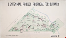
Centennial Project Proposal for Burnaby
https://search.heritageburnaby.ca/link/museumdescription11751
- Repository
- Burnaby Village Museum
- Date
- 1970
- Collection/Fonds
- Burnaby Centennial '71 Committee collection
- Description Level
- Item
- Physical Description
- 1 architectural drawing : black marker and pencil hand col. (pencil crayons) ; 58 x 1012 cm
- Scope and Content
- Item consists of a presentation drawing titled "Centennial Project Proposal for Burnaby" "Drawing 1". Site plan drawing of the future site of Heritage Village.
- Repository
- Burnaby Village Museum
- Collection/Fonds
- Burnaby Centennial '71 Committee collection
- Description Level
- Item
- Physical Description
- 1 architectural drawing : black marker and pencil hand col. (pencil crayons) ; 58 x 1012 cm
- Material Details
- Scale 3 inches = 100 Feet (approx)
- Scope and Content
- Item consists of a presentation drawing titled "Centennial Project Proposal for Burnaby" "Drawing 1". Site plan drawing of the future site of Heritage Village.
- Names
- Burnaby Village Museum
- Accession Code
- BV019.52.87
- Access Restriction
- No restrictions
- Reproduction Restriction
- May be restricted by third party rights
- Date
- 1970
- Media Type
- Architectural Drawing
- Notes
- Transcribed title from drawing
- Drawing is signed "Visti - 70"
Images

![Centennial Project Proposal for Burnaby, [1971] thumbnail](/media/hpo/_Data/_BVM_Architectural_Drawings/2019_0052_0175_001.jpg?width=280)
Centennial Project Proposal for Burnaby
https://search.heritageburnaby.ca/link/museumdescription17542
- Repository
- Burnaby Village Museum
- Date
- [1971]
- Collection/Fonds
- Burnaby Centennial '71 Committee collection
- Description Level
- Item
- Physical Description
- 1 architectural drawing : black ink with col. on board ; 57.5 x 101.5 cm
- Scope and Content
- Item consists of a presentation drawing titled "Centennial Project Proposal for Burnaby - Drawing 2". Drawing includes concept illustrations identified as "Museum Bldg" and "Entrance and Maintenance Bldg". This proposal was part of the Burnaby Centennial '71 Committee's commemorative project for "H…
- Repository
- Burnaby Village Museum
- Collection/Fonds
- Burnaby Centennial '71 Committee collection
- Description Level
- Item
- Physical Description
- 1 architectural drawing : black ink with col. on board ; 57.5 x 101.5 cm
- Scope and Content
- Item consists of a presentation drawing titled "Centennial Project Proposal for Burnaby - Drawing 2". Drawing includes concept illustrations identified as "Museum Bldg" and "Entrance and Maintenance Bldg". This proposal was part of the Burnaby Centennial '71 Committee's commemorative project for "Heritage Village". Elworth house is identified as the "Museum Bldg". The illustration was created by Rudy Kovach of "Hopping/Kovach/Grinnell" Design consultants.
- Accession Code
- BV019.52.175
- Access Restriction
- No restrictions
- Reproduction Restriction
- May be restricted by third party rights
- Date
- [1971]
- Media Type
- Architectural Drawing
- Scan Resolution
- 72
- Scan Date
- 2021-11-10
- Notes
- Title based on contents of drawing
- See also photograph BV005.54.789
Images
![Centennial Project Proposal for Burnaby, [1971] thumbnail](/media/hpo/_Data/_BVM_Architectural_Drawings/2019_0052_0175_001.jpg)
Century Park - Admission Building
https://search.heritageburnaby.ca/link/museumdescription11668
- Repository
- Burnaby Village Museum
- Date
- July 1971
- Collection/Fonds
- Burnaby Centennial '71 Committee collection
- Description Level
- Item
- Physical Description
- 1 architectural drawing : blueline print ; 61 x 91 cm
- Scope and Content
- Item consists of an architectural drawing of "Century Park / Burnaby B.C. / Admission Building / Job No. 7100 1"
- Repository
- Burnaby Village Museum
- Collection/Fonds
- Burnaby Centennial '71 Committee collection
- Description Level
- Item
- Physical Description
- 1 architectural drawing : blueline print ; 61 x 91 cm
- Material Details
- Scale 1/2" = 1'-0"
- Scope and Content
- Item consists of an architectural drawing of "Century Park / Burnaby B.C. / Admission Building / Job No. 7100 1"
- Names
- Burnaby Village Museum
- Accession Code
- BV019.52.4
- Access Restriction
- Subject to FIPPA
- Reproduction Restriction
- Reproductions subject to FIPPA
- Date
- July 1971
- Media Type
- Architectural Drawing
- Notes
- Title based on contents of item
- Stamp on page reads: "Received / Jul 19 1971 / Building Inspector's / Office"
Century Park - Admission Building
https://search.heritageburnaby.ca/link/museumdescription11669
- Repository
- Burnaby Village Museum
- Date
- July 1971
- Collection/Fonds
- Burnaby Centennial '71 Committee collection
- Description Level
- Item
- Physical Description
- 1 architectural drawing : blueline print ; 61 x 91 cm + 2 p. of textual records
- Scope and Content
- Item consists of an architectural drawing of "Century Park / Burnaby B.C. / Admission Building / Job No. 7100 1" with attached typewritten pages "Materials List" from Hopping-Kovach-Grinnell
- Repository
- Burnaby Village Museum
- Collection/Fonds
- Burnaby Centennial '71 Committee collection
- Description Level
- Item
- Physical Description
- 1 architectural drawing : blueline print ; 61 x 91 cm + 2 p. of textual records
- Material Details
- Scale 1/2" = 1'-0"
- Scope and Content
- Item consists of an architectural drawing of "Century Park / Burnaby B.C. / Admission Building / Job No. 7100 1" with attached typewritten pages "Materials List" from Hopping-Kovach-Grinnell
- Names
- Burnaby Village Museum
- Accession Code
- BV019.52.5
- Access Restriction
- Subject to FIPPA
- Reproduction Restriction
- Reproductions subject to FIPPA
- Date
- July 1971
- Media Type
- Architectural Drawing
- Notes
- Title based on contents of item
Century Park - Contract 3 - Bandstand
https://search.heritageburnaby.ca/link/museumdescription11675
- Repository
- Burnaby Village Museum
- Date
- July 9, 1971
- Collection/Fonds
- Burnaby Centennial '71 Committee collection
- Description Level
- File
- Physical Description
- 2 architectural drawings: blueline prints ; 61 x 91 cm
- Scope and Content
- File consists of two copies of architectural drawings of the "Century Park / Bandstand" (Contract 3- Job no. 71001). (one appears to be a Contractor's copy).
- Repository
- Burnaby Village Museum
- Collection/Fonds
- Burnaby Centennial '71 Committee collection
- Description Level
- File
- Physical Description
- 2 architectural drawings: blueline prints ; 61 x 91 cm
- Material Details
- Scales differ
- Scope and Content
- File consists of two copies of architectural drawings of the "Century Park / Bandstand" (Contract 3- Job no. 71001). (one appears to be a Contractor's copy).
- Names
- Burnaby Village Museum
- Accession Code
- BV019.52.11
- Access Restriction
- No restrictions
- Reproduction Restriction
- May be restricted by third party rights
- Date
- July 9, 1971
- Media Type
- Architectural Drawing
- Notes
- Transcribed Title; One plan is stamped: "Received July 19, 1971" and the other includes annotations in pen and red pencil crayon
Century Park Museum Association architectural records and reports series
https://search.heritageburnaby.ca/link/museumdescription13985
- Repository
- Burnaby Village Museum
- Date
- 1972-1989
- Collection/Fonds
- Century Park Museum Association fonds
- Description Level
- Series
- Physical Description
- 219 architectural drawings + 17 technical drawings + .5 m of textual records
- Scope and Content
- Series consists of architectural records, reports and documentation related to the construction, renovation, alteration and expansion of the Heritage Village Museum (Burnaby Village Museum) site and buildings between 1972 and 1989.
- Repository
- Burnaby Village Museum
- Collection/Fonds
- Century Park Museum Association fonds
- Description Level
- Series
- Physical Description
- 219 architectural drawings + 17 technical drawings + .5 m of textual records
- Scope and Content
- Series consists of architectural records, reports and documentation related to the construction, renovation, alteration and expansion of the Heritage Village Museum (Burnaby Village Museum) site and buildings between 1972 and 1989.
- Accession Code
- BV019.52
- BV020.5
- Date
- 1972-1989
- Media Type
- Architectural Drawing
- Textual Record
- Technical Drawing
- Related Material
- See also: Burnaby Centennial '71 Committee collection; Burnaby Village Museum fonds
- Notes
- Title based on contents of series
- Further accruals aare expected
- Contact Burnaby Village Museum for access
Century Park Museum Association fonds
https://search.heritageburnaby.ca/link/museumdescription3781
- Repository
- Burnaby Village Museum
- Date
- 1971-1989
- Collection/Fonds
- Century Park Museum Association fonds
- Description Level
- Fonds
- Physical Description
- 1814 photographs + 219 architectural drawings + 17 technical drawings + 4 videocassettes + 3 audio reels + 17 audio cassettes + 1.6 m of textual records + 2 maps
- Scope and Content
- Fonds consists of records created and collected by the Century Park Museum Association (renamed Burnaby Village Museum Association after 1984), which managed Heritage Village (later named Burnaby Village Museum) from its opening in 1971 until it's dissolution in December 1989. Records include archi…
- Repository
- Burnaby Village Museum
- Collection/Fonds
- Century Park Museum Association fonds
- Description Level
- Fonds
- Physical Description
- 1814 photographs + 219 architectural drawings + 17 technical drawings + 4 videocassettes + 3 audio reels + 17 audio cassettes + 1.6 m of textual records + 2 maps
- Scope and Content
- Fonds consists of records created and collected by the Century Park Museum Association (renamed Burnaby Village Museum Association after 1984), which managed Heritage Village (later named Burnaby Village Museum) from its opening in 1971 until it's dissolution in December 1989. Records include architectural drawings and proposals; photographs and films of the site; documentation of exhibits and artifacts, special events and programs; oral history interviews and other sound recordings; association meeting minutes; constitutions and bylaws; financial records; reports; correspondence; publications and research materials. Fonds has been arranged into the following series: 1) Century Park Museum Association photograph collection series 2) Century Park Museum Association film collection series 3) Century Park Museum Association architectural records and reports series 4) Heritage Village Museum oral history Interviews series 5) Heritage Village Museum presentations and Programming series 6) Century Park Museum Association reports series 7) Century Park Museum Association constitution, bylaws and agreements series 8) Century Park Museum Association minutes of meetings series 9) Century Park Museum association Board of Directors' administrative files series 10) Century Park Museum membership series 11) Heritage Village Museum exhibits and artifacts series 12) Century Park Museum Association committees' minutes and reports series 13) Museum staff adminstrative files series 14) Century Park Museum Association financial records series
- History
- The Heritage Village Museum was originally created as a British Columbia Centennial Project in 1971 through funding from the Federal, Provincial and Municipal governments. A sub-committee of the Burnaby Centennial '71 Committee was responsible for the creation of a permanent commemorative project. The concept for an open-air museum was developed with the location to be in Burnaby on lots 8,9, 10 and 11 of District Lot 79 and Lots 2 and 5, Block "R" of Districts Lots 79 and 85. The official sod turning for Heritage Village took place on April 11, 1971. In the spring of 1971, a museum director and curator were hired to oversee the development of the project and the acquisition of artifacts with funding from the Parks and Recreation Commission. The Century Park Museum Association (CPMA) was founded under the auspices of the Burnaby Centennial '71 Committee to govern Burnaby's Centennial '71 Commemorative Project, Heritage Village. The CPMA Board of directors were elected on October 26, 1971 with Donald (Don) Copan as the founding president (Don continued to serve on the Board until 1989). The Board of Directors reported directly to the Municipal Council. The association had an overall objective of providing a museum that was a historical resource for Burnaby and the region. The museum mandate was to collect, preserve, research, document and interpret artifacts and historical buildings that illustrated the history and lifestyle of the Lower Mainland in B.C. and Burnaby. The Museum focused on the period between 1890 and 1925 depicting a village lifestyle of a small community. This was achieved through the use of exhibits and displays within historic buildings and built reconstructions along with costumed museum interpreters. Many people contributed to the construction and design of the village. Architect, Rudy Kovach created the initial concept drawings and architecture designs were created by architectural design consultants Hopping, Kovach and Grinnell. Many carpenters and tradespeople worked on the construction of the buildings including Mr. Angelo Giacometti who was respsonible for much of the final decorative elements. The official opening of Heritage Village took place on November 19, 1971 with Burnaby Mayor Bob Prittie and Canada’s Governor General Roland Michener. Heritage Village was opened up to the public for a few days between November 19 and 21 with approximately 15,000 visitors. On July 1st, 1972 Heritage Village re-opened for the summer season with CPMA president, Don Copan and Mayor Bob Prittie officiating. This opening showcased further development of the site with more buildings and exhibits added. In 1984, Heritage Village Museum changed its name to “Burnaby Village Museum” and in turn, the Century Park Museum Association changed its name to the “Burnaby Village Museum Association”. Burnaby Village Museum continued to be governed by the Burnaby Village Museum Association until the end of 1989. In 1990, the Corporation of the District of Burnaby assumed the operation and management of Burnaby Village Museum under the Parks, Recreation and Cultural Services Department and the Burnaby Village Museum Association was dissolved.
- Responsibility
- Century Park Museum Association
- Accession Code
- BV985.6028
- BV005.14
- BV000.18
- BV011.44
- BV011.50
- BV014.30
- BV016.56
- BV017.46
- BV018.21
- BV019.52
- BV020.4
- BV020.5
- BV021.5
- BV022.9
- Date
- 1971-1989
- Media Type
- Photograph
- Sound Recording
- Textual Record
- Architectural Drawing
- Moving Images
- Cartographic Material
- Technical Drawing
- Related Material
- Donald Copan fonds
- Burnaby Centennial '71 Committee collection
- Royal Bank exhibit collection
- Bell's Dry Goods exhibit collection
- Jesse Love farmhouse fonds
- Burnaby Village Museum fonds
- Arrangement
- Records are arranged by types and functions of the Century Park Museum Association. The series reflects how they were maintained by the associaton, it's members and staff of Heritage Village (Burnaby Village Museum) while under the governance of the association.
- Notes
- Title based on contents of fonds
- Further accruals are expected
- Some records within this fonds are Closed - contact Burnaby Village Museum for access

Commercial Map of Greater Vancouver and District
https://search.heritageburnaby.ca/link/museumdescription9552
- Repository
- Burnaby Village Museum
- Date
- July 1921
- Collection/Fonds
- Burnaby Village Museum Map collection
- Description Level
- Item
- Physical Description
- 1 map : col. lithograph mounted on linen ; 107 x 138 cm
- Scope and Content
- Commercial map of Greater Vancouver and District. Map depicts district lots, railroads, electric railways, streets, street car stops, schools, buildings, postal block numbers, parks and First Nations reserves. Map covers the geographcial areas of Vancouver, Burnaby, New Westminster, portions of Ric…
- Repository
- Burnaby Village Museum
- Collection/Fonds
- Burnaby Village Museum Map collection
- Description Level
- Item
- Physical Description
- 1 map : col. lithograph mounted on linen ; 107 x 138 cm
- Material Details
- Includes Legend and Index
- Scope and Content
- Commercial map of Greater Vancouver and District. Map depicts district lots, railroads, electric railways, streets, street car stops, schools, buildings, postal block numbers, parks and First Nations reserves. Map covers the geographcial areas of Vancouver, Burnaby, New Westminster, portions of Richmond, West Vancouver, North Vancouver, and Surrey with half mile circles that radiate from Vancouver City Hall on the corner of Main and Hastings. Bottom of map includes an index of street names, along with their corresponding map grid locations. The map is bordered by Marine Drive to the west, North Road to the east, Dempsey Street to the north and 20th Road to the south.
- History
- Bought by donor at thrift store years ago. No known provenance.
- Publisher
- Produced by Photo - Lithography, Colonist , Victoria, B.C.
- Geographic Access
- Vancouver
- Accession Code
- BV018.24.1
- Access Restriction
- No restrictions
- Reproduction Restriction
- No known restrictions
- Date
- July 1921
- Media Type
- Cartographic Material
- Scan Resolution
- 300
- Scan Date
- 16-Jun-20
- Scale
- 100
- Notes
- Transcribed title
- Title on map reads: "COMMERCIAL MAP / OF / GREATER VANCOUVER / AND / DISTRICT / Compiled and Published by / The Vancouver Map & Blueprint Co. Ltd. / 441 Seymour St. Vancouver B.C. / July, 1921".
Images

![Copy of Official British Columbia Road Maps, [193-] thumbnail](/media/hpo/_Data/_BVM_Cartographic_Material/1972/1972_0179_0001_001.jpg?width=280)
Copy of Official British Columbia Road Maps
https://search.heritageburnaby.ca/link/museumdescription18945
- Repository
- Burnaby Village Museum
- Date
- [193-]
- Collection/Fonds
- Burnaby Village Museum Map collection
- Physical Description
- 1 map : lithographic print on sheet ; 43 x 56 cm folded to 22 x 11 cm
- Scope and Content
- Item consists of Road maps of British Columbia presented by Union Oil Company of Canada Limited. Includes seventeen maps printed on both sides of sheet. One side of sheet includes ten separate road maps titled "Cariboo"; "Chilcotin Plateau"; "150 Mile House to Prince George"; "Prince George - Burns…
- Repository
- Burnaby Village Museum
- Collection/Fonds
- Burnaby Village Museum Map collection
- Physical Description
- 1 map : lithographic print on sheet ; 43 x 56 cm folded to 22 x 11 cm
- Material Details
- Scale not defined
- Scope and Content
- Item consists of Road maps of British Columbia presented by Union Oil Company of Canada Limited. Includes seventeen maps printed on both sides of sheet. One side of sheet includes ten separate road maps titled "Cariboo"; "Chilcotin Plateau"; "150 Mile House to Prince George"; "Prince George - Burns Lake"; "Burns Lake - Hazelton"; "Similkameen - Nicola"; "Salmon Arm to Revelstoke"; "Ashcroft to Salmon Arm / Kamloops to Vernon"; "Okanagan Valley"; "Boundary District". Other side of sheet includes seven road maps titled "Vancouver Island"; "Vancouver to Yale"' "Fraser Canyon Section Cariboo Road"; "Lytton to 150 Mile House"; "Arrow and Kootenay Lakes"; "The Kootenays"; "Columbia Valley". When folded, cover of maps reads "COPY OF / OFFICIAL / BRITISH COLUMBIA / ROAD-MAPS" / Presented by / UNION OIL / COMPANY / of Canada Ltd."; verso of cover includes advertisement for Union Motor oil "MOTORITE"; inside cover includes advertisement for Union Gasoline with title reading "See Canada's Evergreen Playground".
- Responsibility
- Union Oil Company of Canada Limited
- Accession Code
- HV972.179.1
- Access Restriction
- No restrictions
- Reproduction Restriction
- No known restrictions
- Date
- [193-]
- Media Type
- Cartographic Material
- Scan Resolution
- 600
- Scan Date
- 2023-08-17
- Notes
- Title based on contents of map
Images
![Copy of Official British Columbia Road Maps, [193-] thumbnail](/media/hpo/_Data/_BVM_Cartographic_Material/1972/1972_0179_0001_001.jpg)

Daily Telegraph War Map of Germany with bombing sites
https://search.heritageburnaby.ca/link/museumdescription20312
- Repository
- Burnaby Village Museum
- Date
- [before 1938] (date of creation of map), annotations added [between 1943 and 1945]
- Collection/Fonds
- Joseph H.C. Corsbie fonds
- Description Level
- Item
- Physical Description
- 1 map : col. lithographic print ; 51 x 77 cm
- Scope and Content
- Item consists of a map entitled "Daily Telegraph War Map of Germany" with secondary title "Daily Telegraph WAR MAP No. 10 Revised Edition". Map was produced prior to the Second World War [pre-Munich International Boundary lines]. Map depicts approximately 47 N to 55 N and from 3E to 22E. The countr…
- Repository
- Burnaby Village Museum
- Collection/Fonds
- Joseph H.C. Corsbie fonds
- Description Level
- Item
- Physical Description
- 1 map : col. lithographic print ; 51 x 77 cm
- Scope and Content
- Item consists of a map entitled "Daily Telegraph War Map of Germany" with secondary title "Daily Telegraph WAR MAP No. 10 Revised Edition". Map was produced prior to the Second World War [pre-Munich International Boundary lines]. Map depicts approximately 47 N to 55 N and from 3E to 22E. The country of Germany sits at the centre of the map bordered by Holland, Belgium and France to the west; Switzerland, Austria and Hungary to the south; Lithuania, Poland, Czechoslavakia, Hungary and Romania to the east and Denmark and the Baltic Sea to the north. Annotations in green ink on the map mark areas of Germany that were bombed during World War Two and were added by Royal Canadian Air Force First Officer Joseph (Joe) H. Corsbie during his service.
- Creator
- Geographia Limited
- Publisher
- Hutchinsons & Co. (Publishers Ltd.) LONDON & MELBORNE"
- Parallel Title
- WAR MAP No. 10 Revised Edition
- Subjects
- Wars - World War, 1939-1945
- Accession Code
- BV020.31.35
- Access Restriction
- No restrictions
- Reproduction Restriction
- No known restrictions
- Date
- [before 1938] (date of creation of map), annotations added [between 1943 and 1945]
- Media Type
- Cartographic Material
- Notes
- Title based on contents of map
- Label printed on verso of map reads: "Daily Telegraph / War Map No. 10 / GERMANY / (REVISED EDITION) / PRICE 1/-NET"
- Copyright. "GEOGRAPHIA" LTD. 167 FLEET STREET, LONDON, E.C.4
- Specially drawn for the Daily Telegraph by "Geographia" Ltd."
- Scale: "Heights in English Feet / Scale of English Miles / Kilometres"

Detail of brass plates for monuments in connection with school sites in Burnaby
https://search.heritageburnaby.ca/link/museumdescription11919
- Repository
- Burnaby Village Museum
- Date
- March 6, 1915
- Collection/Fonds
- Ronald G. Scobbie collection
- Description Level
- Item
- Physical Description
- 1 architectural drawing : pencil and watercolour on blueprint paper ; 43.5 x 30 cm
- Scope and Content
- Item consists of a detail drawing titled "Detail of Brass Plates / for monuments in connection / with School sites, Burnaby - / Full Size”.
- Repository
- Burnaby Village Museum
- Collection/Fonds
- Ronald G. Scobbie collection
- Description Level
- Item
- Physical Description
- 1 architectural drawing : pencil and watercolour on blueprint paper ; 43.5 x 30 cm
- Scope and Content
- Item consists of a detail drawing titled "Detail of Brass Plates / for monuments in connection / with School sites, Burnaby - / Full Size”.
- Creator
- McGugan, Donald Johnston
- Subjects
- Buildings - Schools
- Responsibility
- Burnett & McGugan, Engineers and Surveyors
- Accession Code
- BV003.83.11
- Access Restriction
- No restrictions
- Reproduction Restriction
- No known restrictions
- Date
- March 6, 1915
- Media Type
- Architectural Drawing
- Scan Resolution
- 600
- Scan Date
- 15-Jan-2021
- Scale
- 100
- Notes
- Title based on contents of drawing
- Text on bottom right corner of drawing reads: "Burnett & McGugan / C.E. & B.C. Land Surveyors / New Westminster, BC / 6th March 1915"
- Red crayon marking on plan reads: "001819"
- verso of page is blue
Images

Dominion Bridge Company Limited - Burnaby Plant
https://search.heritageburnaby.ca/link/museumdescription17538
- Repository
- Burnaby Village Museum
- Date
- 29 Aug. 1957
- Collection/Fonds
- Burnaby Village Museum Map collection
- Description Level
- Item
- Physical Description
- 1 plan : col. lithographic print ; 50.5 x 84 cm
- Scope and Content
- Item consists of a fire insurance plan of the Dominion Bridge Company Burnaby Plant located on the east side of Boundary Road near Lougheed Highway. The plan is in two sheets mounted on a backing board. The buildings are located and colour coded. The plan includes profiles of the buildings. Title o…
- Repository
- Burnaby Village Museum
- Collection/Fonds
- Burnaby Village Museum Map collection
- Description Level
- Item
- Physical Description
- 1 plan : col. lithographic print ; 50.5 x 84 cm
- Material Details
- Scale [1:960]
- Scope and Content
- Item consists of a fire insurance plan of the Dominion Bridge Company Burnaby Plant located on the east side of Boundary Road near Lougheed Highway. The plan is in two sheets mounted on a backing board. The buildings are located and colour coded. The plan includes profiles of the buildings. Title on plan reads "DOMINION BRIDGE COMPANY, LIMITED / "BURNABY PLANT" / Burnaby, B.C.". The site plan was surveyed by C. L. Schwaab Jr.
- History
- Dominion Bridge Company was a major enterprise in Burnaby operating from the 1930 until the mid 1970s. Dominion Bridge constructed steel structures ranging from portions of the Golden Gate and Lions Gate Bridges to holding tanks for pulp mills. Beginning in the mid-1970s, unused areas of the site were used for filming on a temporary basis and in 1987 the site was established as a dedicated studio production facility named Bridge Studios.
- Creator
- Schwabb, C.L. Jr.
- Subjects
- Buildings - Industrial - Factories
- Names
- Dominion Bridge Company
- Responsibility
- Associated Factory Mutual Fire Insurance Cos
- Geographic Access
- Boundary Road
- Street Address
- 2400 Boundary Road
- Accession Code
- BV015.10.1
- Access Restriction
- Restricted access
- Reproduction Restriction
- May be restricted by third party rights
- Date
- 29 Aug. 1957
- Media Type
- Cartographic Material
- Historic Neighbourhood
- Broadview (Historic Neighbourhood)
- Planning Study Area
- West Central Valley Area
- Scan Resolution
- 400
- Scan Date
- 2021-11-28
- Notes
- Title based on contents of plan
- Scale on plan reads "1 inch = 80 ft / By V. Pitkin"
- Identfication information in bottom right corner of plan reads: "FACTORY MUTUAL ENGINEERING DIVISION / Associated Factory Mutual Fire Insurance Cos. / Norwood, Mass. / SERIAl 47330 / Replacing 35238 / INDEX 3994"
Donald Copan collection
https://search.heritageburnaby.ca/link/museumdescription3618
- Repository
- Burnaby Village Museum
- Date
- 1971
- Collection/Fonds
- Donald Copan collection
- Description Level
- Fonds
- Physical Description
- 2 cm of textual records + 3 architectural drawings + 17 photographs + 1 scrapbook album (727 photographs + ephemera)
- Scope and Content
- Collection consists of material collected and created by Donald Copan while he was an active member of the Burnaby Centennial '71 Committee and as founding President of the Century Park Museum Association. The fonds includes a scrabpook album of photographs and ephemera documenting the Burnaby Cent…
- Repository
- Burnaby Village Museum
- Collection/Fonds
- Donald Copan collection
- Description Level
- Fonds
- Physical Description
- 2 cm of textual records + 3 architectural drawings + 17 photographs + 1 scrapbook album (727 photographs + ephemera)
- Scope and Content
- Collection consists of material collected and created by Donald Copan while he was an active member of the Burnaby Centennial '71 Committee and as founding President of the Century Park Museum Association. The fonds includes a scrabpook album of photographs and ephemera documenting the Burnaby Centennial '71 Committee's involvement in celebrating British Columbia's Centenary of Confederation between January and December 1971 including Burnaby's Commemorative Project - Heritage Village (Burnaby Village Museum); plans and reports regarding the creation of Heritage Village and a small collection of records regarding British Columbia Summer Games that Burnaby hosted in 1984 and 1997 as well as a small collection of photographs of a wedding taking place at Willingdon Heights United Church. Fonds is arranged into three series: 1) Copan album series 2) Heritage Village project series 3) Copan family photograph series 4) B.C. Summer Games series
- History
- Donald "Don" A. Copan was born in Victoria B.C. in 1928 and moved with his family to East Vancouver in the mid nineteen thirties. Don graduated from Britannia High School in the nineteen forties and graduated from the BC Provincial Normal School in 1948. In 1952, Don married Barbara Thomson. The couple moved to Highlawn Drive in 1954 where they raised their two sons Angus and Todd. Don and his family were active members of the Willingdon Heights United Church. Don's teaching career began at Westridge Elementary School. He worked in Burnaby as an educator, including serving as the Principal of Twelfth Avenue Elementary School and retired from teaching in 1983. He served on the 1958 and 1971 Burnaby Centennial Committees and was the founding President of the Century Park Museum Association (the non-profit society that operated the Heritage Village Museum from 1971 to 1989, now Burnaby Village Museum). Don served on the Executive of the Century Park Museum Association (CPMA) every year of the organization's existence. Don's wife Barbara Copan was also active in the CPMA, as a volunteer with a focus on the gift shop. In 1982, Don became Burnaby's first "Citizen of the Year" and was awarded the Kushiro cup for his volunteerism. Don was also involved in many other community organizations in the 1970s, including serving as President of the Burnaby Region, Boy Scouts (1975), and as a community resource person of the Board of Burnaby Big Brothers Association. He was Chairman of the Burnaby Family Court for seven years and Chairman of the Lower Mainland Family Court Committee for four years. He was also President of the Burnaby Teachers' Association circa 1974. Barbara Copan died in October 2017 and Don died in June 2020.
- Responsibility
- Copan, Donald Angus "Don"
- Accession Code
- BV005.54
- BV021.4
- Access Restriction
- No restrictions
- Reproduction Restriction
- May be restricted by third party rights
- Date
- 1971
- Media Type
- Photograph
- Textual Record
- Architectural Drawing
- Related Material
- Donald Wrigley fonds; Century Park Museum Association fonds; Burnaby Centennial '71 Committee collection
- Notes
- Title based on contents of fonds
- Ephemera from scrapbook is described separately with the Burnaby Village Museum Artifacts collection
- Some photographs have been "Closed" due to poor quality and duplication in content
- For other records regarding the history of Heritage Village Museum see also: Century Park Museum Association fonds; Burnaby Centennial '71 Committee collection and Burnaby Village Museum fonds
- See also B.C. Summer Games artifacts BV021.4.1 to BV021.4.12 & BV021.4.21; BV021.4.25; BV021.4.26

Douglas Road School site
https://search.heritageburnaby.ca/link/museumdescription11136
- Repository
- Burnaby Village Museum
- Date
- April 19, 1915
- Collection/Fonds
- Ronald G. Scobbie collection
- Description Level
- Item
- Physical Description
- 1 survey plan : blueprint on paper ; 56 x 54 cm
- Scope and Content
- Survey plan of "Douglas Road School Site / Burnaby Municipality" "Being Lot 21, of Blocks 1-5 inc. 11 & 12 of the subd. of north half of Lot 80, Group 1, New Westminster District".
- Repository
- Burnaby Village Museum
- Collection/Fonds
- Ronald G. Scobbie collection
- Description Level
- Item
- Physical Description
- 1 survey plan : blueprint on paper ; 56 x 54 cm
- Material Details
- Scale 40 feet = 1 inch
- Scope and Content
- Survey plan of "Douglas Road School Site / Burnaby Municipality" "Being Lot 21, of Blocks 1-5 inc. 11 & 12 of the subd. of north half of Lot 80, Group 1, New Westminster District".
- Creator
- McGugan, Donald Johnston
- Subjects
- Buildings - Schools
- Names
- Douglas Road School
- Responsibility
- Burnett & McGugan, Engineers and Surveyors
- Geographic Access
- Canada Way
- Street Address
- 4861 Canada Way
- Accession Code
- BV003.83.15
- Access Restriction
- No restrictions
- Reproduction Restriction
- No known restrictions
- Date
- April 19, 1915
- Media Type
- Cartographic Material
- Historic Neighbourhood
- Burnaby Lake (Historic Neighbourhood)
- Planning Study Area
- Douglas-Gilpin Area
- Scan Resolution
- 440
- Scan Date
- 22-Dec-2020
- Scale
- 100
- Notes
- Title based on contents of plan
- Note in black ink on verso of plan reads: "1747"
- Oath on plan reads: "I, D.G. McGugan..." "...and did person- ally superintend the survey..." "...completed on the 3rd day of April 1915"; signed by D.J. McGugan, notarized by "H.A. Eastman", sworn "...19th day of April 1915" "Burnett and McGugan" "B.C. Land Surveyors Etc. New Westminster, B.C.."
Images

![Dundonald United Church, [ca.1910] thumbnail](/media/hpo/_Data/_BVM_Cartographic_Material/2003/2003_0083_0052_001.jpg?width=280)
Dundonald United Church
https://search.heritageburnaby.ca/link/museumdescription11930
- Repository
- Burnaby Village Museum
- Date
- [ca.1910]
- Collection/Fonds
- Ronald G. Scobbie collection
- Description Level
- Item
- Physical Description
- 1 plan : black ink and watercol. on paper ; 30.45 x 30.5 cm
- Scope and Content
- Item consists of a building insurance plan of "Dundonald United Church / Lots 9, 10 BK 28 DL 159 GP 1 / N.W.D.". Clinton Street is identified to the north of Lots nine and ten.
- Repository
- Burnaby Village Museum
- Collection/Fonds
- Ronald G. Scobbie collection
- Description Level
- Item
- Physical Description
- 1 plan : black ink and watercol. on paper ; 30.45 x 30.5 cm
- Material Details
- Scale 1 inch = 20 feet
- Scope and Content
- Item consists of a building insurance plan of "Dundonald United Church / Lots 9, 10 BK 28 DL 159 GP 1 / N.W.D.". Clinton Street is identified to the north of Lots nine and ten.
- Subjects
- Buildings - Religious - Churches
- Names
- Dundonald United Church
- Accession Code
- BV003.83.52
- Access Restriction
- No restrictions
- Reproduction Restriction
- No known restrictions
- Date
- [ca.1910]
- Media Type
- Cartographic Material
- Scan Resolution
- 600
- Scan Date
- 15-Jan-2021
- Scale
- 100
- Notes
- Transcribed title
- Note in pencil on verso reads: "_ _Church / Lots 9 & 10 BK 28 DL 159 / 1" = 20' "
- Note in black ink on verso reads: "3704"
Images
![Dundonald United Church, [ca.1910] thumbnail](/media/hpo/_Data/_BVM_Cartographic_Material/2003/2003_0083_0052_001.jpg)
![East Burnaby United Church, [ca.1925] thumbnail](/media/hpo/_Data/_BVM_Cartographic_Material/2003/2003_0083_0054_001.jpg?width=280)
East Burnaby United Church
https://search.heritageburnaby.ca/link/museumdescription11932
- Repository
- Burnaby Village Museum
- Date
- [ca.1925]
- Collection/Fonds
- Ronald G. Scobbie collection
- Description Level
- Item
- Physical Description
- 1 plan : black ink and watercol. on paper ; 30.45 x 30.5 cm
- Scope and Content
- Item consists of a building insurance plan of "East Burnaby United Church / Lot 1 BK 2 south Part DL 28 GP 1 N.W.D.". Twelfth Avenue is identified to the north and Douglas Road to the west.
- Repository
- Burnaby Village Museum
- Collection/Fonds
- Ronald G. Scobbie collection
- Description Level
- Item
- Physical Description
- 1 plan : black ink and watercol. on paper ; 30.45 x 30.5 cm
- Material Details
- Scale 1 inch = 20 feet
- Scope and Content
- Item consists of a building insurance plan of "East Burnaby United Church / Lot 1 BK 2 south Part DL 28 GP 1 N.W.D.". Twelfth Avenue is identified to the north and Douglas Road to the west.
- Subjects
- Buildings - Religious - Churches
- Accession Code
- BV003.83.54
- Access Restriction
- No restrictions
- Reproduction Restriction
- No known restrictions
- Date
- [ca.1925]
- Media Type
- Cartographic Material
- Scan Resolution
- 600
- Scan Date
- 15-Jan-2021
- Scale
- 100
- Notes
- Transcribed title
- Note in pencil on verso reads: "East Burnaby United Church / Lot 1 BK 2 south Part DL 28 / 1" = 20' "
- Note in black ink on verso reads: "3704"
Images
![East Burnaby United Church, [ca.1925] thumbnail](/media/hpo/_Data/_BVM_Cartographic_Material/2003/2003_0083_0054_001.jpg)

Edmonds Street School site
https://search.heritageburnaby.ca/link/museumdescription11125
- Repository
- Burnaby Village Museum
- Date
- March 8, 1915
- Collection/Fonds
- Ronald G. Scobbie collection
- Description Level
- Item
- Physical Description
- 1 survey plan : blueprint on paper ; 56 x 54 cm
- Scope and Content
- Survey plan of "Edmonds Street School Site" "Burnaby Municipality" "Being Lots 28 and 29 of the Subdivision of Lot 30, Group 1, New Westminster District";
- Repository
- Burnaby Village Museum
- Collection/Fonds
- Ronald G. Scobbie collection
- Description Level
- Item
- Physical Description
- 1 survey plan : blueprint on paper ; 56 x 54 cm
- Material Details
- Scale: 4 feet = 1 inch
- Scope and Content
- Survey plan of "Edmonds Street School Site" "Burnaby Municipality" "Being Lots 28 and 29 of the Subdivision of Lot 30, Group 1, New Westminster District";
- Subjects
- Buildings - Schools
- Names
- Edmonds Community School
- Responsibility
- Burnett and McGugan B.C. Land Surveyors, New Westminster
- Geographic Access
- Edmonds Street
- Street Address
- 7641 Edmonds Street
- Accession Code
- BV003.83.5
- Access Restriction
- No restrictions
- Reproduction Restriction
- No known restrictions
- Date
- March 8, 1915
- Media Type
- Cartographic Material
- Historic Neighbourhood
- Edmonds (Historic Neighbourhood)
- Planning Study Area
- Edmonds Area
- Scan Resolution
- 440
- Scan Date
- 22-Dec-2020
- Scale
- 100
- Notes
- Title based on contents of plan
- Oath in bottom left corner reads: "I, D.J. McGugan...and did personally superintend the survey..." "...completed on the 8th day of March 1915"; signed "D.J. McGugan", notarized by "S.F. Mark" "sworn...12th Day of April 1915"
- handwritten on back, "1756"
Zoomable Images

Elmer Wilson Martin fonds
https://search.heritageburnaby.ca/link/museumdescription10611
- Repository
- Burnaby Village Museum
- Date
- 1934-1973
- Collection/Fonds
- Elmer Wilson Martin fonds
- Description Level
- Fonds
- Physical Description
- 42 photographs + 9 architectural drawings + approx. 4 cm of textual records
- Scope and Content
- Fonds consists of photographs of E.W. Martin during his military service with the RCAF; development in Burnaby along Winch Street; Martin's Auto Villa on Hastings and Paneloc buildings together with E.W. Martin's military service records and other records relating to E.W. Martin's involvement with …
- Repository
- Burnaby Village Museum
- Collection/Fonds
- Elmer Wilson Martin fonds
- Description Level
- Fonds
- Physical Description
- 42 photographs + 9 architectural drawings + approx. 4 cm of textual records
- Scope and Content
- Fonds consists of photographs of E.W. Martin during his military service with the RCAF; development in Burnaby along Winch Street; Martin's Auto Villa on Hastings and Paneloc buildings together with E.W. Martin's military service records and other records relating to E.W. Martin's involvement with Paneloc Marketing Ltd. and other businesses. Fonds is arranged in the following series 1) E.W. Martin photographs series 2) E.W. Martin military records and photographs series 3) E.W. Martin business records series
- History
- Elmer Wilson Martin (1909-1973) was a professional engineer who lived most of his life in Burnaby. He was born in Treesbank Manitoba to William Henry Martin and Bethia “Bertie” Snell. Elmer married Ellen "Reta" Renetta Boyd (1908-1984) in approx. 1930. The couple moved to Burnaby in 1931 and Elmer graduated from UBC. Following his graduation from UBC, he spent two years at the University of Saskatchewan doing research. From 1936-1937 he worked at the Port Alice mill of the B.C. Pulp and paper Co and later worked for the Boeing aircraft plant at Vancouver. He joined the RCAF in September 1939, serving as chief engineering officer at various Canadian and overseas stations during WWII, until being discharged as a pilot and wing commander in November 1945. He served as NHA assistant regional engineer for a year after his discharge before becoming the owner and operator of Martin Auto Villa at 6574 East Hastings Street in North Burnaby. He was a director of the Burnaby Board of Trade from 1951 and chairman of the Burnaby Industrial Development Board and a member of the Professional Engineers' Association. He ran for Reeve under the Non-Partisan Association in Burnaby's municipal election in 1959 and donated land on Burnaby Mountain for Simon Fraser University. He had many businesses throughout his life including Paneloc Marketing Ltd. and his last one was as Director with the construction company Webb & Knapp Canada Ltd. The couple lived at various locations in Burnaby including, 6574 East Hastings Street eventually settling at 7231 Sutliff Street in North Burnaby in 1957. Elmer's brother, Wilbert Maurice Martin (1907-1980) was also born in Treesbank, Manitoba. Wilbert "Bert" was married to Eva (nee Erhart) Martin (1911-1993). Wilbert and Eva Martin lived on Winch Street in Burnaby. They first lived at 6776 Winch Street before relocating their house to 6656 Winch Street, Burnaby. Wilbert worked in construction as a building contractor and Eva worked as a hostess in the hotel industry. Paneloc buildings were developed by Elmer W. Martin, president of Paneloc Manufacturing Ltd. beginning in 1957 and were based on a design by A.B. Wenaus and Sons Ltd. In 1964, Martin held patents for his design of paneloc buildings in thirty six countries. Since Martin trained as a mechanical engineer, he developed a plan for his home model over a six year period in series of experiments with materials, styles, methods and sizes. Paneloc homes were prefabricated, using specially built bevelled wall panels cut-pie segments to form both the roof and the floor. The wall panels were designed to squeeze together by two metal straps on a turn-buckle basis. The roof and floor were held in place with factory-installed tap block bolts and a long wooden spine which fit in a keyway between the sections. The prefabricated parts were insulated and built with door and window allowances at Harrigan Industries Ltd. in Vancouver where Martin was part owner. Epoxy resin allowed the panels to be assembled without nails using weather-proofed five ply plywood. Sizes of homes varied using four by eight foot wall panels and increasing the span of the floor and roof sections. Harrigan Industries Ltd. continued to sell the prefabricated paneloc buildings until it went into receivership in late 1974.
- Creator
- Martin, Elmer Wilson
- Accession Code
- BV015.39
- BV019.37
- BV019.40
- Date
- 1934-1973
- Media Type
- Textual Record
- Photograph
- Architectural Drawing
- Arrangement
- The records are organized into three series based on the individual's business work as well as military and personal life. The photograhs series includes both professional and personal content.
- Notes
- Title based on contents of fonds

Fire insurance key plan - Greater Vancouver - Volume XIX - Municipality of Burnaby
https://search.heritageburnaby.ca/link/museumdescription17799
- Repository
- Burnaby Village Museum
- Date
- 1927
- Collection/Fonds
- Burnaby Village Museum Map collection
- Description Level
- Item
- Physical Description
- 1 plan on 1 sheet : col. lithographic print ; 64 x 54 cm
- Scope and Content
- Item consists of a one page fire insurance key plan titled "Greater Vancouver / Volume XIX / Municipality / of Burnaby / Key Plan" surveyed May 1927. Key plan from compilation, "Insurance Plans of Greater Vancouver Plan No. 11, Volumes 15 to 19 Burnaby".
- Repository
- Burnaby Village Museum
- Collection/Fonds
- Burnaby Village Museum Map collection
- Description Level
- Item
- Physical Description
- 1 plan on 1 sheet : col. lithographic print ; 64 x 54 cm
- Material Details
- Scale [1:6000]
- Scope and Content
- Item consists of a one page fire insurance key plan titled "Greater Vancouver / Volume XIX / Municipality / of Burnaby / Key Plan" surveyed May 1927. Key plan from compilation, "Insurance Plans of Greater Vancouver Plan No. 11, Volumes 15 to 19 Burnaby".
- Publisher
- Plan Department of Fire Branch of British Columbia Underwriters' Association
- Accession Code
- BV987.1.70
- Access Restriction
- No restrictions
- Reproduction Restriction
- May be restricted by third party rights
- Date
- 1927
- Media Type
- Cartographic Material
- Historic Neighbourhood
- Fraser Arm (Historic Neighbourhood)
- Planning Study Area
- Big Bend Area
- Scan Resolution
- 400
- Scan Date
- 2021-11-17
- Notes
- Title based on contents of item
- Scale 500 feet = 1 inch
- These plans were removed from a bound book with labels on cover page reading: "Plan No. 90 / THIS INSURANCE PLAN / of / Vancouver VOLUME "8" / IN THE PROPERTY OF THE / British Columbia Insurance Underwriter's Association / Vancouver B.C. / AND IS LOANED / MELVILLE F. THOMSON CO. .../ Date May 26th, 1934"; / "Plan No. 74 / THIS INSURANCE PLAN / OF / VANCOUVER VOLUME "9"" / Plan No. 11 / THIS INSURANCE PLAN / OF / BURNABY VOLUMES 15-19" / "THIS PLAN IS THE PROPERTY OF / THE / BRITISH LAW INSURANCE COMPANY / LIMITED"
- Does not include the corresponding key plan page or associated plans numbered 1901 to 1914
- Contact Burnaby Village Museum to view associated fire insurance plans
Zoomable Images

Fire insurance key plan - Greater Vancouver - Volume XIX - Municipality of Burnaby, 1927
Zoom into Image
Fire insurance key plan - Greater Vancouver - Volume XVI - Municipality of Burnaby
https://search.heritageburnaby.ca/link/museumdescription17796
- Repository
- Burnaby Village Museum
- Date
- 1927
- Collection/Fonds
- Burnaby Village Museum Map collection
- Description Level
- Item
- Physical Description
- 2 plans on 2 sheets: col. lithographic print ; 64 x 54 cm
- Scope and Content
- Item consists of a two page fire insurance key plan titled "Greater Vancouver / Volume XVI / Municipality / of Burnaby / Key Plan" surveyed May 1927. Volume XVI includes a two page Key Plan (C and D). .
- Repository
- Burnaby Village Museum
- Collection/Fonds
- Burnaby Village Museum Map collection
- Description Level
- Item
- Physical Description
- 2 plans on 2 sheets: col. lithographic print ; 64 x 54 cm
- Scope and Content
- Item consists of a two page fire insurance key plan titled "Greater Vancouver / Volume XVI / Municipality / of Burnaby / Key Plan" surveyed May 1927. Volume XVI includes a two page Key Plan (C and D). .
- Publisher
- Plan Department of Fire Branch of British Columbia Underwriters Association
- Accession Code
- BV987.1.70
- Access Restriction
- No restrictions
- Reproduction Restriction
- May be restricted by third party rights
- Date
- 1927
- Media Type
- Cartographic Material
- Scan Resolution
- 400
- Scan Date
- 11/17/2021
- Notes
- Title based on contents of item
- Item "GREATER VANCOUVER / VOLUME XVI / MUNICIPALITY OF / BURNABY / KEY PLAN" does not include associated numbered plans (1601 to 1651)
- These plans were removed from a bound book with labels on cover page reading: "Plan No. 90 / THIS INSURANCE PLAN / of / Vancouver VOLUME "8" / IN THE PROPERTY OF THE / British Columbia Insurance Underwriter's Association / Vancouver B.C. / AND IS LOANED / MELVILLE F. THOMSON CO. .../ Date May 26th, 1934"; / "Plan No. 74 / THIS INSURANCE PLAN / OF / VANCOUVER VOLUME "9"" / Plan No. 11 / THIS INSURANCE PLAN / OF / BURNABY VOLUMES 15-19" / "THIS PLAN IS THE PROPERTY OF / THE / BRITISH LAW INSURANCE COMPANY / LIMITED"
Zoomable Images

Fire insurance key plan - Greater Vancouver - Volume XVI - Municipality of Burnaby, 1927
Zoom into Image
Fire insurance plans - Greater Vancouver - Volume XVIII - Municipality of Burnaby
https://search.heritageburnaby.ca/link/museumdescription17798
- Repository
- Burnaby Village Museum
- Date
- 1927-1950
- Collection/Fonds
- Burnaby Village Museum Map collection
- Description Level
- Item
- Physical Description
- 22 plans on 12 sheets : col. lithographic print ; 64 x 54 cm
- Scope and Content
- Item consists of fire insurance plans titled "Greater Vancouver / Volume XVIII / Municipality / of Burnaby" surveyed May 1927, revised in October 1940 and September 1950. Includes a two page key plan (G and H) and twenty associated plans numbered; 1801; 1802; 1803; 1804; 1805; 1806; 1807; 1808; 18…
- Repository
- Burnaby Village Museum
- Collection/Fonds
- Burnaby Village Museum Map collection
- Description Level
- Item
- Physical Description
- 22 plans on 12 sheets : col. lithographic print ; 64 x 54 cm
- Material Details
- Scales between [1:600] and [1:6000]
- Scope and Content
- Item consists of fire insurance plans titled "Greater Vancouver / Volume XVIII / Municipality / of Burnaby" surveyed May 1927, revised in October 1940 and September 1950. Includes a two page key plan (G and H) and twenty associated plans numbered; 1801; 1802; 1803; 1804; 1805; 1806; 1807; 1808; 1809; 1810; 1811; 1812; 1813; 1814; 1815; 1819; 1820; 1821; 1822 and 1832.
- Publisher
- Plan Department of Fire Branch of British Columbia Underwriters' Association
- Accession Code
- BV987.1.70
- Access Restriction
- No restrictions
- Reproduction Restriction
- May be restricted by third party rights
- Date
- 1927-1950
- Media Type
- Cartographic Material
- Scan Resolution
- 400
- Scan Date
- 11/17/2021
- Notes
- Title based on contents of item
- Scale 1 inch = 50 feet
- These plans were removed from a bound book with labels on cover page reading: "Plan No. 90 / THIS INSURANCE PLAN / of / Vancouver VOLUME "8" / IN THE PROPERTY OF THE / British Columbia Insurance Underwriter's Association / Vancouver B.C. / AND IS LOANED / MELVILLE F. THOMSON CO. .../ Date May 26th, 1934"; / "Plan No. 74 / THIS INSURANCE PLAN / OF / VANCOUVER VOLUME "9"" / Plan No. 11 / THIS INSURANCE PLAN / OF / BURNABY VOLUMES 15-19" / "THIS PLAN IS THE PROPERTY OF / THE / BRITISH LAW INSURANCE COMPANY / LIMITED"
- Contact Burnaby Village Museum to view associated fire insurance plans
Fire insurance plans - Greater Vancouver - Volume XVII - Municipality of Burnaby
https://search.heritageburnaby.ca/link/museumdescription17797
- Repository
- Burnaby Village Museum
- Date
- 1927-1950
- Collection/Fonds
- Burnaby Village Museum Map collection
- Description Level
- Item
- Physical Description
- 4 plans on 4 sheets : col. lithographic prints
- Scope and Content
- Item consists of fire insurance plans titled "Greater Vancouver / Volume XVII / Municipality / of Burnaby" surveyed May 1927, revised in October 1940 and September 1950. Includes a two page key plan (E and F) and two associated plans numbered 1729 and 1738 (located within District Lot 35).
- Repository
- Burnaby Village Museum
- Collection/Fonds
- Burnaby Village Museum Map collection
- Description Level
- Item
- Physical Description
- 4 plans on 4 sheets : col. lithographic prints
- Scope and Content
- Item consists of fire insurance plans titled "Greater Vancouver / Volume XVII / Municipality / of Burnaby" surveyed May 1927, revised in October 1940 and September 1950. Includes a two page key plan (E and F) and two associated plans numbered 1729 and 1738 (located within District Lot 35).
- Publisher
- Plan Department of Fire Branch of British Columbia Underwriters' Association
- Accession Code
- BV987.1.70
- Access Restriction
- No restrictions
- Reproduction Restriction
- May be restricted by third party rights
- Date
- 1927-1950
- Media Type
- Cartographic Material
- Historic Neighbourhood
- Central Park (Historic Neighbourhood)
- Planning Study Area
- Garden Village Area
- Scan Resolution
- 400
- Scan Date
- 2021-11-17
- Notes
- Title based on contents of item
- These plans were removed from a bound book with labels on cover page reading: "Plan No. 90 / THIS INSURANCE PLAN / of / Vancouver VOLUME "8" / IN THE PROPERTY OF THE / British Columbia Insurance Underwriter's Association / Vancouver B.C. / AND IS LOANED / MELVILLE F. THOMSON CO. .../ Date May 26th, 1934"; / "Plan No. 74 / THIS INSURANCE PLAN / OF / VANCOUVER VOLUME "9"" / Plan No. 11 / THIS INSURANCE PLAN / OF / BURNABY VOLUMES 15-19" / "THIS PLAN IS THE PROPERTY OF / THE / BRITISH LAW INSURANCE COMPANY / LIMITED"
- Contact Burnaby Village Museum to view associated fire insurance plans XVIII
Fire insurance plans - Greater Vancouver - Volume XV - Municipality of Burnaby
https://search.heritageburnaby.ca/link/museumdescription17795
- Repository
- Burnaby Village Museum
- Date
- 1927-1940
- Collection/Fonds
- Burnaby Village Museum Map collection
- Description Level
- Item
- Physical Description
- 11 plans on 8 sheets : col. lithographic print ; 64 x 54 cm
- Scope and Content
- Item consists of fire insurance plans titled "Greater Vancouver / Volume XV / Municipality / of Burnaby" surveyed May 1927 and revised October 1940. Volume XV includes a two page Key Plan (A and B) identifying associated plan numbers and district lots and nine numbered fire insurance plans identifi…
- Repository
- Burnaby Village Museum
- Collection/Fonds
- Burnaby Village Museum Map collection
- Description Level
- Item
- Physical Description
- 11 plans on 8 sheets : col. lithographic print ; 64 x 54 cm
- Material Details
- Scales between [1:600] and [1:6000]
- Scope and Content
- Item consists of fire insurance plans titled "Greater Vancouver / Volume XV / Municipality / of Burnaby" surveyed May 1927 and revised October 1940. Volume XV includes a two page Key Plan (A and B) identifying associated plan numbers and district lots and nine numbered fire insurance plans identified as; 1507; 1508 ; 1517; 1518; 1519; 1520;1521; 1531and 1532.
- Publisher
- Plan Department of Fire Branch of British Columbia Underwriters' Association
- Accession Code
- BV987.1.70
- Access Restriction
- No restrictions
- Reproduction Restriction
- May be restricted by third party rights
- Date
- 1927-1940
- Media Type
- Cartographic Material
- Historic Neighbourhood
- Vancouver Heights (Historic Neighbourhood)
- Planning Study Area
- Burnaby Heights Area
- Willingdon Heights Area
- Scan Resolution
- 400
- Notes
- Title based on contents of item
- These plans are contained within a bound book with labels on cover page reading: "Plan No. 90 / THIS INSURANCE PLAN / of / Vancouver VOLUME "8" / IN THE PROPERTY OF THE / British Columbia Insurance Underwriter's Association / Vancouver B.C. / AND IS LOANED / MELVILLE F. THOMSON CO. .../ Date May 26th, 1934"; / "Plan No. 74 / THIS INSURANCE PLAN / OF / VANCOUVER VOLUME "9"" / Plan No. 11 / THIS INSURANCE PLAN / OF / BURNABY VOLUMES 15-19" / "THIS PLAN IS THE PROPERTY OF / THE / BRITISH LAW INSURANCE COMPANY / LIMITED"
- Fire insurance plans cover various district lots in Burnaby including: District Lot 116,121, 186 and 187.
- Sticker adhered to Key Plan B reads: "
- Contact Burnaby Village Museum to view fire insurance plans that are part of Volume XV
Fire insurance Plans of Greater Vancouver and Burnaby series
https://search.heritageburnaby.ca/link/museumdescription17803
- Repository
- Burnaby Village Museum
- Date
- 1925-1957
- Collection/Fonds
- Burnaby Village Museum Map collection
- Description Level
- Series
- Physical Description
- over 100 plans on multiple sheets : col. lithographic prints
- Scope and Content
- Series consists of fire insurance plans of Greater Vancouver and Burnaby created by the British Columbia Insurance Underwriters Association and a fire insurance plan of the Dominion Bridge Company, Burnaby Plant created by Associated Factory Mutual Fire Insurance Co.
- Repository
- Burnaby Village Museum
- Collection/Fonds
- Burnaby Village Museum Map collection
- Description Level
- Series
- Physical Description
- over 100 plans on multiple sheets : col. lithographic prints
- Scope and Content
- Series consists of fire insurance plans of Greater Vancouver and Burnaby created by the British Columbia Insurance Underwriters Association and a fire insurance plan of the Dominion Bridge Company, Burnaby Plant created by Associated Factory Mutual Fire Insurance Co.
- History
- The British Columbia Underwriters' Association was founded in Victoria in 1880, most likely under the name British Columbia Fire Underwriters Association. In 1928 the organisation changed its name to the British Columbia Insurance Underwriters Association, and again in 1940 to the British Columbia Underwriters Association.
- Accession Code
- HV972.111
- BV987.1.70
- BV015.10.1
- Date
- 1925-1957
- Media Type
- Cartographic Material
- Notes
- Title based on contents of series
Gerald F. Sanders and Alice Sparman Sanders fonds
https://search.heritageburnaby.ca/link/museumdescription18831
- Repository
- Burnaby Village Museum
- Date
- 1918-2016
- Collection/Fonds
- Gerald F. Sanders and Alice Sparman Sanders fonds
- Description Level
- Fonds
- Physical Description
- 33 photographs + 7 architectural drawings +1 cm of textual records
- Scope and Content
- Fonds consists of family photographs and personal papers pertaining to Gerald Frank Sanders and Alice Viola Sparman Sanders along with architectural plans pertaining to the family home located on Spruce Street in Burnaby. Fonds has been arranged into the following series: 1) Sanders-Sparman photog…
- Repository
- Burnaby Village Museum
- Collection/Fonds
- Gerald F. Sanders and Alice Sparman Sanders fonds
- Description Level
- Fonds
- Physical Description
- 33 photographs + 7 architectural drawings +1 cm of textual records
- Scope and Content
- Fonds consists of family photographs and personal papers pertaining to Gerald Frank Sanders and Alice Viola Sparman Sanders along with architectural plans pertaining to the family home located on Spruce Street in Burnaby. Fonds has been arranged into the following series: 1) Sanders-Sparman photographs series 2) Sanders family personal papers 3) Sanders family architectural drawings
- History
- Gerald Frank Sanders (1916-2017) was born August 28, 1916 in Hackney, London. In 1918, Gerald immigrated to Canada with his mother Harriett Sanders (nee Chalkley) (1889-1962) while his father, Frank (1887-1967) was convalescing in hospital in England after succumbing to wounds while serving in action during WWI. Gerald's father, Frank soon joined them in British Columbia. In 1926 they settled in a house located at 4312 Spruce Street near the corner of Spruce Street and Carleton Avenue. By 1946 the family grew in size to four children (Gerald, Leslie, Reginald and Eileen) and they built a larger house right on the corner of Spruce and Carleton Avenue. Gerald attended Inman Elementary, then Van Technical School. He eventually joined the RAF during WWII as an airplane mechanic in England. He sent his pay home and his mother purchased two lots on Pine Street with some of the money. On March 8, 1948 Gerald married Alice Viola Sparman (1925-1996) and the couple lived in the Sanders' family home on Spruce Street. Alice grew up near Cranbrook and spent her teenage years in Victoria. She trained to be a nurse at St. Paul’s Hospital in Vancouver before marrying Gerald. Alice worked at the Burnaby General Hospital from 1952. Gerald and Alice had six children: Dennis, Kris, Kerry, David, Ruth and Marie. In 1949 with the help of family and friends Gerald built a new house located at 4325 Pine Street (address after 1959- 4091 Pine Street) and he moved in with his family. Gerald worked as a carpenter on various projects including the dentistry building at University of British Columbia, the Vancouver Court House and Jack Poole's house in the British Properties. Gerald lived in Burnaby until his death in 2017. Frank and Harriett Sanders lived on Spruce Street until Harriett died in 1962. Frank continued to live on Spruce Street until 1964 and then lived with his son Gerald on Pine Street until his death in 1967.
- Accession Code
- BV018.34
- Date
- 1918-2016
- Media Type
- Photograph
- Architectural Drawing
- Textual Record
- Arrangement
- Records and series were arranged by specific record types.
- Notes
- Title based on contents of fonds

Gilmour Avenue School site
https://search.heritageburnaby.ca/link/museumdescription11129
- Repository
- Burnaby Village Museum
- Date
- May 27, 1915
- Collection/Fonds
- Ronald G. Scobbie collection
- Description Level
- Item
- Physical Description
- 1 survey plan : blueprint on paper ; 56 x 54 cm
- Scope and Content
- Survey plan of Gilmore Avenue School site. Title on plan reads: "Gilmour Avenue School Site / Burnaby Municipality / Being Lots 1-10 inc. & Lots 27-36 inc. of Block 9 / of Subdivision of a Portion of Lot 187, GP.1 / New Westminster District". "Note. School site is as shown below, the original...am…
- Repository
- Burnaby Village Museum
- Collection/Fonds
- Ronald G. Scobbie collection
- Description Level
- Item
- Physical Description
- 1 survey plan : blueprint on paper ; 56 x 54 cm
- Material Details
- Scale: 40 feet = 1 inch
- Scope and Content
- Survey plan of Gilmore Avenue School site. Title on plan reads: "Gilmour Avenue School Site / Burnaby Municipality / Being Lots 1-10 inc. & Lots 27-36 inc. of Block 9 / of Subdivision of a Portion of Lot 187, GP.1 / New Westminster District". "Note. School site is as shown below, the original...amended" "by cancelling Lots 1-10 & 27-30 inc....order of court filed No.4938".
- History
- The school was named after Hugh B. Gilmour, but an error by a municipal clerk in the Street Naming Bylaw in 1912 (Bylaw Number 135) changed the spelling to "Gilmore" Avenue and the school name was spelled "Gilmore" Avenue School hereafter.
- Creator
- McGugan, Donald Johnston
- Subjects
- Buildings - Schools
- Names
- Gilmore Avenue School
- Responsibility
- Burnett & McGugan, Engineers and Surveyors
- Geographic Access
- Gilmore Avenue
- Accession Code
- BV003.83.8
- Access Restriction
- No restrictions
- Reproduction Restriction
- No known restrictions
- Date
- May 27, 1915
- Media Type
- Cartographic Material
- Historic Neighbourhood
- Vancouver Heights (Historic Neighbourhood)
- Planning Study Area
- Willingdon Heights Area
- Scan Resolution
- 440
- Scan Date
- 22-Dec-2020
- Scale
- 100
- Notes
- Transcribed title taken from plan
- Oath in bottom left corner reads: "I, D.J. McGugan...did superintend the survey", "...completed on the 27th day of May 1915" and noterized by Walter Edmonds" "sworn...29th Day of May 1915"; "Burnett and McGugan. B.C. Land Surveyors Etc. New Westminster. B.C."
- Note in black ink on verso of plan reads: "1782"
Zoomable Images

![Gordon Presbyterian Church, [ca.1912] thumbnail](/media/hpo/_Data/_BVM_Cartographic_Material/2003/2003_0083_0045_001.jpg?width=280)
Gordon Presbyterian Church
https://search.heritageburnaby.ca/link/museumdescription11923
- Repository
- Burnaby Village Museum
- Date
- [ca.1912]
- Collection/Fonds
- Ronald G. Scobbie collection
- Description Level
- Item
- Physical Description
- 1 plan : black ink and watercol. on paper ; 30.45 x 30.5 cm
- Scope and Content
- Item consists of building insurance plan of "Gordon Presbyterian Church / Blocks 1-2 BK 7 DL 30 GP1 N.W.D.". Arbutus Street is identified to the north of Lots 1, 2, & 3 and Humphries Avenue to the east.
- Repository
- Burnaby Village Museum
- Collection/Fonds
- Ronald G. Scobbie collection
- Description Level
- Item
- Physical Description
- 1 plan : black ink and watercol. on paper ; 30.45 x 30.5 cm
- Material Details
- Scale 1 inch = 20 feet
- Scope and Content
- Item consists of building insurance plan of "Gordon Presbyterian Church / Blocks 1-2 BK 7 DL 30 GP1 N.W.D.". Arbutus Street is identified to the north of Lots 1, 2, & 3 and Humphries Avenue to the east.
- Subjects
- Buildings - Religious - Churches
- Accession Code
- BV003.83.45
- Access Restriction
- No restrictions
- Reproduction Restriction
- No known restrictions
- Date
- [ca.1912]
- Media Type
- Cartographic Material
- Scan Resolution
- 600
- Scan Date
- 15-Jan-2021
- Scale
- 100
- Notes
- Transcribed title
- Note in pencil on verso reads: "Gordon Presbyterian Church / Blocks 1-2 BK 7 DL 30 / Scale 1 inch = 20 feet" "Total area Lot 1 / Portion exempted / Total area Lot 2 / Portion exempted"
- Note in balck in on verso reads: "3704"
Images
![Gordon Presbyterian Church, [ca.1912] thumbnail](/media/hpo/_Data/_BVM_Cartographic_Material/2003/2003_0083_0045_001.jpg)

Hamilton Road School site
https://search.heritageburnaby.ca/link/museumdescription11139
- Repository
- Burnaby Village Museum
- Date
- April 27, 1915
- Collection/Fonds
- Ronald G. Scobbie collection
- Description Level
- Item
- Physical Description
- 1 survey plan : blueprint on paper ; 56 x 54 cm
- Scope and Content
- Survey plan of "Hamilton Road School Site / Burnaby Municipality" "Being the westerly 2 acres of Block 2 of the subd. of a portion of Lot 8, Group 1"; "New Westminster District”.
- Repository
- Burnaby Village Museum
- Collection/Fonds
- Ronald G. Scobbie collection
- Description Level
- Item
- Physical Description
- 1 survey plan : blueprint on paper ; 56 x 54 cm
- Material Details
- Scale 40 feet = 1 inch
- Scope and Content
- Survey plan of "Hamilton Road School Site / Burnaby Municipality" "Being the westerly 2 acres of Block 2 of the subd. of a portion of Lot 8, Group 1"; "New Westminster District”.
- Creator
- Burnett, Geoffrey K.
- Subjects
- Buildings - Schools
- Names
- Hamilton Road School
- Responsibility
- Burnett & McGugan, Engineers and Surveyors
- Geographic Access
- Lyndhurst Street
- Accession Code
- BV003.83.18
- Access Restriction
- No restrictions
- Reproduction Restriction
- No known restrictions
- Date
- April 27, 1915
- Media Type
- Cartographic Material
- Historic Neighbourhood
- Burquitlam (Historic Neighbourhood)
- Planning Study Area
- Sperling-Broadway Area
- Scan Resolution
- 440
- Scan Date
- 22-Dec-2020
- Scale
- 100
- Notes
- Title based on contents of plan
- handwritten on back, "1752" and mathematical calculations
- Oath on plan reads: "I, Geoffrey K. Burnett...and did person- ally superintend the survey..." "...completed on the 27th day of April 1915"; signed by Geoffrey K. Burnett, notary illegible, sworn "...27th day of April 1915" "Burnett and McGugan" "B.C. Land Surveyors Etc. New Westminster, B.C."
Images

Herbert Yee Law family fonds
https://search.heritageburnaby.ca/link/museumdescription18929
- Repository
- Burnaby Village Museum
- Date
- [1938-1959] (date of originals), 2017-2019 (date of duplication)
- Collection/Fonds
- Herbert Yee Law family fonds
- Description Level
- Fonds
- Physical Description
- 4 photographs (tiffs + jpgs)
- Scope and Content
- Fonds consists of a collection of photographs of Herbert Yee Law, United Fruit Growers, his farm on Marine Drive and a scanned copy of a survey plan of District Lots 163, 162, 157, 158 and 165.
- Repository
- Burnaby Village Museum
- Collection/Fonds
- Herbert Yee Law family fonds
- Description Level
- Fonds
- Physical Description
- 4 photographs (tiffs + jpgs)
- Scope and Content
- Fonds consists of a collection of photographs of Herbert Yee Law, United Fruit Growers, his farm on Marine Drive and a scanned copy of a survey plan of District Lots 163, 162, 157, 158 and 165.
- History
- Herbert (Yee) Law was born in New Westminster British Columbia in 1916. Between 1938 and 1945, Yee Law worked for the United Fraser Growers Limited in Vancouver. The company was a wholesaler that purchased produce from Chinese farmers. In 1948 Yee Law purchased land from another Chinese family along Marine Drive in the Big Bend Area of Burnaby. From this location, Yee Law operated a Chinese market garden. Yee Law and his wife Jean had five daughters who attended schools in the area including Riverway West School, McPherson Park School and Burnaby South High School. In 1954, Yee Law continued to live in the area but left his farm to work for a plastic bag company on Annacis Island. Herbert (Yee) Law died in 2003.
- Creator
- Law, Yee "Herbert"
- Accession Code
- BV017.40
- BV019.11
- Date
- [1938-1959] (date of originals), 2017-2019 (date of duplication)
- Media Type
- Photograph
- Cartographic Material
- Notes
- Title based on contents of fonds