Narrow Results By
Person / Organization
- British Columbia Ferry Services Incorporated 1
- British Columbia Provincial Police 1
- Burnaby Monumental Works 1
- Burnaby Village Museum 2
- Canada Summer Games 1
- Century Park Museum Association 2
- City of Burnaby
- C.W. Parker Company 1
- Girl Guides of Canada 2
- Henderson, Vivian 1
- Hill, Annie Sara Kenrick
- Hill, Louis Claude "Claude" 2

Jubilee Grove Arch
https://search.heritageburnaby.ca/link/landmark533
- Repository
- Burnaby Heritage Planning
- Description
- The Jubilee Grove Arch sits at the corner of Kingsway and Patterson Avenue. Located within Central Park, the ceremonial arch and its decorative plantings provide a visual anchor to the northeast corner and entry point to the park.
- Associated Dates
- 1939
- Formal Recognition
- Heritage Designation, Community Heritage Register
- Street View URL
- Google Maps Street View
- Repository
- Burnaby Heritage Planning
- Geographic Access
- Imperial Street
- Associated Dates
- 1939
- Formal Recognition
- Heritage Designation, Community Heritage Register
- Enactment Type
- Bylaw No. 9807
- Enactment Date
- 23/11/1992
- Description
- The Jubilee Grove Arch sits at the corner of Kingsway and Patterson Avenue. Located within Central Park, the ceremonial arch and its decorative plantings provide a visual anchor to the northeast corner and entry point to the park.
- Heritage Value
- Jubilee Grove Arch was dedicated as part of the municipality’s celebration of the Jubilee of the coronation of King George V and was dedicated during Burnaby’s annual May Day celebrations in 1935. Much of the construction work was carried out by local citizens under the direction of the Burnaby Engineering Department through a Depression era work relief program that provided a way for local residents to pay their taxes. The garden was also chosen as the site for the ceremonial planting of an oak tree from the Royal Forest at Windsor, in honor of the Coronation of King George VI and Queen Elizabeth in 1937. The original bronze garden dedication plaque and oak tree remain at the site today. The decorative stone arch was erected in 1939 as a symbol of Burnaby's, and the Lower Mainland of British Columbia’s, strong ties to the English monarchy at the time, and the arch’s unveiling during May Day ceremonies shows the social role that such a commemorative feature played both to the local government and people of Burnaby. It was erected just prior to the Royal Visit of 1939, the first time that reigning British monarchs had travelled to Canada. Built of Haddington Island sandstone, the arch itself was reconstructed from a salvaged architectural element of a historic Vancouver landmark. The arch originally framed the entrance door to the Vancouver Club building in Vancouver, built in 1893-94 on West Hastings Street and designed by architect C.O. Wickenden. The building was demolished in 1930, however the arch was stored and rebuilt as the focal point of the Jubilee Grove after being bought by the Municipality of Burnaby. The work was undertaken by Italian-born stone mason Rizieri Stefanini (1879-1954), the owner of Burnaby Monumental Works. The re-use of the arch symbolizes the close tie between Vancouver and Burnaby and the joint evolution of the neighbouring cities.
- Defining Elements
- The Jubilee Grove Arch has character-defining elements that recognize it both as a remnant of a past building and as a new and individual structure. These include its: - axial diagonal placement and prominent corner location marking one of the entries to Central Park - visibility and accessibility as a public monument - hand carved stone blocks of Haddington Island sandstone - decorative twisted-rope motif carved to outline the arch - supporting rusticated sidewalls with planting urns - original bronze dedication plaque - flanking ornamental gardens - Royal Oak tree and plaque
- Historic Neighbourhood
- Central Park (Historic Neighbourhood)
- Planning Study Area
- Maywood Area
- Organization
- City of Burnaby
- Architect
- C.O. Wickenden
- Function
- Primary Current--Park Fixture
- Primary Historic--Park Fixture
- Community
- Burnaby
- Cadastral Identifier
- P.I.D. No. 017-767-172 Legal Description: Block B of Lot 2 Except Firstly: Part on Plan 8669 and Secondly: Part on Plan LMP4689 District Lot 151, Group 1, New Westminster District, Plan 3443
- Boundaries
- The property (Central Park) is a municipally-owned park that lies at the western edge of Burnaby, between 49th Avenue to the south, Kingsway to the north, Boundary Road to the west and Patterson Avenue to the east.
- Area
- 853,403.82
- Contributing Resource
- Structure
- Landscape Feature
- Ownership
- Public (local)
- Documentation
- Heritage Site Files: PC77000 20. City of Burnaby Planning and Building Department, 4949 Canada Way, Burnaby, B.C., V5G 1M2
- Names
- Burnaby Monumental Works
- Street Address
- 3883 Imperial Street
- Street View URL
- Google Maps Street View
Images


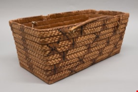
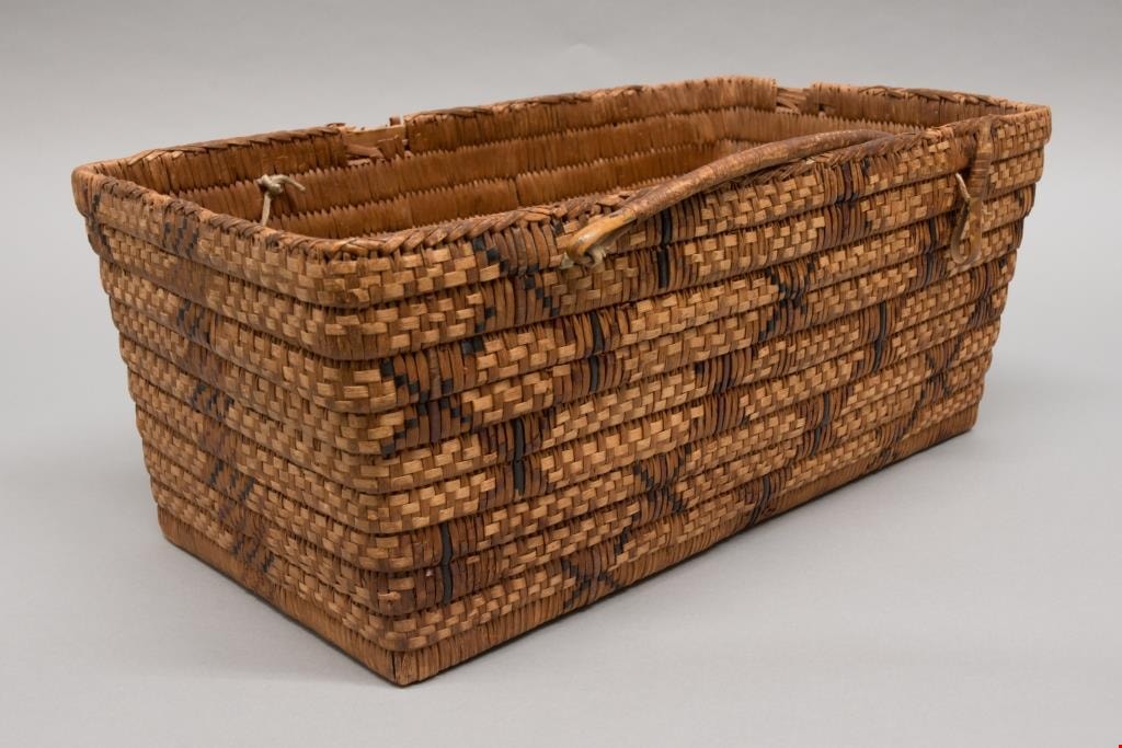
carrying basket
https://search.heritageburnaby.ca/link/museumartifact80210
- Repository
- Burnaby Village Museum
- Accession Code
- BV009.1.1
- Description
- Rectangular coiled cedar root basket with cedar slat foundation and walls that flare slightly towards rim. Decorated in beaded designs of cattail grass and black dyed cherry bark. Darker elements arranged in a butterfly design. Butterflies are said to represent everlasting life by Stó:lō and Nlaka’pamux basket makers. Overcast handles sewn to basket with leather ties. One has been repaired with string. Finished with a braided rim. Triangular shaped stitches attach base to walls of basket. Interior Salish: Stl’atl’imx?
- Object History
- Basket, ca. 1895-1910, from the collection of the L. Claude Hill family, who owned the property that became the Burnaby Village Museum. According to the Hill family, L. Claude's wife Anne Sarah Hill (nee Kendrick) traded blankets for baskets, although it is not known if this particular basket was obtained in this manner. Indigenous people travelled the trail that crossed Deer Lake Brook (Douglas Road / Canada Way).
- Measurements
- Measurements: width 24 cm and length 44 cm and depth 18 cm. All measured from top edge to outside.
- Country Made
- Canada
- Province Made
- British Columbia
- School/Style
- Coast Salish
- Culture
- Stl’atl’imx
Images
Documents
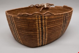
work basket
https://search.heritageburnaby.ca/link/museumartifact80211
- Repository
- Burnaby Village Museum
- Accession Code
- BV009.1.2
- Description
- Oval shaped coiled cedar root basket with cedar slat foundation. Overcast rim with remnants of a loopwork border. Decorated with vertical stripes of imbricated designs in canary grass and black dyed cherry bark. Cherry bark can be distinguished by the small eyes in the surface of the bark. If the basket maker is skilled the bark has a shiny appearance, if it has not been scraped properly it has a greyish tinge. Canary grass is differentiated from cattail and bear grass by its shiny appearance according to a Stó:lō/Stl’atl’imx elder and basket maker from Mount Currie, who was married into Upper Sḵwx̱wú7mesh.
- Object History
- Basket, ca. 1895-1910, from the collection of the L. Claude Hill family, who owned the property that became the Burnaby Village Museum. According to the Hill family, L. Claude's wife Anne Sarah Hill (nee Kendrick) traded blankets for baskets, although it is not known if this particular basket was obtained in this manner. Indigenous people travelled the trail that crossed Deer Lake Brook (Douglas Road / Canada Way).
- Measurements
- Measurements: width 31.5 cm and length 51.5 cm and depth 19.5 cm all measured from top edge to outside of basket, not including trim.
- Country Made
- Canada
- Province Made
- British Columbia
- School/Style
- Coast Salish
- Culture
- First Nations
Images
