Narrow Results By

date plaque
https://search.heritageburnaby.ca/link/museumartifact90987
- Repository
- Burnaby Village Museum
- Accession Code
- BV021.11.1
- Description
- Bronze date plaque stamped "F.V.M.P.A./ BURNABY PLANT SOD TURNING / JULY 26, 1962" with 4 corner holes. The object has scratches throughout. The plaque is taped to a cardboard tag with the text "B5102 / $0.80"
- Object History
- The plate is to commemorate the Fraser Valley Milk Producers Assocation Burnaby Plant sod turning ceremony on July 26, 1962, when construction started on the new facility at Sperling and Lougheed. The plant opened in 1964, and housed the FVMPA head offices, fluid milk plant, and ice cream manufacturing division.
- Category
- 08. Communication Artifacts
- Classification
- Documentary Artifacts - - Other Documents
- Object Term
- Plate, Identification
- Measurements
- 6.3cm wide x 3.1cm high
- Subjects
- Foods
- Agriculture
- Agriculture - Dairy
- Historic Neighbourhood
- Lozells (Historic Neighbourhood)
- Planning Study Area
- Government Road Area
Images

![Planning Map of Chinese Market Gardens on Marine Drive, [between 1950 and 1959] (date of original), 2017 (date of duplication) thumbnail](/media/hpo/_Data/_BVM_Images/2017/2017_0040_0002_001.jpg?width=280)
Planning Map of Chinese Market Gardens on Marine Drive
https://search.heritageburnaby.ca/link/museumdescription4297
- Repository
- Burnaby Village Museum
- Date
- [between 1950 and 1959] (date of original), 2017 (date of duplication)
- Collection/Fonds
- Herbert Yee Law family fonds
- Description Level
- Item
- Physical Description
- 1 photograph (tiff) : col. ; 300 dpi
- Scope and Content
- Scanned copy of a survey plan of district lots 163, 162, 157, 158, and 165, near the Chinese Market Gardens along Marine Drive.
- Repository
- Burnaby Village Museum
- Collection/Fonds
- Herbert Yee Law family fonds
- Description Level
- Item
- Physical Description
- 1 photograph (tiff) : col. ; 300 dpi
- Scope and Content
- Scanned copy of a survey plan of district lots 163, 162, 157, 158, and 165, near the Chinese Market Gardens along Marine Drive.
- History
- Survey plan of district lots 163, 162, 157, 158, and 165, which is primarily the area farmed by Chinese and Chinese-Canadian market gardeners around Marine Drive between Royal Oak and Mandeville (present-day Nelson). Two Chinese/Chinese Canadian land owners can be seen on the map: N.G. Wah Sing (or Ng Wah Sing) and Yee Law (or Herbert Law).
- Geographic Access
- Marine Drive
- Accession Code
- BV017.40.2
- Access Restriction
- No restrictions
- Reproduction Restriction
- No known restrictions
- Date
- [between 1950 and 1959] (date of original), 2017 (date of duplication)
- Media Type
- Cartographic Material
- Historic Neighbourhood
- Fraser Arm (Historic Neighbourhood)
- Planning Study Area
- Big Bend Area
- Scan Resolution
- 300
- Scan Date
- 11/19/2017
- Scale
- 100
- Notes
- Title based on contents of copy scan of map
- Herbert Yee Law was donor's father and this map may have originally been his copy of the city planning/engineering documents.
Images
![Planning Map of Chinese Market Gardens on Marine Drive, [between 1950 and 1959] (date of original), 2017 (date of duplication) thumbnail](/media/hpo/_Data/_BVM_Images/2017/2017_0040_0002_001.jpg)
tape measure
https://search.heritageburnaby.ca/link/museumartifact90960
- Repository
- Burnaby Village Museum
- Accession Code
- BV021.10.1
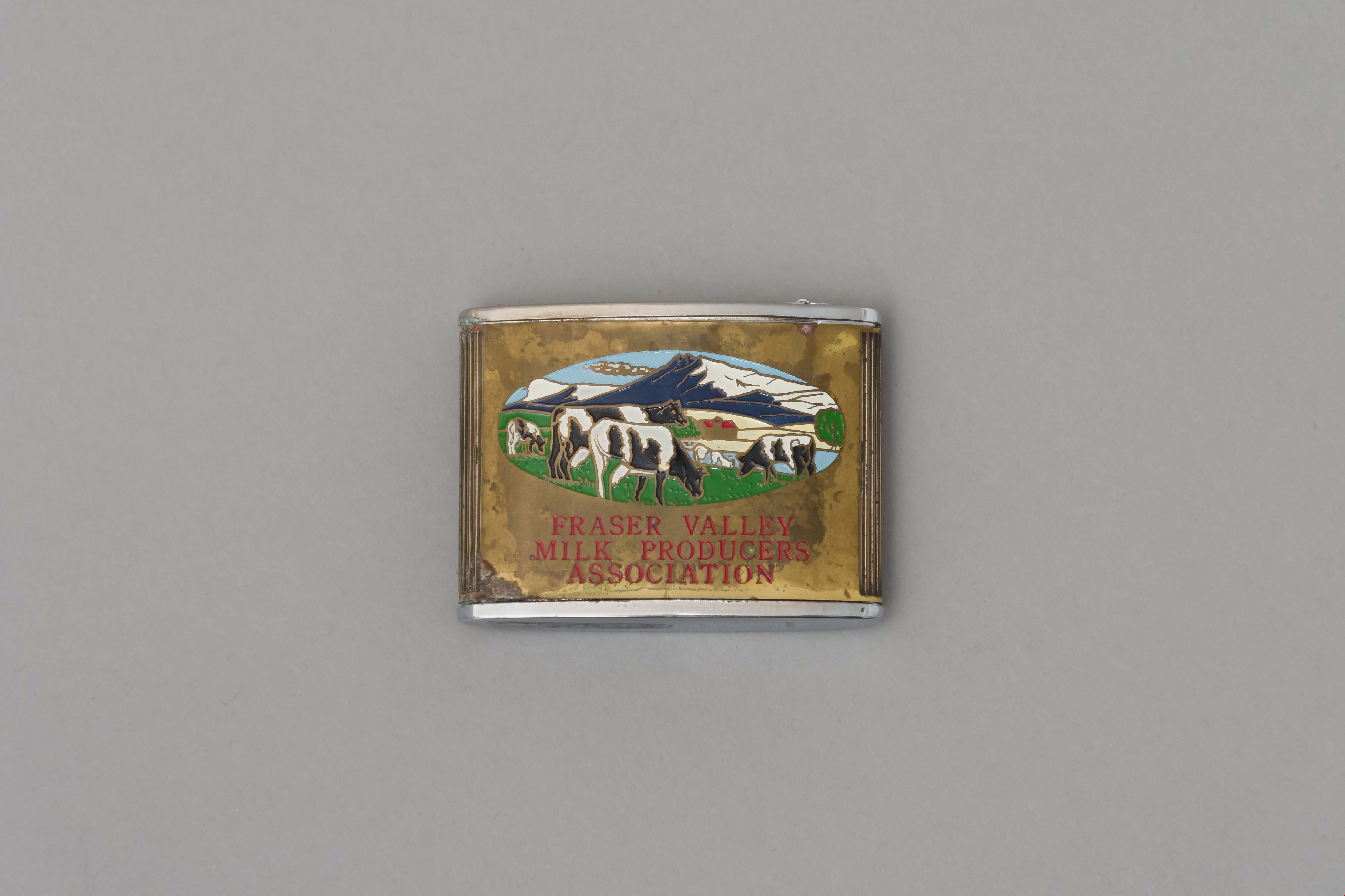
- Description
- Promitional tape measurer with a silver top plates and a gold body engraved on both sides. One side dark blue with ariel drawing of building and "Dairyland/ BURNABY PLANT/ 1964" engraved. Reverse is oval image of 4 cows in a field with mountains, sky, and a barn painted on a gold body with "FRASER VALLEY/ MILK PRODUCERS/ ASSOCIATION" in red. Top has a retractable silver steel tape with measurements in inches on one side. "Japan" engraved on base.
- Object History
- This object belonged to a sales representative for Dairyland, who lived in Chilliwack. He retired in 1978 after 40 years with the company. The Burnaby Dairyland plant was constructed in 1964 on Lougheed Highway near Sperling Avenue.
- Reference
- http://www.bcdairyhistory.ca/milk-break/magazine/1964-fraser-valley-milk-break.pdf
- Classification
- Weights and Measurements Tools and Equipment - Scales
- Object Term
- Retractable Rule, Tape Measure
- Marks/Labels
- "Dairyland Burnaby Plant 1964", "Fraser Valley Milk Producers Association" "Japan"
- Measurements
- 4cm high x 5cm wide
- Subjects
- Foods
- Agriculture
- Agriculture - Dairy
- Historic Neighbourhood
- Lozells (Historic Neighbourhood)
- Planning Study Area
- Government Road Area
Images