Narrow Results By
Person / Organization
- Bridge Studios 1
- British Columbia Electric Railway 2
- British Columbia Electric Railway Company 2
- British Columbia Mills Timber and Trading Company 1
- Brown, Donald N. "Don" 1
- Burnaby Lawn Bowling Club 1
- Burnaby Village Museum
- Central Park Provincial Park Board 1
- Century Park Museum Association 1
- Ceperley, Grace 2
- Ceperley, H.T.
- Chow, Hipman "Jimmy" 1

H.T. Ceperley Estate 'Fairacres' Estate Gate
https://search.heritageburnaby.ca/link/landmark863
- Repository
- Burnaby Heritage Planning
- Description
- The 'Fairacres Estate Gate' marks the location of one of the original driveway entrances to the estate.
- Associated Dates
- 1911
- Formal Recognition
- Heritage Designation, Community Heritage Register
- Street View URL
- Google Maps Street View
- Repository
- Burnaby Heritage Planning
- Geographic Access
- Deer Lake Avenue
- Associated Dates
- 1911
- Formal Recognition
- Heritage Designation, Community Heritage Register
- Enactment Type
- Bylaw No. 140665
- Enactment Date
- 23/11/1992
- Description
- The 'Fairacres Estate Gate' marks the location of one of the original driveway entrances to the estate.
- Heritage Value
- Fairacres was designed as a country estate with a working farm that included over 10 acres of productive berry and vegetable fields, with a large kitchen garden, a root house to store food, and greenhouses heated by steam. The agricultural potential ofthe Deer Lake area made it one of the first parts of the municipality to attract settlement. Construction of the Fairacres Estate represented a shift toward wealthy country estates over more modest farms, and the Ceperleys employed a large staff to manage the estate's agricultural production. Agricultural use of the estate continued when a Catholic order of Benedictine monks purchased the estate as part of the Priory of St. Joseph and the Seminary of Christ the King, and continued to farm the land until 1953. The overall architectural intention of the estate's architect was to reflect the ideals of the Arts & Crafts movement to showcase craftsmanship, and to incorporate high quality materials, including many local materials, such as wood and stone from the site. On the mansion exterior, the rustic style is seen in the use of natural materials such as cedar shingles and siding, cobblestone foundations and chimneys and the half-timbering in gable ends. The estate's remaining gate pillar features the same rustic field and cobblestones used on the mansion. The original estate driveway had two entrances constructed in 1910, each marked by a pair of entry gate pillars which supported iron gates. The main entrance gate pillars which marked the lower driveway and the east pillar of the upper entrance were demolished many years ago and the iron gates removed. A single gate pillar remains marking the upper driveway, adjacent to the Garage and Stables. This gate pillar is a significant site feature and incorporates cobble stone and a carved sandstone capstone.
- Defining Elements
- Key elements that define the heritage character of the ‘Fairacres Estate Gate' include: - setting in relation to the estate boundary and estate buildings - Cobble stone and sandstone construction, which represents a typical Arts and Crafts use of local materials, and matches the extensive use of cobblestone as chimneys and foundations on the Fairacres mansion, as well as the use of sandstone on the mansion's exterior.
- Locality
- Deer Lake Park
- Historic Neighbourhood
- Burnaby Lake (Historic Neighbourhood)
- Planning Study Area
- Douglas-Gilpin Area
- Function
- Primary Historic--Estate
- Community
- Burnaby
- Cadastral Identifier
- P.I.D. No. 004-493-311 Legal Description: Block 3 Except: Part subdivided by Plan 26865, District Lot 79, Group 1, New Westminster District, Plan 536
- Boundaries
- ‘Fairacres’ is comprised of a single municipally-owned property located at 6344 Deer Lake Avenue, Burnaby.
- Area
- 17,065.00
- Contributing Resource
- Landscape Feature
- Ownership
- Public (local)
- Other Collection
- Burnaby Historical Society, Community Archives: Ceperley Photograph Album
- Documentation
- Heritage Site Files: PC77000 20. City of Burnaby Planning and Building Department, 4949 Canada Way, Burnaby, B.C., V5G 1M2
- Subjects
- Structures - Fences
- Street Address
- 6344 Deer Lake Avenue
- Street View URL
- Google Maps Street View
Images


H.T. Ceperley Estate 'Fairacres' Greenhouse Foundation Wall
https://search.heritageburnaby.ca/link/landmark862
- Repository
- Burnaby Heritage Planning
- Description
- The original rubble stone walls that formed the foundation for a greenhouses adjacent to the Steam Plant Building provided heat to several greenhouses on the estate propoerty. The Root House, which is to the north of the Greenhouse Foundation Wall, provided storage for the farm operation.
- Associated Dates
- 1908
- Formal Recognition
- Heritage Designation, Community Heritage Register
- Repository
- Burnaby Heritage Planning
- Geographic Access
- Deer Lake Avenue
- Associated Dates
- 1908
- Formal Recognition
- Heritage Designation, Community Heritage Register
- Enactment Type
- Bylaw No. 140665
- Enactment Date
- 23/11/1992
- Description
- The original rubble stone walls that formed the foundation for a greenhouses adjacent to the Steam Plant Building provided heat to several greenhouses on the estate propoerty. The Root House, which is to the north of the Greenhouse Foundation Wall, provided storage for the farm operation.
- Heritage Value
- The outbuildings at 'Fairacres' are a rare surviving architecturally-designed ensemble of agricultural structures that exist in complementary harmony with the main estate house. Architect Robert Mackay Fripp (1858-1917), an outspoken advocate of Arts and Crafts design, was retained by the Ceperleys to design several original outbuildings on their estate, which was designed as a country estate with a working farm that included over 10 acres of productive berry and vegetable fields, with a large kitchen garden, a root house to store food, an orchard, and greenhouses heated by steam. The agricultural potential of the Deer Lake area made it one of the first parts of the municipality to attract settlement. In 1909, the Ceperleys built three large greenhouses heated by an adjacent steam plant (Fairacres Steam Plant). The greenhouses featured granite foundation walls, including this one which remains intact. The Ceperleys employed a large staff to manage the estate's agricultural production, including Chinese farm labourers. Produce was grown for use at the estate, and for sale at local markets. Agricultural use of the estate continued when a Catholic order of Benedictine monks purchased the estate as part of the Priory of St. Joseph and the Seminary of Christ the King, and continued to farm the land until 1953.
- Defining Elements
- Key elements that define the heritage character of the ‘Fairacres’ Steam Plant Building include its: - overall spatial arrangement of the Greenhouse Foundation Wall in relation to the Steam Plant Building and the Root House - original rubble stone walls reflecting the Arts and Crafts design aesthetic of the estate buildings.
- Locality
- Deer Lake Park
- Historic Neighbourhood
- Burnaby Lake (Historic Neighbourhood)
- Planning Study Area
- Douglas-Gilpin Area
- Architect
- Robert Mackay Fripp
- Function
- Primary Historic--Outbuilding
- Community
- Burnaby
- Cadastral Identifier
- P.I.D. No. 004-493-311 Legal Description: Block 3 Except: Part subdivided by Plan 26865, District Lot 79, Group 1, New Westminster District, Plan 536
- Boundaries
- ‘Fairacres’ is comprised of a single municipally-owned property located at 6344 Deer Lake Avenue, Burnaby.
- Area
- 17,065.00
- Contributing Resource
- Landscape Feature
- Remains
- Ownership
- Public (local)
- Other Collection
- Burnaby Historical Society, Community Archives: Ceperley Photograph Album
- Documentation
- Heritage Site Files: PC77000 20. City of Burnaby Planning and Building Department, 4949 Canada Way, Burnaby, B.C., V5G 1M2
- Street Address
- 6344 Deer Lake Avenue
Images


Vorce Station
https://search.heritageburnaby.ca/link/landmark664
- Repository
- Burnaby Heritage Planning
- Description
- The Vorce Station is a modest utilitarian passenger tram shelter, originally constructed at the foot of Nursery Street as part of the British Columbia Electric Railway Company’s Burnaby Lake Interurban Line. In 1953, it was moved to a local farm by the Lubbock family, and in 1977 it was relocated t…
- Associated Dates
- 1911
- Formal Recognition
- Heritage Designation, Community Heritage Register
- Repository
- Burnaby Heritage Planning
- Geographic Access
- Deer Lake Avenue
- Associated Dates
- 1911
- Formal Recognition
- Heritage Designation, Community Heritage Register
- Enactment Type
- Bylaw No. 9807
- Enactment Date
- 23/11/1992
- Description
- The Vorce Station is a modest utilitarian passenger tram shelter, originally constructed at the foot of Nursery Street as part of the British Columbia Electric Railway Company’s Burnaby Lake Interurban Line. In 1953, it was moved to a local farm by the Lubbock family, and in 1977 it was relocated to Burnaby Village Museum. The wood-frame structure has a rectangular plan and hipped roof. It is enclosed on three sides, with an open side for access to the train platform and a single long built-in bench across the back of the station.
- Heritage Value
- The heritage value of the Vorce Station is as the last remaining interurban station in Burnaby and one of the few extant structures left in the Greater Vancouver region that were once part of the extensive British Columbia Electric Railway (BCER) interurban system. The Vorce Station was designed and built by the BCER, and is typical of the small local passenger stations on the Burnaby Lake and Chilliwack interurban lines. It was named after C.B. Vorce, the Chief Engineer for the company. The impact of the interurban line on local development was extremely significant, as it connected the cities of New Westminster and Vancouver, and enabled the residents of Burnaby to form a cohesive municipality from the mainly rural lands remaining between the two larger centres. Much of the early development in Burnaby was due to the growth of the interurban rail lines. The heritage significance for this station also lies in its interpretive value within the Burnaby Village Museum. The Vorce Station is an important cultural feature for the interpretation of Burnaby’s transportation history to the public, and is an important surviving feature of the BCER interurban system.
- Defining Elements
- The character defining features of the Vorce Station include its: - rectangular form and pyramidal roof with overhanging eaves - simple vernacular design and utilitarian nature - cedar shingle wall cladding - cedar shingle-clad roof with galvanized pressed tin roof ridges - interior vertical tongue-and-groove panelling - heritage graffiti: initials and messages carved and scrawled on the walls - identifying sign with large letters visible at a distance
- Locality
- Deer Lake Park
- Historic Neighbourhood
- Burnaby Lake (Historic Neighbourhood)
- Planning Study Area
- Morley-Buckingham Area
- Organization
- British Columbia Electric Railway
- Burnaby Village Museum
- Function
- Primary Current--Museum
- Primary Historic--Rail Station
- Community
- Burnaby
- Cadastral Identifier
- P.I.D. No. 011-030-356 Legal Description: Parcel 1, District Lot 79 and District Lot 85, Group 1, New Westminster District, Reference Plan 77594
- Boundaries
- Burnaby Village Museum is comprised of a single municipally-owned property located at 6501 Deer Lake Avenue, Burnaby.
- Area
- 38,488.63
- Contributing Resource
- Building
- Structure
- Landscape Feature
- Documentation
- Heritage Site Files: PC77000 20. City of Burnaby Planning and Building Department, 4949 Canada Way, Burnaby, B.C., V5G 1M2
- Street Address
- 6501 Deer Lake Avenue
Images


notice
https://search.heritageburnaby.ca/link/museumartifact91020
- Repository
- Burnaby Village Museum
- Accession Code
- BV020.5.1667
- Description
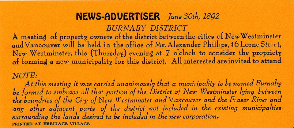
- Notice; printed with black text on orange cardstock; Text reads from top to bottom: "NEWS -ADVERTISER June 30th, 1892 / BURNABY DISTRICT / A meeting of property owners of the district between the cities of New Westminster and Vancouver will be held in the offic eof Mr. Alexander Phillips, 56 Lorne Street, / New Westminster, this (Thursday) evening at 7 o'clock to consider the propriety / of forming a new municipality for this district. All interested are invited to attend / NOTE: / At this meeting it was carried unamiously that a municipality to be named Burnaby / be formed to embrace all that portion of the District of New Westminster lying between / the boundaries of the City of New Westminster and Vancouver and the Fraser Rive and / any other adjacent parts of the district not included in the existing municipalities / surrounding the lands desired to be included in the new corporation. / PRINTED AT HERITAGE VILLAGE". [ca. 1972]
- Object History
- Part of the Century Park Museum Association ephemera collection. Notice was printed in the Heritage Village Print Shop and handed out to visitors in the 1970s.
- Category
- 08. Communication Artifacts
- Classification
- Documentary Artifacts - - Other Documents
- Object Term
- Serial
- Colour
- Orange
- Black
- Measurements
- L: 23 cm x H: 10 cm
- Maker
- Heritage Village
- Country Made
- Canada
- Province Made
- British Columbia
- Site/City Made
- Burnaby
- Subjects
- Documentary Artifacts - Posters
Images