More like 'Ski trail on Mount Seymour'
Narrow Results By
Subject
- Accidents 4
- Accidents - Automobile Accidents 2
- Advertising Medium - Signs and Signboards 20
- Aerial Photographs 34
- Agricultural Tools and Equipment 2
- Agricultural Tools and Equipment - Gardening Equipment 4
- Agricultural Tools and Equipment - Plows 2
- Agriculture 2
- Agriculture - Farms 11
- Agriculture - Fruit and Berries 2
- Animals 4
- Animals - Bears 2
![Snowplough on Barkerville Highway, [1938] thumbnail](/media/hpo/_Data/_Archives_Images/_Unrestricted/001/020-155.jpg?width=280)
Snowplough on Barkerville Highway
https://search.heritageburnaby.ca/link/archivedescription34448
- Repository
- City of Burnaby Archives
- Date
- [1938]
- Collection/Fonds
- Burnaby Historical Society fonds
- Description Level
- Item
- Physical Description
- 1 photograph : b&w ; 13.9 x 18.9 cm on page 17.5 x 26 cm
- Scope and Content
- Photograph has the following caption: "First rotary snowplough working on Barkerville Highway, Devil's Canyon."
- Repository
- City of Burnaby Archives
- Date
- [1938]
- Collection/Fonds
- Burnaby Historical Society fonds
- Subseries
- Peers family subseries
- Physical Description
- 1 photograph : b&w ; 13.9 x 18.9 cm on page 17.5 x 26 cm
- Description Level
- Item
- Record No.
- 020-155
- Access Restriction
- No restrictions
- Reproduction Restriction
- No known restrictions
- Accession Number
- BHS2007-04
- Scope and Content
- Photograph has the following caption: "First rotary snowplough working on Barkerville Highway, Devil's Canyon."
- Media Type
- Photograph
- Notes
- Title based on caption accompanying photograph
Images
![Snowplough on Barkerville Highway, [1938] thumbnail](/media/hpo/_Data/_Archives_Images/_Unrestricted/001/020-155.jpg)
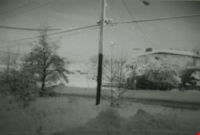
Snowy neighbourhood
https://search.heritageburnaby.ca/link/archivedescription38005
- Repository
- City of Burnaby Archives
- Date
- January 1972 (date of original), copied 1991
- Collection/Fonds
- Burnaby Historical Society fonds
- Description Level
- Item
- Physical Description
- 1 photograph : b&w ; 3.2 x 4.7 cm print on contact sheet 20.5 x 26.4 cm
- Scope and Content
- Photograph of a snowy neighbourhood at sunrise. MacPherson Junior High School is visible in the background.
- Repository
- City of Burnaby Archives
- Date
- January 1972 (date of original), copied 1991
- Collection/Fonds
- Burnaby Historical Society fonds
- Subseries
- Burnaby Image Bank subseries
- Physical Description
- 1 photograph : b&w ; 3.2 x 4.7 cm print on contact sheet 20.5 x 26.4 cm
- Description Level
- Item
- Record No.
- 370-592
- Access Restriction
- No restrictions
- Reproduction Restriction
- No restrictions
- Accession Number
- BHS1999-03
- Scope and Content
- Photograph of a snowy neighbourhood at sunrise. MacPherson Junior High School is visible in the background.
- Media Type
- Photograph
- Notes
- Title based on contents of photograph
- 1 b&w copy negative accompanying
- Copied from col. photograph
- Annotation at bottom of photograph reads, "Jan. Sunrise 1972"
- Geographic Access
- Rumble Street
- MacPherson Avenue
- Historic Neighbourhood
- Alta-Vista (Historic Neighbourhood)
- Planning Study Area
- Clinton-Glenwood Area
Images

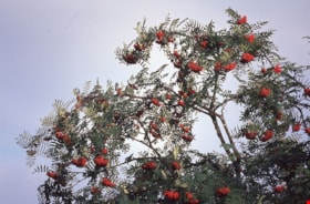
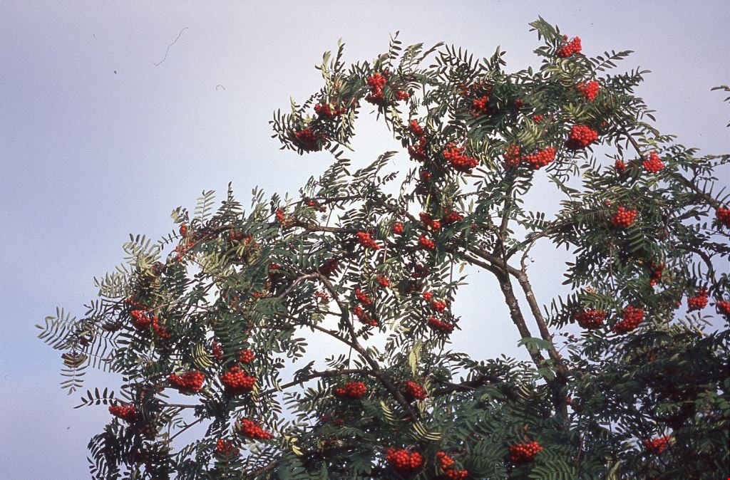
Still Creek Flora
https://search.heritageburnaby.ca/link/archivedescription91703
- Repository
- City of Burnaby Archives
- Date
- 1991
- Collection/Fonds
- Doreen Lawson fonds
- Description Level
- File
- Physical Description
- 6 photographs : col. slides ; 35 mm
- Scope and Content
- File consists photographs of colourful flora around Still Creek. Flower species have not been identified.
- Repository
- City of Burnaby Archives
- Date
- 1991
- Collection/Fonds
- Doreen Lawson fonds
- Physical Description
- 6 photographs : col. slides ; 35 mm
- Description Level
- File
- Record No.
- 618-021
- Access Restriction
- No restrictions
- Reproduction Restriction
- No restrictions
- Accession Number
- 2015-15
- Scope and Content
- File consists photographs of colourful flora around Still Creek. Flower species have not been identified.
- Subjects
- Geographic Features - Lakes and Ponds
- Animals - Birds
- Plants - Trees
- Natural Phenomena - Snow
- Media Type
- Photograph
- Photographer
- Lawson, Doreen A.
- Notes
- Transcribed title
- Title transcribed from slide sheet
- Note purple and blue ink on original slide sheet read: "Still Creek / Flora / 1991"
- Geographic Access
- Still Creek
- Historic Neighbourhood
- Burnaby Lake (Historic Neighbourhood)
Images

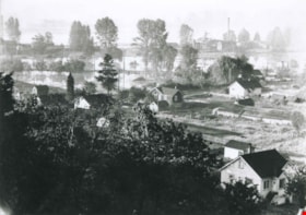
Venables Street panorama
https://search.heritageburnaby.ca/link/archivedescription52573
- Repository
- City of Burnaby Archives
- Date
- 1975
- Collection/Fonds
- Harold H. Johnston fonds
- Description Level
- Item
- Physical Description
- 1 photograph (jpeg) : b&w
- Scope and Content
- Photograph is a panorama of Venables Street after a snowfall. The photograph was taken outside of the Johnston family home at 4447 Venables Street (which can be seen at centre).
- Repository
- City of Burnaby Archives
- Date
- 1975
- Collection/Fonds
- Harold H. Johnston fonds
- Physical Description
- 1 photograph (jpeg) : b&w
- Description Level
- Item
- Record No.
- 483-096
- Access Restriction
- No restrictions
- Reproduction Restriction
- No reproduction permitted
- Accession Number
- 2008-08
- Scope and Content
- Photograph is a panorama of Venables Street after a snowfall. The photograph was taken outside of the Johnston family home at 4447 Venables Street (which can be seen at centre).
- Media Type
- Photograph
- Photographer
- Johnston, Harold H.
- Notes
- Title based on contents of photograph
- Geographic Access
- Venables Street
- Street Address
- 4447 Venables Street
- Historic Neighbourhood
- Vancouver Heights (Historic Neighbourhood)
- Planning Study Area
- Willingdon Heights Area
Images

![Walk in the snow, [2000] thumbnail](/media/hpo/_Data/_Archives_Images/_Unrestricted/535/535-3056.jpg?width=280)
Walk in the snow
https://search.heritageburnaby.ca/link/archivedescription97930
- Repository
- City of Burnaby Archives
- Date
- [2000]
- Collection/Fonds
- Burnaby NewsLeader photograph collection
- Description Level
- Item
- Physical Description
- 1 photograph (tiff) : col.
- Scope and Content
- Photograph of three unidentified people walking over a bridge in a park, surrounded by snow and trees.
- Repository
- City of Burnaby Archives
- Date
- [2000]
- Collection/Fonds
- Burnaby NewsLeader photograph collection
- Physical Description
- 1 photograph (tiff) : col.
- Description Level
- Item
- Record No.
- 535-3056
- Access Restriction
- No restrictions
- Reproduction Restriction
- No restrictions
- Accession Number
- 2018-12
- Scope and Content
- Photograph of three unidentified people walking over a bridge in a park, surrounded by snow and trees.
- Media Type
- Photograph
- Notes
- Title based on contents of the photograph
- Collected by editorial for use in a January 2000 issue of the Burnaby NewsLeader
Images
![Walk in the snow, [2000] thumbnail](/media/hpo/_Data/_Archives_Images/_Unrestricted/535/535-3056.jpg)
![Slush in New Westminster, [2000] thumbnail](/media/hpo/_Data/_Archives_Images/_Unrestricted/535/535-1606-1.jpg?width=280)
Slush in New Westminster
https://search.heritageburnaby.ca/link/archivedescription95748
- Repository
- City of Burnaby Archives
- Date
- [2000]
- Collection/Fonds
- Burnaby NewsLeader photograph collection
- Description Level
- File
- Physical Description
- 4 photographs (tiff) : col.
- Scope and Content
- File contains photographs of the aftermath of a snow and rain storm in New Westminster. Photographs depict pedestrians stepping through, navigating, and shovelling large amounts of slush on the city streets.
- Repository
- City of Burnaby Archives
- Date
- [2000]
- Collection/Fonds
- Burnaby NewsLeader photograph collection
- Physical Description
- 4 photographs (tiff) : col.
- Description Level
- File
- Record No.
- 535-1606
- Access Restriction
- No restrictions
- Reproduction Restriction
- No restrictions
- Accession Number
- 2018-12
- Scope and Content
- File contains photographs of the aftermath of a snow and rain storm in New Westminster. Photographs depict pedestrians stepping through, navigating, and shovelling large amounts of slush on the city streets.
- Media Type
- Photograph
- Photographer
- Bartel, Mario
- Notes
- Title based on caption
- Collected by editorial for use in a December 2000 issue of the Burnaby NewsLeader
- Caption from metadata for 535-1606-1: "The mural at Sixth and Blackford Streets in New West seems to be taking great delight in the misery of pedestrians as they negotiate the heavy slush and water left behind by Saturday's snow and rain storm."
- Caption from metadata for 535-1606-2: "Al Hoegler, who owns the Westminster Deli, clears the storm drain in front of his store in an attempt to relieve the flooding."
- Caption from metadata for 535-1606-3: "Pedestrians walking in uptown New West had to tread carefully to avoid water and slush puddles left behind by Saturday's snow and rain storm."
- Caption from metadata for 535-1606-4: "A window display on Sixth St. advertising Carribean cruises beckons pedestrians in uptown New West as they trudge through Saturday's snow and rain storm."
Images
![Slush in New Westminster, [2000] thumbnail](/media/hpo/_Data/_Archives_Images/_Unrestricted/535/535-1606-1.jpg)
![Family in foggy Central Park, [1999] thumbnail](/media/hpo/_Data/_Archives_Images/_Unrestricted/535/535-3118-1.jpg?width=280)
Family in foggy Central Park
https://search.heritageburnaby.ca/link/archivedescription98038
- Repository
- City of Burnaby Archives
- Date
- [1999]
- Collection/Fonds
- Burnaby NewsLeader photograph collection
- Description Level
- File
- Physical Description
- 2 photographs (tiff) : col.
- Scope and Content
- File contains photographs of an unidentified family in Central Park in the fog. The photographs depict sun coming through the trees and the fog and the family, in silhouette, by water with ducks.
- Repository
- City of Burnaby Archives
- Date
- [1999]
- Collection/Fonds
- Burnaby NewsLeader photograph collection
- Physical Description
- 2 photographs (tiff) : col.
- Description Level
- File
- Record No.
- 535-3118
- Access Restriction
- No restrictions
- Reproduction Restriction
- No restrictions
- Accession Number
- 2018-12
- Scope and Content
- File contains photographs of an unidentified family in Central Park in the fog. The photographs depict sun coming through the trees and the fog and the family, in silhouette, by water with ducks.
- Subjects
- Persons - Families
- Geographic Features - Parks
- Geographic Features - Lakes and Ponds
- Natural Phenomena
- Names
- Central Park
- Media Type
- Photograph
- Photographer
- Bartel, Mario
- Notes
- Title based on caption
- Collected by editorial for use in a December 1999 issue of the Burnaby NewsLeader
- Caption from metadata: "The dense fog that blanketed the Lower Mainland for more than a week creates an eerie beauty at Central Park."
- Geographic Access
- Central Park
- Imperial Street
- Street Address
- 3883 Imperial Street
- Historic Neighbourhood
- Central Park (Historic Neighbourhood)
- Planning Study Area
- Maywood Area
Images
![Family in foggy Central Park, [1999] thumbnail](/media/hpo/_Data/_Archives_Images/_Unrestricted/535/535-3118-1.jpg)
Interview with John Templeton, Alan James and Christine Leston by Kathy Bossort October 26, 2015 - Track 9
https://search.heritageburnaby.ca/link/oralhistory595
- Repository
- City of Burnaby Archives
- Date Range
- 1995-2015
- Length
- 0:12:28
- Summary
- This portion of the interview is about the Stoney Creek Environment Committee members’ discussion of how the history of the forest and natural area on Burnaby Mountain forms part of our appreciation for the mountain. They talk about the impact of the conservation area on adjacent urban areas such a…
- Repository
- City of Burnaby Archives
- Summary
- This portion of the interview is about the Stoney Creek Environment Committee members’ discussion of how the history of the forest and natural area on Burnaby Mountain forms part of our appreciation for the mountain. They talk about the impact of the conservation area on adjacent urban areas such as the neighbourhood of Forest Grove, and the future of the urban forest on Burnaby Mountain.
- Date Range
- 1995-2015
- Length
- 0:12:28
- Geographic Access
- Burnaby Mountain Conservation Area
- Stoney Creek
- Interviewer
- Bossort, Kathy
- Interview Date
- October 26, 2015
- Scope and Content
- Recording is of an interview with John Templeton, Alan James & Christine Leston, members of the Stoney Creek Environment Committee, conducted by Kathy Bossort. The three members of SCEC were among 23 participants interviewed as part of the Community Heritage Commission’s Burnaby Mountain Oral History Project. The interview is mainly about the history and work of the stream keeper group Stoney Creek Environment Committee (SCEC) and the Stoney Creek Environmental Working Group, and about SCEC’s founder Jennifer Atkinson. The interview is made richer by the complementary views of the three interviewees, John Templeton (SCEC Chair), Alan James (Member-at-Large - Education), and Christine Leston (Treasurer).
- Biographical Notes
- The Stoney Creek Environment Committee is a streamkeeper group and registered non-profit society dedicated to protecting and restoring viable salmon-bearing streams within the Stoney Creek Watershed. (Stoney Creek originates on Burnaby Mountain and is part of the Brunette watershed which empties into the Fraser River.) The volunteer group, formed in 1995, was guided by the tireless efforts of Jennifer Atchison (1938-2010) after whom the Jennifer Atchison Environmental Centre in North Burnaby is named. The volunteer members of SCEC monitor water quality, generate inventories and reports on the biophysical assets and health of the watershed, provide educational opportunities, enhance stream and stream bank habitat, and speak on behalf of the Stoney Creek watershed. One of its key events is The Great Salmon Send-Off, the release of young salmon into Stoney Creek in May, which celebrated its 25th anniversary in 2015. The Stoney Creek Environmental Working Group (1999-present), managed by the City of Burnaby, undertakes to coordinate the actions of all stakeholders in the Stoney Creek watershed. It is comprised of representatives from community groups, such as SCEC, governmental and institutional agencies, and industries who are committed to sustaining and improving the quality of the Stoney Creek watershed’s water, wildlife and environment. John Templeton, currently SCEC Chair, joined SCEC in 2004. He was born in Coleraine ,County Londonderry, Northern Ireland, in 1957, and after immigrating to Canada, came to live in Burnaby in 1992, first in Forest Grove (1992-2014) and then in Forest Hills. He works as a millwright. Alan James,Member-at-large - Education, joined SCEC in 2003 He was born in 1939 in Berkeley, California, and came to live in Burnaby in about 2000. He is a retired geophycisist and computer consultant. Christine Leston joined SCEC in 1997, serving first as Secretary and then as Treasurer. She was born in 1943 in Cheshire, England, and came to live in Burnaby in 1974, first in Greentree Village, then Simon Fraser Village (1974-2004) and now the Edmonds area. She is a retired technical writer.
- Total Tracks
- 9
- Total Length
- 2:08:27
- Interviewee Name
- Templeton, John R.
- James, Alan C.
- Leston, Christine
- Interview Location
- Jennifer Atchison Environmental Centre, Burnaby
- Interviewer Bio
- Kathy Bossort is a retired archivist living in Ladner, BC. She worked at the Delta Museum and Archives after graduating from SLAIS (UBC) in 2001 with Masters degrees in library science and archival studies. Kathy grew up in Calgary, Alberta, and, prior to this career change, she lived in the West Kootenays, earning her living as a cook for BC tourist lodges and work camps. She continues to be interested in oral histories as a way to fill the gaps in the written record and bring richer meaning to history.
- Collection/Fonds
- Community Heritage Commission Special Projects fonds
- Media Type
- Sound Recording
Audio Tracks
Track nine of interview with John Templeton, Alan James & Christine Leston
Track nine of interview with John Templeton, Alan James & Christine Leston
https://search.heritageburnaby.ca/media/hpo/_Data/_Archives_Oral_Histories/_Unrestricted/MSS196-006/MSS196-006_Track_9.mp3![Burnaby Lake morning fog, [2004] thumbnail](/media/hpo/_Data/_Archives_Images/_Unrestricted/535/535-1746-1.jpg?width=280)
Burnaby Lake morning fog
https://search.heritageburnaby.ca/link/archivedescription95995
- Repository
- City of Burnaby Archives
- Date
- [2004]
- Collection/Fonds
- Burnaby NewsLeader photograph collection
- Description Level
- File
- Physical Description
- 2 photographs (tiff) : col.
- Scope and Content
- File contains photographs of Burnaby Lake Park in early morning fog, with people jogging and walking the park.
- Repository
- City of Burnaby Archives
- Date
- [2004]
- Collection/Fonds
- Burnaby NewsLeader photograph collection
- Physical Description
- 2 photographs (tiff) : col.
- Description Level
- File
- Record No.
- 535-1746
- Access Restriction
- No restrictions
- Reproduction Restriction
- No restrictions
- Accession Number
- 2018-12
- Scope and Content
- File contains photographs of Burnaby Lake Park in early morning fog, with people jogging and walking the park.
- Media Type
- Photograph
- Photographer
- Bartel, Mario
- Notes
- Title based on caption
- Collected by editorial for use in a January 2004 issue of the Burnaby NewsLeader
- Caption from metadata for 535-1746-1: "A lone early-morning jogger emerges from the fog that has shrouded Burnaby Lake park, as warm air descends upon the remnants of last week's snow storm, still laying in the fields."
- Caption from metadata for 535-1746-2: "A dog walker is silhouetted agains the fog that shrouds Burnaby Lake Fields, as warmer air descends on the remnants of last week's snow storm."
- Geographic Access
- Burnaby Lake
- Burnaby Lake Regional Nature Park
- Historic Neighbourhood
- Burnaby Lake (Historic Neighbourhood)
- Planning Study Area
- Burnaby Lake Area
Images
![Burnaby Lake morning fog, [2004] thumbnail](/media/hpo/_Data/_Archives_Images/_Unrestricted/535/535-1746-1.jpg)
Byrne Flats flood
https://search.heritageburnaby.ca/link/archivedescription36857
- Repository
- City of Burnaby Archives
- Date
- 1948
- Collection/Fonds
- Burnaby Historical Society fonds
- Description Level
- Item
- Physical Description
- 1 photograph : b&w ; 9 x 12 cm print
- Scope and Content
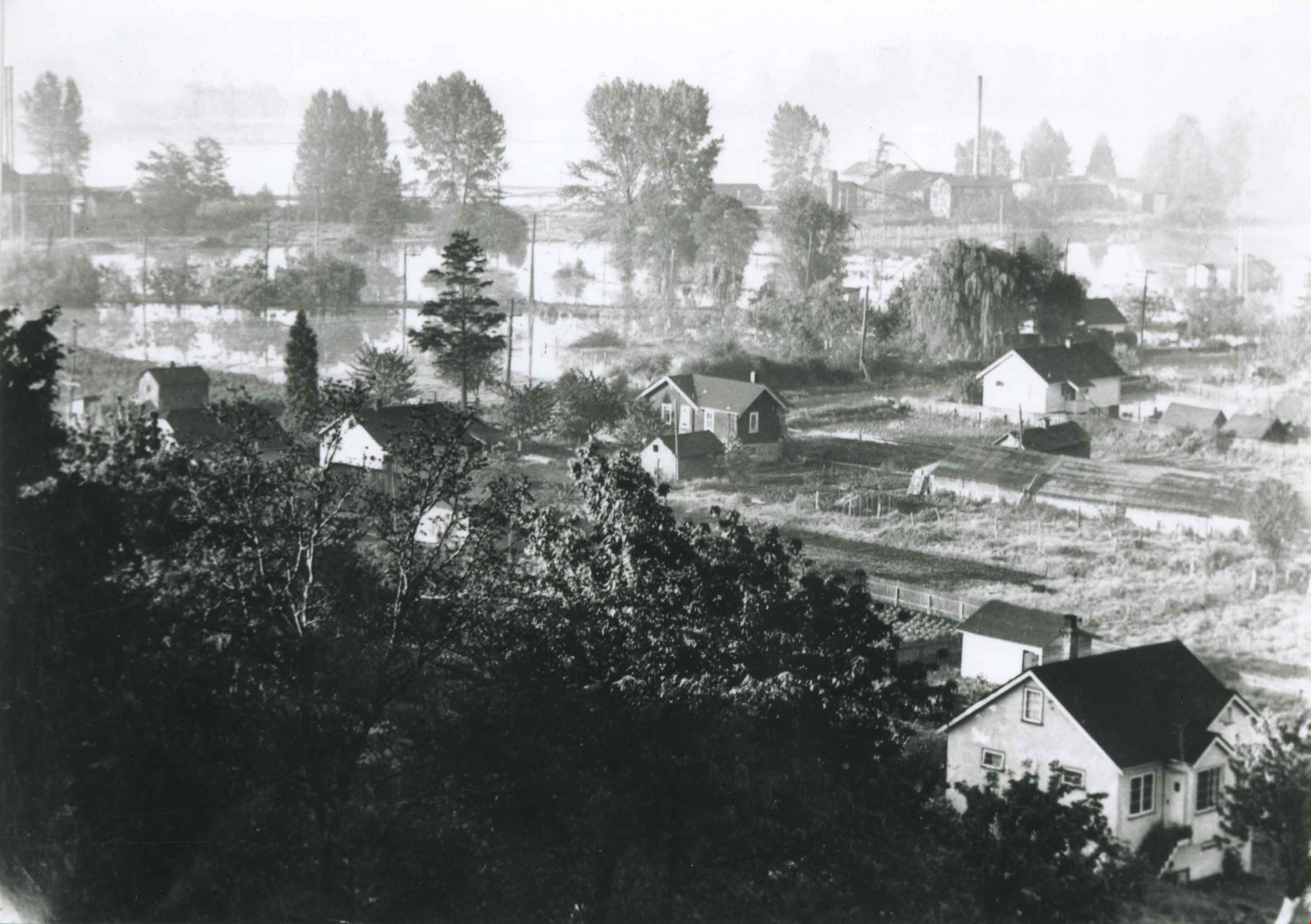
- Photograph of Byrne Flats during the 1948 Fraser River flood.
- Repository
- City of Burnaby Archives
- Date
- 1948
- Collection/Fonds
- Burnaby Historical Society fonds
- Subseries
- Burnaby Centennial Anthology subseries
- Physical Description
- 1 photograph : b&w ; 9 x 12 cm print
- Description Level
- Item
- Record No.
- 315-315
- Access Restriction
- No restrictions
- Reproduction Restriction
- No known restrictions
- Accession Number
- BHS1994-04
- Scope and Content
- Photograph of Byrne Flats during the 1948 Fraser River flood.
- Media Type
- Photograph
- Notes
- Title based on contents of photograph
- Geographic Access
- Trapp Avenue
- Historic Neighbourhood
- Fraser Arm (Historic Neighbourhood)
- Planning Study Area
- Big Bend Area
Images

Byrne Flats flood
https://search.heritageburnaby.ca/link/archivedescription36858
- Repository
- City of Burnaby Archives
- Date
- 1948
- Collection/Fonds
- Burnaby Historical Society fonds
- Description Level
- Item
- Physical Description
- 1 photograph : b&w ; 9 x 12.5 cm print
- Scope and Content
- Photograph of Byrne Flats during the 1948 Fraser River flood.
- Repository
- City of Burnaby Archives
- Date
- 1948
- Collection/Fonds
- Burnaby Historical Society fonds
- Subseries
- Burnaby Centennial Anthology subseries
- Physical Description
- 1 photograph : b&w ; 9 x 12.5 cm print
- Description Level
- Item
- Record No.
- 315-316
- Access Restriction
- No restrictions
- Reproduction Restriction
- No known restrictions
- Accession Number
- BHS1994-04
- Scope and Content
- Photograph of Byrne Flats during the 1948 Fraser River flood.
- Media Type
- Photograph
- Notes
- Title based on contents of photograph
- Geographic Access
- Trapp Avenue
- Historic Neighbourhood
- Fraser Arm (Historic Neighbourhood)
- Planning Study Area
- Big Bend Area
Images

Cottonwood River flood
https://search.heritageburnaby.ca/link/archivedescription34447
- Repository
- City of Burnaby Archives
- Date
- 1937
- Collection/Fonds
- Burnaby Historical Society fonds
- Description Level
- Item
- Physical Description
- 1 photograph : b&w ; 12.3 x 19.7 cm on page 17.5 x 26 cm
- Scope and Content
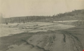
- Photograph of the flood of the Cottonwood River. Water can be seen flooding through a wooden fence on the riverbank and two men are visible walking to the right. Trees and other debris are floating down the river.
- Repository
- City of Burnaby Archives
- Date
- 1937
- Collection/Fonds
- Burnaby Historical Society fonds
- Subseries
- Peers family subseries
- Physical Description
- 1 photograph : b&w ; 12.3 x 19.7 cm on page 17.5 x 26 cm
- Description Level
- Item
- Record No.
- 020-154
- Access Restriction
- No restrictions
- Reproduction Restriction
- No known restrictions
- Accession Number
- BHS2007-04
- Scope and Content
- Photograph of the flood of the Cottonwood River. Water can be seen flooding through a wooden fence on the riverbank and two men are visible walking to the right. Trees and other debris are floating down the river.
- Media Type
- Photograph
- Notes
- Title based on caption accompanying photograph
Images

Deer Lake Brook in flood
https://search.heritageburnaby.ca/link/archivedescription39387
- Repository
- City of Burnaby Archives
- Date
- 1916
- Collection/Fonds
- Peers Family and Hill Family fonds
- Description Level
- Item
- Physical Description
- 1 photograph : b&w ; 6 x 10.4 cm on page 24.5 x 32.5 cm (pasted in album)
- Scope and Content
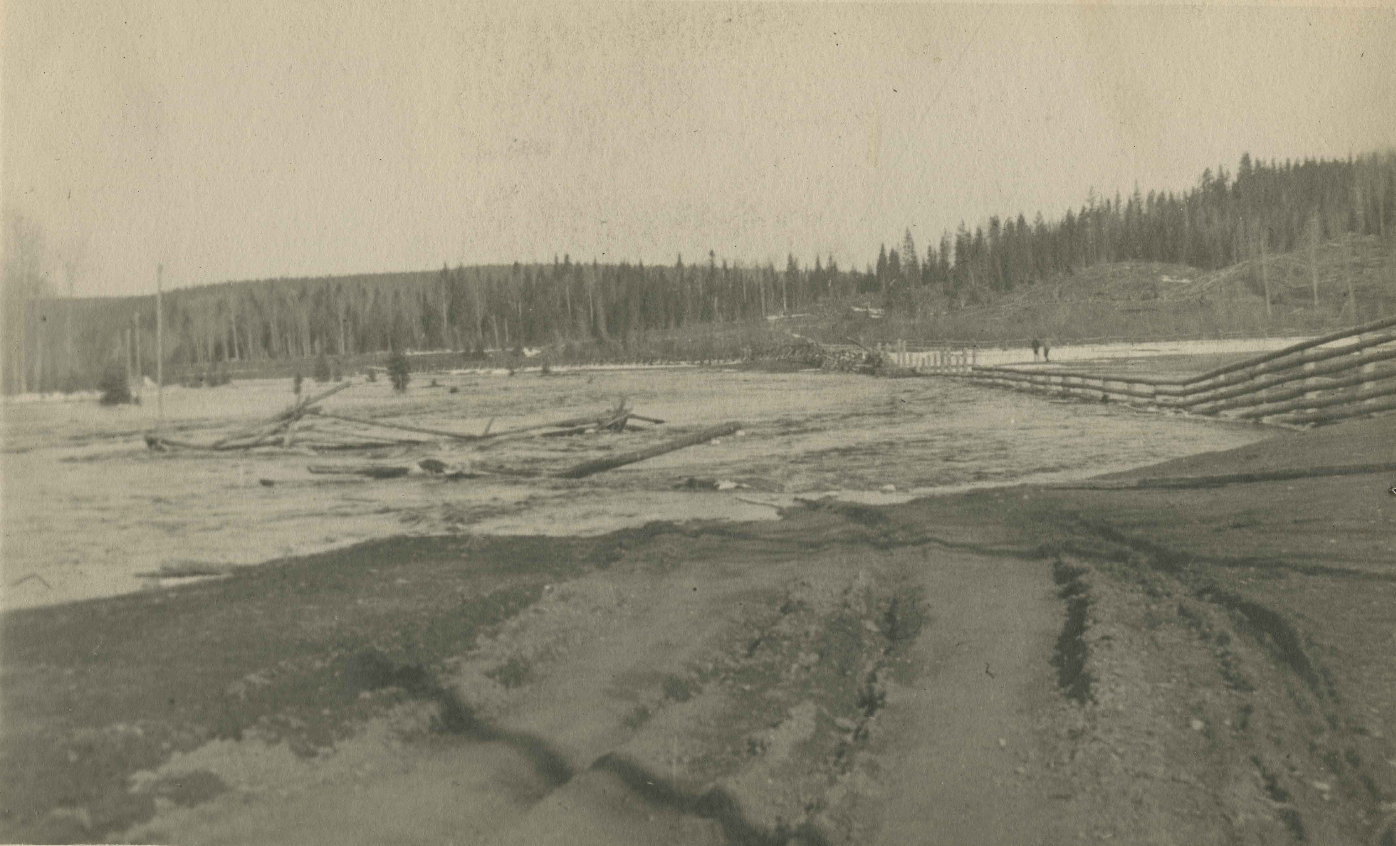
- Photograph of Deer Lake Creek; historically known as Deer Lake Brook, during a flood.
- Repository
- City of Burnaby Archives
- Date
- 1916
- Collection/Fonds
- Peers Family and Hill Family fonds
- Physical Description
- 1 photograph : b&w ; 6 x 10.4 cm on page 24.5 x 32.5 cm (pasted in album)
- Description Level
- Item
- Record No.
- 477-706
- Access Restriction
- No restrictions
- Reproduction Restriction
- No known restrictions
- Accession Number
- 2007-12
- Scope and Content
- Photograph of Deer Lake Creek; historically known as Deer Lake Brook, during a flood.
- Media Type
- Photograph
- Notes
- Title based on caption accompanying photograph
- Geographic Access
- Deer Lake Brook
- Historic Neighbourhood
- Burnaby Lake (Historic Neighbourhood)
Images


Deer Lake Brook in flood
https://search.heritageburnaby.ca/link/archivedescription39389
- Repository
- City of Burnaby Archives
- Date
- 1916
- Collection/Fonds
- Peers Family and Hill Family fonds
- Description Level
- Item
- Physical Description
- 1 photograph : b&w ; 6 x 9.8 cm on page 24.5 x 32.5 cm (pasted in album)
- Scope and Content
- Photograph of Deer Lake Creek; historically known as Deer Lake Creek, in flood.
- Repository
- City of Burnaby Archives
- Date
- 1916
- Collection/Fonds
- Peers Family and Hill Family fonds
- Physical Description
- 1 photograph : b&w ; 6 x 9.8 cm on page 24.5 x 32.5 cm (pasted in album)
- Description Level
- Item
- Record No.
- 477-708
- Access Restriction
- No restrictions
- Reproduction Restriction
- No known restrictions
- Accession Number
- 2007-12
- Scope and Content
- Photograph of Deer Lake Creek; historically known as Deer Lake Creek, in flood.
- Media Type
- Photograph
- Notes
- Title based on caption accompanying photograph
- Geographic Access
- Deer Lake Brook
- Historic Neighbourhood
- Burnaby Lake (Historic Neighbourhood)
Images

![Foggy golf course, [1999] thumbnail](/media/hpo/_Data/_Archives_Images/_Unrestricted/535/535-3115.jpg?width=280)
Foggy golf course
https://search.heritageburnaby.ca/link/archivedescription98011
- Repository
- City of Burnaby Archives
- Date
- [1999]
- Collection/Fonds
- Burnaby NewsLeader photograph collection
- Description Level
- Item
- Physical Description
- 1 photograph (tiff) : b&w
- Scope and Content
- Photograph of a person wheeling a golf caddy across a foggy golf course.
- Repository
- City of Burnaby Archives
- Date
- [1999]
- Collection/Fonds
- Burnaby NewsLeader photograph collection
- Physical Description
- 1 photograph (tiff) : b&w
- Description Level
- Item
- Record No.
- 535-3115
- Access Restriction
- No restrictions
- Reproduction Restriction
- No restrictions
- Accession Number
- 2018-12
- Scope and Content
- Photograph of a person wheeling a golf caddy across a foggy golf course.
- Media Type
- Photograph
- Notes
- Title based on contents of photograph
- Collected by editorial for use in a December 1999 issue of the Burnaby NewsLeader
Images
![Foggy golf course, [1999] thumbnail](/media/hpo/_Data/_Archives_Images/_Unrestricted/535/535-3115.jpg)
![Lougheed Drive-In Theatre storm damage, [1962] (date of original), copied 1991 thumbnail](/media/hpo/_Data/_Archives_Images/_Unrestricted/370/370-471.jpg?width=280)
Lougheed Drive-In Theatre storm damage
https://search.heritageburnaby.ca/link/archivedescription37883
- Repository
- City of Burnaby Archives
- Date
- [1962] (date of original), copied 1991
- Collection/Fonds
- Burnaby Historical Society fonds
- Description Level
- Item
- Physical Description
- 1 photograph : b&w ; 3.0 x 2.9 cm print on contact sheet 20.1 x 26.7 cm
- Scope and Content
- Photograph of damage caused by Typhoon "Freda" on October 12, 1962 to the fence at the Lougheed Drive-In Theatre on the 4200 block of Lougheed Highway at Gilmore Avenue. This photograph was taken looking down Lougheed Highway.
- Repository
- City of Burnaby Archives
- Date
- [1962] (date of original), copied 1991
- Collection/Fonds
- Burnaby Historical Society fonds
- Subseries
- Burnaby Image Bank subseries
- Physical Description
- 1 photograph : b&w ; 3.0 x 2.9 cm print on contact sheet 20.1 x 26.7 cm
- Description Level
- Item
- Record No.
- 370-471
- Access Restriction
- No restrictions
- Reproduction Restriction
- No restrictions
- Accession Number
- BHS1999-03
- Scope and Content
- Photograph of damage caused by Typhoon "Freda" on October 12, 1962 to the fence at the Lougheed Drive-In Theatre on the 4200 block of Lougheed Highway at Gilmore Avenue. This photograph was taken looking down Lougheed Highway.
- Media Type
- Photograph
- Notes
- Title based on contents of photograph
- 1 b&w copy negative accompanying
- Negative has a pink cast
- Geographic Access
- Lougheed Highway
- Historic Neighbourhood
- Broadview (Historic Neighbourhood)
- Planning Study Area
- West Central Valley Area
Images
![Lougheed Drive-In Theatre storm damage, [1962] (date of original), copied 1991 thumbnail](/media/hpo/_Data/_Archives_Images/_Unrestricted/370/370-471.jpg)

Panorama of Deer Lake Brook in flood
https://search.heritageburnaby.ca/link/archivedescription39388
- Repository
- City of Burnaby Archives
- Date
- 1916
- Collection/Fonds
- Peers Family and Hill Family fonds
- Description Level
- Item
- Physical Description
- 2 photographs : sepia panorama ; 5.5 x 10.4 cm on page 24.5 x 32.5 cm (pasted in album)
- Scope and Content
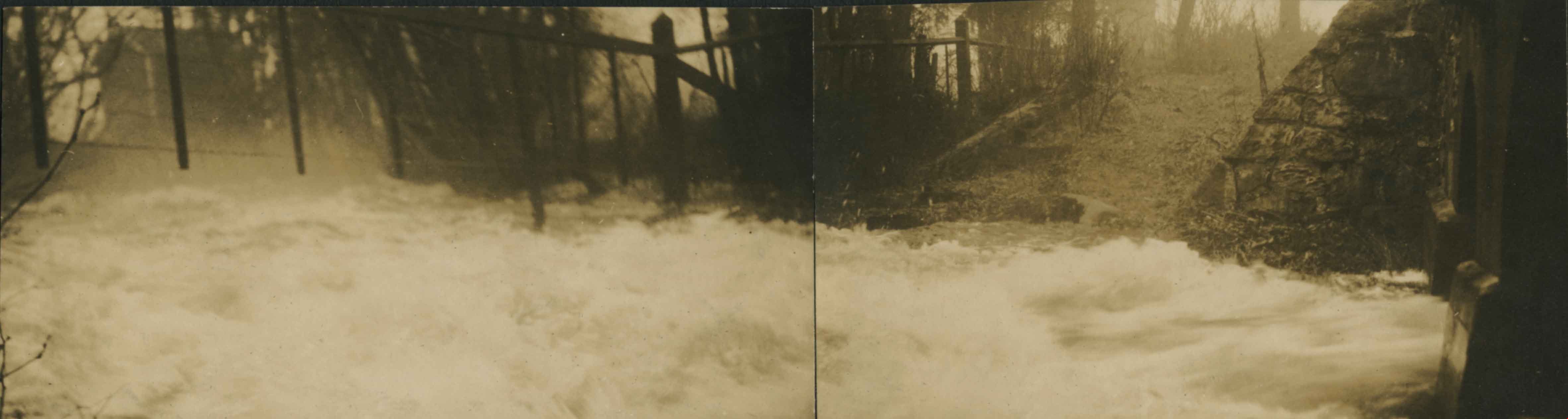
- Photographic panorama of Deer Lake Creek; historically known as Deer Lake Brook, in flood.
- Repository
- City of Burnaby Archives
- Date
- 1916
- Collection/Fonds
- Peers Family and Hill Family fonds
- Physical Description
- 2 photographs : sepia panorama ; 5.5 x 10.4 cm on page 24.5 x 32.5 cm (pasted in album)
- Description Level
- Item
- Record No.
- 477-707
- Access Restriction
- No restrictions
- Reproduction Restriction
- No known restrictions
- Accession Number
- 2007-12
- Scope and Content
- Photographic panorama of Deer Lake Creek; historically known as Deer Lake Brook, in flood.
- Media Type
- Photograph
- Notes
- Title based on caption accompanying photograph
- Geographic Access
- Deer Lake Brook
- Historic Neighbourhood
- Burnaby Lake (Historic Neighbourhood)
Images
![Photographer on foggy Burnaby Mountain, [1999] thumbnail](/media/hpo/_Data/_Archives_Images/_Unrestricted/535/535-3116.jpg?width=280)
Photographer on foggy Burnaby Mountain
https://search.heritageburnaby.ca/link/archivedescription98036
- Repository
- City of Burnaby Archives
- Date
- [1999]
- Collection/Fonds
- Burnaby NewsLeader photograph collection
- Description Level
- Item
- Physical Description
- 1 photograph (tiff) : col.
- Scope and Content
- Photograph of a photographer on Burnaby Mountain. The person is taking a photograph of the skyline, where the tops of Vancouver office towers are visible above a blanket of fog.
- Repository
- City of Burnaby Archives
- Date
- [1999]
- Collection/Fonds
- Burnaby NewsLeader photograph collection
- Physical Description
- 1 photograph (tiff) : col.
- Description Level
- Item
- Record No.
- 535-3116
- Access Restriction
- No restrictions
- Reproduction Restriction
- No restrictions
- Accession Number
- 2018-12
- Scope and Content
- Photograph of a photographer on Burnaby Mountain. The person is taking a photograph of the skyline, where the tops of Vancouver office towers are visible above a blanket of fog.
- Media Type
- Photograph
- Photographer
- Bartel, Mario
- Notes
- Title based on caption
- Collected by editorial for use in a December 1999 issue of the Burnaby NewsLeader
- Caption from metadata: "The low fog that has shrouded much of the Lower Mainland for more than a week has been a lure for photographers atop Burnaby Mountain, who are able to capture a unique view of Burnaby."
- Geographic Access
- Burnaby Mountain Conservation Area
- Planning Study Area
- Burnaby Mountain Area
Images
![Photographer on foggy Burnaby Mountain, [1999] thumbnail](/media/hpo/_Data/_Archives_Images/_Unrestricted/535/535-3116.jpg)
![Willingdon on-ramp flooding, [2005] thumbnail](/media/hpo/_Data/_Archives_Images/_Unrestricted/535/535-1860-1.jpg?width=280)
Willingdon on-ramp flooding
https://search.heritageburnaby.ca/link/archivedescription96163
- Repository
- City of Burnaby Archives
- Date
- [2005]
- Collection/Fonds
- Burnaby NewsLeader photograph collection
- Description Level
- File
- Physical Description
- 2 photographs (tiff) : col.
- Scope and Content
- File contains photographs of flooding at the Willingdon on-ramp to Highway 1 in Burnaby after a significant rainstorm. Photographs depict a worker placing pylons to close the on-ramp and cars attempting to drive through deep puddles by the highway.
- Repository
- City of Burnaby Archives
- Date
- [2005]
- Collection/Fonds
- Burnaby NewsLeader photograph collection
- Physical Description
- 2 photographs (tiff) : col.
- Description Level
- File
- Record No.
- 535-1860
- Access Restriction
- No restrictions
- Reproduction Restriction
- No restrictions
- Accession Number
- 2018-12
- Scope and Content
- File contains photographs of flooding at the Willingdon on-ramp to Highway 1 in Burnaby after a significant rainstorm. Photographs depict a worker placing pylons to close the on-ramp and cars attempting to drive through deep puddles by the highway.
- Media Type
- Photograph
- Photographer
- Bartel, Mario
- Notes
- Title based on caption
- Collected by editorial for use in a January 2005 issue of the Burnaby NewsLeader
- Caption from metadata for 535-1860-1: "A worker for Mainroad Contracting closes the Willingdon on-ramp to Highway 1 because of flooding during Monday's torrential rainstorm."
- Caption from metadata for 535-1860-2: "After two weeks of snow and cold temperatures, Lower Mainland drivers find themselves in familiar territory, plowing through deep puddles on Willingdon, just north of Highway 1."
- Geographic Access
- Willingdon Avenue
- Planning Study Area
- West Central Valley Area
Images
![Willingdon on-ramp flooding, [2005] thumbnail](/media/hpo/_Data/_Archives_Images/_Unrestricted/535/535-1860-1.jpg)
![Burnaby Mountain, [between 1958 and 1965] (date of original), copied 1991 thumbnail](/media/hpo/_Data/_Archives_Images/_Unrestricted/370/370-797.jpg?width=280)
Burnaby Mountain
https://search.heritageburnaby.ca/link/archivedescription38210
- Repository
- City of Burnaby Archives
- Date
- [between 1958 and 1965] (date of original), copied 1991
- Collection/Fonds
- Burnaby Historical Society fonds
- Description Level
- Item
- Physical Description
- 1 photograph : b&w ; 3.2 x 5.1 cm print on contact sheet 20.5 x 26.8 cm
- Scope and Content
- Aerial photograph of Centennial Park, Burnaby Mountain and Burrard Inlet looking east.
- Repository
- City of Burnaby Archives
- Date
- [between 1958 and 1965] (date of original), copied 1991
- Collection/Fonds
- Burnaby Historical Society fonds
- Subseries
- Burnaby Image Bank subseries
- Physical Description
- 1 photograph : b&w ; 3.2 x 5.1 cm print on contact sheet 20.5 x 26.8 cm
- Description Level
- Item
- Record No.
- 370-797
- Access Restriction
- No restrictions
- Reproduction Restriction
- No restrictions
- Accession Number
- BHS1999-03
- Scope and Content
- Aerial photograph of Centennial Park, Burnaby Mountain and Burrard Inlet looking east.
- Subjects
- Aerial Photographs
- Geographic Features - Inlets
- Geographic Features - Mountains
- Geographic Features - Parks
- Media Type
- Photograph
- Notes
- Title based on contents of photograph
- 1 b&w copy negative accompanying
- Geographic Access
- Burnaby Mountain Conservation Area
- Planning Study Area
- Burnaby Mountain Area
Images
![Burnaby Mountain, [between 1958 and 1965] (date of original), copied 1991 thumbnail](/media/hpo/_Data/_Archives_Images/_Unrestricted/370/370-797.jpg)