More like 'Salmon Gillnetter'
Narrow Results By
Subject
- Academic Disciplines 1
- Accidents 6
- Accidents - Automobile Accidents 11
- Accidents - Train Accidents 9
- Adornment
- Adornment - Lapel Pins 1
- Advertising Medium 16
- Advertising Medium - Signs and Signboards
- Aerial Photographs 36
- Agricultural Tools and Equipment 6
- Agricultural Tools and Equipment - Gardening Equipment 6
- Agricultural Tools and Equipment - Plows 9
Person / Organization
- Admiral Hotel 1
- Anthony, Bill 1
- BC Society of Model Engineers (BCSME) 1
- British Columbia Electric Railway Company 12
- British Columbia Hydro and Power Authority 1
- Burnaby Art Gallery 1
- Burnaby Garage 1
- Burnaby General Hospital 1
- Burnaby Players 1
- Burnaby Village Museum 1
- Canadian Pacific Railway Company 1
- Denby Brothers and Company 1
![Caila Anderson with traffic signs, [2000] thumbnail](/media/hpo/_Data/_Archives_Images/_Unrestricted/535/535-2547.jpg?width=280)
Caila Anderson with traffic signs
https://search.heritageburnaby.ca/link/archivedescription97015
- Repository
- City of Burnaby Archives
- Date
- [2000]
- Collection/Fonds
- Burnaby NewsLeader photograph collection
- Description Level
- Item
- Physical Description
- 1 photograph (tiff) : col.
- Scope and Content
- Photograph of Caila Anderson, an employee of International SPFX, standing with her arms crossed next to two traffic signs on Greenwood Street.
- Repository
- City of Burnaby Archives
- Date
- [2000]
- Collection/Fonds
- Burnaby NewsLeader photograph collection
- Physical Description
- 1 photograph (tiff) : col.
- Description Level
- Item
- Record No.
- 535-2547
- Access Restriction
- No restrictions
- Reproduction Restriction
- No restrictions
- Accession Number
- 2018-12
- Scope and Content
- Photograph of Caila Anderson, an employee of International SPFX, standing with her arms crossed next to two traffic signs on Greenwood Street.
- Subjects
- Planning - City Planning
- Advertising Medium - Signs and Signboards
- Geographic Features - Roads
- Media Type
- Photograph
- Photographer
- Bartel, Mario
- Notes
- Title based on caption
- Collected by editorial for use in a July 2000 issue of the Burnaby NewsLeader
- Caption from metadata: "Caila Anderson, of International SPFX, says new traffic regulations on Greenwood St. have made it really inconvenient for employees at the movie special effects company to get to and from their production offices. Residents on the street say the regulations haven't gone far enough."
- Geographic Access
- Greenwood Street
- Historic Neighbourhood
- Lozells (Historic Neighbourhood)
- Planning Study Area
- Government Road Area
Images
![Caila Anderson with traffic signs, [2000] thumbnail](/media/hpo/_Data/_Archives_Images/_Unrestricted/535/535-2547.jpg)

COVID-19 sign in Conderation Park
https://search.heritageburnaby.ca/link/museumdescription15363
- Repository
- Burnaby Village Museum
- Date
- 6 May 2020
- Collection/Fonds
- Burnaby Village Museum COVID-19 collection
- Description Level
- Item
- Physical Description
- 1 photograph (jpg)
- Scope and Content
- Photograph of a City of Burnaby COVID-19 sign in Confederation Park. Sign is attached to a tree near the running track and reads: "Do your part, Stay Apart..." and includes an illustration of two figures standing two metres apart. People are walking and running on the track and the tennis and baske…
- Repository
- Burnaby Village Museum
- Collection/Fonds
- Burnaby Village Museum COVID-19 collection
- Description Level
- Item
- Physical Description
- 1 photograph (jpg)
- Scope and Content
- Photograph of a City of Burnaby COVID-19 sign in Confederation Park. Sign is attached to a tree near the running track and reads: "Do your part, Stay Apart..." and includes an illustration of two figures standing two metres apart. People are walking and running on the track and the tennis and basketball courts are visible in the distance.
- Geographic Access
- Albert Street
- Confederation Park
- Accession Code
- BV021.2.25
- Access Restriction
- No restrictions
- Reproduction Restriction
- May be restricted by third party rights
- Date
- 6 May 2020
- Media Type
- Photograph
- Planning Study Area
- Sperling-Broadway Area
- Notes
- Title based on contents of photograph
Images


Do Your Part Eagle
https://search.heritageburnaby.ca/link/archivedescription95084
- Repository
- City of Burnaby Archives
- Date
- June 13, 2020
- Collection/Fonds
- Burnaby Photographic Society fonds
- Description Level
- Item
- Physical Description
- 1 photograph (tiff)
- Scope and Content
- Photograph of a sign along the Burnaby Lake Freeway Trail that reads: "Do your part. Stay 2 metres apart." The sign has a silhoutte drawing of an eagle with its wings open to illustrate the distance of two metres.
- Repository
- City of Burnaby Archives
- Date
- June 13, 2020
- Collection/Fonds
- Burnaby Photographic Society fonds
- Physical Description
- 1 photograph (tiff)
- Description Level
- Item
- Record No.
- 623-003
- Access Restriction
- No restrictions
- Reproduction Restriction
- No restrictions
- Accession Number
- 2020-10
- Scope and Content
- Photograph of a sign along the Burnaby Lake Freeway Trail that reads: "Do your part. Stay 2 metres apart." The sign has a silhoutte drawing of an eagle with its wings open to illustrate the distance of two metres.
- Media Type
- Photograph
- Photographer
- Gervan, Bonnie
- Notes
- Transcribed title
- Photographer's caption: "A sign shows how far to keep apart."
- Geographic Access
- Burnaby Lake Regional Nature Park
- Historic Neighbourhood
- Burnaby Lake (Historic Neighbourhood)
- Planning Study Area
- Burnaby Lake Area
Images

![Granville Street, Vancouver, [1910] thumbnail](/media/hpo/_Data/_BVM_Images/1972/1972_0050_0008_001.jpg?width=280)
Granville Street, Vancouver
https://search.heritageburnaby.ca/link/museumdescription1069
- Repository
- Burnaby Village Museum
- Date
- [1910]
- Collection/Fonds
- Burnaby Village Museum Photograph collection
- Description Level
- Item
- Physical Description
- 1 photograph : b&w ; 7.4 x 9.8 cm
- Scope and Content
- Photograph of Granville Street, looking north. Signs for "Fletchers Pianos" and the "Colonial Theatre" can be seen. The north shore is faintly visible across Burrard Inlet.
- Repository
- Burnaby Village Museum
- Collection/Fonds
- Burnaby Village Museum Photograph collection
- Description Level
- Item
- Physical Description
- 1 photograph : b&w ; 7.4 x 9.8 cm
- Scope and Content
- Photograph of Granville Street, looking north. Signs for "Fletchers Pianos" and the "Colonial Theatre" can be seen. The north shore is faintly visible across Burrard Inlet.
- Subjects
- Advertising Medium - Signs and Signboards
- Buildings - Commercial
- Geographic Features - Roads
- Geographic Access
- Vancouver
- Accession Code
- HV972.50.8
- Access Restriction
- No restrictions
- Reproduction Restriction
- No known restrictions
- Date
- [1910]
- Media Type
- Photograph
- Scan Resolution
- 600
- Scan Date
- 2023-04-04
- Photographer
- Dean, H.M.
- Notes
- Title based on contents of photograph
- An annotation on the back of the photograph reads, "Granville St. - 1910."
Images
![Granville Street, Vancouver, [1910] thumbnail](/media/hpo/_Data/_BVM_Images/1972/1972_0050_0008_001.jpg)

Hastings Street
https://search.heritageburnaby.ca/link/archivedescription51467
- Repository
- City of Burnaby Archives
- Date
- 1968
- Collection/Fonds
- Harold H. Johnston fonds
- Description Level
- Item
- Physical Description
- 1 photograph (jpeg) : b&w
- Scope and Content
- Photograph taken looking east along Hastings Street, near Gilmore Avenue. The photograph was taken at night and a number of businesses and business signs are visible, including those for Wosk's and the Admiral Hotel (at 4125 Hastings).
- Repository
- City of Burnaby Archives
- Date
- 1968
- Collection/Fonds
- Harold H. Johnston fonds
- Physical Description
- 1 photograph (jpeg) : b&w
- Description Level
- Item
- Record No.
- 483-068
- Access Restriction
- No restrictions
- Reproduction Restriction
- No reproduction permitted
- Accession Number
- 2008-08
- Scope and Content
- Photograph taken looking east along Hastings Street, near Gilmore Avenue. The photograph was taken at night and a number of businesses and business signs are visible, including those for Wosk's and the Admiral Hotel (at 4125 Hastings).
- Names
- Admiral Hotel
- Media Type
- Photograph
- Photographer
- Johnston, Harold H.
- Notes
- Title based on contents of photograph
- Geographic Access
- Hastings Street
- Street Address
- 4125 Hastings Street
- Historic Neighbourhood
- Vancouver Heights (Historic Neighbourhood)
- Planning Study Area
- Burnaby Heights Area
Images

![Highway Improvement Project signage, [1972] thumbnail](/media/hpo/_Data/_Archives_Images/_Unrestricted/480/480-280.jpg?width=280)
Highway Improvement Project signage
https://search.heritageburnaby.ca/link/archivedescription45385
- Repository
- City of Burnaby Archives
- Date
- [1972]
- Collection/Fonds
- Columbian Newspaper collection
- Description Level
- Item
- Physical Description
- 1 photograph : b&w ; 14 x 21 cm
- Scope and Content
- Photograph of Highway Improvement Project signage (developed by the British Columbian Government under W.A.C. Bennett) along the Trans Canada Highway.
- Repository
- City of Burnaby Archives
- Date
- [1972]
- Collection/Fonds
- Columbian Newspaper collection
- Physical Description
- 1 photograph : b&w ; 14 x 21 cm
- Description Level
- Item
- Record No.
- 480-280
- Access Restriction
- No restrictions
- Reproduction Restriction
- No restrictions
- Accession Number
- 2003-02
- Scope and Content
- Photograph of Highway Improvement Project signage (developed by the British Columbian Government under W.A.C. Bennett) along the Trans Canada Highway.
- Media Type
- Photograph
- Photographer
- King, Basil
- Notes
- Title based on contents of photograph
Images
![Highway Improvement Project signage, [1972] thumbnail](/media/hpo/_Data/_Archives_Images/_Unrestricted/480/480-280.jpg)

Kingsway
https://search.heritageburnaby.ca/link/archivedescription34510
- Repository
- City of Burnaby Archives
- Date
- 1920
- Collection/Fonds
- Burnaby Historical Society fonds
- Description Level
- Item
- Physical Description
- 1 photograph : sepia ; 12.6 x 17.7 cm
- Scope and Content
- Photograph of Kingsway looking east at Boundary Road. A sign on the right reads, "Burnaby / Vehicles must slow down at all schools and intersections marked thus: X." A sign on a building at the left reads, "Arctic Ice Cream." Central Park is on the right.
- Repository
- City of Burnaby Archives
- Date
- 1920
- Collection/Fonds
- Burnaby Historical Society fonds
- Subseries
- Photographs subseries
- Physical Description
- 1 photograph : sepia ; 12.6 x 17.7 cm
- Description Level
- Item
- Record No.
- 031-001
- Access Restriction
- No restrictions
- Reproduction Restriction
- No known restrictions
- Accession Number
- BHS2007-04
- Scope and Content
- Photograph of Kingsway looking east at Boundary Road. A sign on the right reads, "Burnaby / Vehicles must slow down at all schools and intersections marked thus: X." A sign on a building at the left reads, "Arctic Ice Cream." Central Park is on the right.
- Media Type
- Photograph
- Notes
- Title based on contents of photograph
- Geographic Access
- Kingsway
- Central Park
- Boundary Road
- Historic Neighbourhood
- Central Park (Historic Neighbourhood)
- Planning Study Area
- Garden Village Area
- Maywood Area
Images


Physical distancing sign
https://search.heritageburnaby.ca/link/archivedescription95106
- Repository
- City of Burnaby Archives
- Date
- 2020
- Collection/Fonds
- Burnaby Photographic Society fonds
- Description Level
- Item
- Physical Description
- 1 photograph (tiff)
- Scope and Content
- Photograph of the gardens outside the Shadbolt Centre of the Arts. In the foreground, attached to a tree is a sign encouraging social distancing; in the background is a jungle gym fenced off with orange mesh and caution tape to prohibit climbing.
- Repository
- City of Burnaby Archives
- Date
- 2020
- Collection/Fonds
- Burnaby Photographic Society fonds
- Physical Description
- 1 photograph (tiff)
- Description Level
- Item
- Record No.
- 623-024
- Access Restriction
- No restrictions
- Reproduction Restriction
- No restrictions
- Accession Number
- 2020-10
- Scope and Content
- Photograph of the gardens outside the Shadbolt Centre of the Arts. In the foreground, attached to a tree is a sign encouraging social distancing; in the background is a jungle gym fenced off with orange mesh and caution tape to prohibit climbing.
- Media Type
- Photograph
- Photographer
- King, Gloria
- Notes
- Transcribed title
- Geographic Access
- Deer Lake
- Street Address
- 6450 Deer Lake Avenue
- Historic Neighbourhood
- Burnaby Lake (Historic Neighbourhood)
- Planning Study Area
- Douglas-Gilpin Area
Images


Reconstructed Central Park Band Stand
https://search.heritageburnaby.ca/link/archivedescription95123
- Repository
- City of Burnaby Archives
- Date
- May 28, 2020
- Collection/Fonds
- Burnaby Photographic Society fonds
- Description Level
- Item
- Physical Description
- 1 photograph (tiff)
- Scope and Content
- Photograph of the band stand in Central Park. The band stand stairs are blocked off with orange netting and a City of Burnaby facility closure sign.
- Repository
- City of Burnaby Archives
- Date
- May 28, 2020
- Collection/Fonds
- Burnaby Photographic Society fonds
- Physical Description
- 1 photograph (tiff)
- Description Level
- Item
- Record No.
- 623-041
- Access Restriction
- No restrictions
- Reproduction Restriction
- No restrictions
- Accession Number
- 2020-10
- Scope and Content
- Photograph of the band stand in Central Park. The band stand stairs are blocked off with orange netting and a City of Burnaby facility closure sign.
- Subjects
- Buildings - Recreational - Bandstands
- Geographic Features - Parks
- Advertising Medium - Signs and Signboards
- Media Type
- Photograph
- Photographer
- Cheung, Ray
- Notes
- Transcribed title
- Geographic Access
- Central Park
- Imperial Street
- Street Address
- 3883 Imperial Street
- Historic Neighbourhood
- Central Park (Historic Neighbourhood)
- Planning Study Area
- Maywood Area
Images

![Robert Nasato at Marine/10th Ave. Connector, [2000] thumbnail](/media/hpo/_Data/_Archives_Images/_Unrestricted/535/535-3069.jpg?width=280)
Robert Nasato at Marine/10th Ave. Connector
https://search.heritageburnaby.ca/link/archivedescription97943
- Repository
- City of Burnaby Archives
- Date
- [2000]
- Collection/Fonds
- Burnaby NewsLeader photograph collection
- Description Level
- Item
- Physical Description
- 1 photograph (tiff) : col.
- Scope and Content
- Photograph of Robert Nasato, the president of the West End Residents' Association, posing net to sign advertising the plans for the Marine/10th Ave. Connector.
- Repository
- City of Burnaby Archives
- Date
- [2000]
- Collection/Fonds
- Burnaby NewsLeader photograph collection
- Physical Description
- 1 photograph (tiff) : col.
- Description Level
- Item
- Record No.
- 535-3069
- Access Restriction
- No restrictions
- Reproduction Restriction
- No restrictions
- Accession Number
- 2018-12
- Scope and Content
- Photograph of Robert Nasato, the president of the West End Residents' Association, posing net to sign advertising the plans for the Marine/10th Ave. Connector.
- Media Type
- Photograph
- Photographer
- Bartel, Mario
- Notes
- Title based on caption
- Collected by editorial for use in a January 2000 issue of the Burnaby NewsLeader
- Caption from metadata: "Robert Nasato, the president of the West End Residents' Association, isn't happy about the proposed Marine/10th Ave. connector, to be built through his neighborhood."
- Geographic Access
- 10th Avenue
- Marine Drive
- Historic Neighbourhood
- Fraser Arm (Historic Neighbourhood)
- Planning Study Area
- Stride Hill Area
Images
![Robert Nasato at Marine/10th Ave. Connector, [2000] thumbnail](/media/hpo/_Data/_Archives_Images/_Unrestricted/535/535-3069.jpg)

Signage for Burnaby's COVID-19 drive thru testing site
https://search.heritageburnaby.ca/link/museumdescription15370
- Repository
- Burnaby Village Museum
- Date
- 5 Apr. 2020
- Collection/Fonds
- Burnaby Village Museum COVID-19 collection
- Description Level
- Item
- Physical Description
- 1 photograph (jpg)
- Scope and Content
- Photograph of portable LED signage at entrance to COVID-19 drive thru test site in Central Park parking lot in Burnaby. LED sign reads "Covid Care Enter Here".
- Repository
- Burnaby Village Museum
- Collection/Fonds
- Burnaby Village Museum COVID-19 collection
- Description Level
- Item
- Physical Description
- 1 photograph (jpg)
- Scope and Content
- Photograph of portable LED signage at entrance to COVID-19 drive thru test site in Central Park parking lot in Burnaby. LED sign reads "Covid Care Enter Here".
- Subjects
- Advertising Medium - Signs and Signboards
- Geographic Features - Parks
- Public Services - Health Services
- Pandemics - COVID-19
- Geographic Access
- Central Park
- Imperial Street
- Accession Code
- BV021.2.35
- Access Restriction
- No restrictions
- Reproduction Restriction
- May be restricted by third party rights
- Date
- 5 Apr. 2020
- Media Type
- Photograph
- Historic Neighbourhood
- Central Park (Historic Neighbourhood)
- Planning Study Area
- Maywood Area
- Notes
- Title based on contents of photograph
Images


Signage for Burnaby's COVID-19 drive thru testing site
https://search.heritageburnaby.ca/link/museumdescription15371
- Repository
- Burnaby Village Museum
- Date
- 5 Apr. 2020
- Collection/Fonds
- Burnaby Village Museum COVID-19 collection
- Description Level
- Item
- Physical Description
- 1 photograph (jpg)
- Scope and Content
- Photograph of portable LED signage at entrance to COVID-19 drive thru testing site in Central Park parking lot in Burnaby. LED sign reads "Mon-Fri / 12-5:45".
- Repository
- Burnaby Village Museum
- Collection/Fonds
- Burnaby Village Museum COVID-19 collection
- Description Level
- Item
- Physical Description
- 1 photograph (jpg)
- Scope and Content
- Photograph of portable LED signage at entrance to COVID-19 drive thru testing site in Central Park parking lot in Burnaby. LED sign reads "Mon-Fri / 12-5:45".
- Subjects
- Advertising Medium - Signs and Signboards
- Geographic Features - Parks
- Public Services - Health Services
- Pandemics - COVID-19
- Geographic Access
- Central Park
- Imperial Street
- Accession Code
- BV021.2.36
- Access Restriction
- No restrictions
- Reproduction Restriction
- May be restricted by third party rights
- Date
- 5 Apr. 2020
- Media Type
- Photograph
- Historic Neighbourhood
- Central Park (Historic Neighbourhood)
- Planning Study Area
- Maywood Area
- Notes
- Title based on contents of photograph
Images


Signage for Burnaby's COVID-19 drive thru testing site
https://search.heritageburnaby.ca/link/museumdescription15372
- Repository
- Burnaby Village Museum
- Date
- 5 Apr. 2020
- Collection/Fonds
- Burnaby Village Museum COVID-19 collection
- Description Level
- Item
- Physical Description
- 1 photograph (jpg)
- Scope and Content
- Photograph of portable LED signage at entrance to COVID-19 drive thru testing site in Central Park parking lot in Burnaby. LED sign reads "Burnaby Corona Virus.Com"
- Repository
- Burnaby Village Museum
- Collection/Fonds
- Burnaby Village Museum COVID-19 collection
- Description Level
- Item
- Physical Description
- 1 photograph (jpg)
- Scope and Content
- Photograph of portable LED signage at entrance to COVID-19 drive thru testing site in Central Park parking lot in Burnaby. LED sign reads "Burnaby Corona Virus.Com"
- Subjects
- Advertising Medium - Signs and Signboards
- Geographic Features - Parks
- Public Services - Health Services
- Pandemics - COVID-19
- Geographic Access
- Central Park
- Imperial Street
- Accession Code
- BV021.2.37
- Access Restriction
- No restrictions
- Reproduction Restriction
- May be restricted by third party rights
- Date
- 5 Apr. 2020
- Media Type
- Photograph
- Historic Neighbourhood
- Central Park (Historic Neighbourhood)
- Planning Study Area
- Maywood Area
- Notes
- Title based on contents of photograph
Images


Signage for Burnaby's COVID-19 drive thru testing site
https://search.heritageburnaby.ca/link/museumdescription15373
- Repository
- Burnaby Village Museum
- Date
- 5 Apr. 2020
- Collection/Fonds
- Burnaby Village Museum COVID-19 collection
- Description Level
- Item
- Physical Description
- 1 photograph (jpg)
- Scope and Content
- Photograph of portable LED signage at entrance to COVID-19 drive thru testing site in Central Park parking lot in Burnaby. LED sign reads "Sat-Sun / 12:30-5:15".
- Repository
- Burnaby Village Museum
- Collection/Fonds
- Burnaby Village Museum COVID-19 collection
- Description Level
- Item
- Physical Description
- 1 photograph (jpg)
- Scope and Content
- Photograph of portable LED signage at entrance to COVID-19 drive thru testing site in Central Park parking lot in Burnaby. LED sign reads "Sat-Sun / 12:30-5:15".
- Subjects
- Advertising Medium - Signs and Signboards
- Geographic Features - Parks
- Public Services - Health Services
- Pandemics - COVID-19
- Geographic Access
- Central Park
- Imperial Street
- Accession Code
- BV021.2.38
- Access Restriction
- No restrictions
- Reproduction Restriction
- May be restricted by third party rights
- Date
- 5 Apr. 2020
- Media Type
- Photograph
- Historic Neighbourhood
- Central Park (Historic Neighbourhood)
- Planning Study Area
- Maywood Area
- Notes
- Title based on contents of photograph
Images


Social distance in Burnaby Parks
https://search.heritageburnaby.ca/link/archivedescription95093
- Repository
- City of Burnaby Archives
- Date
- May 8, 2020
- Collection/Fonds
- Burnaby Photographic Society fonds
- Description Level
- Item
- Physical Description
- 1 photograph (tiff)
- Scope and Content
- Photograph of a City of Burnaby sign encouraging social distancing attached to a tree in Mary Avenue Park.
- Repository
- City of Burnaby Archives
- Date
- May 8, 2020
- Collection/Fonds
- Burnaby Photographic Society fonds
- Physical Description
- 1 photograph (tiff)
- Description Level
- Item
- Record No.
- 623-012
- Access Restriction
- No restrictions
- Reproduction Restriction
- Reproduce for fair dealing purposes only
- Accession Number
- 2020-10
- Scope and Content
- Photograph of a City of Burnaby sign encouraging social distancing attached to a tree in Mary Avenue Park.
- Media Type
- Photograph
- Photographer
- Asbia, Cher
- Notes
- Transcribed title
- Geographic Access
- 12th Avenue
- Historic Neighbourhood
- Edmonds (Historic Neighbourhood)
- Planning Study Area
- Edmonds Area
Images


Swangard Stadium closed
https://search.heritageburnaby.ca/link/archivedescription95096
- Repository
- City of Burnaby Archives
- Date
- April 21, 2020
- Collection/Fonds
- Burnaby Photographic Society fonds
- Description Level
- Item
- Physical Description
- 1 photograph (tiff)
- Scope and Content
- Photograph of two City of Burnaby signs attached to fencing outside Swangard Stadium in Central Park. The signs announce the facility's closure in response to the COVID-19 pandemic. Behind the fencing, the stadium's track and bleachers are visible.
- Repository
- City of Burnaby Archives
- Date
- April 21, 2020
- Collection/Fonds
- Burnaby Photographic Society fonds
- Physical Description
- 1 photograph (tiff)
- Description Level
- Item
- Record No.
- 623-015
- Access Restriction
- No restrictions
- Reproduction Restriction
- No restrictions
- Accession Number
- 2020-10
- Scope and Content
- Photograph of two City of Burnaby signs attached to fencing outside Swangard Stadium in Central Park. The signs announce the facility's closure in response to the COVID-19 pandemic. Behind the fencing, the stadium's track and bleachers are visible.
- Names
- Swangard Stadium
- Media Type
- Photograph
- Photographer
- Damer, Eric
- Notes
- Transcribed title
- Geographic Access
- Central Park
- Imperial Street
- Street Address
- 3883 Imperial Street
- Historic Neighbourhood
- Central Park (Historic Neighbourhood)
- Planning Study Area
- Maywood Area
Images


Temporary one way at Deer Lake Park
https://search.heritageburnaby.ca/link/archivedescription95111
- Repository
- City of Burnaby Archives
- Date
- April 10, 2020
- Collection/Fonds
- Burnaby Photographic Society fonds
- Description Level
- Item
- Physical Description
- 1 photograph (tiff)
- Scope and Content
- Photograph of a sign detailing a temporary one-way walking route for Deer Lake Park. The sign is posted at the Royal Oak entrance of the park.
- Repository
- City of Burnaby Archives
- Date
- April 10, 2020
- Collection/Fonds
- Burnaby Photographic Society fonds
- Physical Description
- 1 photograph (tiff)
- Description Level
- Item
- Record No.
- 623-029
- Access Restriction
- No restrictions
- Reproduction Restriction
- No restrictions
- Accession Number
- 2020-10
- Scope and Content
- Photograph of a sign detailing a temporary one-way walking route for Deer Lake Park. The sign is posted at the Royal Oak entrance of the park.
- Media Type
- Photograph
- Photographer
- Snowdon, Nick
- Notes
- Transcribed title
- Photographer's caption: "Big signs show the one way system at Deer Lake. The signs are not detailed and lead to some confusion. Other signs are spread throughout the park including spay paint on the trails."
- Geographic Access
- Deer Lake Park
- Planning Study Area
- Windsor Area
Images

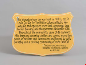
plaque
https://search.heritageburnaby.ca/link/museumartifact36450
- Repository
- Burnaby Village Museum
- Accession Code
- BV994.38.1
- Description
- Plaque. Badge shaped, made of ply-wooden, the background is painted yellow/tan and the lettering is black.
- Object History
- The plaque commemorates the history of the British Columbia Electric Railway in Burnaby, and the preservation of tram #1223 by the Burnaby Historical Society in 1958. Interurban tram No. 1223 has been restored by the joint efforts of the Friends of 1223 and Burnaby Village Museum. In March 2007 the tram was officially returned to Burnaby Village Museum and is currently on display, in a replica of a Tram Car Barn, at the Museum.
- Fraser Wilson hand lettered the sign.
- Marks/Labels
- "This Interurban Tram Car was built in 1913 by the St. Louis Car Co. for the British Columbia Electric Railway Co. and operated over that company's three lines in Burnaby until abandonment, November 1956. Throughout the nearly fifty years of its existence this tram and seventy similar cars carried many thousands of settlers and commuters and helped to build Burnaby into a thriving community of over 80,000"; "Dedicated and placed here by Burnaby Historical Society. Nov. 30th 1958", hand lettered.
- Subjects
- Transportation
- Transportation - Public Transit
- Transportation - Electric Railroads
- Advertising Medium
- Advertising Medium - Signs and Signboards
Images
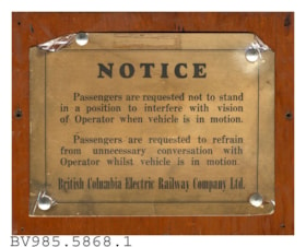
plaque
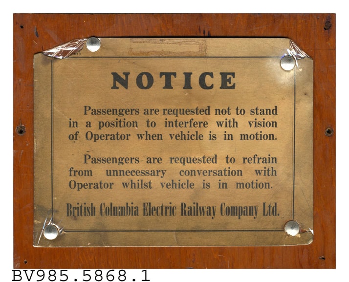
https://search.heritageburnaby.ca/link/museumartifact40427
- Repository
- Burnaby Village Museum
- Accession Code
- BV985.5868.1
- Description
- Notice - Plaque. Wood backed plaque with cardboard notice from the British Columbia Electric Railway Company advising passengers to stand in a position that does not interfere with the Operator's vision while the vehicle was in motion. The notice also requests that the passengers refrain from unnecessary conversation with the Operator while the vehicle is in motion. The notice is attached to the wood with four tacks. The wood backing is 23.5cm x 18.5cm and the cardboard is 20cm x 15cm.
- Subjects
- Advertising Medium
- Advertising Medium - Signs and Signboards
- Transportation
- Transportation - Electric Railroads
- Transportation - Public Transit
Images
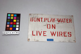
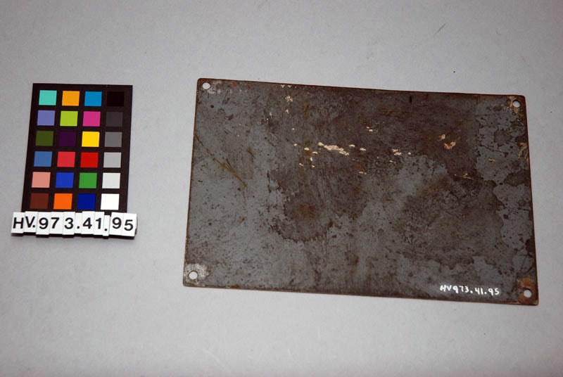
Sign
https://search.heritageburnaby.ca/link/museumartifact29019
- Repository
- Burnaby Village Museum
- Accession Code
- HV973.41.95
- Description
- Rectangular metallic, magnetic silver painted with "DONT PLAY WATER ON LIVE WIRES" painted in red. A blue sticker with "KS-K5" glued on the bottom. Four mounting holes in the corners. Length: 19.3 cm Width: 12.7 cm Thickness: 1 mm
- Object History
- key system S.F. California.
- Marks/Labels
- "DONT PLAY WATER" "ON" "LIVE WIRES"; Blue sticker "KS-KS";
- Subjects
- Transportation
- Transportation - Public Transit
- Transportation - Electric Railroads
- Advertising Medium
- Advertising Medium - Signs and Signboards
Images