More like 'Opening of Confederation park playground'
Narrow Results By
Subject
- Accidents - Automobile Accidents 2
- Advertising Medium 6
- Advertising Medium - Signs and Signboards 97
- Aerial Photographs 44
- Agricultural Tools and Equipment 2
- Agricultural Tools and Equipment - Gardening Equipment 4
- Agricultural Tools and Equipment - Plows 5
- Agriculture 4
- Agriculture - Crops 2
- Agriculture - Farms 59
- Agriculture - Fruit and Berries 6
- Agriculture - Poultry 4

Confederation Park playground
https://search.heritageburnaby.ca/link/archivedescription38667
- Repository
- City of Burnaby Archives
- Date
- 1927
- Collection/Fonds
- Burnaby Historical Society fonds
- Description Level
- Item
- Physical Description
- 1 photograph : b&w ; 19 x 23.5 cm
- Scope and Content
- Photograph of the opening of the Confederation Park playground. A group of children and adults can be seen gathered around and using the swings and slides and other playground equipment. A number of homes on Capitol Hill can be seen in the backgound. Confederation Park opened on June 25, 1927.
- Repository
- City of Burnaby Archives
- Date
- 1927
- Collection/Fonds
- Burnaby Historical Society fonds
- Subseries
- North Burnaby Board of Trade subseries
- Physical Description
- 1 photograph : b&w ; 19 x 23.5 cm
- Description Level
- Item
- Record No.
- 476-010
- Access Restriction
- No restrictions
- Reproduction Restriction
- No known restrictions
- Accession Number
- BHS2005-8
- Scope and Content
- Photograph of the opening of the Confederation Park playground. A group of children and adults can be seen gathered around and using the swings and slides and other playground equipment. A number of homes on Capitol Hill can be seen in the backgound. Confederation Park opened on June 25, 1927.
- Subjects
- Geographic Features - Parks
- Recreational Devices - Playgrounds
- Persons - Crowds
- Events - Openings
- Media Type
- Photograph
- Notes
- Title based on contents of photograph
- Geographic Access
- Confederation Park
- Willingdon Avenue
- Street Address
- 250 Willingdon Avenue
- Historic Neighbourhood
- Capitol Hill (Historic Neighbourhood)
- Planning Study Area
- Capitol Hill Area
Images

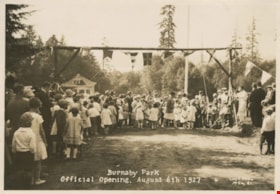
Opening of Burnaby Park
https://search.heritageburnaby.ca/link/archivedescription34257
- Repository
- City of Burnaby Archives
- Date
- August 6, 1927
- Collection/Fonds
- Burnaby Historical Society fonds
- Description Level
- Item
- Physical Description
- 1 photograph : b&w ; 11.7 x 16.7 cm
- Scope and Content
- Photograph of the opening of Burnaby Park at the foot of 2nd Street. The photograph was likely taken just after the ribbon cutting.
- Repository
- City of Burnaby Archives
- Date
- August 6, 1927
- Collection/Fonds
- Burnaby Historical Society fonds
- Subseries
- George Jeffery subseries
- Physical Description
- 1 photograph : b&w ; 11.7 x 16.7 cm
- Description Level
- Item
- Record No.
- 013-001
- Access Restriction
- No restrictions
- Reproduction Restriction
- No known restrictions
- Accession Number
- BHS2007-04
- Scope and Content
- Photograph of the opening of Burnaby Park at the foot of 2nd Street. The photograph was likely taken just after the ribbon cutting.
- Media Type
- Photograph
- Photographer
- Lloyd's Studio
- Notes
- Title based on caption of photograph
- Annotation at bottom of photograph reads, "Burnaby Park / Official Opening, August 6th 1927"
- Geographic Access
- Wedgewood Street
- Robert Burnaby Park
- Street Address
- 8155 Wedgewood Street
- Historic Neighbourhood
- Burnaby Lake (Historic Neighbourhood)
- Planning Study Area
- Lakeview-Mayfield Area
Images

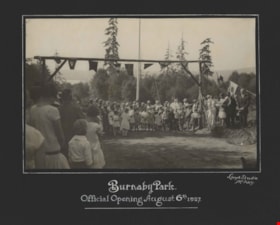
Opening of Burnaby Park
https://search.heritageburnaby.ca/link/archivedescription34576
- Repository
- City of Burnaby Archives
- Date
- August 6, 1927
- Collection/Fonds
- Burnaby Historical Society fonds
- Description Level
- Item
- Physical Description
- 1 photograph : b&w ; 15.8 x 24.2 cm mounted on 29.1 x 38.7 cm cardboard
- Scope and Content
- Photograph of the official opening of Burnaby Park at the foot of 2nd Street. A crowd is gathered under an arch decorated with flags, and a ribbon is stretched across the arch.
- Repository
- City of Burnaby Archives
- Date
- August 6, 1927
- Collection/Fonds
- Burnaby Historical Society fonds
- Subseries
- Photographs subseries
- Physical Description
- 1 photograph : b&w ; 15.8 x 24.2 cm mounted on 29.1 x 38.7 cm cardboard
- Description Level
- Item
- Record No.
- 055-001
- Access Restriction
- No restrictions
- Reproduction Restriction
- No known restrictions
- Accession Number
- BHS2007-04
- Scope and Content
- Photograph of the official opening of Burnaby Park at the foot of 2nd Street. A crowd is gathered under an arch decorated with flags, and a ribbon is stretched across the arch.
- Media Type
- Photograph
- Photographer
- Lloyd's Studio
- Notes
- Title based on contents of photograph
- Annotation on bottom front of cardboard reads, "Burnaby Park / Official Opening, August 6th, 1927"
- Geographic Access
- Robert Burnaby Park
- Wedgewood Street
- Street Address
- 8155 Wedgewood Street
- Historic Neighbourhood
- Burnaby Lake (Historic Neighbourhood)
- Planning Study Area
- Lakeview-Mayfield Area
Images


Burnaby Mountain Parking Lot & Restaurant
https://search.heritageburnaby.ca/link/archivedescription93706
- Repository
- City of Burnaby Archives
- Date
- February 15, 1978
- Collection/Fonds
- Burnaby Public Library Contemporary Visual Archive Project
- Description Level
- Item
- Physical Description
- 1 photograph : b&w ; 12.5 x 17.5 cm
- Scope and Content
- Photograph of the view of the mountains and park from a hill on Burnaby Mountain Park. The photograph is taken facing north. The photograph shows the parking lot and the Burnaby Mountain Centennial Pavilion.
- Repository
- City of Burnaby Archives
- Date
- February 15, 1978
- Collection/Fonds
- Burnaby Public Library Contemporary Visual Archive Project
- Physical Description
- 1 photograph : b&w ; 12.5 x 17.5 cm
- Description Level
- Item
- Record No.
- 556-663
- Access Restriction
- No restrictions
- Reproduction Restriction
- Reproduce for fair dealing purposes only
- Accession Number
- 2017-57
- Scope and Content
- Photograph of the view of the mountains and park from a hill on Burnaby Mountain Park. The photograph is taken facing north. The photograph shows the parking lot and the Burnaby Mountain Centennial Pavilion.
- Subjects
- Buildings - Commercial - Restaurants
- Buildings - Civic
- Buildings - Recreational
- Geographic Features - Automobile Parking Lots
- Geographic Features - Parks
- Names
- Burnaby Mountain Park
- Media Type
- Photograph
- Photographer
- Surridge, Jack
- Notes
- Title taken from project information form
- Accompanied by a project information form and 1 photograph (b&w negative ; 9.5 x 12.5 cm)
- BPL no. 111
- Geographic Access
- Burnaby Lake Regional Nature Park
- Burnaby Mountain Conservation Area
- Street Address
- 100 Centennial Way
- Planning Study Area
- Burnaby Mountain Area
Images

![Discovery Guide '99, [1999] thumbnail](/media/hpo/_Data/_Archives_Images/_Unrestricted/535/535-3119-17.jpg?width=280)
Discovery Guide '99
https://search.heritageburnaby.ca/link/archivedescription98039
- Repository
- City of Burnaby Archives
- Date
- [1999]
- Collection/Fonds
- Burnaby NewsLeader photograph collection
- Description Level
- File
- Physical Description
- 21 photographs (tiff) : col.
- Scope and Content
- File contains photographs selected for the Burnaby NewsLeader's "Discovery Guide '99." Photographs depict: mostly unidentified people taking part in recreational activities like archery, boating, golf, fishing, hiking, and pottery at locations around Burnaby; musical and dance performances; a windo…
- Repository
- City of Burnaby Archives
- Date
- [1999]
- Collection/Fonds
- Burnaby NewsLeader photograph collection
- Physical Description
- 21 photographs (tiff) : col.
- Description Level
- File
- Record No.
- 535-3119
- Access Restriction
- No restrictions
- Reproduction Restriction
- No restrictions
- Accession Number
- 2018-12
- Scope and Content
- File contains photographs selected for the Burnaby NewsLeader's "Discovery Guide '99." Photographs depict: mostly unidentified people taking part in recreational activities like archery, boating, golf, fishing, hiking, and pottery at locations around Burnaby; musical and dance performances; a window washer on a tower; and a duck swimming on a pond.
- Subjects
- Geographic Features - Lakes and Ponds
- Geographic Features - Parks
- Recreational Activities - Golf
- Recreational Activities - Boating
- Arts
- Recreational Activities
- Sports
- Performances
- Media Type
- Photograph
- Photographer
- Bartel, Mario
- Notes
- Title based on original file name
- Collected by editorial for use an issue of the Burnaby NewsLeader
- Caption from metadata for 535-3319-8: "Kurtis Tylor, of the BC Society of Model Engineers, gives Kyle Miller, 9, a close-up look at an M420 diesel engine. Kyle was part of a group of 200 kids visiting the miniature railway at Confederation Park as part of a summer program at Hastings Park."
- Caption from metadata for 535-3319-14: "Tom Stevens, of Everett, Washington, makes sure everything is shipshape on his 1:16 scale model of a 40 ft. Alaskan trawler. He started building the model in 1962, with his dad, and he was putting it through its paces at the Burnaby Association of Marine Modellers annual regatta at the pond in Central Park."
- Geographic Access
- Central Park
- Confederation Park
- Burnaby Mountain Conservation Area
Images
![Discovery Guide '99, [1999] thumbnail](/media/hpo/_Data/_Archives_Images/_Unrestricted/535/535-3119-17.jpg)

Swimming Pool Robert Burnaby Park
https://search.heritageburnaby.ca/link/archivedescription93641
- Repository
- City of Burnaby Archives
- Date
- November 19, 1977
- Collection/Fonds
- Burnaby Public Library Contemporary Visual Archive Project
- Description Level
- Item
- Physical Description
- 1 photograph : b&w ; 12.5 x 17.5 cm
- Scope and Content
- Photograph of the swimming pool and adjacent pool building in Robert Burnaby Park. The photograph is taken facing north, from a nearby high point.
- Repository
- City of Burnaby Archives
- Date
- November 19, 1977
- Collection/Fonds
- Burnaby Public Library Contemporary Visual Archive Project
- Physical Description
- 1 photograph : b&w ; 12.5 x 17.5 cm
- Description Level
- Item
- Record No.
- 556-598
- Access Restriction
- No restrictions
- Reproduction Restriction
- Reproduce for fair dealing purposes only
- Accession Number
- 2017-57
- Scope and Content
- Photograph of the swimming pool and adjacent pool building in Robert Burnaby Park. The photograph is taken facing north, from a nearby high point.
- Subjects
- Geographic Features - Parks
- Buildings - Recreational - Outdoor Swimming Pools
- Buildings - Recreational - Swimming Pools
- Media Type
- Photograph
- Photographer
- Surridge, Jack
- Notes
- Title taken from project information form
- Accompanied by a project information form and 1 photograph (b&w negative ; 9.5 x 12.5 cm)
- BPL no. 48
- Geographic Access
- Robert Burnaby Park
- Street Address
- 8175 Wedgewood Street
- Historic Neighbourhood
- East Burnaby (Historic Neighbourhood)
- Planning Study Area
- Lakeview-Mayfield Area
Images

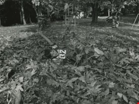
Boy playing in leaves at the park
https://search.heritageburnaby.ca/link/archivedescription59147
- Repository
- City of Burnaby Archives
- Date
- ca.1983
- Collection/Fonds
- Columbian Newspaper collection
- Description Level
- Item
- Physical Description
- 1 photograph : b&w ; 20.5 x 25.5 cm
- Scope and Content
- Photograph of an unidentified boy playing in a pile of leaves by a playground.
- Repository
- City of Burnaby Archives
- Date
- ca.1983
- Collection/Fonds
- Columbian Newspaper collection
- Physical Description
- 1 photograph : b&w ; 20.5 x 25.5 cm
- Description Level
- Item
- Record No.
- 480-1482
- Access Restriction
- No restrictions
- Reproduction Restriction
- Reproduce for fair dealing purposes only
- Accession Number
- 2009-01
- Scope and Content
- Photograph of an unidentified boy playing in a pile of leaves by a playground.
- Media Type
- Photograph
- Photographer
- Braid, Tom
- Notes
- Title based on contents of photograph
- Note on recto reads: "A-1 100%" and is crossed out
- Photographer's stamp on verso
- Note on verso reads: "page A-1 / Burnaby / Today / PMT 100%"
Images


Burnaby Lake Sign (Nature House)
https://search.heritageburnaby.ca/link/archivedescription93629
- Repository
- City of Burnaby Archives
- Date
- October 22, 1977
- Collection/Fonds
- Burnaby Public Library Contemporary Visual Archive Project
- Description Level
- Item
- Physical Description
- 1 photograph : b&w ; 12.5 x 17.5 cm
- Scope and Content
- Photograph of the sign welcoming the public to the Nature House and Burnaby Lake. The sign depicts a map of Burnaby Lake and points of interest, including the rowing complex, pool, ice rink, and Old Mill Site. A smaller sign shows the address of 4519 Piper and a small footbridge is in the backgroun…
- Repository
- City of Burnaby Archives
- Date
- October 22, 1977
- Collection/Fonds
- Burnaby Public Library Contemporary Visual Archive Project
- Physical Description
- 1 photograph : b&w ; 12.5 x 17.5 cm
- Description Level
- Item
- Record No.
- 556-586
- Access Restriction
- No restrictions
- Reproduction Restriction
- Reproduce for fair dealing purposes only
- Accession Number
- 2017-57
- Scope and Content
- Photograph of the sign welcoming the public to the Nature House and Burnaby Lake. The sign depicts a map of Burnaby Lake and points of interest, including the rowing complex, pool, ice rink, and Old Mill Site. A smaller sign shows the address of 4519 Piper and a small footbridge is in the background. The photograph is taken facing southwest.
- Media Type
- Photograph
- Photographer
- Surridge, Jack
- Notes
- Title taken from project information form
- Accompanied by a project information form and 1 photograph (b&w negative ; 9.5 x 12.5 cm)
- BPL no. 35
- Geographic Access
- Burnaby Lake Regional Nature Park
- Street Address
- 4519 Piper Avenue
- Historic Neighbourhood
- Lozells (Historic Neighbourhood)
- Planning Study Area
- Burnaby Lake Area
Images


Nature House
https://search.heritageburnaby.ca/link/archivedescription93628
- Repository
- City of Burnaby Archives
- Date
- October 22, 1977
- Collection/Fonds
- Burnaby Public Library Contemporary Visual Archive Project
- Description Level
- Item
- Physical Description
- 1 photograph : b&w ; 12.5 x 17.5 cm
- Scope and Content
- Photograph of the Burnaby Lake Nature House at 4519 Piper Avenue in Burnaby Lake Regional Park. The photograph is taken facing southwest. The Nature House was built in 1940. The sign for the Nature House is just visible on the left side of the photograph, and canoes are stacked outside beside the b…
- Repository
- City of Burnaby Archives
- Date
- October 22, 1977
- Collection/Fonds
- Burnaby Public Library Contemporary Visual Archive Project
- Physical Description
- 1 photograph : b&w ; 12.5 x 17.5 cm
- Description Level
- Item
- Record No.
- 556-585
- Access Restriction
- No restrictions
- Reproduction Restriction
- Reproduce for fair dealing purposes only
- Accession Number
- 2017-57
- Scope and Content
- Photograph of the Burnaby Lake Nature House at 4519 Piper Avenue in Burnaby Lake Regional Park. The photograph is taken facing southwest. The Nature House was built in 1940. The sign for the Nature House is just visible on the left side of the photograph, and canoes are stacked outside beside the building.
- Media Type
- Photograph
- Photographer
- Surridge, Jack
- Notes
- Title taken from project information form
- Accompanied by a project information form and 1 photograph (b&w negative ; 9.5 x 12.5 cm)
- BPL no. 34
- Geographic Access
- Burnaby Lake Regional Nature Park
- Street Address
- 4519 Piper Avenue
- Historic Neighbourhood
- Lozells (Historic Neighbourhood)
- Planning Study Area
- Burnaby Lake Area
Images

![Joseph Santos at Barnet Marine Park, [2001] thumbnail](/media/hpo/_Data/_Archives_Images/_Unrestricted/535/535-2587.jpg?width=280)
Joseph Santos at Barnet Marine Park
https://search.heritageburnaby.ca/link/archivedescription97059
- Repository
- City of Burnaby Archives
- Date
- [2001]
- Collection/Fonds
- Burnaby NewsLeader photograph collection
- Description Level
- Item
- Physical Description
- 1 photograph (tiff) : col.
- Scope and Content
- Photograph of Joseph Santos in a rain poncho, searching for sea worms on the shores of the Burrard Inlet at Barnet Marine Park. An unidentified person fishing off the pier is visible behind Santos.
- Repository
- City of Burnaby Archives
- Date
- [2001]
- Collection/Fonds
- Burnaby NewsLeader photograph collection
- Physical Description
- 1 photograph (tiff) : col.
- Description Level
- Item
- Record No.
- 535-2587
- Access Restriction
- No restrictions
- Reproduction Restriction
- No restrictions
- Accession Number
- 2018-12
- Scope and Content
- Photograph of Joseph Santos in a rain poncho, searching for sea worms on the shores of the Burrard Inlet at Barnet Marine Park. An unidentified person fishing off the pier is visible behind Santos.
- Media Type
- Photograph
- Photographer
- Bartel, Mario
- Notes
- Title based on caption
- Collected by editorial for use in a July 2001 issue of the Burnaby NewsLeader
- Caption from metadata: "Joseph Santos isn't deterred by the soggy weather as he searches for sea worms to be used as bait at a family fishing expedition at Barnet Marine Park."
- Geographic Access
- Barnet Marine Park
- Burrard Inlet
- Historic Neighbourhood
- Barnet (Historic Neighbourhood)
- Planning Study Area
- Burnaby Mountain Area
Images
![Joseph Santos at Barnet Marine Park, [2001] thumbnail](/media/hpo/_Data/_Archives_Images/_Unrestricted/535/535-2587.jpg)
![Kensington Pitch & Putt, [2000] thumbnail](/media/hpo/_Data/_Archives_Images/_Unrestricted/535/535-3103.jpg?width=280)
Kensington Pitch & Putt
https://search.heritageburnaby.ca/link/archivedescription97999
- Repository
- City of Burnaby Archives
- Date
- [2000]
- Collection/Fonds
- Burnaby NewsLeader photograph collection
- Description Level
- Item
- Physical Description
- 1 photograph (tiff) : col.
- Scope and Content
- Photograph of Joaquin Ortega putting on a green at the Kensington Pitch & Putt course. The snow-covered mountains are visible in the background.
- Repository
- City of Burnaby Archives
- Date
- [2000]
- Collection/Fonds
- Burnaby NewsLeader photograph collection
- Physical Description
- 1 photograph (tiff) : col.
- Description Level
- Item
- Record No.
- 535-3103
- Access Restriction
- No restrictions
- Reproduction Restriction
- No restrictions
- Accession Number
- 2018-12
- Scope and Content
- Photograph of Joaquin Ortega putting on a green at the Kensington Pitch & Putt course. The snow-covered mountains are visible in the background.
- Media Type
- Photograph
- Photographer
- Bartel, Mario
- Notes
- Title based on caption
- Collected by editorial for use in a February 2000 issue of the Burnaby NewsLeader
- Caption from metadata: "A sure sign of Spring is the official opening of the Kensington Pitch & Putt golf course. Joaquin Ortega putts out on a beautiful sunny morning."
- Geographic Access
- Curtis Street
- Street Address
- 5889 Curtis Street
- Planning Study Area
- Parkcrest-Aubrey Area
Images
![Kensington Pitch & Putt, [2000] thumbnail](/media/hpo/_Data/_Archives_Images/_Unrestricted/535/535-3103.jpg)

Burnaby Mountain Park
https://search.heritageburnaby.ca/link/archivedescription93645
- Repository
- City of Burnaby Archives
- Date
- November 19, 1977
- Collection/Fonds
- Burnaby Public Library Contemporary Visual Archive Project
- Description Level
- Item
- Physical Description
- 1 photograph : b&w ; 12.5 x 17.5 cm
- Scope and Content
- Photograph of the view from Burnaby Mountain of the Burrard Inlet, the oil refinery, and the mountains. The photograph is taken from Burnaby Mountain Park, facing north.
- Repository
- City of Burnaby Archives
- Date
- November 19, 1977
- Collection/Fonds
- Burnaby Public Library Contemporary Visual Archive Project
- Physical Description
- 1 photograph : b&w ; 12.5 x 17.5 cm
- Description Level
- Item
- Record No.
- 556-602
- Access Restriction
- No restrictions
- Reproduction Restriction
- Reproduce for fair dealing purposes only
- Accession Number
- 2017-57
- Scope and Content
- Photograph of the view from Burnaby Mountain of the Burrard Inlet, the oil refinery, and the mountains. The photograph is taken from Burnaby Mountain Park, facing north.
- Subjects
- Geographic Features - Inlets
- Geographic Features - Parks
- Geographic Features - Mountains
- Buildings - Industrial - Refineries
- Names
- Burnaby Mountain Park
- Media Type
- Photograph
- Photographer
- van Mannen, Mark
- Notes
- Title taken from project information form
- Accompanied by a project information form and 1 photograph (b&w negative ; 9.5 x 12.5 cm)
- BPL no. 52
- Geographic Access
- Burnaby Mountain Conservation Area
- Burrard Inlet
- Planning Study Area
- Burnaby Mountain Area
Images


Centennial Pavilion and Burnaby Mountain Park
https://search.heritageburnaby.ca/link/archivedescription37410
- Repository
- City of Burnaby Archives
- Date
- 1970
- Collection/Fonds
- Burnaby Historical Society fonds
- Description Level
- Item
- Physical Description
- 1 photograph : col. postcard ; 9 x 14 cm
- Scope and Content
- Photographic postcard of the rear portion of the Centennial Pavilion along with a view of some of the landscaping at Burnaby Mountain Park. The caption on the back of the photograph reads: "This park is situated on the western portion of Burnaby Mountain. Numerous view points throughout beautiful…
- Repository
- City of Burnaby Archives
- Date
- 1970
- Collection/Fonds
- Burnaby Historical Society fonds
- Subseries
- Robert Prittie subseries
- Physical Description
- 1 photograph : col. postcard ; 9 x 14 cm
- Description Level
- Item
- Record No.
- 369-009
- Access Restriction
- No restrictions
- Reproduction Restriction
- Reproduce for fair dealing purposes only
- Accession Number
- BHS1999-01
- Scope and Content
- Photographic postcard of the rear portion of the Centennial Pavilion along with a view of some of the landscaping at Burnaby Mountain Park. The caption on the back of the photograph reads: "This park is situated on the western portion of Burnaby Mountain. Numerous view points throughout beautifully landscaped grounds provide magnificent views of Burrard Inlet, Coast Range Mountains, City of Vancouver and surrounding Municipalities."
- Media Type
- Photograph
- Photographer
- George Allen Aerial Photos Limited
- Notes
- Title based on caption
- Geographic Access
- Burnaby Mountain Conservation Area
- Centennial Way
- Street Address
- 100 Centennial Way
- Planning Study Area
- Burnaby Mountain Area
Images

![Central Park Auto Tourist Grounds, Vancouver Canada, [1923] thumbnail](/media/hpo/_Data/_Archives_Images/_Unrestricted/371/449-007.jpg?width=280)
Central Park Auto Tourist Grounds, Vancouver Canada
https://search.heritageburnaby.ca/link/archivedescription38512
- Repository
- City of Burnaby Archives
- Date
- [1923]
- Collection/Fonds
- Burnaby Historical Society fonds
- Description Level
- Item
- Physical Description
- 1 photograph : sepia postcard ; 9 x 14 cm
- Scope and Content
- Photographic postcard of the Central Park auto tourist grounds. Two unidentified men can be seen standing in front of a car which is parked next to the campground building. In the background, a clothesline has been strung holding towels and blankets.
- Repository
- City of Burnaby Archives
- Date
- [1923]
- Collection/Fonds
- Burnaby Historical Society fonds
- Subseries
- Photographs subseries
- Physical Description
- 1 photograph : sepia postcard ; 9 x 14 cm
- Description Level
- Item
- Record No.
- 449-007
- Access Restriction
- No restrictions
- Reproduction Restriction
- No known restrictions
- Accession Number
- BHS2007-04
- Scope and Content
- Photographic postcard of the Central Park auto tourist grounds. Two unidentified men can be seen standing in front of a car which is parked next to the campground building. In the background, a clothesline has been strung holding towels and blankets.
- Subjects
- Buildings - Commercial - Hotels and Motels
- Geographic Features - Parks
- Documentary Artifacts - Postcards
- Recreational Activities - Camping
- Media Type
- Photograph
- Notes
- Title based on caption
- Geographic Access
- Central Park
- Imperial Street
- Street Address
- 3883 Imperial Street
- Historic Neighbourhood
- Central Park (Historic Neighbourhood)
- Planning Study Area
- Maywood Area
Images
![Central Park Auto Tourist Grounds, Vancouver Canada, [1923] thumbnail](/media/hpo/_Data/_Archives_Images/_Unrestricted/371/449-007.jpg)

Interview with Sev Morin by Rod Fowler April 4, 1990 - Track 10
https://search.heritageburnaby.ca/link/oralhistory546
- Repository
- City of Burnaby Archives
- Date Range
- 1950-1990
- Length
- 00:09:22
- Summary
- This portion of the interview is about Sev Morin’s views about Burnaby’s identity and the irrelevance of municipal boundary lines for many functions; his identification of Burnaby’s heritage, ecological and educational “gems”; and musings about the next development phases for Burnaby
- Repository
- City of Burnaby Archives
- Summary
- This portion of the interview is about Sev Morin’s views about Burnaby’s identity and the irrelevance of municipal boundary lines for many functions; his identification of Burnaby’s heritage, ecological and educational “gems”; and musings about the next development phases for Burnaby
- Date Range
- 1950-1990
- Photo Info
- Sev Morin (left) of Severin's in Burnaby (formerly the Gai Paree) hosting a gala New Year's celebration, 1979. Item no. 480-712
- Length
- 00:09:22
- Subjects
- Public Services - Municipal Services
- Planning
- Industries
- Geographic Features - Parks
- Buildings - Recreational
- Interviewer
- Fowler, Rod
- Interview Date
- April 4, 1990
- Scope and Content
- Recording is of an interview with Severin "Sev" Morin, conducted by Rod Fowler. Sev Morin was one of eleven participants interviewed as part of the SFU/Burnaby Centennial Committee's oral history series titled, "Voices of Burnaby". The interview is mainly about Sev Morin’s banquet hall, restaurant and night club business on Kingsway, originally named the “Gai Paree Supper Club” (1947-1976) and later “Severin’s” (1976-1985) and “Diego’s” (1985-1994), its function as a Burnaby landmark, and the entertainment and political people he met through his business. He also describes his many volunteer activities in Burnaby, including member of the SFU Senate, Rotary Club, Variety Club and Telethon, fund raising for Burnaby Hospital, and tourism related groups, and his political work for the federal Liberal party. He talks about his parents’ origins, the lives of his brothers Rudy and Rene, and the family’s involvement in establishing the “Gai Paree”. He also shares his views about the business and cultural development of Burnaby. To view “Narrow By” terms for each track expand this description and see “Notes”.
- Biographical Notes
- Severin “Sev” Rene Morin was born September 21, 1927, in Bonneville, Alberta, to Rene Pierre Morin (1878-1963) and Anne Marie (nee Lachiver) Morin (1886-1956). Mr. and Mrs. R. P. Morin and their son Rene Francois (1905-1954) immigrated to Edmonton, Alberta, from France in 1913, where Rene Pierre Morin worked for the C.N.R. and a second son Adolphe “Rudy” Ferdinand (1922-1969) was born, followed by their third son Severin. In 1943, after R.P. Morin retired, the family moved to Burnaby to a house on Sperling Avenue. Sometime earlier the two older Morin brothers found work in Trail at the smelter and developed musical careers. In 1946/47 the Morin family purchased property on Kingsway and built a banquet hall, the “Gai Paree Supper Club”. Sev and Rudy Morin managed the club and Rene F. Morin moved to Burnaby to join them with his band. The supper club, with its live music and dance floor, became a popular meeting place and wedding venue, eventually expanding into a restaurant and nightclub in the 1970s. The “Gai Paree” was renamed “Severin’s” in 1976 and “Diego’s” in 1985, closing finally in 1994. Sev Morin’s business life included three record stores which he owned with his friend Jack Cullen. Through these businesses Sev Morin was well known in the entertainment and hospitality industry. He and his restaurant also hosted political and social events that made the restaurant a community landmark. Sev Morin contributed many volunteer hours to community and charitable organizations, including an appointment to the SFU Senate, fundraising for the Burnaby Hospital, Director of the Variety Club and Rotary Club, and consultant for a variety of tourism related ventures. He also was active in the federal Liberal Party. Sev Morin and his wife Pauline married in 1950 and had three children. Sev Morin died at age 86 on March 28, 2014.
- Total Tracks
- 10
- Total Length
- 00:56:44
- Interviewee Name
- Morin, Severin "Sev"
- Interviewer Bio
- Rod Fowler returned to university as a mature student in the 1980s after working about twenty years in the field of economics and computerization in business in England, Europe and Western Canada. He graduated with a BA from SFU in both History and Sociology in 1987, his MA degree in Geography in 1989, and his PhD in Cultural Geography at SFU. He taught courses in Geography, Sociology, History and Canadian Studies at several Lower Mainland colleges, before becoming a full time member of the Geography Department at Kwantlen University College.
- Collection/Fonds
- SFU/Burnaby Centennial Committee fonds
- Transcript Available
- Transcript available
- Media Type
- Sound Recording
- Web Notes
- Interviews were digitized in 2015 allowing them to be accessible on Heritage Burnaby. The digitization project was initiated by the Community Heritage Commission with support from City of Burnaby Council.
Images

Audio Tracks
Track ten of interview with Sev Morin
Track ten of interview with Sev Morin
https://search.heritageburnaby.ca/media/hpo/_Data/_Archives_Oral_Histories/_Unrestricted/MSS187-021/MSS187-021_Track%2010.mp3
Reconstructed Central Park Band Stand
https://search.heritageburnaby.ca/link/archivedescription95123
- Repository
- City of Burnaby Archives
- Date
- May 28, 2020
- Collection/Fonds
- Burnaby Photographic Society fonds
- Description Level
- Item
- Physical Description
- 1 photograph (tiff)
- Scope and Content
- Photograph of the band stand in Central Park. The band stand stairs are blocked off with orange netting and a City of Burnaby facility closure sign.
- Repository
- City of Burnaby Archives
- Date
- May 28, 2020
- Collection/Fonds
- Burnaby Photographic Society fonds
- Physical Description
- 1 photograph (tiff)
- Description Level
- Item
- Record No.
- 623-041
- Access Restriction
- No restrictions
- Reproduction Restriction
- No restrictions
- Accession Number
- 2020-10
- Scope and Content
- Photograph of the band stand in Central Park. The band stand stairs are blocked off with orange netting and a City of Burnaby facility closure sign.
- Subjects
- Buildings - Recreational - Bandstands
- Geographic Features - Parks
- Advertising Medium - Signs and Signboards
- Media Type
- Photograph
- Photographer
- Cheung, Ray
- Notes
- Transcribed title
- Geographic Access
- Central Park
- Imperial Street
- Street Address
- 3883 Imperial Street
- Historic Neighbourhood
- Central Park (Historic Neighbourhood)
- Planning Study Area
- Maywood Area
Images


Opening of the Hastings-Barnet Road
https://search.heritageburnaby.ca/link/archivedescription38660
- Repository
- City of Burnaby Archives
- Date
- 1927
- Collection/Fonds
- Burnaby Historical Society fonds
- Description Level
- Item
- Physical Description
- 1 photograph : sepia ; 17.5 x 26.5 cm
- Scope and Content
- Photograph of the official opening of the newly paved Hastings-Barnet Road which opened on Saturday December 10, 1927. In the foreground the Provincial Minister of Public Works Dr. W.H. Sutherland is opening a wooden gate, with a large crowd gathered around. The Barnet Lumber Company Ltd. building …
- Repository
- City of Burnaby Archives
- Date
- 1927
- Collection/Fonds
- Burnaby Historical Society fonds
- Subseries
- North Burnaby Board of Trade subseries
- Physical Description
- 1 photograph : sepia ; 17.5 x 26.5 cm
- Description Level
- Item
- Record No.
- 476-003
- Access Restriction
- No restrictions
- Reproduction Restriction
- No known restrictions
- Accession Number
- BHS2005-8
- Scope and Content
- Photograph of the official opening of the newly paved Hastings-Barnet Road which opened on Saturday December 10, 1927. In the foreground the Provincial Minister of Public Works Dr. W.H. Sutherland is opening a wooden gate, with a large crowd gathered around. The Barnet Lumber Company Ltd. building on Hastings Street is in the background.
- Subjects
- Geographic Features - Roads
- Persons - Crowds
- Buildings - Industrial - Mills
- Officials - Elected Officials
- Public Services - Public Works
- Names
- Barnet Mill
- Sutherland, W.H.
- Media Type
- Photograph
- Notes
- Title based on contents of photograph
- Geographic Access
- Hastings Street
- Street Address
- 3995 Hastings Street
- Historic Neighbourhood
- Vancouver Heights (Historic Neighbourhood)
- Planning Study Area
- Burnaby Heights Area
Images

![D.C. Patterson house, [1915] (date of original), copied 1986 thumbnail](/media/hpo/_Data/_Archives_Images/_Unrestricted/126/171-013.jpg?width=280)
D.C. Patterson house
https://search.heritageburnaby.ca/link/archivedescription34992
- Repository
- City of Burnaby Archives
- Date
- [1915] (date of original), copied 1986
- Collection/Fonds
- Burnaby Historical Society fonds
- Description Level
- Item
- Physical Description
- 1 photograph : b&w ; 8.8 x 12.5 cm print
- Scope and Content
- Photograph of the exterior of the home of Dugald C. Patterson, Sr., and his family. People are standing outside, and a man, possibly D.C. Patterson, is seated at the top of the stairs. The summer gazebo can be seen on the left of the photograph, and there is laundry on a line at the bottom right. …
- Repository
- City of Burnaby Archives
- Date
- [1915] (date of original), copied 1986
- Collection/Fonds
- Burnaby Historical Society fonds
- Subseries
- Patterson family subseries
- Physical Description
- 1 photograph : b&w ; 8.8 x 12.5 cm print
- Description Level
- Item
- Record No.
- 171-013
- Access Restriction
- No restrictions
- Reproduction Restriction
- No known restrictions
- Accession Number
- BHS1986-20
- Scope and Content
- Photograph of the exterior of the home of Dugald C. Patterson, Sr., and his family. People are standing outside, and a man, possibly D.C. Patterson, is seated at the top of the stairs. The summer gazebo can be seen on the left of the photograph, and there is laundry on a line at the bottom right. The Patterson family house was originally located at 7260 Edmonds Street (near Kingsway). It was relocated in 1955 to 7106 18th Avenue and is a city heritage site.
- Media Type
- Photograph
- Notes
- Title based on contents of photograph
- Geographic Access
- Edmonds Street
- 18th Avenue
- Street Address
- 7260 Edmonds Street
- 7106 18th Avenue
- Historic Neighbourhood
- Edmonds (Historic Neighbourhood)
- Planning Study Area
- Stride Avenue Area
Images
![D.C. Patterson house, [1915] (date of original), copied 1986 thumbnail](/media/hpo/_Data/_Archives_Images/_Unrestricted/126/171-013.jpg)
![Fairacres Gazebo and Mansion, [1914] thumbnail](/media/hpo/_Data/_Archives_Images/_Unrestricted/205/241-024.jpg?width=280)
Fairacres Gazebo and Mansion
https://search.heritageburnaby.ca/link/archivedescription36246
- Repository
- City of Burnaby Archives
- Date
- [1914]
- Collection/Fonds
- Burnaby Historical Society fonds
- Description Level
- Item
- Physical Description
- 1 photograph : b&w copy negative ; 7 x 10.5 cm
- Scope and Content
- Photograph of the Fairacres Gazebo and Mansion covered in snow.
- Repository
- City of Burnaby Archives
- Date
- [1914]
- Collection/Fonds
- Burnaby Historical Society fonds
- Subseries
- Burnaby Art Gallery subseries
- Physical Description
- 1 photograph : b&w copy negative ; 7 x 10.5 cm
- Description Level
- Item
- Record No.
- 241-024
- Access Restriction
- No restrictions
- Reproduction Restriction
- No known restrictions
- Accession Number
- BHS1990-05
- Scope and Content
- Photograph of the Fairacres Gazebo and Mansion covered in snow.
- Media Type
- Photograph
- Notes
- Title based on contents of photograph 1 b&w copy print accompanying
- Geographic Access
- Deer Lake Avenue
- Street Address
- 6344 Deer Lake Avenue
- Historic Neighbourhood
- Burnaby Lake (Historic Neighbourhood)
- Planning Study Area
- Douglas-Gilpin Area
Images
![Fairacres Gazebo and Mansion, [1914] thumbnail](/media/hpo/_Data/_Archives_Images/_Unrestricted/205/241-024.jpg)
![Family in foggy Central Park, [1999] thumbnail](/media/hpo/_Data/_Archives_Images/_Unrestricted/535/535-3118-1.jpg?width=280)
Family in foggy Central Park
https://search.heritageburnaby.ca/link/archivedescription98038
- Repository
- City of Burnaby Archives
- Date
- [1999]
- Collection/Fonds
- Burnaby NewsLeader photograph collection
- Description Level
- File
- Physical Description
- 2 photographs (tiff) : col.
- Scope and Content
- File contains photographs of an unidentified family in Central Park in the fog. The photographs depict sun coming through the trees and the fog and the family, in silhouette, by water with ducks.
- Repository
- City of Burnaby Archives
- Date
- [1999]
- Collection/Fonds
- Burnaby NewsLeader photograph collection
- Physical Description
- 2 photographs (tiff) : col.
- Description Level
- File
- Record No.
- 535-3118
- Access Restriction
- No restrictions
- Reproduction Restriction
- No restrictions
- Accession Number
- 2018-12
- Scope and Content
- File contains photographs of an unidentified family in Central Park in the fog. The photographs depict sun coming through the trees and the fog and the family, in silhouette, by water with ducks.
- Subjects
- Persons - Families
- Geographic Features - Parks
- Geographic Features - Lakes and Ponds
- Natural Phenomena
- Names
- Central Park
- Media Type
- Photograph
- Photographer
- Bartel, Mario
- Notes
- Title based on caption
- Collected by editorial for use in a December 1999 issue of the Burnaby NewsLeader
- Caption from metadata: "The dense fog that blanketed the Lower Mainland for more than a week creates an eerie beauty at Central Park."
- Geographic Access
- Central Park
- Imperial Street
- Street Address
- 3883 Imperial Street
- Historic Neighbourhood
- Central Park (Historic Neighbourhood)
- Planning Study Area
- Maywood Area
Images
![Family in foggy Central Park, [1999] thumbnail](/media/hpo/_Data/_Archives_Images/_Unrestricted/535/535-3118-1.jpg)