More like 'North Burnaby'
Narrow Results By
Subject
- Accidents 1
- Accidents - Automobile Accidents 1
- Advertising Medium - Signs and Signboards 36
- Aerial Photographs 92
- Agricultural Tools and Equipment 2
- Agricultural Tools and Equipment - Gardening Equipment 4
- Agricultural Tools and Equipment - Plows 2
- Agriculture 3
- Agriculture - Crops 3
- Agriculture - Farms 13
- Agriculture - Fruit and Berries 3
- Animals 4
![Douglas Road, Burnaby, [1908] thumbnail](/media/hpo/_Data/_Archives_Images/_Unrestricted/371/449-009.jpg?width=280)
Douglas Road, Burnaby
https://search.heritageburnaby.ca/link/archivedescription38514
- Repository
- City of Burnaby Archives
- Date
- [1908]
- Collection/Fonds
- Burnaby Historical Society fonds
- Description Level
- Item
- Physical Description
- 1 photograph : sepia postcard ; 8.8 x 14 cm
- Scope and Content
- Photographic postcard taken looking northwest along Douglas Road (now Canada Way) near Stanley Street. Two unidentified people are standing next to a wooden fence running alongside the road (above Lubbock's Creek) and a number of houses (including the Sprott house) are visible in the background. To…
- Repository
- City of Burnaby Archives
- Date
- [1908]
- Collection/Fonds
- Burnaby Historical Society fonds
- Subseries
- Photographs subseries
- Physical Description
- 1 photograph : sepia postcard ; 8.8 x 14 cm
- Description Level
- Item
- Record No.
- 449-009
- Access Restriction
- No restrictions
- Reproduction Restriction
- No known restrictions
- Accession Number
- BHS2007-04
- Scope and Content
- Photographic postcard taken looking northwest along Douglas Road (now Canada Way) near Stanley Street. Two unidentified people are standing next to a wooden fence running alongside the road (above Lubbock's Creek) and a number of houses (including the Sprott house) are visible in the background. To the right is Burnaby Lake. Stamped at the top of the postcard is "Douglas Road, Burnaby / New Westminster BC."
- Subjects
- Geographic Features - Lakes and Ponds
- Documentary Artifacts - Postcards
- Geographic Features - Roads
- Media Type
- Photograph
- Geographic Access
- Douglas Road
- Stanley Street
- Canada Way
- Deer Lake
- Historic Neighbourhood
- Burnaby Lake (Historic Neighbourhood)
- Planning Study Area
- Lakeview-Mayfield Area
Images
![Douglas Road, Burnaby, [1908] thumbnail](/media/hpo/_Data/_Archives_Images/_Unrestricted/371/449-009.jpg)
![Dover Street crosswalk lights, [2000] thumbnail](/media/hpo/_Data/_Archives_Images/_Unrestricted/535/535-2540.jpg?width=280)
Dover Street crosswalk lights
https://search.heritageburnaby.ca/link/archivedescription97008
- Repository
- City of Burnaby Archives
- Date
- [2000]
- Collection/Fonds
- Burnaby NewsLeader photograph collection
- Description Level
- Item
- Physical Description
- 1 photograph (tiff) : col.
- Scope and Content
- Photograph of the assistant director of traffic engineering at the City of Burnaby examining a piece of equipment installed in Dover Street as part of a pilot project for new crosswalk lights. A school crosswalk sign and passing vehicle are visible in the background.
- Repository
- City of Burnaby Archives
- Date
- [2000]
- Collection/Fonds
- Burnaby NewsLeader photograph collection
- Physical Description
- 1 photograph (tiff) : col.
- Description Level
- Item
- Record No.
- 535-2540
- Access Restriction
- No restrictions
- Reproduction Restriction
- No restrictions
- Accession Number
- 2018-12
- Scope and Content
- Photograph of the assistant director of traffic engineering at the City of Burnaby examining a piece of equipment installed in Dover Street as part of a pilot project for new crosswalk lights. A school crosswalk sign and passing vehicle are visible in the background.
- Subjects
- Geographic Features - Roads
- Geographic Features - Sidewalks
- Occupations - Civic Workers
- Public Services - Public Works
- Media Type
- Photograph
- Photographer
- Bartel, Mario
- Notes
- Title based on caption
- Collected by editorial for use in a July 2000 issue of the Burnaby NewsLeader
- Caption from metadata: "Burnaby's assistand director of traffic engineering examines the new crosswalk lights, installed as a pilot project, on Dover, between Royal Oak and Nelson."
- Geographic Access
- Dover Street
- Nelson Avenue
- Royal Oak Avenue
- Historic Neighbourhood
- Central Park (Historic Neighbourhood)
- Planning Study Area
- Marlborough Area
Images
![Dover Street crosswalk lights, [2000] thumbnail](/media/hpo/_Data/_Archives_Images/_Unrestricted/535/535-2540.jpg)

Downtown New Westminster
https://search.heritageburnaby.ca/link/archivedescription78687
- Repository
- City of Burnaby Archives
- Date
- November 12, 1995
- Collection/Fonds
- Burnaby NewsLeader photograph collection
- Description Level
- Item
- Physical Description
- 1 photograph : b&w ; 15 x 22 cm
- Scope and Content
- Photograph of a street view of New Westminster's downtown.
- Repository
- City of Burnaby Archives
- Date
- November 12, 1995
- Collection/Fonds
- Burnaby NewsLeader photograph collection
- Physical Description
- 1 photograph : b&w ; 15 x 22 cm
- Description Level
- Item
- Record No.
- 535-0048
- Access Restriction
- No restrictions
- Reproduction Restriction
- No reproduction permitted
- Accession Number
- 2012-11
- Scope and Content
- Photograph of a street view of New Westminster's downtown.
- Media Type
- Photograph
- Photographer
- Bartel, Mario
- Notes
- Title based on contents of photograph
- Note in black ink on recto of photograph reads: "11/12 Bby p.1 118% Mario NW 2941 D"
- Trim marks and/or reproduction instructions on recto (scan is cropped)
Images

![Edith Clayton Outside Burnaby Lake Store, [1913] thumbnail](/media/hpo/_Data/_Archives_Images/_Unrestricted/477/477-201.jpg?width=280)
Edith Clayton Outside Burnaby Lake Store
https://search.heritageburnaby.ca/link/archivedescription38882
- Repository
- City of Burnaby Archives
- Date
- [1913]
- Collection/Fonds
- Peers Family and Hill Family fonds
- Description Level
- Item
- Physical Description
- 1 photograph : sepia ; 8.2 x 12.5 cm on page 14 x 17.5 cm (pasted in album)
- Scope and Content
- Photograph of Edith Clayton standing on the boarded sidewalk outside the Burnaby Lake Store. The photograph was taken looking along Douglas Road (later, Canada Way), towards New Westminster. Edith is dressed in a winter coat with scarf, mittens and hat.
- Repository
- City of Burnaby Archives
- Date
- [1913]
- Collection/Fonds
- Peers Family and Hill Family fonds
- Physical Description
- 1 photograph : sepia ; 8.2 x 12.5 cm on page 14 x 17.5 cm (pasted in album)
- Description Level
- Item
- Record No.
- 477-201
- Access Restriction
- No restrictions
- Reproduction Restriction
- No known restrictions
- Accession Number
- 2007-12
- Scope and Content
- Photograph of Edith Clayton standing on the boarded sidewalk outside the Burnaby Lake Store. The photograph was taken looking along Douglas Road (later, Canada Way), towards New Westminster. Edith is dressed in a winter coat with scarf, mittens and hat.
- Media Type
- Photograph
- Notes
- Title based on caption accompanying photograph
- Geographic Access
- Sperling Avenue
- Douglas Road
- Canada Way
- Historic Neighbourhood
- Burnaby Lake (Historic Neighbourhood)
- Planning Study Area
- Morley-Buckingham Area
Images
![Edith Clayton Outside Burnaby Lake Store, [1913] thumbnail](/media/hpo/_Data/_Archives_Images/_Unrestricted/477/477-201.jpg)

Government Road
https://search.heritageburnaby.ca/link/archivedescription35567
- Repository
- City of Burnaby Archives
- Date
- 1912 (date of original), copied 1986
- Collection/Fonds
- Burnaby Historical Society fonds
- Description Level
- Item
- Physical Description
- 1 photograph : b&w ; 12.7 x 17.8 cm print
- Scope and Content
- Photograph looking east on Government Road from the Haddon family house. One of the men in the photo is Robert Haddon. The other two people are unidentified. Note the loose gravel roadway and the bridge over Eagle Creek.
- Repository
- City of Burnaby Archives
- Date
- 1912 (date of original), copied 1986
- Collection/Fonds
- Burnaby Historical Society fonds
- Subseries
- Pioneer Tales subseries
- Physical Description
- 1 photograph : b&w ; 12.7 x 17.8 cm print
- Description Level
- Item
- Record No.
- 204-425
- Access Restriction
- No restrictions
- Reproduction Restriction
- No known restrictions
- Accession Number
- BHS1988-03
- Scope and Content
- Photograph looking east on Government Road from the Haddon family house. One of the men in the photo is Robert Haddon. The other two people are unidentified. Note the loose gravel roadway and the bridge over Eagle Creek.
- Names
- Haddon, Robert
- Media Type
- Photograph
- Notes
- Title based on contents of photograph
- Geographic Access
- Eagle Creek
- Government Road
- Historic Neighbourhood
- Lozells (Historic Neighbourhood)
- Planning Study Area
- Government Road Area
Images


Madelaine Anderson
https://search.heritageburnaby.ca/link/archivedescription37452
- Repository
- City of Burnaby Archives
- Date
- 1963 (date of original), copied 1991
- Collection/Fonds
- Burnaby Historical Society fonds
- Description Level
- Item
- Physical Description
- 1 photograph : b&w ; 3.2 x 3.2 cm print on contact sheet 20.2 x 25.4 cm
- Scope and Content
- Photograph of Madelaine Anderson at the back of her home at 3908 Norland Avenue (previously numbered 4437 Norland Avenue), facing northwest. The Sprott overpass over the Trans Canada Highway can be seen under construction in the background.
- Repository
- City of Burnaby Archives
- Date
- 1963 (date of original), copied 1991
- Collection/Fonds
- Burnaby Historical Society fonds
- Subseries
- Burnaby Image Bank subseries
- Physical Description
- 1 photograph : b&w ; 3.2 x 3.2 cm print on contact sheet 20.2 x 25.4 cm
- Description Level
- Item
- Record No.
- 370-040
- Access Restriction
- No restrictions
- Reproduction Restriction
- No restrictions
- Accession Number
- BHS1999-03
- Scope and Content
- Photograph of Madelaine Anderson at the back of her home at 3908 Norland Avenue (previously numbered 4437 Norland Avenue), facing northwest. The Sprott overpass over the Trans Canada Highway can be seen under construction in the background.
- Media Type
- Photograph
- Notes
- Title based on contents of photograph
- 1 b&w copy negative accompanying
- Photo is missing pieces at centre and bottom left
- Geographic Access
- Norland Avenue
- Street Address
- 3908 Norland Avenue
- Historic Neighbourhood
- Burnaby Lake (Historic Neighbourhood)
- Planning Study Area
- Douglas-Gilpin Area
Images

![Men riding bicycles, [1914] thumbnail](/media/hpo/_Data/_BVM_Images/1971/197200110015.jpg?width=280)
Men riding bicycles
https://search.heritageburnaby.ca/link/museumdescription3101
- Repository
- Burnaby Village Museum
- Date
- [1914]
- Collection/Fonds
- Burnaby Village Museum Photograph collection
- Description Level
- Item
- Physical Description
- 1 photograph : b&w glass negative ; 16.4 x 21.3 cm
- Scope and Content
- Photograph of a paved road lined with electric poles on both sides and a wood plank sidewalk on one side of the road. There are two men in suits and bowler hats riding bicycles and another man in suit and bowler hat standing on the sidewalk. The sun is casting long shadows from the left side of the…
- Repository
- Burnaby Village Museum
- Collection/Fonds
- Burnaby Village Museum Photograph collection
- Description Level
- Item
- Physical Description
- 1 photograph : b&w glass negative ; 16.4 x 21.3 cm
- Scope and Content
- Photograph of a paved road lined with electric poles on both sides and a wood plank sidewalk on one side of the road. There are two men in suits and bowler hats riding bicycles and another man in suit and bowler hat standing on the sidewalk. The sun is casting long shadows from the left side of the photograph. An earlier catalogue record from 1988 conjectures that the photograph may be of Kingsway in Burnaby, possibly near Gilley looking east towards Griffiths Avenue. The record also dates the negative, ca. 1914.
- Geographic Access
- Kingsway
- Griffiths Avenue
- Accession Code
- HV972.11.15
- Access Restriction
- No restrictions
- Reproduction Restriction
- No known restrictions
- Date
- [1914]
- Media Type
- Photograph
- Historic Neighbourhood
- Edmonds (Historic Neighbourhood)
- Planning Study Area
- Kingsway-Beresford Area
- Scan Resolution
- 300
- Scan Date
- 14/8/2006
- Scale
- 100
- Notes
- Title based on contents of photograph
- 1 b&w contact print accompanying negative
Images
![Men riding bicycles, [1914] thumbnail](/media/hpo/_Data/_BVM_Images/1971/197200110015.jpg)
![Mickey McGuire and Jack Nichols, [between 1940 and 1944] (date of original), copied 1991 thumbnail](/media/hpo/_Data/_Archives_Images/_Unrestricted/370/370-736.jpg?width=280)
Mickey McGuire and Jack Nichols
https://search.heritageburnaby.ca/link/archivedescription38149
- Repository
- City of Burnaby Archives
- Date
- [between 1940 and 1944] (date of original), copied 1991
- Collection/Fonds
- Burnaby Historical Society fonds
- Description Level
- Item
- Physical Description
- 1 photograph : b&w ; 2.6 x 4.2 cm print on contact sheet 20.6 x 26.8 cm
- Scope and Content
- Photograph of Mickey McGuire (back) and Jack Nichols (front) on the 4000 block Kingsway (later renumbered the 4500 block) at McKay Avenue.
- Repository
- City of Burnaby Archives
- Date
- [between 1940 and 1944] (date of original), copied 1991
- Collection/Fonds
- Burnaby Historical Society fonds
- Subseries
- Burnaby Image Bank subseries
- Physical Description
- 1 photograph : b&w ; 2.6 x 4.2 cm print on contact sheet 20.6 x 26.8 cm
- Description Level
- Item
- Record No.
- 370-736
- Access Restriction
- No restrictions
- Reproduction Restriction
- No restrictions
- Accession Number
- BHS1999-03
- Scope and Content
- Photograph of Mickey McGuire (back) and Jack Nichols (front) on the 4000 block Kingsway (later renumbered the 4500 block) at McKay Avenue.
- Names
- McGuire, Mickey
- Nichols, Jack
- Media Type
- Photograph
- Notes
- Title based on contents of photograph
- 1 b&w copy negative accompanying
- Negative has a pink cast
- Geographic Access
- Kingsway
- Historic Neighbourhood
- Central Park (Historic Neighbourhood)
- Planning Study Area
- Maywood Area
- Marlborough Area
Images
![Mickey McGuire and Jack Nichols, [between 1940 and 1944] (date of original), copied 1991 thumbnail](/media/hpo/_Data/_Archives_Images/_Unrestricted/370/370-736.jpg)
![Mickey McGuire and Jack Nichols, [between 1940 and 1944] (date of original), copied 1991 thumbnail](/media/hpo/_Data/_Archives_Images/_Unrestricted/370/370-737.jpg?width=280)
Mickey McGuire and Jack Nichols
https://search.heritageburnaby.ca/link/archivedescription38150
- Repository
- City of Burnaby Archives
- Date
- [between 1940 and 1944] (date of original), copied 1991
- Collection/Fonds
- Burnaby Historical Society fonds
- Description Level
- Item
- Physical Description
- 1 photograph : b&w ; 4.1 x 2.6 cm print on contact sheet 20.6 x 26.8 cm
- Scope and Content
- Photograph of Mickey McGuire (back) and Jack Nichols (front) on the 4000 block Kingsway (later renumbered the 4500 block) at McKay Avenue.
- Repository
- City of Burnaby Archives
- Date
- [between 1940 and 1944] (date of original), copied 1991
- Collection/Fonds
- Burnaby Historical Society fonds
- Subseries
- Burnaby Image Bank subseries
- Physical Description
- 1 photograph : b&w ; 4.1 x 2.6 cm print on contact sheet 20.6 x 26.8 cm
- Description Level
- Item
- Record No.
- 370-737
- Access Restriction
- No restrictions
- Reproduction Restriction
- No restrictions
- Accession Number
- BHS1999-03
- Scope and Content
- Photograph of Mickey McGuire (back) and Jack Nichols (front) on the 4000 block Kingsway (later renumbered the 4500 block) at McKay Avenue.
- Names
- McGuire, Mickey
- Nichols, Jack
- Media Type
- Photograph
- Notes
- Title based on contents of photograph
- 1 b&w copy negative accompanying
- Negative has a pink cast
- Caption at bottom of photograph reads, "Mickey McGuire and Jack Nichols"
- Geographic Access
- Kingsway
- Historic Neighbourhood
- Central Park (Historic Neighbourhood)
- Planning Study Area
- Maywood Area
- Marlborough Area
Images
![Mickey McGuire and Jack Nichols, [between 1940 and 1944] (date of original), copied 1991 thumbnail](/media/hpo/_Data/_Archives_Images/_Unrestricted/370/370-737.jpg)
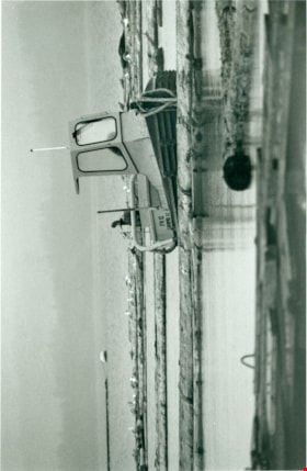
![Mountainside plank road, [190-] thumbnail](/media/hpo/_Data/_BVM_Images/1977/197900500189.jpg?width=280)
Mountainside plank road
https://search.heritageburnaby.ca/link/museumdescription446
- Repository
- Burnaby Village Museum
- Date
- [190-]
- Collection/Fonds
- Hugh H. Stewart fonds
- Description Level
- Item
- Physical Description
- 1 photograph : sepia ; 15.3 x 11.0 cm mounted on cardboard 24.5 x 17.8 cm
- Scope and Content
- Photograph of an automobile parked on the side of a plank road by a mountain rising steeply to the right of the image. An unidentified man is seen leaning on the fence at the side of the plank road.
- Repository
- Burnaby Village Museum
- Collection/Fonds
- Hugh H. Stewart fonds
- Description Level
- Item
- Physical Description
- 1 photograph : sepia ; 15.3 x 11.0 cm mounted on cardboard 24.5 x 17.8 cm
- Scope and Content
- Photograph of an automobile parked on the side of a plank road by a mountain rising steeply to the right of the image. An unidentified man is seen leaning on the fence at the side of the plank road.
- Accession Code
- HV979.50.189
- Access Restriction
- No restrictions
- Reproduction Restriction
- No known restrictions
- Date
- [190-]
- Media Type
- Photograph
- Scan Resolution
- 600
- Scan Date
- 2023-09-12
- Notes
- Title based on contents of photograph
Images
![Mountainside plank road, [190-] thumbnail](/media/hpo/_Data/_BVM_Images/1977/197900500189.jpg)

Road round 1st tunnel
https://search.heritageburnaby.ca/link/archivedescription34407
- Repository
- City of Burnaby Archives
- Date
- 1925
- Collection/Fonds
- Burnaby Historical Society fonds
- Description Level
- Item
- Physical Description
- 1 photograph : b&w ; 7 x 12.2 cm on page 17.5 x 26.5 cm
- Scope and Content
- Photographs taken in Yale, looking toward a tunnel cut through a rock face at the side of a mountain. A caption written under the photograph reads "road round [sic] 1st tunnel." This photograph appears to have been taken by Arthur Peers, who travelled through the Fraser River Valley and worked on …
- Repository
- City of Burnaby Archives
- Date
- 1925
- Collection/Fonds
- Burnaby Historical Society fonds
- Subseries
- Peers family subseries
- Physical Description
- 1 photograph : b&w ; 7 x 12.2 cm on page 17.5 x 26.5 cm
- Description Level
- Item
- Record No.
- 020-114
- Access Restriction
- No restrictions
- Reproduction Restriction
- No known restrictions
- Accession Number
- BHS2007-04
- Scope and Content
- Photographs taken in Yale, looking toward a tunnel cut through a rock face at the side of a mountain. A caption written under the photograph reads "road round [sic] 1st tunnel." This photograph appears to have been taken by Arthur Peers, who travelled through the Fraser River Valley and worked on the construction of the Trans-Provincial Highway during the later 1920s.
- Media Type
- Photograph
- Photographer
- Peers, Arthur Francis "Mike"
- Notes
- Title based on caption accompanying photograph
Images

![Roads and sidewalks, [192-] (date of original), copied 1986 thumbnail](/media/hpo/_Data/_Archives_Images/_Unrestricted/204/204-037.jpg?width=280)
Roads and sidewalks
https://search.heritageburnaby.ca/link/archivedescription35180
- Repository
- City of Burnaby Archives
- Date
- [192-] (date of original), copied 1986
- Collection/Fonds
- Burnaby Historical Society fonds
- Description Level
- Item
- Physical Description
- 1 photograph : b&w ; 12.7 x 17.8 cm print
- Scope and Content
- Photograph of dirt roads and sidewalks in Burnaby in the 1920s. George Pearson supervised cement sidewalk building throughout Burnaby during the Great Depression. St. Helen's Roman Catholic Church may be in the background.
- Repository
- City of Burnaby Archives
- Date
- [192-] (date of original), copied 1986
- Collection/Fonds
- Burnaby Historical Society fonds
- Subseries
- Pioneer Tales subseries
- Physical Description
- 1 photograph : b&w ; 12.7 x 17.8 cm print
- Description Level
- Item
- Record No.
- 204-037
- Access Restriction
- No restrictions
- Reproduction Restriction
- No known restrictions
- Accession Number
- BHS1988-03
- Scope and Content
- Photograph of dirt roads and sidewalks in Burnaby in the 1920s. George Pearson supervised cement sidewalk building throughout Burnaby during the Great Depression. St. Helen's Roman Catholic Church may be in the background.
- Subjects
- Geographic Features - Sidewalks
- Geographic Features - Roads
- Buildings - Residential - Houses
- Media Type
- Photograph
- Notes
- Title based on contents of photograph
Images
![Roads and sidewalks, [192-] (date of original), copied 1986 thumbnail](/media/hpo/_Data/_Archives_Images/_Unrestricted/204/204-037.jpg)
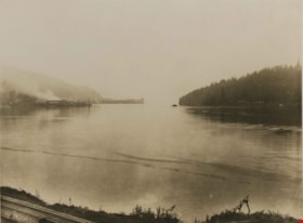
![Barnet, B.C. from the Hill, [1907] thumbnail](/media/hpo/_Data/_Archives_Images/_Unrestricted/371/411-004.jpg?width=280)
Barnet, B.C. from the Hill
https://search.heritageburnaby.ca/link/archivedescription38345
- Repository
- City of Burnaby Archives
- Date
- [1907]
- Collection/Fonds
- Burnaby Historical Society fonds
- Description Level
- Item
- Physical Description
- 1 photograph : sepia postcard ; 8 x 13 cm
- Scope and Content
- Photograph of the village of Barnet at the mill. The caption stamped at the top of the card reads: "Barnet, B.C. from the Hill." The Barnet Mill was called the North Pacific Lumber Company from 1889 to 1914.
- Repository
- City of Burnaby Archives
- Date
- [1907]
- Collection/Fonds
- Burnaby Historical Society fonds
- Subseries
- Charles Lee subseries
- Physical Description
- 1 photograph : sepia postcard ; 8 x 13 cm
- Description Level
- Item
- Record No.
- 411-004
- Access Restriction
- No restrictions
- Reproduction Restriction
- No known restrictions
- Accession Number
- BHS2000-13
- Scope and Content
- Photograph of the village of Barnet at the mill. The caption stamped at the top of the card reads: "Barnet, B.C. from the Hill." The Barnet Mill was called the North Pacific Lumber Company from 1889 to 1914.
- Subjects
- Documentary Artifacts - Postcards
- Buildings - Industrial - Mills
- Geographic Features - Inlets
- Industries - Forestry
- Industries - Logging/lumber
- Names
- Barnet Mill
- Media Type
- Photograph
- Photographer
- Timms Photographic Co.
- Notes
- Title taken from caption
- Geographic Access
- Barnet Village
- Texaco Drive
- Street Address
- 8059 Texaco Drive
- Historic Neighbourhood
- Barnet (Historic Neighbourhood)
- Planning Study Area
- Burnaby Mountain Area
Images
![Barnet, B.C. from the Hill, [1907] thumbnail](/media/hpo/_Data/_Archives_Images/_Unrestricted/371/411-004.jpg)
Boat in Burrard Inlet
https://search.heritageburnaby.ca/link/archivedescription79431
- Repository
- City of Burnaby Archives
- Date
- August 7, 1996
- Collection/Fonds
- Burnaby NewsLeader photograph collection
- Description Level
- Item
- Physical Description
- 1 photograph : b&w ; 15 x 23 cm
- Scope and Content
- Photograph of a small tugboat in the Burrard Inlet with seagulls in the background.
- Repository
- City of Burnaby Archives
- Date
- August 7, 1996
- Collection/Fonds
- Burnaby NewsLeader photograph collection
- Physical Description
- 1 photograph : b&w ; 15 x 23 cm
- Description Level
- Item
- Record No.
- 535-0377
- Access Restriction
- No restrictions
- Reproduction Restriction
- No reproduction permitted
- Accession Number
- 2012-11
- Scope and Content
- Photograph of a small tugboat in the Burrard Inlet with seagulls in the background.
- Media Type
- Photograph
- Photographer
- Blissett, Rebecca
- Notes
- Title based on contents of photograph
- Note in black ink on recto of photograph reads: "Bby 36% pg 2 / 1995 - Bby - Rebecca"
- Trim marks and/or reproduction instructions on recto (scan is cropped)
Images

Burnaby Mountain Pavilion
https://search.heritageburnaby.ca/link/archivedescription34702
- Repository
- City of Burnaby Archives
- Date
- 1958
- Collection/Fonds
- Burnaby Historical Society fonds
- Description Level
- Item
- Physical Description
- 1 photograph : b&w ; 17.4 x 20.4 cm
- Scope and Content
- Photograph of the exterior of Burnaby Mountain Pavilion with Burrard Inlet in the background.
- Repository
- City of Burnaby Archives
- Date
- 1958
- Collection/Fonds
- Burnaby Historical Society fonds
- Subseries
- Photographs subseries
- Physical Description
- 1 photograph : b&w ; 17.4 x 20.4 cm
- Description Level
- Item
- Record No.
- 107-001
- Access Restriction
- No restrictions
- Reproduction Restriction
- Reproduce for fair dealing purposes only
- Accession Number
- BHS2007-04
- Scope and Content
- Photograph of the exterior of Burnaby Mountain Pavilion with Burrard Inlet in the background.
- Media Type
- Photograph
- Notes
- Title based on contents of photograph
- Geographic Access
- Burnaby Mountain Conservation Area
- Planning Study Area
- Burnaby Mountain Area
Images

Burrard Inlet
https://search.heritageburnaby.ca/link/archivedescription34552
- Repository
- City of Burnaby Archives
- Date
- 1914
- Collection/Fonds
- Burnaby Historical Society fonds
- Description Level
- Item
- Physical Description
- 1 photograph : b&w ; 16.0 x 21.3 cm, mounted on cardboard 25.2 x 30.2 cm
- Scope and Content
- Photograph looking west along the Burrard Inlet towards Barnet. Railroad tracks can be seen in the foreground and the North Pacific Lumber Company mill can be seen in the background on the left.
- Repository
- City of Burnaby Archives
- Date
- 1914
- Collection/Fonds
- Burnaby Historical Society fonds
- Subseries
- Photographs subseries
- Physical Description
- 1 photograph : b&w ; 16.0 x 21.3 cm, mounted on cardboard 25.2 x 30.2 cm
- Description Level
- Item
- Record No.
- 044-012
- Access Restriction
- No restrictions
- Reproduction Restriction
- No known restrictions
- Accession Number
- BHS2007-04
- Scope and Content
- Photograph looking west along the Burrard Inlet towards Barnet. Railroad tracks can be seen in the foreground and the North Pacific Lumber Company mill can be seen in the background on the left.
- Subjects
- Geographic Features - Inlets
- Names
- Barnet Mill
- Media Type
- Photograph
- Notes
- Title based on contents of photograph
- Geographic Access
- Burrard Inlet
- Historic Neighbourhood
- Barnet (Historic Neighbourhood)
- Planning Study Area
- Burnaby Mountain Area
Images

Burrard Inlet
https://search.heritageburnaby.ca/link/archivedescription35599
- Repository
- City of Burnaby Archives
- Date
- 1926 (date of original), copied 1986
- Collection/Fonds
- Burnaby Historical Society fonds
- Description Level
- Item
- Physical Description
- 1 photograph : b&w ; 12.7 x 17.8 cm print
- Scope and Content
- Photograph taken from the Second Narrows Bridge looking east along Burrard Inlet with Vancouver Heights to the right and Capitol Hill in the background. The ferry boat 'Defiance' and the community of squatters shacks known as 'Crabtown' are also visible.
- Repository
- City of Burnaby Archives
- Date
- 1926 (date of original), copied 1986
- Collection/Fonds
- Burnaby Historical Society fonds
- Subseries
- Pioneer Tales subseries
- Physical Description
- 1 photograph : b&w ; 12.7 x 17.8 cm print
- Description Level
- Item
- Record No.
- 204-457
- Access Restriction
- No restrictions
- Reproduction Restriction
- No known restrictions
- Accession Number
- BHS1988-03
- Scope and Content
- Photograph taken from the Second Narrows Bridge looking east along Burrard Inlet with Vancouver Heights to the right and Capitol Hill in the background. The ferry boat 'Defiance' and the community of squatters shacks known as 'Crabtown' are also visible.
- Subjects
- Geographic Features - Inlets
- Media Type
- Photograph
- Notes
- Title based on contents of photograph
- Geographic Access
- Burrard Inlet
- Historic Neighbourhood
- Capitol Hill (Historic Neighbourhood)
- Planning Study Area
- Capitol Hill Area
Images

![Burrard Inlet, [1912] (date of original), copied 1986 thumbnail](/media/hpo/_Data/_Archives_Images/_Unrestricted/204/204-701.jpg?width=280)
Burrard Inlet
https://search.heritageburnaby.ca/link/archivedescription35842
- Repository
- City of Burnaby Archives
- Date
- [1912] (date of original), copied 1986
- Collection/Fonds
- Burnaby Historical Society fonds
- Description Level
- Item
- Physical Description
- 1 photograph : b&w ; 12.7 x 17.8 cm print
- Scope and Content
- Photograph of Burrard Inlet taken from Capitol Hill.
- Repository
- City of Burnaby Archives
- Date
- [1912] (date of original), copied 1986
- Collection/Fonds
- Burnaby Historical Society fonds
- Subseries
- Pioneer Tales subseries
- Physical Description
- 1 photograph : b&w ; 12.7 x 17.8 cm print
- Description Level
- Item
- Record No.
- 204-701
- Access Restriction
- No restrictions
- Reproduction Restriction
- No known restrictions
- Accession Number
- BHS1988-03
- Scope and Content
- Photograph of Burrard Inlet taken from Capitol Hill.
- Subjects
- Geographic Features - Inlets
- Media Type
- Photograph
- Photographer
- Phillips, James William "Jim"
- Notes
- Title based on contents of photograph
- Historic Neighbourhood
- Capitol Hill (Historic Neighbourhood)
- Planning Study Area
- Westridge Area
Images
![Burrard Inlet, [1912] (date of original), copied 1986 thumbnail](/media/hpo/_Data/_Archives_Images/_Unrestricted/204/204-701.jpg)
![Burrard Inlet, [1912] (date of original), copied 1986 thumbnail](/media/hpo/_Data/_Archives_Images/_Unrestricted/204/204-704.jpg?width=280)
Burrard Inlet
https://search.heritageburnaby.ca/link/archivedescription35845
- Repository
- City of Burnaby Archives
- Date
- [1912] (date of original), copied 1986
- Collection/Fonds
- Burnaby Historical Society fonds
- Description Level
- Item
- Physical Description
- 1 photograph : b&w ; 12.7 x 17.8 cm print
- Scope and Content
- Photograph of Burrard Inlet taken looking north from Capitol Hill.
- Repository
- City of Burnaby Archives
- Date
- [1912] (date of original), copied 1986
- Collection/Fonds
- Burnaby Historical Society fonds
- Subseries
- Pioneer Tales subseries
- Physical Description
- 1 photograph : b&w ; 12.7 x 17.8 cm print
- Description Level
- Item
- Record No.
- 204-704
- Access Restriction
- No restrictions
- Reproduction Restriction
- No known restrictions
- Accession Number
- BHS1988-03
- Scope and Content
- Photograph of Burrard Inlet taken looking north from Capitol Hill.
- Media Type
- Photograph
- Photographer
- Phillips, James William "Jim"
- Notes
- Title based on contents of photograph
- Historic Neighbourhood
- Capitol Hill (Historic Neighbourhood)
- Planning Study Area
- Capitol Hill Area
Images
![Burrard Inlet, [1912] (date of original), copied 1986 thumbnail](/media/hpo/_Data/_Archives_Images/_Unrestricted/204/204-704.jpg)
![Burrard Inlet, [1930] thumbnail](/media/hpo/_Data/_Archives_Images/_Unrestricted/371/443-005.jpg?width=280)
Burrard Inlet
https://search.heritageburnaby.ca/link/archivedescription38438
- Repository
- City of Burnaby Archives
- Date
- [1930]
- Collection/Fonds
- Burnaby Historical Society fonds
- Description Level
- Item
- Physical Description
- 1 photograph : b&w ; 6.3 x 9 cm
- Scope and Content
- Photograph looking west from 410 North Hythe Avenue towards Burrard Inlet. The Second Narrows Bridge can be seen faintly in the background.
- Repository
- City of Burnaby Archives
- Date
- [1930]
- Collection/Fonds
- Burnaby Historical Society fonds
- Subseries
- Photographs subseries
- Physical Description
- 1 photograph : b&w ; 6.3 x 9 cm
- Description Level
- Item
- Record No.
- 443-005
- Access Restriction
- No restrictions
- Reproduction Restriction
- No known restrictions
- Accession Number
- BHS2002-13
- Scope and Content
- Photograph looking west from 410 North Hythe Avenue towards Burrard Inlet. The Second Narrows Bridge can be seen faintly in the background.
- Subjects
- Geographic Features - Inlets
- Media Type
- Photograph
- Notes
- Title based on contents of photograph.
- Geographic Access
- Hythe Avenue North
- Street Address
- 410 Hythe Avenue North
- Historic Neighbourhood
- Capitol Hill (Historic Neighbourhood)
- Planning Study Area
- Capitol Hill Area
Images
![Burrard Inlet, [1930] thumbnail](/media/hpo/_Data/_Archives_Images/_Unrestricted/371/443-005.jpg)