More like 'Interview with Joanne Smith'
Narrow Results By
Subject
- Accidents - Automobile Accidents 1
- Adornment 16
- Adornment - Jewelry 1
- Adornment - Lapel Pins 16
- Advertising Medium 12
- Advertising Medium - Flyer 6
- Advertising Medium - Poster 2
- Advertising Medium - Signs and Signboards
- Aerial Photographs 37
- Agricultural Tools and Equipment 5
- Agricultural Tools and Equipment - Gardening Equipment
- Agricultural Tools and Equipment - Plows 2

Signage for Burnaby's COVID-19 drive thru testing site
https://search.heritageburnaby.ca/link/museumdescription15373
- Repository
- Burnaby Village Museum
- Date
- 5 Apr. 2020
- Collection/Fonds
- Burnaby Village Museum COVID-19 collection
- Description Level
- Item
- Physical Description
- 1 photograph (jpg)
- Scope and Content
- Photograph of portable LED signage at entrance to COVID-19 drive thru testing site in Central Park parking lot in Burnaby. LED sign reads "Sat-Sun / 12:30-5:15".
- Repository
- Burnaby Village Museum
- Collection/Fonds
- Burnaby Village Museum COVID-19 collection
- Description Level
- Item
- Physical Description
- 1 photograph (jpg)
- Scope and Content
- Photograph of portable LED signage at entrance to COVID-19 drive thru testing site in Central Park parking lot in Burnaby. LED sign reads "Sat-Sun / 12:30-5:15".
- Subjects
- Advertising Medium - Signs and Signboards
- Geographic Features - Parks
- Public Services - Health Services
- Pandemics - COVID-19
- Geographic Access
- Central Park
- Imperial Street
- Accession Code
- BV021.2.38
- Access Restriction
- No restrictions
- Reproduction Restriction
- May be restricted by third party rights
- Date
- 5 Apr. 2020
- Media Type
- Photograph
- Historic Neighbourhood
- Central Park (Historic Neighbourhood)
- Planning Study Area
- Maywood Area
- Notes
- Title based on contents of photograph
Images


Social distance in Burnaby Parks
https://search.heritageburnaby.ca/link/archivedescription95093
- Repository
- City of Burnaby Archives
- Date
- May 8, 2020
- Collection/Fonds
- Burnaby Photographic Society fonds
- Description Level
- Item
- Physical Description
- 1 photograph (tiff)
- Scope and Content
- Photograph of a City of Burnaby sign encouraging social distancing attached to a tree in Mary Avenue Park.
- Repository
- City of Burnaby Archives
- Date
- May 8, 2020
- Collection/Fonds
- Burnaby Photographic Society fonds
- Physical Description
- 1 photograph (tiff)
- Description Level
- Item
- Record No.
- 623-012
- Access Restriction
- No restrictions
- Reproduction Restriction
- Reproduce for fair dealing purposes only
- Accession Number
- 2020-10
- Scope and Content
- Photograph of a City of Burnaby sign encouraging social distancing attached to a tree in Mary Avenue Park.
- Media Type
- Photograph
- Photographer
- Asbia, Cher
- Notes
- Transcribed title
- Geographic Access
- 12th Avenue
- Historic Neighbourhood
- Edmonds (Historic Neighbourhood)
- Planning Study Area
- Edmonds Area
Images


Temporary one way at Deer Lake Park
https://search.heritageburnaby.ca/link/archivedescription95111
- Repository
- City of Burnaby Archives
- Date
- April 10, 2020
- Collection/Fonds
- Burnaby Photographic Society fonds
- Description Level
- Item
- Physical Description
- 1 photograph (tiff)
- Scope and Content
- Photograph of a sign detailing a temporary one-way walking route for Deer Lake Park. The sign is posted at the Royal Oak entrance of the park.
- Repository
- City of Burnaby Archives
- Date
- April 10, 2020
- Collection/Fonds
- Burnaby Photographic Society fonds
- Physical Description
- 1 photograph (tiff)
- Description Level
- Item
- Record No.
- 623-029
- Access Restriction
- No restrictions
- Reproduction Restriction
- No restrictions
- Accession Number
- 2020-10
- Scope and Content
- Photograph of a sign detailing a temporary one-way walking route for Deer Lake Park. The sign is posted at the Royal Oak entrance of the park.
- Media Type
- Photograph
- Photographer
- Snowdon, Nick
- Notes
- Transcribed title
- Photographer's caption: "Big signs show the one way system at Deer Lake. The signs are not detailed and lead to some confusion. Other signs are spread throughout the park including spay paint on the trails."
- Geographic Access
- Deer Lake Park
- Planning Study Area
- Windsor Area
Images


Zoey and Johan Makdessi with sign
https://search.heritageburnaby.ca/link/museumdescription14735
- Repository
- Burnaby Village Museum
- Date
- 8 Apr. 2020
- Collection/Fonds
- Burnaby Village Museum COVID-19 collection
- Description Level
- Item
- Physical Description
- 1 photograph (jpeg) : col. ; 96 dpi.
- Scope and Content
- Photograph of Zoey (left) and Johan (right) Makdessi standing behind a handpainted sign with a rainbow and hearts and the words "We miss you Teachers!" The children are standing outside on a lawn next to a sidewalk. Zoey is holding a doll.
- Repository
- Burnaby Village Museum
- Collection/Fonds
- Burnaby Village Museum COVID-19 collection
- Description Level
- Item
- Physical Description
- 1 photograph (jpeg) : col. ; 96 dpi.
- Scope and Content
- Photograph of Zoey (left) and Johan (right) Makdessi standing behind a handpainted sign with a rainbow and hearts and the words "We miss you Teachers!" The children are standing outside on a lawn next to a sidewalk. Zoey is holding a doll.
- History
- Photograph was taken on April 8 2020 for Taylor Park Elementary School Car Parade. Taylor Park staff with cars gathered at school and then drove through the neighbourhood. The principal Hal Wall organized this because he and his staff want to express their appreciation to parents trying to work from home while teaching their children. He also wanted to have a safe way to say hello and reconnect with students as well as celebrate our community all while maintaining a safe social distance at the height of uncertainty and change of the COVID-19 pandemic.
- Subjects
- Persons - Children
- Arts - Paintings
- Advertising Medium - Signs and Signboards
- Advertising Medium - Poster
- Pandemics - COVID-19
- Accession Code
- BV020.20.1
- Access Restriction
- No restrictions
- Reproduction Restriction
- No known restrictions
- Date
- 8 Apr. 2020
- Media Type
- Photograph
- Notes
- Title based on contents of photograph
Images


Deer Lake
https://search.heritageburnaby.ca/link/archivedescription91707
- Repository
- City of Burnaby Archives
- Date
- 1994-1996
- Collection/Fonds
- Doreen Lawson fonds
- Description Level
- File
- Physical Description
- 55 photographs : col. slides ; 35 mm
- Scope and Content
- File consists of scenic photographs of Deer Lake and Deer Lake Park, including closeup photographs of the lake and landscape photographs with the lake in the foreground and mountains and skyline visible in the distance. The photographs capture Deer Lake in the fall, winter, and spring. Also inclu…
- Repository
- City of Burnaby Archives
- Date
- 1994-1996
- Collection/Fonds
- Doreen Lawson fonds
- Physical Description
- 55 photographs : col. slides ; 35 mm
- Description Level
- File
- Record No.
- 618-025
- Access Restriction
- No restrictions
- Reproduction Restriction
- No restrictions
- Accession Number
- 2015-15
- Scope and Content
- File consists of scenic photographs of Deer Lake and Deer Lake Park, including closeup photographs of the lake and landscape photographs with the lake in the foreground and mountains and skyline visible in the distance. The photographs capture Deer Lake in the fall, winter, and spring. Also included in the file are four photographs of Deer Lake Park signs.
- Subjects
- Natural Phenomena - Snow
- Geographic Features - Lakes and Ponds
- Plants - Trees
- Geographic Features - Mountains
- Advertising Medium - Signs and Signboards
- Names
- Burnaby Art Gallery
- Media Type
- Photograph
- Photographer
- Lawson, Doreen A.
- Notes
- Title based on contents of photographs
- Geographic Access
- Deer Lake
- Historic Neighbourhood
- Burnaby Lake (Historic Neighbourhood)
- Planning Study Area
- Oakalla Area
Images

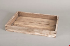
seeding tray
https://search.heritageburnaby.ca/link/museumartifact91752
- Repository
- Burnaby Village Museum
- Accession Code
- BV023.14.8
- Description
- Shallow wooden tray. The tray has three slats along the bottom with a small gap between each slat.
- The side of the tray are very worn and weathered with a white haze.
- Included with the tray are 6 thin strips of wood, almost like wood veneer, that are scored at intervals in order to form a wood plant pot. The plant pots would fit inside the tray.
- Object History
- These items belonged to the Hong family - who founded Hop On Farms in Burnaby. Heritage Burnaby has a number of photos and an oral history about the family.
- Used before plastic trays were used more regularly in the 1970s. In the 1970s, the business shifted to selling wholesale bedding plants so the plastic trays were more practical to give away. The wooden trays and pots were taken out to fields for transplanting and cleaned and reused regularly. The donors recall repairing these wooden trays over the winter months. The used the broken pots as bottoms for repaired pots.
- See BV017.36.9 on Heritage Burnaby for photograph of these in use on Hop On Farm.
- Category
- 04.Tools & Equipment for Materials
- Classification
- Agricultural T&E
- Measurements
- Length: 51.5 cm
- Width: 34.5 cm
- Depth: 7.5 cm
- Subjects
- Persons - Chinese Canadians
- Agricultural Tools and Equipment - Gardening Equipment
- Gardens
- Gardens - Market Gardens
- Names
- Hop on Farms
Images


sign
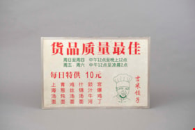
https://search.heritageburnaby.ca/link/museumartifact91627
- Repository
- Burnaby Village Museum
- Accession Code
- BV022.21.101
- Description
- Sign designed to look like a menu board for a movie prop. The board is printed on an aluminum frame dry erase board.
- The front of the board is white and has Chinese characters printed in red and green text with an illustration of a person in a chef's hat on the right side.
- The english translation is provided on the back of the board in the technical specifications.
- The technical specifications on the back include information about the scale, text colours, and movie information like director, production design, set number.
- Object History
- "Jimmy's Dumplings" prop created as part of a street scene in movie Fantastic Four 2.
- Jimmy Chow worked in TV and film as a property master for more than 42 years. A property master is responsible for building and procuring props that actors handle and use. This sometimes means making replica items that are lighter, false or make filming easier on the actor. This differs from set decoration, which uses props to create a backdrop and is less central to the action on set.
- Jimmy Chow was responsible for designing, managing, and sourcing props for films such as: BFG, Warcraft: The Beginning, X-Men 2, Fantastic Four, Watchman, Tron: Legacy, Little Women, Seven Years in Tibet, Shanghai Noon, The Shipping News, Fantastic Four: Rise of the Silver Surfer, The Changeling, Man of Steel (Superman), Snow Falling on Cedars, Legends of the Fall, And the Sea Will Tell, and Once a Thief.
- He entered the film industry in 1973 working for CBC Vancouver and gained valuable experience working on the set of the television series The Beachcombers, which launched his career.
- Category
- 08. Communication Artifacts
- Classification
- Advertising Media
- Object Term
- Sign, Advertising
- Marks/Labels
- English Translation: Best Selection / Sun-Thurs 12pm-12am / Fri-Sat 12pm-2am / Daily Specials From 10 Yuan / Shanghai Noodle Soup / Green Onion with Braised Noodles / Souple Noodles with Shredded Chicken / Fried Rice Noodles with Beef / Diced Chicken with Sauce / Jimmy Dumpling
- Names
- Chow, Hipman "Jimmy"
Images

sign
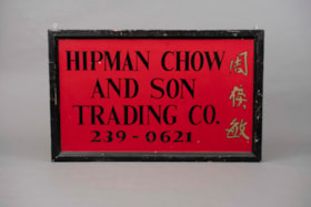
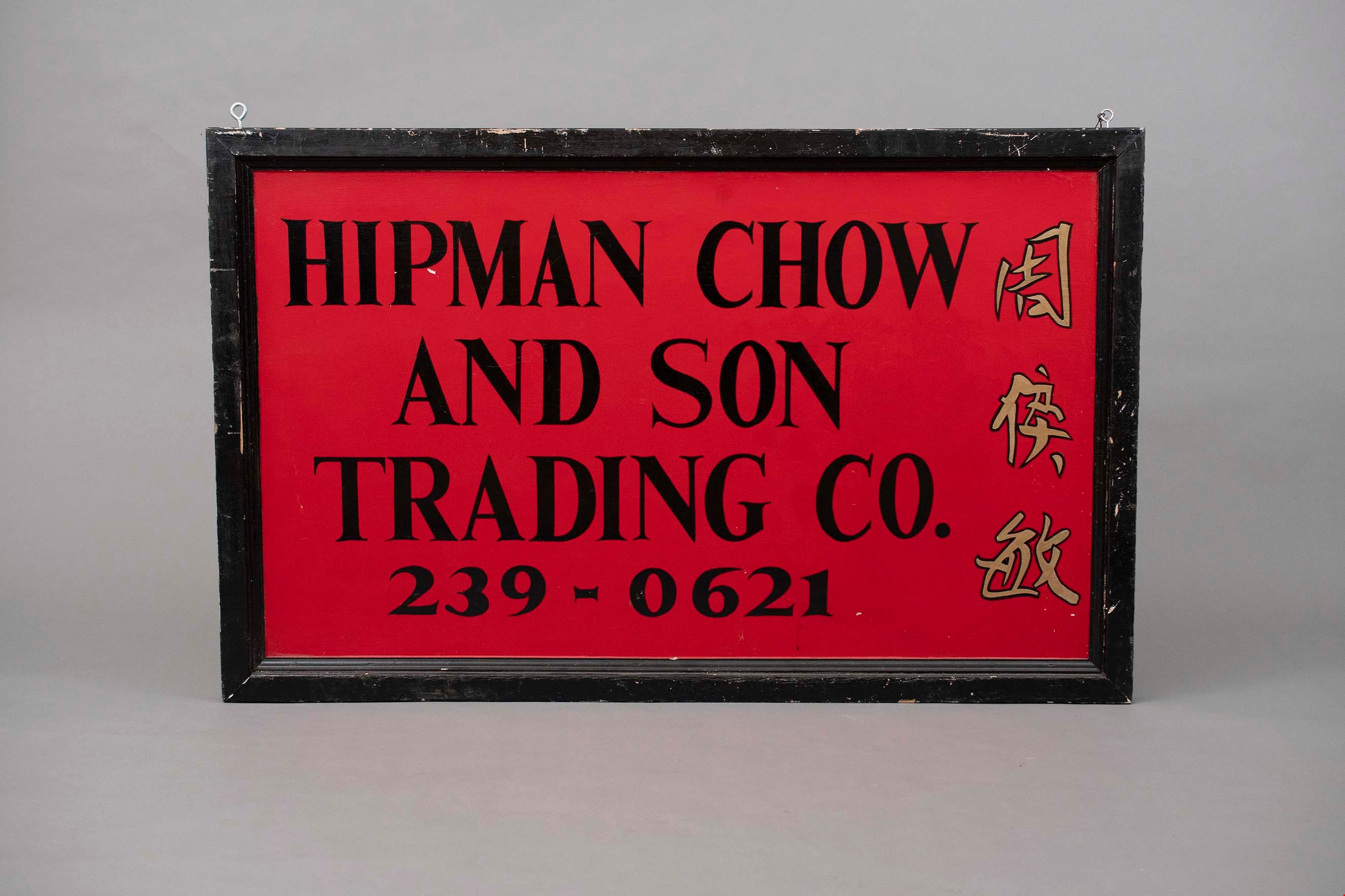
https://search.heritageburnaby.ca/link/museumartifact91632
- Repository
- Burnaby Village Museum
- Accession Code
- BV022.21.106
- Description
- Sign created to be a prop in a movie. The sign is made of wood and has text painted on both sides. The frame of the sign is painted black and distressed in areas revealing the natural wood.
- The sign itself has a red background with black text in English and Chinese characters in gold.
- There are two cup hooks at the top of the sign, each is a different size. The smaller cup hook has some wire strung through it.
- Object History
- Jimmy Chow worked in TV and film as a property master for more than 42 years. A property master is responsible for building and procuring props that actors handle and use. This sometimes means making replica items that are lighter, false or make filming easier on the actor. This differs from set decoration, which uses props to create a backdrop and is less central to the action on set.
- Jimmy Chow was responsible for designing, managing, and sourcing props for films such as: BFG, Warcraft: The Beginning, X-Men 2, Fantastic Four, Watchman, Tron: Legacy, Little Women, Seven Years in Tibet, Shanghai Noon, The Shipping News, Fantastic Four: Rise of the Silver Surfer, The Changeling, Man of Steel (Superman), Snow Falling on Cedars, Legends of the Fall, And the Sea Will Tell, and Once a Thief.
- He entered the film industry in 1973 working for CBC Vancouver and gained valuable experience working on the set of the television series The Beachcombers, which launched his career.
- Reference
- "HIPMAN CHOW / AND SON / TRADING CO. / 239-0621"
- Category
- 08. Communication Artifacts
- Classification
- Advertising Media
- Object Term
- Sign, Advertising
- Measurements
- Height: 76.5 cm
- Width: 122.5 cm
- Depth: 6.5 cm
- Names
- Chow, Hipman "Jimmy"
Images
sign
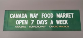
https://search.heritageburnaby.ca/link/museumartifact91782
- Repository
- Burnaby Village Museum
- Accession Code
- BV023.17.2
- Description
- Green store sign from Canada Way Food Market. Plasticized green sign with white lettering.
- There is a 2.5 cm band of residue running the length of the sign at the top and bottom.
- Object History
- Item was used in the Canada Way Food Market owned by Harry Toy between 1975 and the late 2000s. the building sat vacant until sold in 2023.
- Category
- 08. Communication Artifacts
- Classification
- Advertising Media
- Object Term
- Sign, Advertising
- Marks/Labels
- "CANADA WAY FOOD MARKET / OPEN 7 DAYS A WEEK / GROCERIES CONFECTIONARY TOBACCO PRODUCTS"
- Measurements
- Height: 49.5 cm
- Width: 176.5
- Names
- Canada Way Food Market
- Geographic Access
- Canada Way
- Street Address
- 4692 Canada Way
Images
sign
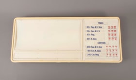
https://search.heritageburnaby.ca/link/museumartifact91783
- Repository
- Burnaby Village Museum
- Accession Code
- BV023.17.3
- Description
- Large plastic sign with internal backlighting for advertising. The sign has two sections for ad inserts and one section for price display.
- The price display is currently set up advertising the price of packs and cartons of cigarettes
- The first bank of prices are 3 digit with small windows that reveal the number on a roller behind. The second bank of prices are 4 digits.
- The sign was made by CDA Industries in Scarborough, Ontario and is stamped with "JULY 1986"
- There are three labels at the top of the sign including information about how to replace the lamps or reinsert unrolled numbers.
- There is a hole at the top of the sign for the electrical cord to come out.
- There are two white metal brackets attached to the ends of the sign and there is a rusted chain hanging from each bracket.
- The plastic at the bottom right corner on the back is broken and damaged.
- Object History
- Item was used in the Canada Way Food Market owned by Harry Toy between 1975 and the late 2000s. the building sat vacant until sold in 2023.
- See BV023.25.1 for photograph of sign in situ.
- Category
- 08. Communication Artifacts
- Classification
- Advertising Media
- Object Term
- Sign, Advertising
- Marks/Labels
- "PACKS / 20's Reg. & K. Size 5.58 / 25's Reg. & K.S. 5.58 / 30's Reg. 5.58 / 30's K. Size 5.58"
- "CARTONS / 200 Reg. & K.Size 11.11 / 180 Ctn. K. Size 11.11 / 240 Ctn. Reg. 11.11"
- Measurements
- Height: 57.5 cm
- Width: 133.5 cm
- Depth: 13 cm
- Names
- Canada Way Food Market
- Geographic Access
- Canada Way
- Street Address
- 4692 Canada Way
Images
sign
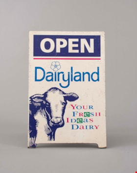
https://search.heritageburnaby.ca/link/museumartifact91784
- Repository
- Burnaby Village Museum
- Accession Code
- BV023.17.4
- Description
- Wooden sandwich board advertising Dairyland products. The board consists of two wooden panels that were attached at the top with a piano hinge. The hinge is currently only attached to one panel. The wooden panels are painted white. The paint is chipping in many areas.
- Both panels feature the same information and have an large illustration of a cow's head an front body on the bottom left.
- The two panels are held together on the back with a rusty metal chain.
- Handwritten on the back of one of the panels is "Canada Way Food Market"
- Object History
- Item was used in the Canada Way Food Market owned by Harry Toy between 1975 and the late 2000s. the building sat vacant until sold in 2023.
- Category
- 08. Communication Artifacts
- Classification
- Advertising Media
- Object Term
- Sign, Advertising
- Marks/Labels
- "OPEN / Dairyland / Your / Fresh / Ideas / Dairy"
- Measurements
- Height: 74.5 cm
- Width: 49 cm
- Names
- Canada Way Food Market
- Geographic Access
- Canada Way
- Street Address
- 4692 Canada Way
Images

2761 North Rd
https://search.heritageburnaby.ca/link/archivedescription94334
- Repository
- City of Burnaby Archives
- Date
- April 1995
- Collection/Fonds
- Grover, Elliott & Co. Ltd. fonds
- Description Level
- File
- Physical Description
- 24 photographs : col. negatives ; 35 mm
- Scope and Content
- Photographs of an undeveloped property located at 2761 North Road - an address that no longer exists. Three large billboards are posted at the edge of the property, facing onto the street.
- Repository
- City of Burnaby Archives
- Date
- April 1995
- Collection/Fonds
- Grover, Elliott & Co. Ltd. fonds
- Physical Description
- 24 photographs : col. negatives ; 35 mm
- Description Level
- File
- Record No.
- 622-119
- Access Restriction
- No restrictions
- Reproduction Restriction
- No restrictions
- Accession Number
- 2017-39
- Scope and Content
- Photographs of an undeveloped property located at 2761 North Road - an address that no longer exists. Three large billboards are posted at the edge of the property, facing onto the street.
- Media Type
- Photograph
- Photographer
- Young, Richard
- Notes
- Transcribed title
- Title transcribed from envelope photographs were originally housed in
- File no. 95-167-B
- Geographic Access
- North Road
- Historic Neighbourhood
- Burquitlam (Historic Neighbourhood)
- Planning Study Area
- Lyndhurst Area
4250 Grange St
https://search.heritageburnaby.ca/link/archivedescription93892
- Repository
- City of Burnaby Archives
- Date
- June 1993
- Collection/Fonds
- Grover, Elliott & Co. Ltd. fonds
- Description Level
- File
- Physical Description
- 25 photographs : col. negatives ; 35 mm
- Scope and Content
- Photographs of an undeveloped property located at 4250 Grange Street - an address that no longer exists. The property's current address is 5833 Wilson Avenue. A billboard in front of the property reads: Paramount / Coming Soon / Two 21-Storey Luxury Twin Towers".
- Repository
- City of Burnaby Archives
- Date
- June 1993
- Collection/Fonds
- Grover, Elliott & Co. Ltd. fonds
- Physical Description
- 25 photographs : col. negatives ; 35 mm
- Description Level
- File
- Record No.
- 622-075
- Access Restriction
- No restrictions
- Reproduction Restriction
- No restrictions
- Accession Number
- 2017-39
- Scope and Content
- Photographs of an undeveloped property located at 4250 Grange Street - an address that no longer exists. The property's current address is 5833 Wilson Avenue. A billboard in front of the property reads: Paramount / Coming Soon / Two 21-Storey Luxury Twin Towers".
- Media Type
- Photograph
- Notes
- Transcribed title
- Title transcribed from envelope photographs were originally housed in
- File no. 93-284-B
- Photographer identified as "J.C."
- Geographic Access
- Wilson Avenue
- Grange Street
- Street Address
- 5833 Wilson Avenue
- Historic Neighbourhood
- Central Park (Historic Neighbourhood)
- Planning Study Area
- Garden Village Area
![Blythe Eagles in the garden, [1930] (date of original), copied 1996 thumbnail](/media/hpo/_Data/_Archives_Images/_Unrestricted/316/331-001.jpg?width=280)
Blythe Eagles in the garden
https://search.heritageburnaby.ca/link/archivedescription37183
- Repository
- City of Burnaby Archives
- Date
- [1930] (date of original), copied 1996
- Collection/Fonds
- Burnaby Historical Society fonds
- Description Level
- Item
- Physical Description
- 1 photograph : b&w ; 16.5 x 10 cm print
- Scope and Content
- Photograph of Blythe Eagles with his shirt off, working in the garden.
- Repository
- City of Burnaby Archives
- Date
- [1930] (date of original), copied 1996
- Collection/Fonds
- Burnaby Historical Society fonds
- Subseries
- Eagles family subseries
- Physical Description
- 1 photograph : b&w ; 16.5 x 10 cm print
- Description Level
- Item
- Record No.
- 331-001
- Access Restriction
- No restrictions
- Reproduction Restriction
- No known restrictions
- Accession Number
- BHS1996-21
- Scope and Content
- Photograph of Blythe Eagles with his shirt off, working in the garden.
- Names
- Eagles, Dr. Blythe
- Media Type
- Photograph
- Notes
- Title based on contents of photograph
- Geographic Access
- Sperling Avenue
- Street Address
- 5655 Sperling Avenue
- Historic Neighbourhood
- Burnaby Lake (Historic Neighbourhood)
- Planning Study Area
- Morley-Buckingham Area
Images
![Blythe Eagles in the garden, [1930] (date of original), copied 1996 thumbnail](/media/hpo/_Data/_Archives_Images/_Unrestricted/316/331-001.jpg)

Burnaby hospital closes main entrance
https://search.heritageburnaby.ca/link/archivedescription95094
- Repository
- City of Burnaby Archives
- Date
- April 6, 2020
- Collection/Fonds
- Burnaby Photographic Society fonds
- Description Level
- Item
- Physical Description
- 1 photograph (tiff)
- Scope and Content
- Photograph of a rerouting sign posted to a sandwich board outside the Burnaby Hospital emergency lot. The sign states that the hospital entrance is closed and requests visitors use the Main Entrance of the hospital.
- Repository
- City of Burnaby Archives
- Date
- April 6, 2020
- Collection/Fonds
- Burnaby Photographic Society fonds
- Physical Description
- 1 photograph (tiff)
- Description Level
- Item
- Record No.
- 623-013
- Access Restriction
- No restrictions
- Reproduction Restriction
- No restrictions
- Accession Number
- 2020-10
- Scope and Content
- Photograph of a rerouting sign posted to a sandwich board outside the Burnaby Hospital emergency lot. The sign states that the hospital entrance is closed and requests visitors use the Main Entrance of the hospital.
- Subjects
- Buildings - Civic - Hospitals
- Geographic Features - Automobile Parking Lots
- Advertising Medium - Signs and Signboards
- Media Type
- Photograph
- Photographer
- Damer, Eric
- Notes
- Transcribed title
- Geographic Access
- Kincaid Street
- Street Address
- 3935 Kincaid Street
- Historic Neighbourhood
- Broadview (Historic Neighbourhood)
- Planning Study Area
- Cascade-Schou Area
Images

![Caila Anderson with traffic signs, [2000] thumbnail](/media/hpo/_Data/_Archives_Images/_Unrestricted/535/535-2547.jpg?width=280)
Caila Anderson with traffic signs
https://search.heritageburnaby.ca/link/archivedescription97015
- Repository
- City of Burnaby Archives
- Date
- [2000]
- Collection/Fonds
- Burnaby NewsLeader photograph collection
- Description Level
- Item
- Physical Description
- 1 photograph (tiff) : col.
- Scope and Content
- Photograph of Caila Anderson, an employee of International SPFX, standing with her arms crossed next to two traffic signs on Greenwood Street.
- Repository
- City of Burnaby Archives
- Date
- [2000]
- Collection/Fonds
- Burnaby NewsLeader photograph collection
- Physical Description
- 1 photograph (tiff) : col.
- Description Level
- Item
- Record No.
- 535-2547
- Access Restriction
- No restrictions
- Reproduction Restriction
- No restrictions
- Accession Number
- 2018-12
- Scope and Content
- Photograph of Caila Anderson, an employee of International SPFX, standing with her arms crossed next to two traffic signs on Greenwood Street.
- Subjects
- Planning - City Planning
- Advertising Medium - Signs and Signboards
- Geographic Features - Roads
- Media Type
- Photograph
- Photographer
- Bartel, Mario
- Notes
- Title based on caption
- Collected by editorial for use in a July 2000 issue of the Burnaby NewsLeader
- Caption from metadata: "Caila Anderson, of International SPFX, says new traffic regulations on Greenwood St. have made it really inconvenient for employees at the movie special effects company to get to and from their production offices. Residents on the street say the regulations haven't gone far enough."
- Geographic Access
- Greenwood Street
- Historic Neighbourhood
- Lozells (Historic Neighbourhood)
- Planning Study Area
- Government Road Area
Images
![Caila Anderson with traffic signs, [2000] thumbnail](/media/hpo/_Data/_Archives_Images/_Unrestricted/535/535-2547.jpg)

Crossing Royal Oak & Rumble Street
https://search.heritageburnaby.ca/link/archivedescription93686
- Repository
- City of Burnaby Archives
- Date
- May 19, 1978
- Collection/Fonds
- Burnaby Public Library Contemporary Visual Archive Project
- Description Level
- Item
- Physical Description
- 1 photograph : b&w ; 12.5 x 17.5 cm
- Scope and Content
- Photograph of the intersection of Royal Oak Avenue and Rumble Street. Cars and pedestrians are crossing the intersection, and the signs for businesses TD Bank, Standard Oil/Chevron gas station, Gulf gas station, and Baxter's Market are visible. The photograph is taken from a corner of the intersect…
- Repository
- City of Burnaby Archives
- Date
- May 19, 1978
- Collection/Fonds
- Burnaby Public Library Contemporary Visual Archive Project
- Physical Description
- 1 photograph : b&w ; 12.5 x 17.5 cm
- Description Level
- Item
- Record No.
- 556-643
- Access Restriction
- No restrictions
- Reproduction Restriction
- Reproduce for fair dealing purposes only
- Accession Number
- 2017-57
- Scope and Content
- Photograph of the intersection of Royal Oak Avenue and Rumble Street. Cars and pedestrians are crossing the intersection, and the signs for businesses TD Bank, Standard Oil/Chevron gas station, Gulf gas station, and Baxter's Market are visible. The photograph is taken from a corner of the intersection, facing southeast.
- Subjects
- Geographic Features - Roads
- Advertising Medium - Signs and Signboards
- Buildings - Commercial - Service Stations
- Transportation - Automobiles
- Buildings - Commercial
- Media Type
- Photograph
- Photographer
- van Mannen, Mark
- Notes
- Title taken from project information form
- Accompanied by a project information form and 1 photograph (b&w negative ; 9.5 x 12.5 cm)
- BPL no. 91
- Geographic Access
- Royal Oak Avenue
- Rumble Street
- Historic Neighbourhood
- Alta Vista (Historic Neighbourhood)
- Planning Study Area
- Sussex-Nelson Area
Images


Crossing Royal Oak & Rumble Street
https://search.heritageburnaby.ca/link/archivedescription93687
- Repository
- City of Burnaby Archives
- Date
- May 19, 1978
- Collection/Fonds
- Burnaby Public Library Contemporary Visual Archive Project
- Description Level
- Item
- Physical Description
- 1 photograph : b&w ; 12.5 x 17.5 cm
- Scope and Content
- Photograph of the intersection of Royal Oak Avenue and Rumble Street. Cars and pedestrians are crossing the intersection, and the signs for businesses Grace United Pharmacy, Standard Oil/Chevron gas station, Gulf gas station, and Royal Meats are visible. The photograph is taken from the Gulf gas st…
- Repository
- City of Burnaby Archives
- Date
- May 19, 1978
- Collection/Fonds
- Burnaby Public Library Contemporary Visual Archive Project
- Physical Description
- 1 photograph : b&w ; 12.5 x 17.5 cm
- Description Level
- Item
- Record No.
- 556-644
- Access Restriction
- No restrictions
- Reproduction Restriction
- Reproduce for fair dealing purposes only
- Accession Number
- 2017-57
- Scope and Content
- Photograph of the intersection of Royal Oak Avenue and Rumble Street. Cars and pedestrians are crossing the intersection, and the signs for businesses Grace United Pharmacy, Standard Oil/Chevron gas station, Gulf gas station, and Royal Meats are visible. The photograph is taken from the Gulf gas station parking lot, facing northwest.
- Subjects
- Advertising Medium - Signs and Signboards
- Geographic Features - Roads
- Transportation - Automobiles
- Buildings - Commercial
- Buildings - Commercial - Service Stations
- Media Type
- Photograph
- Photographer
- van Mannen, Mark
- Notes
- Title taken from project information form
- Accompanied by a project information form and 1 photograph (b&w negative ; 9.5 x 12.5 cm)
- BPL no. 92
- Geographic Access
- Royal Oak Avenue
- Rumble Street
- Historic Neighbourhood
- Alta Vista (Historic Neighbourhood)
- Planning Study Area
- Sussex-Nelson Area
Images

George Grant
https://search.heritageburnaby.ca/link/archivedescription36903
- Repository
- City of Burnaby Archives
- Date
- 1918 (date of original), copied 1992
- Collection/Fonds
- Burnaby Historical Society fonds
- Description Level
- Item
- Physical Description
- 1 photograph : b&w ; 7.9 x 11.8 cm print
- Scope and Content
- Photograph of George Grant holding a rake for garden chores at 2540 Marlborough Avenue. The woman in the background may be his mother, Alice Grant.
- Repository
- City of Burnaby Archives
- Date
- 1918 (date of original), copied 1992
- Collection/Fonds
- Burnaby Historical Society fonds
- Subseries
- Burnaby Centennial Anthology subseries
- Physical Description
- 1 photograph : b&w ; 7.9 x 11.8 cm print
- Description Level
- Item
- Record No.
- 315-361
- Access Restriction
- No restrictions
- Reproduction Restriction
- No known restrictions
- Accession Number
- BHS1994-04
- Scope and Content
- Photograph of George Grant holding a rake for garden chores at 2540 Marlborough Avenue. The woman in the background may be his mother, Alice Grant.
- Media Type
- Photograph
- Notes
- Title based on contents of photograph
- Geographic Access
- Marlborough Avenue
- Street Address
- 6591 Marlborough Avenue
- Historic Neighbourhood
- Central Park (Historic Neighbourhood)
- Planning Study Area
- Marlborough Area
Images

![Granville Street, Vancouver, [1910] thumbnail](/media/hpo/_Data/_BVM_Images/1972/1972_0050_0008_001.jpg?width=280)
Granville Street, Vancouver
https://search.heritageburnaby.ca/link/museumdescription1069
- Repository
- Burnaby Village Museum
- Date
- [1910]
- Collection/Fonds
- Burnaby Village Museum Photograph collection
- Description Level
- Item
- Physical Description
- 1 photograph : b&w ; 7.4 x 9.8 cm
- Scope and Content
- Photograph of Granville Street, looking north. Signs for "Fletchers Pianos" and the "Colonial Theatre" can be seen. The north shore is faintly visible across Burrard Inlet.
- Repository
- Burnaby Village Museum
- Collection/Fonds
- Burnaby Village Museum Photograph collection
- Description Level
- Item
- Physical Description
- 1 photograph : b&w ; 7.4 x 9.8 cm
- Scope and Content
- Photograph of Granville Street, looking north. Signs for "Fletchers Pianos" and the "Colonial Theatre" can be seen. The north shore is faintly visible across Burrard Inlet.
- Subjects
- Advertising Medium - Signs and Signboards
- Buildings - Commercial
- Geographic Features - Roads
- Geographic Access
- Vancouver
- Accession Code
- HV972.50.8
- Access Restriction
- No restrictions
- Reproduction Restriction
- No known restrictions
- Date
- [1910]
- Media Type
- Photograph
- Scan Resolution
- 600
- Scan Date
- 2023-04-04
- Photographer
- Dean, H.M.
- Notes
- Title based on contents of photograph
- An annotation on the back of the photograph reads, "Granville St. - 1910."
Images
![Granville Street, Vancouver, [1910] thumbnail](/media/hpo/_Data/_BVM_Images/1972/1972_0050_0008_001.jpg)