More like 'Interview with Charmaine Bayntun by Eric Damer October 22, 2012 - Track 2'
Narrow Results By
Subject
- Accidents - Automobile Accidents
- Advertising Medium 7
- Advertising Medium - Flyer 6
- Advertising Medium - Signs and Signboards
- Aerial Photographs 36
- Agricultural Tools and Equipment
- Agricultural Tools and Equipment - Gardening Equipment 6
- Agricultural Tools and Equipment - Plows 2
- Agriculture 9
- Agriculture - Crops 1
- Agriculture - Farms 21
- Agriculture - Fruit and Berries 3
![Gardening techniques, [1963] (date of original), digitally copied 2012 thumbnail](/media/hpo/_Data/_Archives_Images/_Unrestricted/540/549-035.jpg?width=280)
Gardening techniques
https://search.heritageburnaby.ca/link/archivedescription76915
- Repository
- City of Burnaby Archives
- Date
- [1963] (date of original), digitally copied 2012
- Collection/Fonds
- Community Heritage Commission Special Projects fonds
- Description Level
- Item
- Physical Description
- 1 photograph (jpeg) : col. ; 300ppi
- Scope and Content
- Photograph of Tony Fabian using new gardening techniques to improve his garden at Hardwick Street.
- Repository
- City of Burnaby Archives
- Date
- [1963] (date of original), digitally copied 2012
- Collection/Fonds
- Community Heritage Commission Special Projects fonds
- Physical Description
- 1 photograph (jpeg) : col. ; 300ppi
- Description Level
- Item
- Record No.
- 549-035
- Access Restriction
- No restrictions
- Reproduction Restriction
- Reproduce for fair dealing purposes only
- Accession Number
- 2012-30
- Scope and Content
- Photograph of Tony Fabian using new gardening techniques to improve his garden at Hardwick Street.
- Names
- Fabian, Tony S.
- Media Type
- Photograph
- Notes
- Title based on contents of photograph
- Geographic Access
- Hardwick Street
- Planning Study Area
- Douglas-Gilpin Area
Images
![Gardening techniques, [1963] (date of original), digitally copied 2012 thumbnail](/media/hpo/_Data/_Archives_Images/_Unrestricted/540/549-035.jpg)

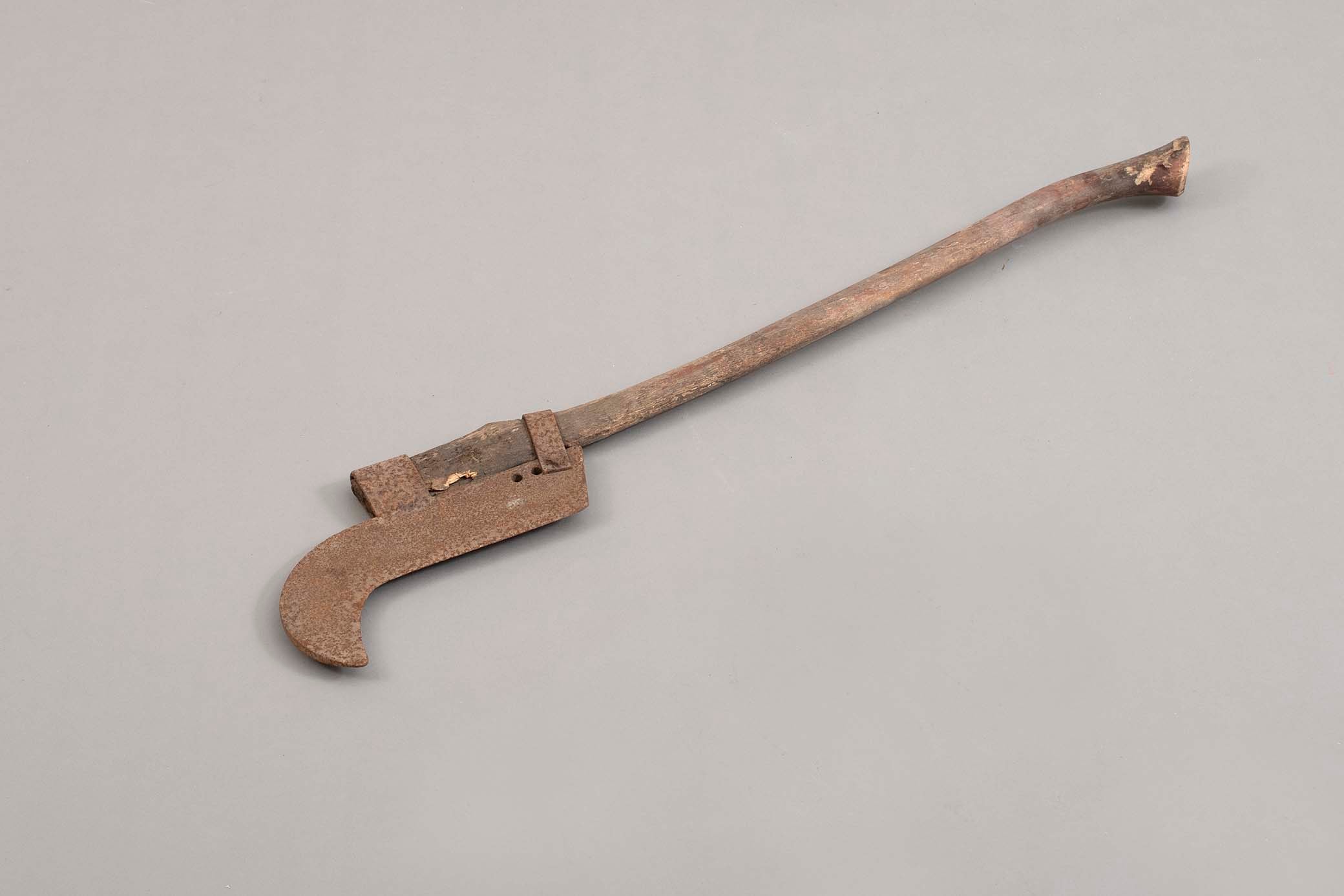
brush hook
https://search.heritageburnaby.ca/link/museumartifact91750
- Repository
- Burnaby Village Museum
- Accession Code
- BV023.14.6
- Description
- Tool with a hooked blade attached to a long wooden handle used for land clearing - cut heavy brush, shrubs, or small trees.
- The blade is made of iron and is heavily rusted. The handle is damaged in several spots and cracked where the blade is attached.
- Object History
- These items belonged to the Hong family - who founded Hop On Farms in Burnaby. Heritage Burnaby has a number of photos and an oral history about the family.
- Classification
- Maintenance T&E - - Groundskeeping Equipment
- Object Term
- Hook, Brush
- Measurements
- Length: 92 cm
- Subjects
- Persons - Chinese Canadians
- Agricultural Tools and Equipment
- Gardens
- Gardens - Market Gardens
- Names
- Hop on Farms
Images

raffia bundle
https://search.heritageburnaby.ca/link/museumartifact91753
- Repository
- Burnaby Village Museum
- Accession Code
- BV023.14.9
- Description
- Bundle of raffia strands twisted into a bundle. The bundle is held together at the top by a strip of raffia and is knotted around itself at the bottom.
- Object History
- These items belonged to the Hong family - who founded Hop On Farms in Burnaby. Heritage Burnaby has a number of photos and an oral history about the family.
- Raffia bundle, used for tying vegetables in the fields. *We have a photo of raffia ties in use at Hop On Farm: BV017.36.7
- Measurements
- Length: 138 cm
- Subjects
- Persons - Chinese Canadians
- Agricultural Tools and Equipment
- Gardens
- Gardens - Market Gardens
- Names
- Hop on Farms
Images

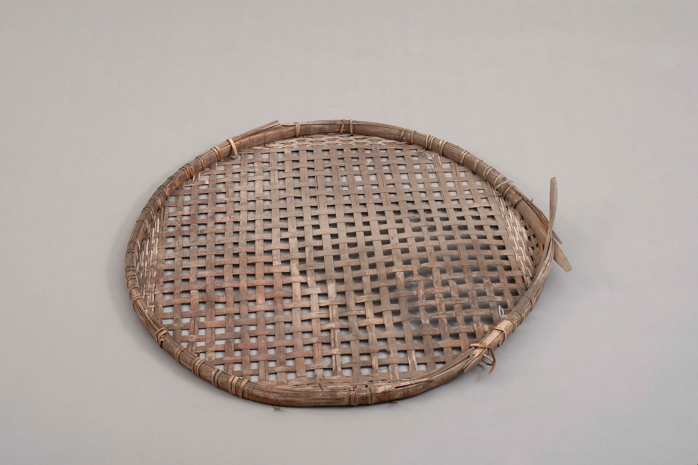
seed drying tray
https://search.heritageburnaby.ca/link/museumartifact91757
- Repository
- Burnaby Village Museum
- Accession Code
- BV023.14.12
- Description
- Large wooden hoop frame with thin slats of wood woven across it. This creates a shallow tray on one side of the hoop. The hoop is held together by ties around the hoop itself. Some of the ties have broken causing the hoop to come apart.
- The hoop and weave are very brittle.
- Object History
- These items belonged to the Hong family - who founded Hop On Farms in Burnaby. Heritage Burnaby has a number of photos and an oral history about the family.
- Seed drying tray, used when the family saved their own seed. They saved their seed to have a reliable supply of vegetable seeds difficult to find through the 1970s, 1980s and 1990s: choi sum, gai lan, bok choi. The seed heads were clipped and placed on the tray, and stored in the greenhouses to dry down. A finer sieve would have been used to separate the seeds from the chaff.
- Category
- 04.Tools & Equipment for Materials
- Classification
- Agricultural T&E
- Measurements
- Diameter: 86 cm
- Subjects
- Persons - Chinese Canadians
- Agricultural Tools and Equipment
- Gardens
- Gardens - Market Gardens
- Names
- Hop on Farms
Images

Reconstructed Central Park Band Stand
https://search.heritageburnaby.ca/link/archivedescription95123
- Repository
- City of Burnaby Archives
- Date
- May 28, 2020
- Collection/Fonds
- Burnaby Photographic Society fonds
- Description Level
- Item
- Physical Description
- 1 photograph (tiff)
- Scope and Content
- Photograph of the band stand in Central Park. The band stand stairs are blocked off with orange netting and a City of Burnaby facility closure sign.
- Repository
- City of Burnaby Archives
- Date
- May 28, 2020
- Collection/Fonds
- Burnaby Photographic Society fonds
- Physical Description
- 1 photograph (tiff)
- Description Level
- Item
- Record No.
- 623-041
- Access Restriction
- No restrictions
- Reproduction Restriction
- No restrictions
- Accession Number
- 2020-10
- Scope and Content
- Photograph of the band stand in Central Park. The band stand stairs are blocked off with orange netting and a City of Burnaby facility closure sign.
- Subjects
- Buildings - Recreational - Bandstands
- Geographic Features - Parks
- Advertising Medium - Signs and Signboards
- Media Type
- Photograph
- Photographer
- Cheung, Ray
- Notes
- Transcribed title
- Geographic Access
- Central Park
- Imperial Street
- Street Address
- 3883 Imperial Street
- Historic Neighbourhood
- Central Park (Historic Neighbourhood)
- Planning Study Area
- Maywood Area
Images


Central Park testing station
https://search.heritageburnaby.ca/link/archivedescription95101
- Repository
- City of Burnaby Archives
- Date
- May 9, 2020
- Collection/Fonds
- Burnaby Photographic Society fonds
- Description Level
- Item
- Physical Description
- 1 photograph (tiff)
- Scope and Content
- Photograph of the COVID-19 testing station located in the Central Park parking lot off Boundary Road. A sign in the foreground reads "Covid-19 Care Site by Referral Only / Walk in Access". In the background, the white tents of the testing station are visible.
- Repository
- City of Burnaby Archives
- Date
- May 9, 2020
- Collection/Fonds
- Burnaby Photographic Society fonds
- Physical Description
- 1 photograph (tiff)
- Description Level
- Item
- Record No.
- 623-019
- Access Restriction
- No restrictions
- Reproduction Restriction
- No restrictions
- Accession Number
- 2020-10
- Scope and Content
- Photograph of the COVID-19 testing station located in the Central Park parking lot off Boundary Road. A sign in the foreground reads "Covid-19 Care Site by Referral Only / Walk in Access". In the background, the white tents of the testing station are visible.
- Subjects
- Geographic Features - Parks
- Geographic Features - Automobile Parking Lots
- Advertising Medium - Signs and Signboards
- Structures - Tents
- Media Type
- Photograph
- Photographer
- Damer, Eric
- Notes
- Transcribed title
- Geographic Access
- Boundary Road
- Central Park
- Historic Neighbourhood
- Central Park (Historic Neighbourhood)
- Planning Study Area
- Maywood Area
Images


Deer Lake
https://search.heritageburnaby.ca/link/archivedescription91707
- Repository
- City of Burnaby Archives
- Date
- 1994-1996
- Collection/Fonds
- Doreen Lawson fonds
- Description Level
- File
- Physical Description
- 55 photographs : col. slides ; 35 mm
- Scope and Content
- File consists of scenic photographs of Deer Lake and Deer Lake Park, including closeup photographs of the lake and landscape photographs with the lake in the foreground and mountains and skyline visible in the distance. The photographs capture Deer Lake in the fall, winter, and spring. Also inclu…
- Repository
- City of Burnaby Archives
- Date
- 1994-1996
- Collection/Fonds
- Doreen Lawson fonds
- Physical Description
- 55 photographs : col. slides ; 35 mm
- Description Level
- File
- Record No.
- 618-025
- Access Restriction
- No restrictions
- Reproduction Restriction
- No restrictions
- Accession Number
- 2015-15
- Scope and Content
- File consists of scenic photographs of Deer Lake and Deer Lake Park, including closeup photographs of the lake and landscape photographs with the lake in the foreground and mountains and skyline visible in the distance. The photographs capture Deer Lake in the fall, winter, and spring. Also included in the file are four photographs of Deer Lake Park signs.
- Subjects
- Natural Phenomena - Snow
- Geographic Features - Lakes and Ponds
- Plants - Trees
- Geographic Features - Mountains
- Advertising Medium - Signs and Signboards
- Names
- Burnaby Art Gallery
- Media Type
- Photograph
- Photographer
- Lawson, Doreen A.
- Notes
- Title based on contents of photographs
- Geographic Access
- Deer Lake
- Historic Neighbourhood
- Burnaby Lake (Historic Neighbourhood)
- Planning Study Area
- Oakalla Area
Images


COVID-19 signage outside of Burnaby Mountain Golf Course
https://search.heritageburnaby.ca/link/museumdescription15359
- Repository
- Burnaby Village Museum
- Date
- 6 May 2020
- Collection/Fonds
- Burnaby Village Museum COVID-19 collection
- Description Level
- Item
- Physical Description
- 1 photograph (jpg)
- Scope and Content
- Photograph of COVID-19 signage outside of the Burnaby Mountain Golf Course and Driving Range. Sandwhich board sign reads: "Check In / Attention Golfers / We request that all golfers / stay in the parking lot area / until 15 minutes prior to their tea time".
- Repository
- Burnaby Village Museum
- Collection/Fonds
- Burnaby Village Museum COVID-19 collection
- Description Level
- Item
- Physical Description
- 1 photograph (jpg)
- Scope and Content
- Photograph of COVID-19 signage outside of the Burnaby Mountain Golf Course and Driving Range. Sandwhich board sign reads: "Check In / Attention Golfers / We request that all golfers / stay in the parking lot area / until 15 minutes prior to their tea time".
- Subjects
- Advertising Medium - Signs and Signboards
- Recreational Activities - Golf
- Pandemics - COVID-19
- Geographic Access
- Halifax Street
- Street Address
- 7600 Halifax Street
- Accession Code
- BV021.2.21
- Access Restriction
- No restrictions
- Reproduction Restriction
- May be restricted by third party rights
- Date
- 6 May 2020
- Media Type
- Photograph
- Historic Neighbourhood
- Lochdale (Historic Neighbourhood)
- Planning Study Area
- Sperling-Broadway Area
- Notes
- Title based on contents of photograph
Images


COVID-19 signage outside of Burnaby Mountain Golf Course
https://search.heritageburnaby.ca/link/museumdescription15360
- Repository
- Burnaby Village Museum
- Date
- 6 May 2020
- Collection/Fonds
- Burnaby Village Museum COVID-19 collection
- Description Level
- Item
- Physical Description
- 1 photograph (jpg)
- Scope and Content
- Photograph of COVID-19 signage outside of the Burnaby Mountain Golf Course and Driving Range. Sign located in front garden at entrance road to the golf course reads: "Do Your Part / Stay Apart..." and includes an illustration of two figures standing two metres apart.
- Repository
- Burnaby Village Museum
- Collection/Fonds
- Burnaby Village Museum COVID-19 collection
- Description Level
- Item
- Physical Description
- 1 photograph (jpg)
- Scope and Content
- Photograph of COVID-19 signage outside of the Burnaby Mountain Golf Course and Driving Range. Sign located in front garden at entrance road to the golf course reads: "Do Your Part / Stay Apart..." and includes an illustration of two figures standing two metres apart.
- Subjects
- Advertising Medium - Signs and Signboards
- Recreational Activities - Golf
- Pandemics - COVID-19
- Geographic Access
- Halifax Street
- Street Address
- 7600 Halifax Street
- Accession Code
- BV021.2.22
- Access Restriction
- No restrictions
- Reproduction Restriction
- May be restricted by third party rights
- Date
- 6 May 2020
- Media Type
- Photograph
- Historic Neighbourhood
- Lochdale (Historic Neighbourhood)
- Planning Study Area
- Sperling-Broadway Area
- Notes
- Title based on contents of photograph
Images


COVID-19 signage outside of Burnaby Mountain Golf Course
https://search.heritageburnaby.ca/link/museumdescription15361
- Repository
- Burnaby Village Museum
- Date
- 6 May 2020
- Collection/Fonds
- Burnaby Village Museum COVID-19 collection
- Description Level
- Item
- Physical Description
- 1 photograph (jpg)
- Scope and Content
- Photograph of COVID-19 signage at the Burnaby Mountain Golf Course and Driving Range. Signage is hanging on roped off area outside of putting greens near the clubhouse. Signs read "Practice Greens / Closed".
- Repository
- Burnaby Village Museum
- Collection/Fonds
- Burnaby Village Museum COVID-19 collection
- Description Level
- Item
- Physical Description
- 1 photograph (jpg)
- Scope and Content
- Photograph of COVID-19 signage at the Burnaby Mountain Golf Course and Driving Range. Signage is hanging on roped off area outside of putting greens near the clubhouse. Signs read "Practice Greens / Closed".
- Subjects
- Advertising Medium - Signs and Signboards
- Recreational Activities - Golf
- Pandemics - COVID-19
- Geographic Access
- Halifax Street
- Street Address
- 7600 Halifax Street
- Accession Code
- BV021.2.23
- Access Restriction
- No restrictions
- Reproduction Restriction
- May be restricted by third party rights
- Date
- 6 May 2020
- Media Type
- Photograph
- Historic Neighbourhood
- Lochdale (Historic Neighbourhood)
- Planning Study Area
- Sperling-Broadway Area
- Notes
- Title based on contents of photograph
Images

2761 North Rd
https://search.heritageburnaby.ca/link/archivedescription94334
- Repository
- City of Burnaby Archives
- Date
- April 1995
- Collection/Fonds
- Grover, Elliott & Co. Ltd. fonds
- Description Level
- File
- Physical Description
- 24 photographs : col. negatives ; 35 mm
- Scope and Content
- Photographs of an undeveloped property located at 2761 North Road - an address that no longer exists. Three large billboards are posted at the edge of the property, facing onto the street.
- Repository
- City of Burnaby Archives
- Date
- April 1995
- Collection/Fonds
- Grover, Elliott & Co. Ltd. fonds
- Physical Description
- 24 photographs : col. negatives ; 35 mm
- Description Level
- File
- Record No.
- 622-119
- Access Restriction
- No restrictions
- Reproduction Restriction
- No restrictions
- Accession Number
- 2017-39
- Scope and Content
- Photographs of an undeveloped property located at 2761 North Road - an address that no longer exists. Three large billboards are posted at the edge of the property, facing onto the street.
- Media Type
- Photograph
- Photographer
- Young, Richard
- Notes
- Transcribed title
- Title transcribed from envelope photographs were originally housed in
- File no. 95-167-B
- Geographic Access
- North Road
- Historic Neighbourhood
- Burquitlam (Historic Neighbourhood)
- Planning Study Area
- Lyndhurst Area
4250 Grange St
https://search.heritageburnaby.ca/link/archivedescription93892
- Repository
- City of Burnaby Archives
- Date
- June 1993
- Collection/Fonds
- Grover, Elliott & Co. Ltd. fonds
- Description Level
- File
- Physical Description
- 25 photographs : col. negatives ; 35 mm
- Scope and Content
- Photographs of an undeveloped property located at 4250 Grange Street - an address that no longer exists. The property's current address is 5833 Wilson Avenue. A billboard in front of the property reads: Paramount / Coming Soon / Two 21-Storey Luxury Twin Towers".
- Repository
- City of Burnaby Archives
- Date
- June 1993
- Collection/Fonds
- Grover, Elliott & Co. Ltd. fonds
- Physical Description
- 25 photographs : col. negatives ; 35 mm
- Description Level
- File
- Record No.
- 622-075
- Access Restriction
- No restrictions
- Reproduction Restriction
- No restrictions
- Accession Number
- 2017-39
- Scope and Content
- Photographs of an undeveloped property located at 4250 Grange Street - an address that no longer exists. The property's current address is 5833 Wilson Avenue. A billboard in front of the property reads: Paramount / Coming Soon / Two 21-Storey Luxury Twin Towers".
- Media Type
- Photograph
- Notes
- Transcribed title
- Title transcribed from envelope photographs were originally housed in
- File no. 93-284-B
- Photographer identified as "J.C."
- Geographic Access
- Wilson Avenue
- Grange Street
- Street Address
- 5833 Wilson Avenue
- Historic Neighbourhood
- Central Park (Historic Neighbourhood)
- Planning Study Area
- Garden Village Area

Burnaby hospital closes main entrance
https://search.heritageburnaby.ca/link/archivedescription95094
- Repository
- City of Burnaby Archives
- Date
- April 6, 2020
- Collection/Fonds
- Burnaby Photographic Society fonds
- Description Level
- Item
- Physical Description
- 1 photograph (tiff)
- Scope and Content
- Photograph of a rerouting sign posted to a sandwich board outside the Burnaby Hospital emergency lot. The sign states that the hospital entrance is closed and requests visitors use the Main Entrance of the hospital.
- Repository
- City of Burnaby Archives
- Date
- April 6, 2020
- Collection/Fonds
- Burnaby Photographic Society fonds
- Physical Description
- 1 photograph (tiff)
- Description Level
- Item
- Record No.
- 623-013
- Access Restriction
- No restrictions
- Reproduction Restriction
- No restrictions
- Accession Number
- 2020-10
- Scope and Content
- Photograph of a rerouting sign posted to a sandwich board outside the Burnaby Hospital emergency lot. The sign states that the hospital entrance is closed and requests visitors use the Main Entrance of the hospital.
- Subjects
- Buildings - Civic - Hospitals
- Geographic Features - Automobile Parking Lots
- Advertising Medium - Signs and Signboards
- Media Type
- Photograph
- Photographer
- Damer, Eric
- Notes
- Transcribed title
- Geographic Access
- Kincaid Street
- Street Address
- 3935 Kincaid Street
- Historic Neighbourhood
- Broadview (Historic Neighbourhood)
- Planning Study Area
- Cascade-Schou Area
Images


Burnaby's COVID-19 drive thru testing site
https://search.heritageburnaby.ca/link/museumdescription15374
- Repository
- Burnaby Village Museum
- Date
- 5 Apr. 2020
- Collection/Fonds
- Burnaby Village Museum COVID-19 collection
- Description Level
- Item
- Physical Description
- 1 photograph (jpg)
- Scope and Content
- Photograph of the COVID-19 drive thru testing site in Central Park parking lot in Burnaby. Orange traffic posts and wayfinding signs are set up in the parking lot.
- Repository
- Burnaby Village Museum
- Collection/Fonds
- Burnaby Village Museum COVID-19 collection
- Description Level
- Item
- Physical Description
- 1 photograph (jpg)
- Scope and Content
- Photograph of the COVID-19 drive thru testing site in Central Park parking lot in Burnaby. Orange traffic posts and wayfinding signs are set up in the parking lot.
- Subjects
- Advertising Medium - Signs and Signboards
- Geographic Features - Parks
- Public Services - Health Services
- Pandemics - COVID-19
- Geographic Access
- Central Park
- Imperial Street
- Accession Code
- BV021.2.39
- Access Restriction
- No restrictions
- Reproduction Restriction
- May be restricted by third party rights
- Date
- 5 Apr. 2020
- Media Type
- Photograph
- Historic Neighbourhood
- Central Park (Historic Neighbourhood)
- Planning Study Area
- Maywood Area
- Notes
- Title based on contents of photograph
Images


Burnaby's COVID-19 drive thru testing site
https://search.heritageburnaby.ca/link/museumdescription15375
- Repository
- Burnaby Village Museum
- Date
- 5 Apr. 2020
- Collection/Fonds
- Burnaby Village Museum COVID-19 collection
- Description Level
- Item
- Physical Description
- 1 photograph (jpg)
- Scope and Content
- Photograph of the COVID-19 drive thru testing site in Central Park parking lot in Burnaby. Orange traffic posts, wayfinding signs and white tents are set up in the parking lot.
- Repository
- Burnaby Village Museum
- Collection/Fonds
- Burnaby Village Museum COVID-19 collection
- Description Level
- Item
- Physical Description
- 1 photograph (jpg)
- Scope and Content
- Photograph of the COVID-19 drive thru testing site in Central Park parking lot in Burnaby. Orange traffic posts, wayfinding signs and white tents are set up in the parking lot.
- Subjects
- Advertising Medium - Signs and Signboards
- Geographic Features - Parks
- Public Services - Health Services
- Pandemics - COVID-19
- Geographic Access
- Central Park
- Imperial Street
- Accession Code
- BV021.2.40
- Access Restriction
- No restrictions
- Reproduction Restriction
- May be restricted by third party rights
- Date
- 5 Apr. 2020
- Media Type
- Photograph
- Historic Neighbourhood
- Central Park (Historic Neighbourhood)
- Planning Study Area
- Maywood Area
- Notes
- Title based on contents of photograph
Images


Burnaby's COVID-19 drive thru testing site
https://search.heritageburnaby.ca/link/museumdescription15376
- Repository
- Burnaby Village Museum
- Date
- 5 Apr. 2020
- Collection/Fonds
- Burnaby Village Museum COVID-19 collection
- Description Level
- Item
- Physical Description
- 1 photograph (jpg)
- Scope and Content
- Photograph of the COVID-19 drive thru testing site in Central Park parking lot in Burnaby. Orange traffic posts, wayfinding signs and white tents are set up in the parking lot.
- Repository
- Burnaby Village Museum
- Collection/Fonds
- Burnaby Village Museum COVID-19 collection
- Description Level
- Item
- Physical Description
- 1 photograph (jpg)
- Scope and Content
- Photograph of the COVID-19 drive thru testing site in Central Park parking lot in Burnaby. Orange traffic posts, wayfinding signs and white tents are set up in the parking lot.
- Subjects
- Advertising Medium - Signs and Signboards
- Geographic Features - Parks
- Public Services - Health Services
- Pandemics - COVID-19
- Geographic Access
- Central Park
- Imperial Street
- Accession Code
- BV021.2.41
- Access Restriction
- No restrictions
- Reproduction Restriction
- May be restricted by third party rights
- Date
- 5 Apr. 2020
- Media Type
- Photograph
- Historic Neighbourhood
- Central Park (Historic Neighbourhood)
- Planning Study Area
- Maywood Area
- Notes
- Title based on contents of photograph
Images


Burnaby's COVID-19 drive thru testing site
https://search.heritageburnaby.ca/link/museumdescription15377
- Repository
- Burnaby Village Museum
- Date
- 5 Apr. 2020
- Collection/Fonds
- Burnaby Village Museum COVID-19 collection
- Description Level
- Item
- Physical Description
- 1 photograph (jpg)
- Scope and Content
- Photograph of the COVID-19 drive thru testing site in Central Park parking lot in Burnaby. Orange traffic posts, wayfinding signs and white tents are set up in the parking lot.
- Repository
- Burnaby Village Museum
- Collection/Fonds
- Burnaby Village Museum COVID-19 collection
- Description Level
- Item
- Physical Description
- 1 photograph (jpg)
- Scope and Content
- Photograph of the COVID-19 drive thru testing site in Central Park parking lot in Burnaby. Orange traffic posts, wayfinding signs and white tents are set up in the parking lot.
- Subjects
- Advertising Medium - Signs and Signboards
- Geographic Features - Parks
- Public Services - Health Services
- Pandemics - COVID-19
- Geographic Access
- Central Park
- Imperial Street
- Accession Code
- BV021.2.42
- Access Restriction
- No restrictions
- Reproduction Restriction
- May be restricted by third party rights
- Date
- 5 Apr. 2020
- Media Type
- Photograph
- Historic Neighbourhood
- Central Park (Historic Neighbourhood)
- Planning Study Area
- Maywood Area
- Notes
- Title based on contents of photograph
Images


Burnaby's COVID-19 drive thru testing site
https://search.heritageburnaby.ca/link/museumdescription15378
- Repository
- Burnaby Village Museum
- Date
- 5 Apr. 2020
- Collection/Fonds
- Burnaby Village Museum COVID-19 collection
- Description Level
- Item
- Physical Description
- 1 photograph (jpg)
- Scope and Content
- Photograph of the COVID-19 drive thru testing site in Central Park parking lot in Burnaby. Orange traffic posts, wayfinding signs and white tents are set up in the parking lot.
- Repository
- Burnaby Village Museum
- Collection/Fonds
- Burnaby Village Museum COVID-19 collection
- Description Level
- Item
- Physical Description
- 1 photograph (jpg)
- Scope and Content
- Photograph of the COVID-19 drive thru testing site in Central Park parking lot in Burnaby. Orange traffic posts, wayfinding signs and white tents are set up in the parking lot.
- Subjects
- Advertising Medium - Signs and Signboards
- Geographic Features - Parks
- Public Services - Health Services
- Pandemics - COVID-19
- Geographic Access
- Central Park
- Imperial Street
- Accession Code
- BV021.2.43
- Access Restriction
- No restrictions
- Reproduction Restriction
- May be restricted by third party rights
- Date
- 5 Apr. 2020
- Media Type
- Photograph
- Historic Neighbourhood
- Central Park (Historic Neighbourhood)
- Planning Study Area
- Maywood Area
- Notes
- Title based on contents of photograph
Images


Burnaby's COVID-19 drive thru testing site
https://search.heritageburnaby.ca/link/museumdescription15379
- Repository
- Burnaby Village Museum
- Date
- 5 Apr. 2020
- Collection/Fonds
- Burnaby Village Museum COVID-19 collection
- Description Level
- Item
- Physical Description
- 1 photograph (jpg)
- Scope and Content
- Photograph of the COVID-19 drive thru testing site in Central Park parking lot in Burnaby. Orange traffic posts, wayfinding signs, white tents and white buildings converted from shipping containers are set up in the parking lot.
- Repository
- Burnaby Village Museum
- Collection/Fonds
- Burnaby Village Museum COVID-19 collection
- Description Level
- Item
- Physical Description
- 1 photograph (jpg)
- Scope and Content
- Photograph of the COVID-19 drive thru testing site in Central Park parking lot in Burnaby. Orange traffic posts, wayfinding signs, white tents and white buildings converted from shipping containers are set up in the parking lot.
- Subjects
- Advertising Medium - Signs and Signboards
- Geographic Features - Parks
- Public Services - Health Services
- Pandemics - COVID-19
- Geographic Access
- Central Park
- Imperial Street
- Accession Code
- BV021.2.44
- Access Restriction
- No restrictions
- Reproduction Restriction
- May be restricted by third party rights
- Date
- 5 Apr. 2020
- Media Type
- Photograph
- Historic Neighbourhood
- Central Park (Historic Neighbourhood)
- Planning Study Area
- Maywood Area
- Notes
- Title based on contents of photograph
Images


Burnaby's COVID-19 drive thru testing site
https://search.heritageburnaby.ca/link/museumdescription15380
- Repository
- Burnaby Village Museum
- Date
- 5 Apr. 2020
- Collection/Fonds
- Burnaby Village Museum COVID-19 collection
- Description Level
- Item
- Physical Description
- 1 photograph (jpg)
- Scope and Content
- Photograph of the COVID-19 drive thru testing site in Central Park parking lot in Burnaby. Orange traffic posts, wayfinding signs and white tents are set up in the parking lot.
- Repository
- Burnaby Village Museum
- Collection/Fonds
- Burnaby Village Museum COVID-19 collection
- Description Level
- Item
- Physical Description
- 1 photograph (jpg)
- Scope and Content
- Photograph of the COVID-19 drive thru testing site in Central Park parking lot in Burnaby. Orange traffic posts, wayfinding signs and white tents are set up in the parking lot.
- Subjects
- Advertising Medium - Signs and Signboards
- Geographic Features - Parks
- Public Services - Health Services
- Pandemics - COVID-19
- Geographic Access
- Central Park
- Imperial Street
- Accession Code
- BV021.2.45
- Access Restriction
- No restrictions
- Reproduction Restriction
- May be restricted by third party rights
- Date
- 5 Apr. 2020
- Media Type
- Photograph
- Historic Neighbourhood
- Central Park (Historic Neighbourhood)
- Planning Study Area
- Maywood Area
- Notes
- Title based on contents of photograph
Images
