More like 'Garden at Nikkei National Museum & Cultural Centre'
Narrow Results By
Subject
- Accidents 1
- Accidents - Automobile Accidents 2
- Adornment 1
- Advertising Medium 4
- Advertising Medium - Signs and Signboards
- Aerial Photographs 59
- Agricultural Tools and Equipment
- Agricultural Tools and Equipment - Gardening Equipment 6
- Agricultural Tools and Equipment - Plows 5
- Agriculture 11
- Agriculture - Crops 3
- Agriculture - Dairy 1

Arrow Neon Sign
https://search.heritageburnaby.ca/link/landmark861
- Repository
- Burnaby Heritage Planning
- Description
- Commercial building.
- Associated Dates
- 1961
- Other Names
- Lost in the 50's Drive-in
- Street View URL
- Google Maps Street View
- Repository
- Burnaby Heritage Planning
- Other Names
- Lost in the 50's Drive-in
- Geographic Access
- Edmonds Street
- Associated Dates
- 1961
- Description
- Commercial building.
- Heritage Value
- The Arrow Neon Sign was built in 1961 by the Neonette Sign Company of New Westminster when this property was opened as the Tomahawk Drive-in Restaurant. The restaurant was later known as Lindy's Burger and in 1990, the business was renamed Lost in the 50's Drive-in. It stands 20-foot tall and is composed of a large double-sided hollow steel panel serpentine arrow mounted on a pole supporting a lexan sign panel measuring approximately 8 feet wide by 4 feet tall. The sign was designed with three illuminated features: a round lamp at the top of the pole, a double-sided rectangular fluorescent sign panel box, and two double-sided rows of orange neon arrows that follow the large serpentine arrow. The Arrow Neon Sign remains as a rare surviving example of neon sign art in the city and is the only historic neon sign in South Burnaby. The sign has gained prominence over the years as it has been associated with this small iconic drive-in which has also been utilized as a set for film production. Additionally, the drive-in has played a prominent role in the Edmonds community as a popular setting for recent "Show and Shine" participants to park their classic cars.
- Locality
- Edmonds
- Historic Neighbourhood
- East Burnaby (Historic Neighbourhood)
- Planning Study Area
- Lakeview-Mayfield Area
- Builder
- Neonette Sign Company
- Community
- Burnaby
- Contributing Resource
- Structure
- Ownership
- Public (local)
- Street Address
- 7741 Edmonds Street
- Street View URL
- Google Maps Street View
Images


Helen 'The Swinging Girl' Neon Sign
https://search.heritageburnaby.ca/link/landmark591
- Repository
- Burnaby Heritage Planning
- Description
- Commercial building.
- Associated Dates
- 1956
- Formal Recognition
- Heritage Designation, Community Heritage Register
- Other Names
- Helen's Childrens Wear Sign
- Street View URL
- Google Maps Street View
- Repository
- Burnaby Heritage Planning
- Other Names
- Helen's Childrens Wear Sign
- Geographic Access
- Hastings Street
- Associated Dates
- 1956
- Formal Recognition
- Heritage Designation, Community Heritage Register
- Enactment Type
- Bylaw No. 12771
- Enactment Date
- 19/04/2010
- Description
- Commercial building.
- Heritage Value
- While the building here is of some importance as the former North Burnaby municipal office, its primary importance is its delightful neon sign that has become a North Burnaby landmark. Helen Arnold opened Helen’s Childrens Wear shop in the building next door to the old Municipal offices in 1948. In 1955, when North Burnaby moved out, she moved into the vacated building. As part of the renovations, Helen enlisted the assistance of her good friend Jimmy Wallace, owner of Vancouver’s Wallace Neon Company, to create a new sign for her expanded business. One of the company’s designers, Reeve Lehman, created the swinging neon girl that was installed in 1956. Designed in two parts, one section of the sign is cloud shaped and reads ‘Helen’s’ while the other section is a moving representation of a little girl on a swing. The sign is nine feet six inches high and nine feet wide, and the lower section is animated with an internal motor and gears. It immediately became a landmark on Hastings Street, and recently the sign’s design fame has spread far and wide as one of the best surviving examples of kinetic neon art in North America.
- Locality
- Vancouver Heights
- Historic Neighbourhood
- Vancouver Heights (Historic Neighbourhood)
- Planning Study Area
- Willingdon Heights Area
- Community
- Burnaby
- Names
- Helen's Childrens Wear
- Street Address
- 4142 Hastings Street
- Street View URL
- Google Maps Street View
Images


Burnaby hospital closes main entrance
https://search.heritageburnaby.ca/link/archivedescription95094
- Repository
- City of Burnaby Archives
- Date
- April 6, 2020
- Collection/Fonds
- Burnaby Photographic Society fonds
- Description Level
- Item
- Physical Description
- 1 photograph (tiff)
- Scope and Content
- Photograph of a rerouting sign posted to a sandwich board outside the Burnaby Hospital emergency lot. The sign states that the hospital entrance is closed and requests visitors use the Main Entrance of the hospital.
- Repository
- City of Burnaby Archives
- Date
- April 6, 2020
- Collection/Fonds
- Burnaby Photographic Society fonds
- Physical Description
- 1 photograph (tiff)
- Description Level
- Item
- Record No.
- 623-013
- Access Restriction
- No restrictions
- Reproduction Restriction
- No restrictions
- Accession Number
- 2020-10
- Scope and Content
- Photograph of a rerouting sign posted to a sandwich board outside the Burnaby Hospital emergency lot. The sign states that the hospital entrance is closed and requests visitors use the Main Entrance of the hospital.
- Subjects
- Buildings - Civic - Hospitals
- Geographic Features - Automobile Parking Lots
- Advertising Medium - Signs and Signboards
- Media Type
- Photograph
- Photographer
- Damer, Eric
- Notes
- Transcribed title
- Geographic Access
- Kincaid Street
- Street Address
- 3935 Kincaid Street
- Historic Neighbourhood
- Broadview (Historic Neighbourhood)
- Planning Study Area
- Cascade-Schou Area
Images

![Gardening techniques, [1963] (date of original), digitally copied 2012 thumbnail](/media/hpo/_Data/_Archives_Images/_Unrestricted/540/549-035.jpg?width=280)
Gardening techniques
https://search.heritageburnaby.ca/link/archivedescription76915
- Repository
- City of Burnaby Archives
- Date
- [1963] (date of original), digitally copied 2012
- Collection/Fonds
- Community Heritage Commission Special Projects fonds
- Description Level
- Item
- Physical Description
- 1 photograph (jpeg) : col. ; 300ppi
- Scope and Content
- Photograph of Tony Fabian using new gardening techniques to improve his garden at Hardwick Street.
- Repository
- City of Burnaby Archives
- Date
- [1963] (date of original), digitally copied 2012
- Collection/Fonds
- Community Heritage Commission Special Projects fonds
- Physical Description
- 1 photograph (jpeg) : col. ; 300ppi
- Description Level
- Item
- Record No.
- 549-035
- Access Restriction
- No restrictions
- Reproduction Restriction
- Reproduce for fair dealing purposes only
- Accession Number
- 2012-30
- Scope and Content
- Photograph of Tony Fabian using new gardening techniques to improve his garden at Hardwick Street.
- Names
- Fabian, Tony S.
- Media Type
- Photograph
- Notes
- Title based on contents of photograph
- Geographic Access
- Hardwick Street
- Planning Study Area
- Douglas-Gilpin Area
Images
![Gardening techniques, [1963] (date of original), digitally copied 2012 thumbnail](/media/hpo/_Data/_Archives_Images/_Unrestricted/540/549-035.jpg)

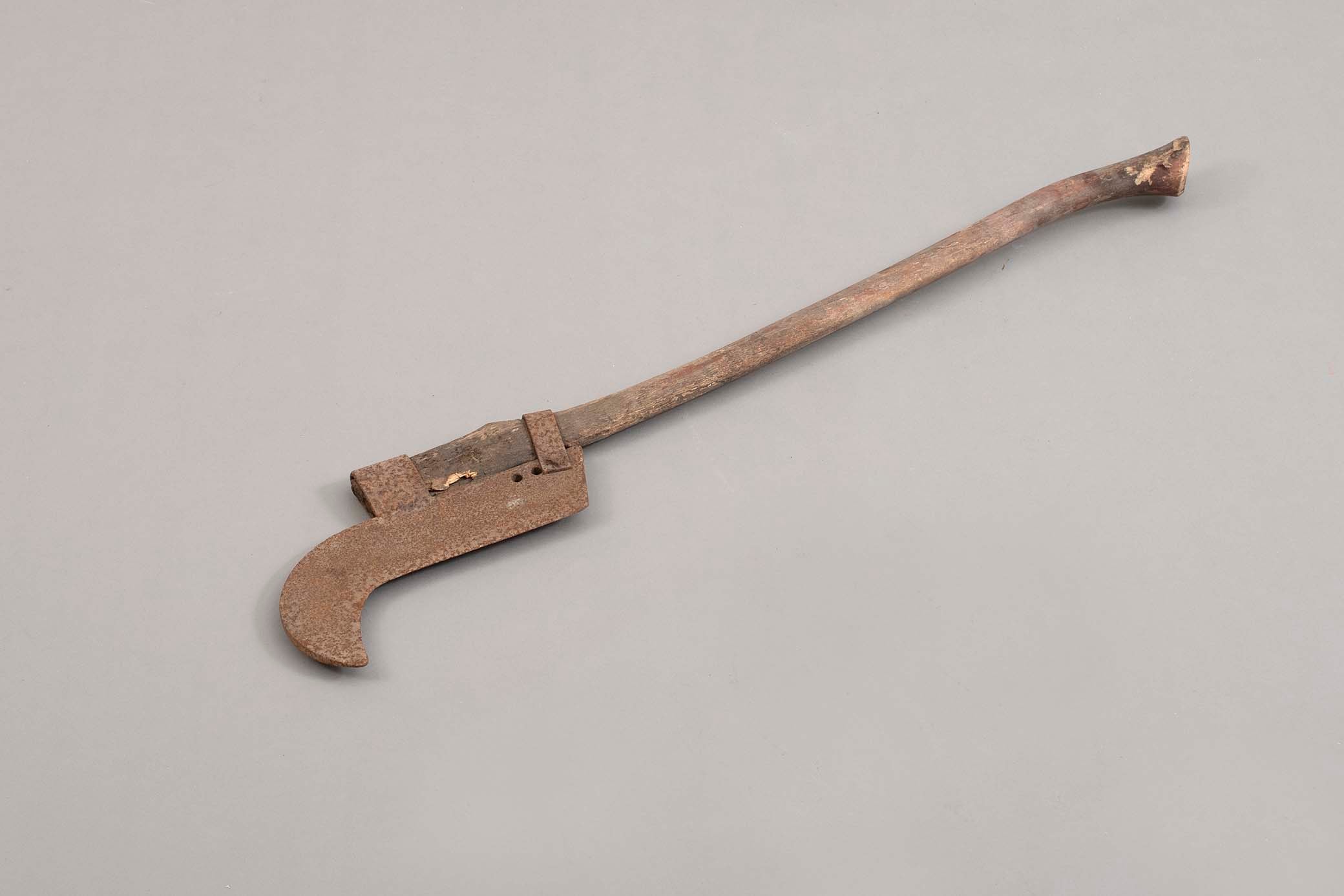
brush hook
https://search.heritageburnaby.ca/link/museumartifact91750
- Repository
- Burnaby Village Museum
- Accession Code
- BV023.14.6
- Description
- Tool with a hooked blade attached to a long wooden handle used for land clearing - cut heavy brush, shrubs, or small trees.
- The blade is made of iron and is heavily rusted. The handle is damaged in several spots and cracked where the blade is attached.
- Object History
- These items belonged to the Hong family - who founded Hop On Farms in Burnaby. Heritage Burnaby has a number of photos and an oral history about the family.
- Classification
- Maintenance T&E - - Groundskeeping Equipment
- Object Term
- Hook, Brush
- Measurements
- Length: 92 cm
- Subjects
- Persons - Chinese Canadians
- Agricultural Tools and Equipment
- Gardens
- Gardens - Market Gardens
- Names
- Hop on Farms
Images
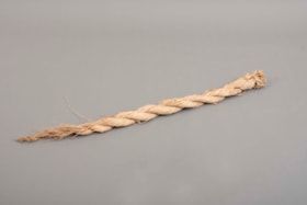
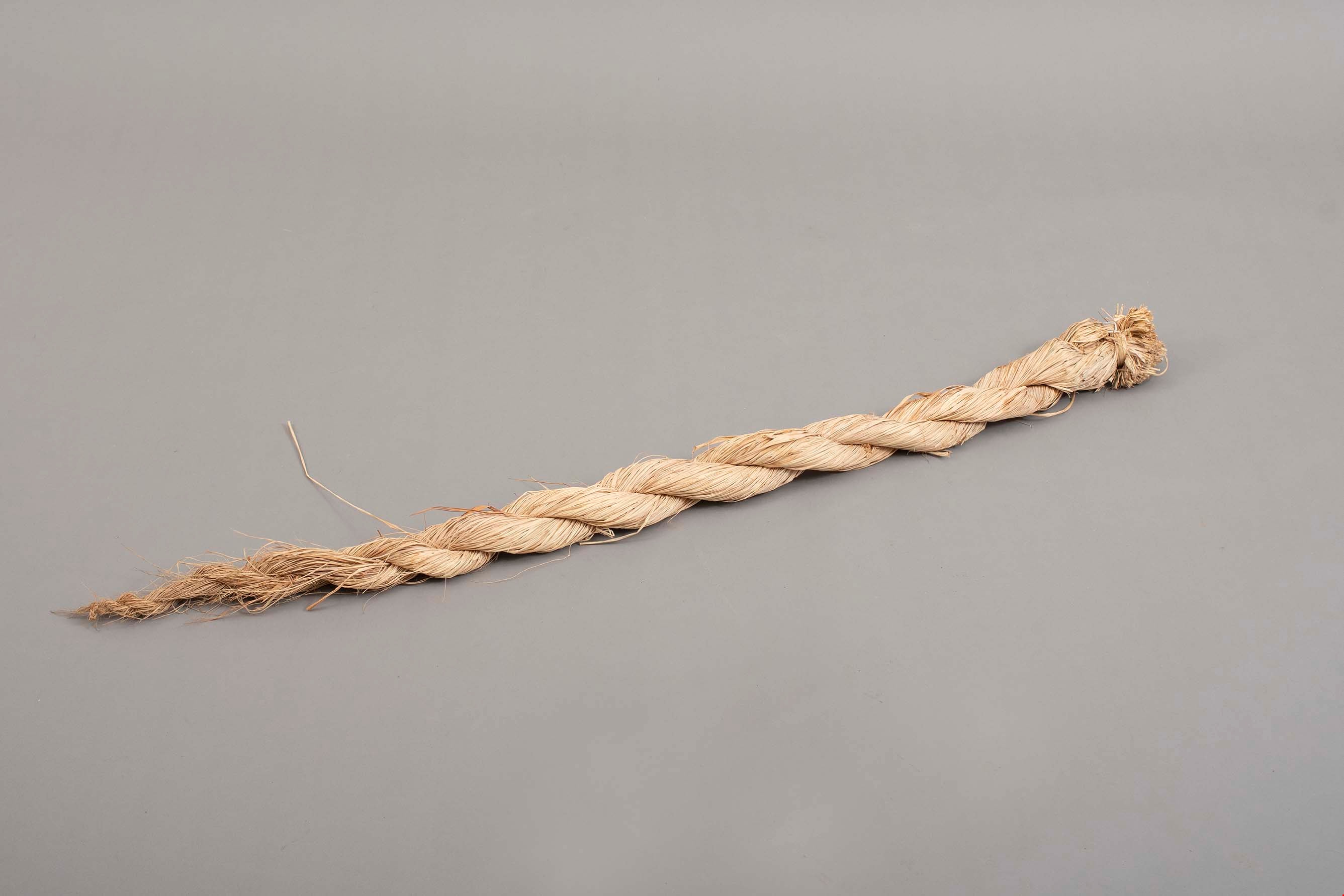
raffia bundle
https://search.heritageburnaby.ca/link/museumartifact91753
- Repository
- Burnaby Village Museum
- Accession Code
- BV023.14.9
- Description
- Bundle of raffia strands twisted into a bundle. The bundle is held together at the top by a strip of raffia and is knotted around itself at the bottom.
- Object History
- These items belonged to the Hong family - who founded Hop On Farms in Burnaby. Heritage Burnaby has a number of photos and an oral history about the family.
- Raffia bundle, used for tying vegetables in the fields. *We have a photo of raffia ties in use at Hop On Farm: BV017.36.7
- Measurements
- Length: 138 cm
- Subjects
- Persons - Chinese Canadians
- Agricultural Tools and Equipment
- Gardens
- Gardens - Market Gardens
- Names
- Hop on Farms
Images
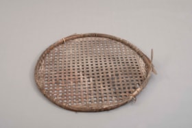
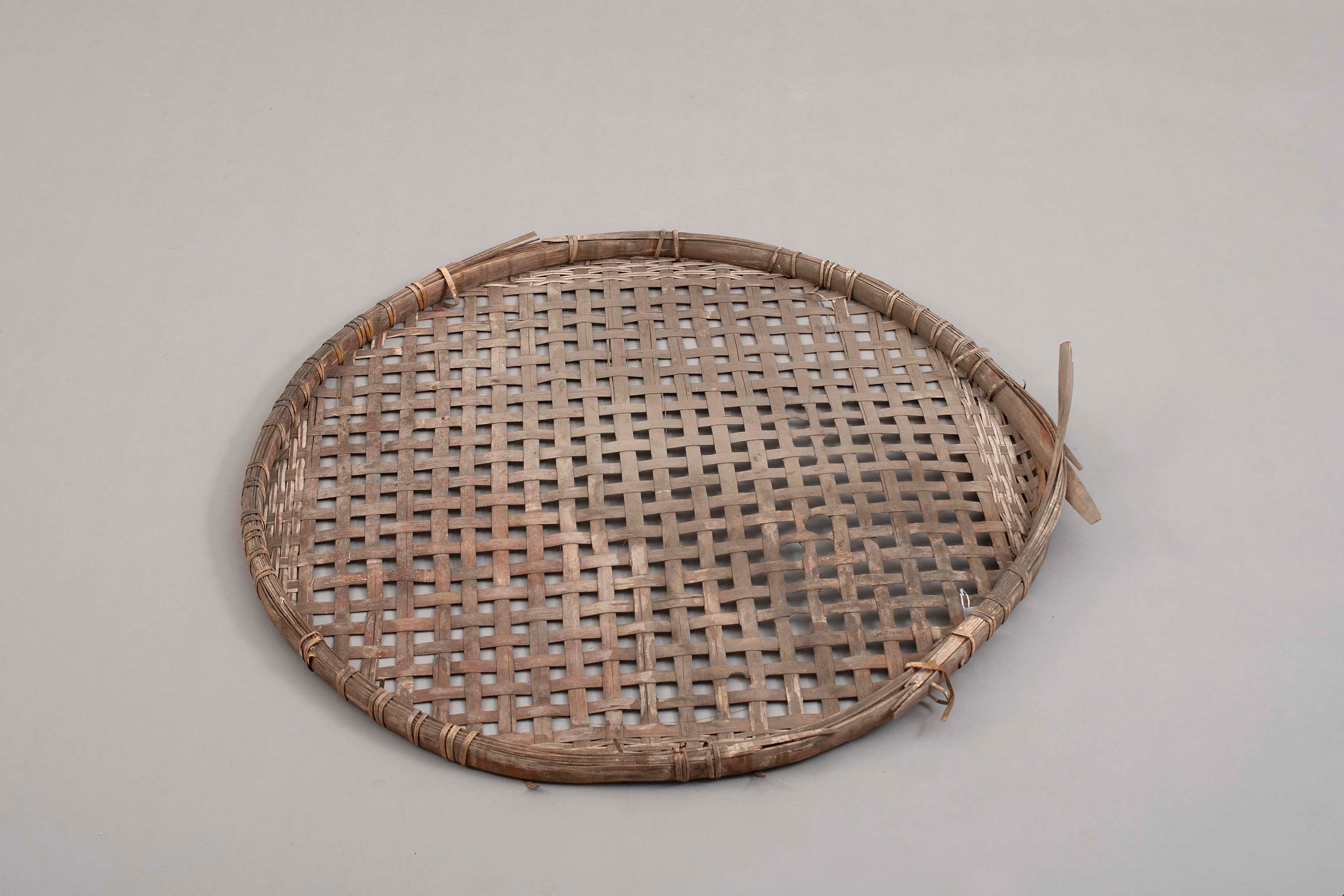
seed drying tray
https://search.heritageburnaby.ca/link/museumartifact91757
- Repository
- Burnaby Village Museum
- Accession Code
- BV023.14.12
- Description
- Large wooden hoop frame with thin slats of wood woven across it. This creates a shallow tray on one side of the hoop. The hoop is held together by ties around the hoop itself. Some of the ties have broken causing the hoop to come apart.
- The hoop and weave are very brittle.
- Object History
- These items belonged to the Hong family - who founded Hop On Farms in Burnaby. Heritage Burnaby has a number of photos and an oral history about the family.
- Seed drying tray, used when the family saved their own seed. They saved their seed to have a reliable supply of vegetable seeds difficult to find through the 1970s, 1980s and 1990s: choi sum, gai lan, bok choi. The seed heads were clipped and placed on the tray, and stored in the greenhouses to dry down. A finer sieve would have been used to separate the seeds from the chaff.
- Category
- 04.Tools & Equipment for Materials
- Classification
- Agricultural T&E
- Measurements
- Diameter: 86 cm
- Subjects
- Persons - Chinese Canadians
- Agricultural Tools and Equipment
- Gardens
- Gardens - Market Gardens
- Names
- Hop on Farms
Images

Crossing Royal Oak & Rumble Street
https://search.heritageburnaby.ca/link/archivedescription93686
- Repository
- City of Burnaby Archives
- Date
- May 19, 1978
- Collection/Fonds
- Burnaby Public Library Contemporary Visual Archive Project
- Description Level
- Item
- Physical Description
- 1 photograph : b&w ; 12.5 x 17.5 cm
- Scope and Content
- Photograph of the intersection of Royal Oak Avenue and Rumble Street. Cars and pedestrians are crossing the intersection, and the signs for businesses TD Bank, Standard Oil/Chevron gas station, Gulf gas station, and Baxter's Market are visible. The photograph is taken from a corner of the intersect…
- Repository
- City of Burnaby Archives
- Date
- May 19, 1978
- Collection/Fonds
- Burnaby Public Library Contemporary Visual Archive Project
- Physical Description
- 1 photograph : b&w ; 12.5 x 17.5 cm
- Description Level
- Item
- Record No.
- 556-643
- Access Restriction
- No restrictions
- Reproduction Restriction
- Reproduce for fair dealing purposes only
- Accession Number
- 2017-57
- Scope and Content
- Photograph of the intersection of Royal Oak Avenue and Rumble Street. Cars and pedestrians are crossing the intersection, and the signs for businesses TD Bank, Standard Oil/Chevron gas station, Gulf gas station, and Baxter's Market are visible. The photograph is taken from a corner of the intersection, facing southeast.
- Subjects
- Geographic Features - Roads
- Advertising Medium - Signs and Signboards
- Buildings - Commercial - Service Stations
- Transportation - Automobiles
- Buildings - Commercial
- Media Type
- Photograph
- Photographer
- van Mannen, Mark
- Notes
- Title taken from project information form
- Accompanied by a project information form and 1 photograph (b&w negative ; 9.5 x 12.5 cm)
- BPL no. 91
- Geographic Access
- Royal Oak Avenue
- Rumble Street
- Historic Neighbourhood
- Alta Vista (Historic Neighbourhood)
- Planning Study Area
- Sussex-Nelson Area
Images


Crossing Royal Oak & Rumble Street
https://search.heritageburnaby.ca/link/archivedescription93687
- Repository
- City of Burnaby Archives
- Date
- May 19, 1978
- Collection/Fonds
- Burnaby Public Library Contemporary Visual Archive Project
- Description Level
- Item
- Physical Description
- 1 photograph : b&w ; 12.5 x 17.5 cm
- Scope and Content
- Photograph of the intersection of Royal Oak Avenue and Rumble Street. Cars and pedestrians are crossing the intersection, and the signs for businesses Grace United Pharmacy, Standard Oil/Chevron gas station, Gulf gas station, and Royal Meats are visible. The photograph is taken from the Gulf gas st…
- Repository
- City of Burnaby Archives
- Date
- May 19, 1978
- Collection/Fonds
- Burnaby Public Library Contemporary Visual Archive Project
- Physical Description
- 1 photograph : b&w ; 12.5 x 17.5 cm
- Description Level
- Item
- Record No.
- 556-644
- Access Restriction
- No restrictions
- Reproduction Restriction
- Reproduce for fair dealing purposes only
- Accession Number
- 2017-57
- Scope and Content
- Photograph of the intersection of Royal Oak Avenue and Rumble Street. Cars and pedestrians are crossing the intersection, and the signs for businesses Grace United Pharmacy, Standard Oil/Chevron gas station, Gulf gas station, and Royal Meats are visible. The photograph is taken from the Gulf gas station parking lot, facing northwest.
- Subjects
- Advertising Medium - Signs and Signboards
- Geographic Features - Roads
- Transportation - Automobiles
- Buildings - Commercial
- Buildings - Commercial - Service Stations
- Media Type
- Photograph
- Photographer
- van Mannen, Mark
- Notes
- Title taken from project information form
- Accompanied by a project information form and 1 photograph (b&w negative ; 9.5 x 12.5 cm)
- BPL no. 92
- Geographic Access
- Royal Oak Avenue
- Rumble Street
- Historic Neighbourhood
- Alta Vista (Historic Neighbourhood)
- Planning Study Area
- Sussex-Nelson Area
Images


Central Park testing station
https://search.heritageburnaby.ca/link/archivedescription95101
- Repository
- City of Burnaby Archives
- Date
- May 9, 2020
- Collection/Fonds
- Burnaby Photographic Society fonds
- Description Level
- Item
- Physical Description
- 1 photograph (tiff)
- Scope and Content
- Photograph of the COVID-19 testing station located in the Central Park parking lot off Boundary Road. A sign in the foreground reads "Covid-19 Care Site by Referral Only / Walk in Access". In the background, the white tents of the testing station are visible.
- Repository
- City of Burnaby Archives
- Date
- May 9, 2020
- Collection/Fonds
- Burnaby Photographic Society fonds
- Physical Description
- 1 photograph (tiff)
- Description Level
- Item
- Record No.
- 623-019
- Access Restriction
- No restrictions
- Reproduction Restriction
- No restrictions
- Accession Number
- 2020-10
- Scope and Content
- Photograph of the COVID-19 testing station located in the Central Park parking lot off Boundary Road. A sign in the foreground reads "Covid-19 Care Site by Referral Only / Walk in Access". In the background, the white tents of the testing station are visible.
- Subjects
- Geographic Features - Parks
- Geographic Features - Automobile Parking Lots
- Advertising Medium - Signs and Signboards
- Structures - Tents
- Media Type
- Photograph
- Photographer
- Damer, Eric
- Notes
- Transcribed title
- Geographic Access
- Boundary Road
- Central Park
- Historic Neighbourhood
- Central Park (Historic Neighbourhood)
- Planning Study Area
- Maywood Area
Images


Deer Lake
https://search.heritageburnaby.ca/link/archivedescription91707
- Repository
- City of Burnaby Archives
- Date
- 1994-1996
- Collection/Fonds
- Doreen Lawson fonds
- Description Level
- File
- Physical Description
- 55 photographs : col. slides ; 35 mm
- Scope and Content
- File consists of scenic photographs of Deer Lake and Deer Lake Park, including closeup photographs of the lake and landscape photographs with the lake in the foreground and mountains and skyline visible in the distance. The photographs capture Deer Lake in the fall, winter, and spring. Also inclu…
- Repository
- City of Burnaby Archives
- Date
- 1994-1996
- Collection/Fonds
- Doreen Lawson fonds
- Physical Description
- 55 photographs : col. slides ; 35 mm
- Description Level
- File
- Record No.
- 618-025
- Access Restriction
- No restrictions
- Reproduction Restriction
- No restrictions
- Accession Number
- 2015-15
- Scope and Content
- File consists of scenic photographs of Deer Lake and Deer Lake Park, including closeup photographs of the lake and landscape photographs with the lake in the foreground and mountains and skyline visible in the distance. The photographs capture Deer Lake in the fall, winter, and spring. Also included in the file are four photographs of Deer Lake Park signs.
- Subjects
- Natural Phenomena - Snow
- Geographic Features - Lakes and Ponds
- Plants - Trees
- Geographic Features - Mountains
- Advertising Medium - Signs and Signboards
- Names
- Burnaby Art Gallery
- Media Type
- Photograph
- Photographer
- Lawson, Doreen A.
- Notes
- Title based on contents of photographs
- Geographic Access
- Deer Lake
- Historic Neighbourhood
- Burnaby Lake (Historic Neighbourhood)
- Planning Study Area
- Oakalla Area
Images

![Granville Street, Vancouver, [1910] thumbnail](/media/hpo/_Data/_BVM_Images/1972/1972_0050_0008_001.jpg?width=280)
Granville Street, Vancouver
https://search.heritageburnaby.ca/link/museumdescription1069
- Repository
- Burnaby Village Museum
- Date
- [1910]
- Collection/Fonds
- Burnaby Village Museum Photograph collection
- Description Level
- Item
- Physical Description
- 1 photograph : b&w ; 7.4 x 9.8 cm
- Scope and Content
- Photograph of Granville Street, looking north. Signs for "Fletchers Pianos" and the "Colonial Theatre" can be seen. The north shore is faintly visible across Burrard Inlet.
- Repository
- Burnaby Village Museum
- Collection/Fonds
- Burnaby Village Museum Photograph collection
- Description Level
- Item
- Physical Description
- 1 photograph : b&w ; 7.4 x 9.8 cm
- Scope and Content
- Photograph of Granville Street, looking north. Signs for "Fletchers Pianos" and the "Colonial Theatre" can be seen. The north shore is faintly visible across Burrard Inlet.
- Subjects
- Advertising Medium - Signs and Signboards
- Buildings - Commercial
- Geographic Features - Roads
- Geographic Access
- Vancouver
- Accession Code
- HV972.50.8
- Access Restriction
- No restrictions
- Reproduction Restriction
- No known restrictions
- Date
- [1910]
- Media Type
- Photograph
- Scan Resolution
- 600
- Scan Date
- 2023-04-04
- Photographer
- Dean, H.M.
- Notes
- Title based on contents of photograph
- An annotation on the back of the photograph reads, "Granville St. - 1910."
Images
![Granville Street, Vancouver, [1910] thumbnail](/media/hpo/_Data/_BVM_Images/1972/1972_0050_0008_001.jpg)

Reconstructed Central Park Band Stand
https://search.heritageburnaby.ca/link/archivedescription95123
- Repository
- City of Burnaby Archives
- Date
- May 28, 2020
- Collection/Fonds
- Burnaby Photographic Society fonds
- Description Level
- Item
- Physical Description
- 1 photograph (tiff)
- Scope and Content
- Photograph of the band stand in Central Park. The band stand stairs are blocked off with orange netting and a City of Burnaby facility closure sign.
- Repository
- City of Burnaby Archives
- Date
- May 28, 2020
- Collection/Fonds
- Burnaby Photographic Society fonds
- Physical Description
- 1 photograph (tiff)
- Description Level
- Item
- Record No.
- 623-041
- Access Restriction
- No restrictions
- Reproduction Restriction
- No restrictions
- Accession Number
- 2020-10
- Scope and Content
- Photograph of the band stand in Central Park. The band stand stairs are blocked off with orange netting and a City of Burnaby facility closure sign.
- Subjects
- Buildings - Recreational - Bandstands
- Geographic Features - Parks
- Advertising Medium - Signs and Signboards
- Media Type
- Photograph
- Photographer
- Cheung, Ray
- Notes
- Transcribed title
- Geographic Access
- Central Park
- Imperial Street
- Street Address
- 3883 Imperial Street
- Historic Neighbourhood
- Central Park (Historic Neighbourhood)
- Planning Study Area
- Maywood Area
Images

![Burnaby General Hospital, [1977] thumbnail](/media/hpo/_Data/_Archives_Images/_Unrestricted/480/480-227.jpg?width=280)
Burnaby General Hospital
https://search.heritageburnaby.ca/link/archivedescription45332
- Repository
- City of Burnaby Archives
- Date
- [1977]
- Collection/Fonds
- Columbian Newspaper collection
- Description Level
- Item
- Physical Description
- 1 photograph : b&w ; 15.5 x 24.5 cm
- Scope and Content
- Photograph of a large directional sign for the Burnaby General Hospital, with an ambulance parked in the background, just in front of the hospital.
- Repository
- City of Burnaby Archives
- Date
- [1977]
- Collection/Fonds
- Columbian Newspaper collection
- Physical Description
- 1 photograph : b&w ; 15.5 x 24.5 cm
- Description Level
- Item
- Record No.
- 480-227
- Access Restriction
- No restrictions
- Reproduction Restriction
- Reproduce for fair dealing purposes only
- Accession Number
- 2003-02
- Scope and Content
- Photograph of a large directional sign for the Burnaby General Hospital, with an ambulance parked in the background, just in front of the hospital.
- Subjects
- Buildings - Civic - Hospitals
- Advertising Medium - Signs and Signboards
- Transportation - Ambulances
- Names
- Burnaby General Hospital
- Media Type
- Photograph
- Notes
- Title based on contents of photograph
- Geographic Access
- Kincaid Street
- Street Address
- 3935 Kincaid Street
- Historic Neighbourhood
- Broadview (Historic Neighbourhood)
- Planning Study Area
- Cascade-Schou Area
Images
![Burnaby General Hospital, [1977] thumbnail](/media/hpo/_Data/_Archives_Images/_Unrestricted/480/480-227.jpg)
2761 North Rd
https://search.heritageburnaby.ca/link/archivedescription94334
- Repository
- City of Burnaby Archives
- Date
- April 1995
- Collection/Fonds
- Grover, Elliott & Co. Ltd. fonds
- Description Level
- File
- Physical Description
- 24 photographs : col. negatives ; 35 mm
- Scope and Content
- Photographs of an undeveloped property located at 2761 North Road - an address that no longer exists. Three large billboards are posted at the edge of the property, facing onto the street.
- Repository
- City of Burnaby Archives
- Date
- April 1995
- Collection/Fonds
- Grover, Elliott & Co. Ltd. fonds
- Physical Description
- 24 photographs : col. negatives ; 35 mm
- Description Level
- File
- Record No.
- 622-119
- Access Restriction
- No restrictions
- Reproduction Restriction
- No restrictions
- Accession Number
- 2017-39
- Scope and Content
- Photographs of an undeveloped property located at 2761 North Road - an address that no longer exists. Three large billboards are posted at the edge of the property, facing onto the street.
- Media Type
- Photograph
- Photographer
- Young, Richard
- Notes
- Transcribed title
- Title transcribed from envelope photographs were originally housed in
- File no. 95-167-B
- Geographic Access
- North Road
- Historic Neighbourhood
- Burquitlam (Historic Neighbourhood)
- Planning Study Area
- Lyndhurst Area
4250 Grange St
https://search.heritageburnaby.ca/link/archivedescription93892
- Repository
- City of Burnaby Archives
- Date
- June 1993
- Collection/Fonds
- Grover, Elliott & Co. Ltd. fonds
- Description Level
- File
- Physical Description
- 25 photographs : col. negatives ; 35 mm
- Scope and Content
- Photographs of an undeveloped property located at 4250 Grange Street - an address that no longer exists. The property's current address is 5833 Wilson Avenue. A billboard in front of the property reads: Paramount / Coming Soon / Two 21-Storey Luxury Twin Towers".
- Repository
- City of Burnaby Archives
- Date
- June 1993
- Collection/Fonds
- Grover, Elliott & Co. Ltd. fonds
- Physical Description
- 25 photographs : col. negatives ; 35 mm
- Description Level
- File
- Record No.
- 622-075
- Access Restriction
- No restrictions
- Reproduction Restriction
- No restrictions
- Accession Number
- 2017-39
- Scope and Content
- Photographs of an undeveloped property located at 4250 Grange Street - an address that no longer exists. The property's current address is 5833 Wilson Avenue. A billboard in front of the property reads: Paramount / Coming Soon / Two 21-Storey Luxury Twin Towers".
- Media Type
- Photograph
- Notes
- Transcribed title
- Title transcribed from envelope photographs were originally housed in
- File no. 93-284-B
- Photographer identified as "J.C."
- Geographic Access
- Wilson Avenue
- Grange Street
- Street Address
- 5833 Wilson Avenue
- Historic Neighbourhood
- Central Park (Historic Neighbourhood)
- Planning Study Area
- Garden Village Area

Burnaby's COVID-19 drive thru testing site
https://search.heritageburnaby.ca/link/museumdescription15374
- Repository
- Burnaby Village Museum
- Date
- 5 Apr. 2020
- Collection/Fonds
- Burnaby Village Museum COVID-19 collection
- Description Level
- Item
- Physical Description
- 1 photograph (jpg)
- Scope and Content
- Photograph of the COVID-19 drive thru testing site in Central Park parking lot in Burnaby. Orange traffic posts and wayfinding signs are set up in the parking lot.
- Repository
- Burnaby Village Museum
- Collection/Fonds
- Burnaby Village Museum COVID-19 collection
- Description Level
- Item
- Physical Description
- 1 photograph (jpg)
- Scope and Content
- Photograph of the COVID-19 drive thru testing site in Central Park parking lot in Burnaby. Orange traffic posts and wayfinding signs are set up in the parking lot.
- Subjects
- Advertising Medium - Signs and Signboards
- Geographic Features - Parks
- Public Services - Health Services
- Pandemics - COVID-19
- Geographic Access
- Central Park
- Imperial Street
- Accession Code
- BV021.2.39
- Access Restriction
- No restrictions
- Reproduction Restriction
- May be restricted by third party rights
- Date
- 5 Apr. 2020
- Media Type
- Photograph
- Historic Neighbourhood
- Central Park (Historic Neighbourhood)
- Planning Study Area
- Maywood Area
- Notes
- Title based on contents of photograph
Images


Burnaby's COVID-19 drive thru testing site
https://search.heritageburnaby.ca/link/museumdescription15375
- Repository
- Burnaby Village Museum
- Date
- 5 Apr. 2020
- Collection/Fonds
- Burnaby Village Museum COVID-19 collection
- Description Level
- Item
- Physical Description
- 1 photograph (jpg)
- Scope and Content
- Photograph of the COVID-19 drive thru testing site in Central Park parking lot in Burnaby. Orange traffic posts, wayfinding signs and white tents are set up in the parking lot.
- Repository
- Burnaby Village Museum
- Collection/Fonds
- Burnaby Village Museum COVID-19 collection
- Description Level
- Item
- Physical Description
- 1 photograph (jpg)
- Scope and Content
- Photograph of the COVID-19 drive thru testing site in Central Park parking lot in Burnaby. Orange traffic posts, wayfinding signs and white tents are set up in the parking lot.
- Subjects
- Advertising Medium - Signs and Signboards
- Geographic Features - Parks
- Public Services - Health Services
- Pandemics - COVID-19
- Geographic Access
- Central Park
- Imperial Street
- Accession Code
- BV021.2.40
- Access Restriction
- No restrictions
- Reproduction Restriction
- May be restricted by third party rights
- Date
- 5 Apr. 2020
- Media Type
- Photograph
- Historic Neighbourhood
- Central Park (Historic Neighbourhood)
- Planning Study Area
- Maywood Area
- Notes
- Title based on contents of photograph
Images


Burnaby's COVID-19 drive thru testing site
https://search.heritageburnaby.ca/link/museumdescription15376
- Repository
- Burnaby Village Museum
- Date
- 5 Apr. 2020
- Collection/Fonds
- Burnaby Village Museum COVID-19 collection
- Description Level
- Item
- Physical Description
- 1 photograph (jpg)
- Scope and Content
- Photograph of the COVID-19 drive thru testing site in Central Park parking lot in Burnaby. Orange traffic posts, wayfinding signs and white tents are set up in the parking lot.
- Repository
- Burnaby Village Museum
- Collection/Fonds
- Burnaby Village Museum COVID-19 collection
- Description Level
- Item
- Physical Description
- 1 photograph (jpg)
- Scope and Content
- Photograph of the COVID-19 drive thru testing site in Central Park parking lot in Burnaby. Orange traffic posts, wayfinding signs and white tents are set up in the parking lot.
- Subjects
- Advertising Medium - Signs and Signboards
- Geographic Features - Parks
- Public Services - Health Services
- Pandemics - COVID-19
- Geographic Access
- Central Park
- Imperial Street
- Accession Code
- BV021.2.41
- Access Restriction
- No restrictions
- Reproduction Restriction
- May be restricted by third party rights
- Date
- 5 Apr. 2020
- Media Type
- Photograph
- Historic Neighbourhood
- Central Park (Historic Neighbourhood)
- Planning Study Area
- Maywood Area
- Notes
- Title based on contents of photograph
Images


Burnaby's COVID-19 drive thru testing site
https://search.heritageburnaby.ca/link/museumdescription15377
- Repository
- Burnaby Village Museum
- Date
- 5 Apr. 2020
- Collection/Fonds
- Burnaby Village Museum COVID-19 collection
- Description Level
- Item
- Physical Description
- 1 photograph (jpg)
- Scope and Content
- Photograph of the COVID-19 drive thru testing site in Central Park parking lot in Burnaby. Orange traffic posts, wayfinding signs and white tents are set up in the parking lot.
- Repository
- Burnaby Village Museum
- Collection/Fonds
- Burnaby Village Museum COVID-19 collection
- Description Level
- Item
- Physical Description
- 1 photograph (jpg)
- Scope and Content
- Photograph of the COVID-19 drive thru testing site in Central Park parking lot in Burnaby. Orange traffic posts, wayfinding signs and white tents are set up in the parking lot.
- Subjects
- Advertising Medium - Signs and Signboards
- Geographic Features - Parks
- Public Services - Health Services
- Pandemics - COVID-19
- Geographic Access
- Central Park
- Imperial Street
- Accession Code
- BV021.2.42
- Access Restriction
- No restrictions
- Reproduction Restriction
- May be restricted by third party rights
- Date
- 5 Apr. 2020
- Media Type
- Photograph
- Historic Neighbourhood
- Central Park (Historic Neighbourhood)
- Planning Study Area
- Maywood Area
- Notes
- Title based on contents of photograph
Images
