More like 'Delnor Frozen Foods'
Narrow Results By
Subject
- Accidents - Automobile Accidents 1
- Advertising Medium 3
- Advertising Medium - Signs and Signboards 81
- Aerial Photographs 26
- Agricultural Tools and Equipment - Plows 3
- Agriculture 2
- Agriculture - Crops 2
- Agriculture - Farms 48
- Agriculture - Fruit and Berries 5
- Agriculture - Poultry 4
- Animals - Birds 2
- Animals - Cats 5
![Spear and Jackson Saws Ltd., [1958] thumbnail](/media/hpo/_Data/_Archives_Images/_Unrestricted/001/102-002.jpg?width=280)
Spear and Jackson Saws Ltd.
https://search.heritageburnaby.ca/link/archivedescription34697
- Repository
- City of Burnaby Archives
- Date
- [1958]
- Collection/Fonds
- Burnaby Historical Society fonds
- Description Level
- Item
- Physical Description
- 1 photograph : b&w ; 20.6 x 25.3 cm
- Scope and Content
- Photograph of the interior of a Spear and Jackson (B.C.) Ltd. saw manufacturers building. Machinery can be seen.
- Repository
- City of Burnaby Archives
- Date
- [1958]
- Collection/Fonds
- Burnaby Historical Society fonds
- Subseries
- Photographs subseries
- Physical Description
- 1 photograph : b&w ; 20.6 x 25.3 cm
- Description Level
- Item
- Record No.
- 102-002
- Access Restriction
- No restrictions
- Reproduction Restriction
- Reproduce for fair dealing purposes only
- Accession Number
- BHS2007-04
- Scope and Content
- Photograph of the interior of a Spear and Jackson (B.C.) Ltd. saw manufacturers building. Machinery can be seen.
- Subjects
- Buildings - Industrial - Factories
- Media Type
- Photograph
- Notes
- Title based on contents of photograph
Images
![Spear and Jackson Saws Ltd., [1958] thumbnail](/media/hpo/_Data/_Archives_Images/_Unrestricted/001/102-002.jpg)
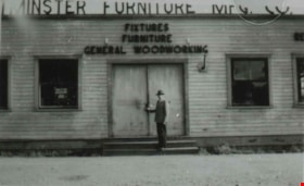
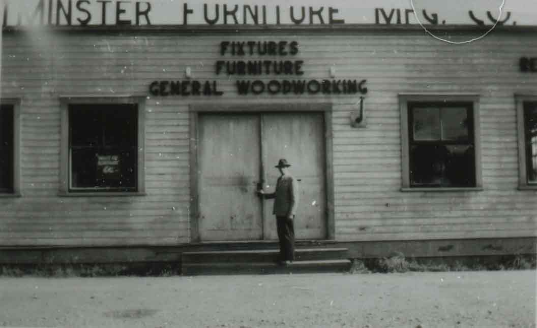
Woodworking Business on Edmonds Street
https://search.heritageburnaby.ca/link/archivedescription37826
- Repository
- City of Burnaby Archives
- Date
- 1944 (date of original), copied 1991
- Collection/Fonds
- Burnaby Historical Society fonds
- Description Level
- Item
- Physical Description
- 1 photograph : b&w ; 2.7 x 4.5 cm print on contact sheet 20.6 x 26.2 cm
- Scope and Content
- Photograph of a furniture and woodworking business, Westminster Furniture Manufacturing Company at 1470 Edmonds Street (later renumbered as the 7200 block of Edmonds Street). Signs above the door read, "Fixtures, Furniture, General Woodworking," and a man is standing outside.
- Repository
- City of Burnaby Archives
- Date
- 1944 (date of original), copied 1991
- Collection/Fonds
- Burnaby Historical Society fonds
- Subseries
- Burnaby Image Bank subseries
- Physical Description
- 1 photograph : b&w ; 2.7 x 4.5 cm print on contact sheet 20.6 x 26.2 cm
- Description Level
- Item
- Record No.
- 370-414
- Access Restriction
- No restrictions
- Reproduction Restriction
- No known restrictions
- Accession Number
- BHS1999-03
- Scope and Content
- Photograph of a furniture and woodworking business, Westminster Furniture Manufacturing Company at 1470 Edmonds Street (later renumbered as the 7200 block of Edmonds Street). Signs above the door read, "Fixtures, Furniture, General Woodworking," and a man is standing outside.
- Media Type
- Photograph
- Notes
- Title based on contents of photograph
- 1 b&w copy negative accompanying
- Negative has a pink cast
- Geographic Access
- Edmonds Street
- Historic Neighbourhood
- Edmonds (Historic Neighbourhood)
- Planning Study Area
- Stride Avenue Area
Images

Woodworking Plant
https://search.heritageburnaby.ca/link/archivedescription35247
- Repository
- City of Burnaby Archives
- Date
- 1954 (date of original), copied 1986
- Collection/Fonds
- Burnaby Historical Society fonds
- Description Level
- Item
- Physical Description
- 1 photograph : b&w ; 12.7 x 17.8 cm print
- Scope and Content
- Photograph of James Brookes Woodworking Plant, located at 7730 6th Street, taken from 6th Avenue after a heavy snowfall. The plant was built originally as Cliff's Can Factory, and also served as Western Canadian Can Factory.
- Repository
- City of Burnaby Archives
- Date
- 1954 (date of original), copied 1986
- Collection/Fonds
- Burnaby Historical Society fonds
- Subseries
- Pioneer Tales subseries
- Physical Description
- 1 photograph : b&w ; 12.7 x 17.8 cm print
- Description Level
- Item
- Record No.
- 204-104
- Access Restriction
- No restrictions
- Reproduction Restriction
- Reproduce for fair dealing purposes only
- Accession Number
- BHS1988-03
- Scope and Content
- Photograph of James Brookes Woodworking Plant, located at 7730 6th Street, taken from 6th Avenue after a heavy snowfall. The plant was built originally as Cliff's Can Factory, and also served as Western Canadian Can Factory.
- Media Type
- Photograph
- Notes
- Title based on contents of photograph
- Geographic Access
- 6th Street
- Street Address
- 7730 6th Street
- Historic Neighbourhood
- East Burnaby (Historic Neighbourhood)
- Planning Study Area
- Second Street Area
Images

![Woodworking Plant, [192-] (date of original), copied 1986 thumbnail](/media/hpo/_Data/_Archives_Images/_Unrestricted/204/204-106.jpg?width=280)
Woodworking Plant
https://search.heritageburnaby.ca/link/archivedescription35249
- Repository
- City of Burnaby Archives
- Date
- [192-] (date of original), copied 1986
- Collection/Fonds
- Burnaby Historical Society fonds
- Description Level
- Item
- Physical Description
- 1 photograph : b&w ; 12.7 x 17.8 cm print
- Scope and Content
- Photograph of James Brookes Woodworking Plant located at 7730 6th Street. This site has also served as Cliff's Can Factory and Western Canadian Can Factory. Note the spur street car line (no. 2) where B.C. Electric Railway freight cars could load and unload.
- Repository
- City of Burnaby Archives
- Date
- [192-] (date of original), copied 1986
- Collection/Fonds
- Burnaby Historical Society fonds
- Subseries
- Pioneer Tales subseries
- Physical Description
- 1 photograph : b&w ; 12.7 x 17.8 cm print
- Description Level
- Item
- Record No.
- 204-106
- Access Restriction
- No restrictions
- Reproduction Restriction
- No known restrictions
- Accession Number
- BHS1988-03
- Scope and Content
- Photograph of James Brookes Woodworking Plant located at 7730 6th Street. This site has also served as Cliff's Can Factory and Western Canadian Can Factory. Note the spur street car line (no. 2) where B.C. Electric Railway freight cars could load and unload.
- Subjects
- Buildings - Industrial - Factories
- Media Type
- Photograph
- Notes
- Title based on contents of photograph
- Geographic Access
- 6th Street
- Street Address
- 7730 6th Street
- Historic Neighbourhood
- East Burnaby (Historic Neighbourhood)
- Planning Study Area
- Second Street Area
Images
![Woodworking Plant, [192-] (date of original), copied 1986 thumbnail](/media/hpo/_Data/_Archives_Images/_Unrestricted/204/204-106.jpg)
![Woodworking Plant, [192-] (date of original), copied 1986 thumbnail](/media/hpo/_Data/_Archives_Images/_Unrestricted/204/204-107.jpg?width=280)
Woodworking Plant
https://search.heritageburnaby.ca/link/archivedescription35250
- Repository
- City of Burnaby Archives
- Date
- [192-] (date of original), copied 1986
- Collection/Fonds
- Burnaby Historical Society fonds
- Description Level
- Item
- Physical Description
- 1 photograph : b&w ; 12.7 x 17.8 cm print
- Scope and Content
- Photograph of James Brookes Woodworking Plant, located at 7730 6th Street, taken from 13th Avenue. This site has also served as Cliff's Can Factory and Western Canadian Can Factory.
- Repository
- City of Burnaby Archives
- Date
- [192-] (date of original), copied 1986
- Collection/Fonds
- Burnaby Historical Society fonds
- Subseries
- Pioneer Tales subseries
- Physical Description
- 1 photograph : b&w ; 12.7 x 17.8 cm print
- Description Level
- Item
- Record No.
- 204-107
- Access Restriction
- No restrictions
- Reproduction Restriction
- No known restrictions
- Accession Number
- BHS1988-03
- Scope and Content
- Photograph of James Brookes Woodworking Plant, located at 7730 6th Street, taken from 13th Avenue. This site has also served as Cliff's Can Factory and Western Canadian Can Factory.
- Subjects
- Buildings - Industrial - Factories
- Media Type
- Photograph
- Notes
- Title based on contents of photograph
- Geographic Access
- 6th Street
- Street Address
- 7730 6th Street
- Historic Neighbourhood
- East Burnaby (Historic Neighbourhood)
- Planning Study Area
- Second Street Area
Images
![Woodworking Plant, [192-] (date of original), copied 1986 thumbnail](/media/hpo/_Data/_Archives_Images/_Unrestricted/204/204-107.jpg)
![Woodworking Plant, [192-] (date of original), copied 1986 thumbnail](/media/hpo/_Data/_Archives_Images/_Unrestricted/204/204-108.jpg?width=280)
Woodworking Plant
https://search.heritageburnaby.ca/link/archivedescription35251
- Repository
- City of Burnaby Archives
- Date
- [192-] (date of original), copied 1986
- Collection/Fonds
- Burnaby Historical Society fonds
- Description Level
- Item
- Physical Description
- 1 photograph : b&w ; 12.7 x 17.8 cm print
- Scope and Content
- Photograph of James Brookes Woodworking Plant, located at 7730 6th Street, taken from 6th Street. It was an East Burnaby landmark, established in 1902 as a can company by Edwin Cliff. This site has also served as Cliff's Can Factory and Western Canadian Can Factory.
- Repository
- City of Burnaby Archives
- Date
- [192-] (date of original), copied 1986
- Collection/Fonds
- Burnaby Historical Society fonds
- Subseries
- Pioneer Tales subseries
- Physical Description
- 1 photograph : b&w ; 12.7 x 17.8 cm print
- Description Level
- Item
- Record No.
- 204-108
- Access Restriction
- No restrictions
- Reproduction Restriction
- No known restrictions
- Accession Number
- BHS1988-03
- Scope and Content
- Photograph of James Brookes Woodworking Plant, located at 7730 6th Street, taken from 6th Street. It was an East Burnaby landmark, established in 1902 as a can company by Edwin Cliff. This site has also served as Cliff's Can Factory and Western Canadian Can Factory.
- Subjects
- Buildings - Industrial - Factories
- Media Type
- Photograph
- Notes
- Title based on contents of photograph
- Geographic Access
- 6th Street
- Street Address
- 7730 6th Street
- Historic Neighbourhood
- East Burnaby (Historic Neighbourhood)
- Planning Study Area
- Second Street Area
Images
![Woodworking Plant, [192-] (date of original), copied 1986 thumbnail](/media/hpo/_Data/_Archives_Images/_Unrestricted/204/204-108.jpg)
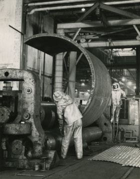
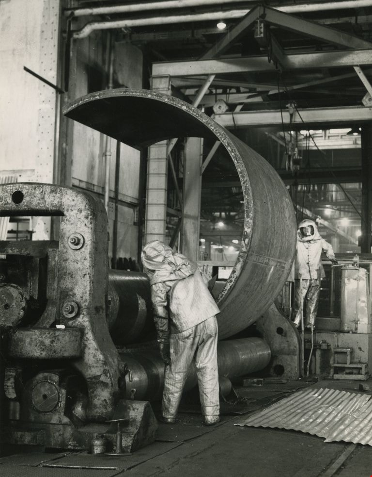
Working at the Dominion Bridge Co.'s Burnaby plant
https://search.heritageburnaby.ca/link/archivedescription45613
- Repository
- City of Burnaby Archives
- Date
- April 1966, published April 18, 1966
- Collection/Fonds
- Columbian Newspaper collection
- Description Level
- Item
- Physical Description
- 1 photograph : b&w ; 24 x 18.5 cm
- Scope and Content
- Photograph of workmen at the Dominion Bridge Co.'s Burnaby plant. They are feeding a flat steel plate, more than three inches think inot a pyramind roll for fabrication in the making of a sulfinol vessel for the petroleum industry in Alberta. The workmen are wearing asbestos aluminum suits to withs…
- Repository
- City of Burnaby Archives
- Date
- April 1966, published April 18, 1966
- Collection/Fonds
- Columbian Newspaper collection
- Physical Description
- 1 photograph : b&w ; 24 x 18.5 cm
- Description Level
- Item
- Record No.
- 480-507
- Access Restriction
- No restrictions
- Reproduction Restriction
- Reproduce for fair dealing purposes only
- Accession Number
- 2003-02
- Scope and Content
- Photograph of workmen at the Dominion Bridge Co.'s Burnaby plant. They are feeding a flat steel plate, more than three inches think inot a pyramind roll for fabrication in the making of a sulfinol vessel for the petroleum industry in Alberta. The workmen are wearing asbestos aluminum suits to withstand the intense heat reflected from the heated plate (the plate was heated in a furnace before being fed into the pyramid roll).
- Names
- Dominion Bridge Company
- Media Type
- Photograph
- Photographer
- Henry Tregillas Photography Ltd.
- Notes
- Title based on contents of photograph
- Geographic Access
- Boundary Road
- Street Address
- 2400 Boundary Road
- Historic Neighbourhood
- Broadview (Historic Neighbourhood)
- Planning Study Area
- West Central Valley Area
Images
Chevron Oil Refinery
https://search.heritageburnaby.ca/link/archivedescription79435
- Repository
- City of Burnaby Archives
- Date
- September 5, 1976
- Collection/Fonds
- Burnaby Public Library Contemporary Visual Archive Project
- Description Level
- Item
- Physical Description
- 1 photograph : b&w ; 11 x 16 cm mounted on cardboard
- Scope and Content
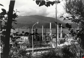
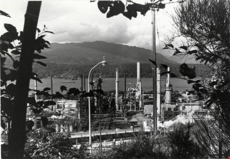
- Photograph shows an aerial view of the Chevron Oil Refinery at the north end of Willingdon Avenue with the North Shore in the background. The photo was taken from the top of Penzance Drive.
- Repository
- City of Burnaby Archives
- Date
- September 5, 1976
- Collection/Fonds
- Burnaby Public Library Contemporary Visual Archive Project
- Physical Description
- 1 photograph : b&w ; 11 x 16 cm mounted on cardboard
- Description Level
- Item
- Record No.
- 556-287
- Access Restriction
- No restrictions
- Reproduction Restriction
- Reproduce for fair dealing purposes only
- Accession Number
- 2013-13
- Scope and Content
- Photograph shows an aerial view of the Chevron Oil Refinery at the north end of Willingdon Avenue with the North Shore in the background. The photo was taken from the top of Penzance Drive.
- Names
- Chevron Corporation
- Media Type
- Photograph
- Notes
- Scope note taken directly from BPL photograph description.
- 1 b&w copy negative : 10 x 12.5 cm accompanying
- Photographers identified by surnames only: Carr and Vardeman
- Geographic Access
- Eton Street
- Street Address
- 4403 Eton Street
- Historic Neighbourhood
- Vancouver Heights (Historic Neighbourhood)
- Planning Study Area
- Burnaby Heights Area
Images
Chevron Oil Refinery
https://search.heritageburnaby.ca/link/archivedescription79436
- Repository
- City of Burnaby Archives
- Date
- September 12, 1976
- Collection/Fonds
- Burnaby Public Library Contemporary Visual Archive Project
- Description Level
- Item
- Physical Description
- 1 photograph : b&w ; 11 x 16 cm mounted on cardboard
- Scope and Content
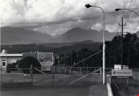
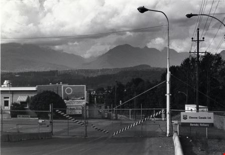
- Photograph shows the entrance gate to the Chevron Oil Refinery at the north end of Willingdon Avenue, with a view of the North Shore in the background.
- Repository
- City of Burnaby Archives
- Date
- September 12, 1976
- Collection/Fonds
- Burnaby Public Library Contemporary Visual Archive Project
- Physical Description
- 1 photograph : b&w ; 11 x 16 cm mounted on cardboard
- Description Level
- Item
- Record No.
- 556-288
- Access Restriction
- No restrictions
- Reproduction Restriction
- Reproduce for fair dealing purposes only
- Accession Number
- 2013-13
- Scope and Content
- Photograph shows the entrance gate to the Chevron Oil Refinery at the north end of Willingdon Avenue, with a view of the North Shore in the background.
- Names
- Chevron Corporation
- Media Type
- Photograph
- Notes
- Scope note taken directly from BPL photograph description.
- 1 b&w copy negative : 10 x 12.5 cm accompanying
- Photographers identified by surnames only: Carr and Vardeman
- Geographic Access
- Eton Street
- Street Address
- 4403 Eton Street
- Historic Neighbourhood
- Vancouver Heights (Historic Neighbourhood)
- Planning Study Area
- Burnaby Heights Area
Images

Gulf Oil Refinery
https://search.heritageburnaby.ca/link/archivedescription79437
- Repository
- City of Burnaby Archives
- Date
- September 12, 1976
- Collection/Fonds
- Burnaby Public Library Contemporary Visual Archive Project
- Description Level
- Item
- Physical Description
- 1 photograph : b&w ; 11 x 16 cm mounted on cardboard
- Scope and Content
- Photograph shows a truck coming out of the Gulf Oil Refinery on Barnet Road near the boundary of Burnaby and Coquitlam.
- Repository
- City of Burnaby Archives
- Date
- September 12, 1976
- Collection/Fonds
- Burnaby Public Library Contemporary Visual Archive Project
- Physical Description
- 1 photograph : b&w ; 11 x 16 cm mounted on cardboard
- Description Level
- Item
- Record No.
- 556-289
- Access Restriction
- No restrictions
- Reproduction Restriction
- Reproduce for fair dealing purposes only
- Accession Number
- 2013-13
- Scope and Content
- Photograph shows a truck coming out of the Gulf Oil Refinery on Barnet Road near the boundary of Burnaby and Coquitlam.
- Names
- Gulf Oil
- Media Type
- Photograph
- Notes
- Scope note taken directly from BPL photograph description.
- 1 b&w copy negative : 10 x 12.5 cm accompanying
- Photographers identified by surnames only: Carr and Vardeman
- Geographic Access
- Barnet Road
- Planning Study Area
- Burnaby Mountain Area
Images

![Harry Pride and Barnet townsite, [2004] thumbnail](/media/hpo/_Data/_Archives_Images/_Unrestricted/535/535-2056-1.jpg?width=280)
Harry Pride and Barnet townsite
https://search.heritageburnaby.ca/link/archivedescription96386
- Repository
- City of Burnaby Archives
- Date
- [2004]
- Collection/Fonds
- Burnaby NewsLeader photograph collection
- Description Level
- File
- Physical Description
- 3 photographs (tiff) : col.
- Scope and Content
- File contains photographs of Harry Pride at work on researching his book about Burnaby's Barnet townsite. Photographs depict Pride with Beatrice Woolsey-McMillan, a former resident of the community, on the shore of the Burrard Inlet, and Pride viewing historical photographs and one of the remaining…
- Repository
- City of Burnaby Archives
- Date
- [2004]
- Collection/Fonds
- Burnaby NewsLeader photograph collection
- Physical Description
- 3 photographs (tiff) : col.
- Description Level
- File
- Record No.
- 535-2056
- Access Restriction
- No restrictions
- Reproduction Restriction
- No restrictions
- Accession Number
- 2018-12
- Scope and Content
- File contains photographs of Harry Pride at work on researching his book about Burnaby's Barnet townsite. Photographs depict Pride with Beatrice Woolsey-McMillan, a former resident of the community, on the shore of the Burrard Inlet, and Pride viewing historical photographs and one of the remaining structures from the Barnet sawmill.
- Subjects
- Geographic Features - Inlets
- Buildings - Industrial - Saw Mills
- Buildings - Industrial - Mills
- Media Type
- Photograph
- Photographer
- Bartel, Mario
- Notes
- Title based on caption
- Collected by editorial for use in a March 2004 issue of the Burnaby NewsLeader
- Caption from metadata for 535-2056-1: "Harry Pride, who is working on a book about Burnaby's Barnet townsite, reminisces with Beatrice Woolsey-McMillan, who lived in the mill community along the Burrard Inlet from 1925-46."
- Caption from metadata for 535-2056-2: "Harry Pride sorts through some of the historical photos he's collected for a book he's working on about Burnaby's Barnet townsite, along the Burrard Inlet."
- Caption from metadata for 535-2056-3: "Harry Pride, who's working on a book about Burnaby's Barnet townsite, checks out one of the remaining structures from the sawmill that once bustled along the Burrard Inlet."
- Geographic Access
- Barnet Village
- Burrard Inlet
- Barnet Marine Park
- Historic Neighbourhood
- Barnet (Historic Neighbourhood)
- Planning Study Area
- Burnaby Mountain Area
Images
![Harry Pride and Barnet townsite, [2004] thumbnail](/media/hpo/_Data/_Archives_Images/_Unrestricted/535/535-2056-1.jpg)
Southern Railway of BC Burnaby
https://search.heritageburnaby.ca/link/archivedescription94306
- Repository
- City of Burnaby Archives
- Date
- February 1994
- Collection/Fonds
- Grover, Elliott & Co. Ltd. fonds
- Description Level
- File
- Physical Description
- 16 photographs : col. negatives ; 35 mm + 1 computer disk ; 14 x 14 cm
- Scope and Content
- Photographs of properties owned by Scott Paper Ltd, including the Doman Sawmill property. Several of the photographs include zoning signs notifying the public that the property is to be developed or redeveloped for Heavy Industrial permitted use.
- Repository
- City of Burnaby Archives
- Date
- February 1994
- Collection/Fonds
- Grover, Elliott & Co. Ltd. fonds
- Physical Description
- 16 photographs : col. negatives ; 35 mm + 1 computer disk ; 14 x 14 cm
- Description Level
- File
- Record No.
- 622-091
- Access Restriction
- No restrictions
- Reproduction Restriction
- No restrictions
- Accession Number
- 2017-39
- Scope and Content
- Photographs of properties owned by Scott Paper Ltd, including the Doman Sawmill property. Several of the photographs include zoning signs notifying the public that the property is to be developed or redeveloped for Heavy Industrial permitted use.
- Subjects
- Buildings - Industrial
- Buildings - Industrial - Mills
- Advertising Medium - Signs and Signboards
- Media Type
- Photograph
- Photographer
- Young, Richard
- Notes
- Transcribed title
- Title transcribed from envelope photographs were originally housed in
- File no. 94-100-O
- Computer disk labelled "Railands.xsl / 2/93"

Interview with Sev Morin by Rod Fowler April 4, 1990 - Track 2
https://search.heritageburnaby.ca/link/oralhistory538
- Repository
- City of Burnaby Archives
- Date Range
- 1950-1990
- Length
- 00:06:16
- Summary
- This portion of the interview is about Sev Morin’s description of Burnaby’s growth and business development along Kingsway and Hastings, the Lake City Industrial Park, and the purchase of property in 1958 for the Heritage Park and Art Gallery.
- Repository
- City of Burnaby Archives
- Summary
- This portion of the interview is about Sev Morin’s description of Burnaby’s growth and business development along Kingsway and Hastings, the Lake City Industrial Park, and the purchase of property in 1958 for the Heritage Park and Art Gallery.
- Date Range
- 1950-1990
- Photo Info
- Sev Morin (left) of Severin's in Burnaby (formerly the Gai Paree) hosting a gala New Year's celebration, 1979. Item no. 480-712
- Length
- 00:06:16
- Subjects
- Buildings - Commercial
- Buildings - Civic
- Buildings - Industrial
- Buildings - Schools - Universities and Colleges
- Historic Neighbourhood
- Central Park (Historic Neighbourhood)
- Burnaby Lake (Historic Neighbourhood)
- Vancouver Heights (Historic Neighbourhood)
- Edmonds (Historic Neighbourhood)
- Planning Study Area
- Burnaby Heights Area
- Lake City Area
- Burnaby Mountain Area
- Kingsway-Beresford Area
- Douglas-Gilpin Area
- Interviewer
- Fowler, Rod
- Interview Date
- April 4, 1990
- Scope and Content
- Recording is of an interview with Severin "Sev" Morin, conducted by Rod Fowler. Sev Morin was one of eleven participants interviewed as part of the SFU/Burnaby Centennial Committee's oral history series titled, "Voices of Burnaby". The interview is mainly about Sev Morin’s banquet hall, restaurant and night club business on Kingsway, originally named the “Gai Paree Supper Club” (1947-1976) and later “Severin’s” (1976-1985) and “Diego’s” (1985-1994), its function as a Burnaby landmark, and the entertainment and political people he met through his business. He also describes his many volunteer activities in Burnaby, including member of the SFU Senate, Rotary Club, Variety Club and Telethon, fund raising for Burnaby Hospital, and tourism related groups, and his political work for the federal Liberal party. He talks about his parents’ origins, the lives of his brothers Rudy and Rene, and the family’s involvement in establishing the “Gai Paree”. He also shares his views about the business and cultural development of Burnaby. To view “Narrow By” terms for each track expand this description and see “Notes”.
- Biographical Notes
- Severin “Sev” Rene Morin was born September 21, 1927, in Bonneville, Alberta, to Rene Pierre Morin (1878-1963) and Anne Marie (nee Lachiver) Morin (1886-1956). Mr. and Mrs. R. P. Morin and their son Rene Francois (1905-1954) immigrated to Edmonton, Alberta, from France in 1913, where Rene Pierre Morin worked for the C.N.R. and a second son Adolphe “Rudy” Ferdinand (1922-1969) was born, followed by their third son Severin. In 1943, after R.P. Morin retired, the family moved to Burnaby to a house on Sperling Avenue. Sometime earlier the two older Morin brothers found work in Trail at the smelter and developed musical careers. In 1946/47 the Morin family purchased property on Kingsway and built a banquet hall, the “Gai Paree Supper Club”. Sev and Rudy Morin managed the club and Rene F. Morin moved to Burnaby to join them with his band. The supper club, with its live music and dance floor, became a popular meeting place and wedding venue, eventually expanding into a restaurant and nightclub in the 1970s. The “Gai Paree” was renamed “Severin’s” in 1976 and “Diego’s” in 1985, closing finally in 1994. Sev Morin’s business life included three record stores which he owned with his friend Jack Cullen. Through these businesses Sev Morin was well known in the entertainment and hospitality industry. He and his restaurant also hosted political and social events that made the restaurant a community landmark. Sev Morin contributed many volunteer hours to community and charitable organizations, including an appointment to the SFU Senate, fundraising for the Burnaby Hospital, Director of the Variety Club and Rotary Club, and consultant for a variety of tourism related ventures. He also was active in the federal Liberal Party. Sev Morin and his wife Pauline married in 1950 and had three children. Sev Morin died at age 86 on March 28, 2014.
- Total Tracks
- 10
- Total Length
- 00:56:44
- Interviewee Name
- Morin, Severin "Sev"
- Interviewer Bio
- Rod Fowler returned to university as a mature student in the 1980s after working about twenty years in the field of economics and computerization in business in England, Europe and Western Canada. He graduated with a BA from SFU in both History and Sociology in 1987, his MA degree in Geography in 1989, and his PhD in Cultural Geography at SFU. He taught courses in Geography, Sociology, History and Canadian Studies at several Lower Mainland colleges, before becoming a full time member of the Geography Department at Kwantlen University College.
- Collection/Fonds
- SFU/Burnaby Centennial Committee fonds
- Transcript Available
- Transcript available
- Media Type
- Sound Recording
- Web Notes
- Interviews were digitized in 2015 allowing them to be accessible on Heritage Burnaby. The digitization project was initiated by the Community Heritage Commission with support from City of Burnaby Council.
Images

Audio Tracks
Track two of interview with Sev Morin
Track two of interview with Sev Morin
https://search.heritageburnaby.ca/media/hpo/_Data/_Archives_Oral_Histories/_Unrestricted/MSS187-021/MSS187-021_Track%202.mp33051-75 Underhill Ave
https://search.heritageburnaby.ca/link/archivedescription93744
- Repository
- City of Burnaby Archives
- Date
- 1989
- Collection/Fonds
- Grover, Elliott & Co. Ltd. fonds
- Description Level
- File
- Physical Description
- 11 photographs : col. negatives ; 35 mm
- Scope and Content
- Photographs of two industrial buildings and a residential building in Burnaby, BC.
- Repository
- City of Burnaby Archives
- Date
- 1989
- Collection/Fonds
- Grover, Elliott & Co. Ltd. fonds
- Physical Description
- 11 photographs : col. negatives ; 35 mm
- Description Level
- File
- Record No.
- 622-029
- Access Restriction
- No restrictions
- Reproduction Restriction
- No restrictions
- Accession Number
- 2017-39
- Scope and Content
- Photographs of two industrial buildings and a residential building in Burnaby, BC.
- Media Type
- Photograph
- Notes
- Transcribed title
- Title transcribed from print envelope photographs were originally housed in
- File no. 89-394-B
- Geographic Access
- Underhill Avenue
- Planning Study Area
- Lake City Area
3735-3765 and 3815-3835 First Ave
https://search.heritageburnaby.ca/link/archivedescription93753
- Repository
- City of Burnaby Archives
- Date
- March 25, 1992
- Collection/Fonds
- Grover, Elliott & Co. Ltd. fonds
- Description Level
- File
- Physical Description
- 47 photographs : col. negatives ; 35 mm
- Scope and Content
- Photographs of the commercial-industrial buildings and loading bays located at 3735-3765 and 3815-3835 1st Avenue.
- Repository
- City of Burnaby Archives
- Date
- March 25, 1992
- Collection/Fonds
- Grover, Elliott & Co. Ltd. fonds
- Physical Description
- 47 photographs : col. negatives ; 35 mm
- Description Level
- File
- Record No.
- 622-038
- Access Restriction
- No restrictions
- Reproduction Restriction
- No restrictions
- Accession Number
- 2017-39
- Scope and Content
- Photographs of the commercial-industrial buildings and loading bays located at 3735-3765 and 3815-3835 1st Avenue.
- Subjects
- Buildings - Commercial
- Buildings - Industrial
- Transportation - Trucks
- Transportation - Automobiles
- Media Type
- Photograph
- Photographer
- Young, Richard
- Notes
- Transcribed title
- Title transcribed from envelope photographs were originally housed in
- File no. 92-139-B
- Geographic Access
- 1st Avenue
- Street Address
- 3735 1st Avenue
- 3815 1st Avenue
- Historic Neighbourhood
- Broadview (Historic Neighbourhood)
- Planning Study Area
- West Central Valley Area
5820 S.E. Marine Dr. Burnaby
https://search.heritageburnaby.ca/link/archivedescription94301
- Repository
- City of Burnaby Archives
- Date
- February 1994
- Collection/Fonds
- Grover, Elliott & Co. Ltd. fonds
- Description Level
- File
- Physical Description
- 19 photographs : col. negatives ; 35 mm
- Scope and Content
- Photographs of the commercial property located at 5820 Marine Drive and along the 5800 block of Marine Drive.
- Repository
- City of Burnaby Archives
- Date
- February 1994
- Collection/Fonds
- Grover, Elliott & Co. Ltd. fonds
- Physical Description
- 19 photographs : col. negatives ; 35 mm
- Description Level
- File
- Record No.
- 622-086
- Access Restriction
- No restrictions
- Reproduction Restriction
- No restrictions
- Accession Number
- 2017-39
- Scope and Content
- Photographs of the commercial property located at 5820 Marine Drive and along the 5800 block of Marine Drive.
- Media Type
- Photograph
- Notes
- Transcribed title
- Title transcribed from envelope photographs were originally housed in
- File no. 94-015-B
- Photographer identified as "K.H."
- Geographic Access
- Marine Drive
- Street Address
- 5820 Marine Drive
- Historic Neighbourhood
- Fraser Arm (Historic Neighbourhood)
- Planning Study Area
- Big Bend Area
6622 Willingdon
https://search.heritageburnaby.ca/link/archivedescription93741
- Repository
- City of Burnaby Archives
- Date
- 1989
- Collection/Fonds
- Grover, Elliott & Co. Ltd. fonds
- Description Level
- File
- Physical Description
- 14 photographs : col. negatives ; 35 mm + 3 photographs : col. ; 10 cm x 15 cm
- Scope and Content
- Photographs of the exterior of a three-storey apartment complex located at 6622 Willingdon Avenue, an unidentified industrial complex (Norland), and Heywood Park Place.
- Repository
- City of Burnaby Archives
- Date
- 1989
- Collection/Fonds
- Grover, Elliott & Co. Ltd. fonds
- Physical Description
- 14 photographs : col. negatives ; 35 mm + 3 photographs : col. ; 10 cm x 15 cm
- Description Level
- File
- Record No.
- 622-026
- Access Restriction
- No restrictions
- Reproduction Restriction
- No restrictions
- Accession Number
- 2017-39
- Scope and Content
- Photographs of the exterior of a three-storey apartment complex located at 6622 Willingdon Avenue, an unidentified industrial complex (Norland), and Heywood Park Place.
- Media Type
- Photograph
- Notes
- Transcribed title
- Title transcribed from print envelope photographs were originally housed in
- File no. 89-235-B
- Photographs 622-026-15 : 622-026-17 depict 6622 Willingdon Avenue
- Geographic Access
- Willingdon Avenue
- Street Address
- 6622 Willingdon Avenue
- Historic Neighbourhood
- Central Park (Historic Neighbourhood)
- Planning Study Area
- Maywood Area
8503-8537 Eastlake dr / 2820-2880 Production Way / & 8500-8544 Baxter Place
https://search.heritageburnaby.ca/link/archivedescription93889
- Repository
- City of Burnaby Archives
- Date
- October - November 1993
- Collection/Fonds
- Grover, Elliott & Co. Ltd. fonds
- Description Level
- File
- Physical Description
- 19 photographs : col. negatives ; 35 mm
- Scope and Content
- Photographs of the exteriors of the commercial-industrial buildings located at 8503-8537 Eastlake Drive, 2820-2880 Production Way, and 8500-8544 Baxter Place.
- Repository
- City of Burnaby Archives
- Date
- October - November 1993
- Collection/Fonds
- Grover, Elliott & Co. Ltd. fonds
- Physical Description
- 19 photographs : col. negatives ; 35 mm
- Description Level
- File
- Record No.
- 622-072
- Access Restriction
- No restrictions
- Reproduction Restriction
- No restrictions
- Accession Number
- 2017-39
- Scope and Content
- Photographs of the exteriors of the commercial-industrial buildings located at 8503-8537 Eastlake Drive, 2820-2880 Production Way, and 8500-8544 Baxter Place.
- Media Type
- Photograph
- Notes
- Transcribed title
- Title transcribed from envelope photographs were originally housed in
- File no. 93-178-B
- Photographer identified as "M.G."
- Geographic Access
- Eastlake Drive
- Production Way
- Baxter Place
- Street Address
- 2800 Production Way
- Planning Study Area
- Lake City Area
![Blacksmith Shop at Oakalla, [1914] (date of original), copied 1991 thumbnail](/media/hpo/_Data/_Archives_Images/_Unrestricted/370/370-721.jpg?width=280)
Blacksmith Shop at Oakalla
https://search.heritageburnaby.ca/link/archivedescription38134
- Repository
- City of Burnaby Archives
- Date
- [1914] (date of original), copied 1991
- Collection/Fonds
- Burnaby Historical Society fonds
- Description Level
- Item
- Physical Description
- 1 photograph : b&w ; 4.5 x 2.7 cm print on contact sheet 19.8 x 26.2 cm
- Scope and Content
- Photograph of the exterior of the first blacksmith shop at Oakalla Prison Farm.
- Repository
- City of Burnaby Archives
- Date
- [1914] (date of original), copied 1991
- Collection/Fonds
- Burnaby Historical Society fonds
- Subseries
- Burnaby Image Bank subseries
- Physical Description
- 1 photograph : b&w ; 4.5 x 2.7 cm print on contact sheet 19.8 x 26.2 cm
- Description Level
- Item
- Record No.
- 370-721
- Access Restriction
- No restrictions
- Reproduction Restriction
- No known restrictions
- Accession Number
- BHS1999-03
- Scope and Content
- Photograph of the exterior of the first blacksmith shop at Oakalla Prison Farm.
- Names
- Oakalla Prison Farm
- Media Type
- Photograph
- Notes
- Title based on contents of photograph
- 1 b&w copy negative accompanying
- Negative has a pink cast
- Geographic Access
- Oakmount Crescent
- Street Address
- 5220 Oakmount Crescent
- Historic Neighbourhood
- Burnaby Lake (Historic Neighbourhood)
- Planning Study Area
- Oakalla Area
Images
![Blacksmith Shop at Oakalla, [1914] (date of original), copied 1991 thumbnail](/media/hpo/_Data/_Archives_Images/_Unrestricted/370/370-721.jpg)

Esso Filling Station
https://search.heritageburnaby.ca/link/archivedescription34591
- Repository
- City of Burnaby Archives
- Date
- 1958
- Collection/Fonds
- Burnaby Historical Society fonds
- Description Level
- Item
- Physical Description
- 1 photograph : b&w ; 20.2 x 25.4 cm
- Scope and Content
- Photograph of the Esso filling station at Lake City with trucks parked in an industrial area.
- Repository
- City of Burnaby Archives
- Date
- 1958
- Collection/Fonds
- Burnaby Historical Society fonds
- Subseries
- Photographs subseries
- Physical Description
- 1 photograph : b&w ; 20.2 x 25.4 cm
- Description Level
- Item
- Record No.
- 064-001
- Access Restriction
- No restrictions
- Reproduction Restriction
- Reproduce for fair dealing purposes only
- Accession Number
- BHS2007-04
- Scope and Content
- Photograph of the Esso filling station at Lake City with trucks parked in an industrial area.
- Names
- Esso
- Media Type
- Photograph
- Notes
- Title based on contents of photograph
- Planning Study Area
- Lake City Area
Images
