More like 'Deer Lake Brook in flood'
Narrow Results By
Subject
- Accidents 4
- Accidents - Automobile Accidents 5
- Advertising Medium - Signs and Signboards 37
- Aerial Photographs 36
- Agricultural Tools and Equipment 2
- Agricultural Tools and Equipment - Gardening Equipment 4
- Agricultural Tools and Equipment - Plows 2
- Agriculture 3
- Agriculture - Farms
- Agriculture - Fruit and Berries 2
- Animals
- Animals - Bears 2
![Big Bend flood, [1999] thumbnail](/media/hpo/_Data/_Archives_Images/_Unrestricted/535/535-3167-1.jpg?width=280)
Big Bend flood
https://search.heritageburnaby.ca/link/archivedescription98087
- Repository
- City of Burnaby Archives
- Date
- [1999]
- Collection/Fonds
- Burnaby NewsLeader photograph collection
- Description Level
- File
- Physical Description
- 3 photographs (tiff) : col.
- Scope and Content
- File contains photographs of unidentified people after a flood in the Big Bend area. Photographs depict a person standing in a farm field and adjusting a plant at Wing Wong's Nursery, and another person wearing a hard hat and posing with a construction vehicle.
- Repository
- City of Burnaby Archives
- Date
- [1999]
- Collection/Fonds
- Burnaby NewsLeader photograph collection
- Physical Description
- 3 photographs (tiff) : col.
- Description Level
- File
- Record No.
- 535-3167
- Access Restriction
- No restrictions
- Reproduction Restriction
- No restrictions
- Accession Number
- 2018-12
- Scope and Content
- File contains photographs of unidentified people after a flood in the Big Bend area. Photographs depict a person standing in a farm field and adjusting a plant at Wing Wong's Nursery, and another person wearing a hard hat and posing with a construction vehicle.
- Subjects
- Agriculture - Farms
- Buildings - Agricultural - Nurseries
- Construction Tools and Equipment
- Natural Phenomena - Floods
- Media Type
- Photograph
- Notes
- Title based on original file name
- Collected by editorial for use in a May 1999 issue of the Burnaby NewsLeader
- Geographic Access
- Marine Drive
- Street Address
- 4892 Marine Drive
- Historic Neighbourhood
- Fraser Arm (Historic Neighbourhood)
- Planning Study Area
- Big Bend Area
Images
![Big Bend flood, [1999] thumbnail](/media/hpo/_Data/_Archives_Images/_Unrestricted/535/535-3167-1.jpg)
![Flooded Chan family farm, [1948] thumbnail](/media/hpo/_Data/_BVM_Images/2017/2017_0024_0023_001.jpg?width=280)
Flooded Chan family farm
https://search.heritageburnaby.ca/link/museumdescription4069
- Repository
- Burnaby Village Museum
- Date
- [1948]
- Collection/Fonds
- Julie Lee and Cecil Lee family fonds
- Description Level
- Item
- Physical Description
- 1 photograph (tiff) : sepia ; 1000 dpi
- Scope and Content
- Photograph of Suey Ying Jung (Laura) and Puy Yuen Chan in a canoe on the flooded family farm; background contains trees and two buildings; foreground contains a hedge.
- Repository
- Burnaby Village Museum
- Collection/Fonds
- Julie Lee and Cecil Lee family fonds
- Description Level
- Item
- Physical Description
- 1 photograph (tiff) : sepia ; 1000 dpi
- Scope and Content
- Photograph of Suey Ying Jung (Laura) and Puy Yuen Chan in a canoe on the flooded family farm; background contains trees and two buildings; foreground contains a hedge.
- Accession Code
- BV017.24.23
- Access Restriction
- No restrictions
- Reproduction Restriction
- No known restrictions
- Date
- [1948]
- Media Type
- Photograph
- Historic Neighbourhood
- Burnaby Lake (Historic Neighbourhood)
- Planning Study Area
- Douglas-Gilpin Area
- Scan Resolution
- 1000
- Scan Date
- 01-Oct-2017
- Scale
- 100
- Notes
- Title based on contents of photograph
Images
![Flooded Chan family farm, [1948] thumbnail](/media/hpo/_Data/_BVM_Images/2017/2017_0024_0023_001.jpg)
![Flooded Chan family farm, [1948] thumbnail](/media/hpo/_Data/_BVM_Images/2017/201700240024_001.jpg?width=280)
Flooded Chan family farm
https://search.heritageburnaby.ca/link/museumdescription4070
- Repository
- Burnaby Village Museum
- Date
- [1948]
- Collection/Fonds
- Julie Lee and Cecil Lee family fonds
- Description Level
- Item
- Physical Description
- 1 photograph (tiff) : sepia ; 1000 dpi
- Scope and Content
- Photograph of the flooded Chan family farm; buildings and telephone poles throughout the landscape.
- Repository
- Burnaby Village Museum
- Collection/Fonds
- Julie Lee and Cecil Lee family fonds
- Description Level
- Item
- Physical Description
- 1 photograph (tiff) : sepia ; 1000 dpi
- Scope and Content
- Photograph of the flooded Chan family farm; buildings and telephone poles throughout the landscape.
- Accession Code
- BV017.24.24
- Access Restriction
- No restrictions
- Reproduction Restriction
- No known restrictions
- Date
- [1948]
- Media Type
- Photograph
- Historic Neighbourhood
- Burnaby Lake (Historic Neighbourhood)
- Planning Study Area
- Douglas-Gilpin Area
- Scan Resolution
- 1000
- Scan Date
- 01-Oct-2017
- Scale
- 100
- Notes
- Title based on contents of photograph
Images
![Flooded Chan family farm, [1948] thumbnail](/media/hpo/_Data/_BVM_Images/2017/201700240024_001.jpg)
![Farm with snow, [1927 or 1928] thumbnail](/media/hpo/_Data/_BVM_Images/2022/2022_0032_0335_001.jpg?width=280)
Farm with snow
https://search.heritageburnaby.ca/link/museumdescription19913
- Repository
- Burnaby Village Museum
- Date
- [1927 or 1928]
- Collection/Fonds
- Esther Love Stanley fonds
- Description Level
- Item
- Physical Description
- 1 photograph : b&w ; 6.5 x 11 cm
- Scope and Content
- Photograph of farm house, farm buildings and windmill. The ground is covered with deep snow. The farm is located in Alberta.
- Repository
- Burnaby Village Museum
- Collection/Fonds
- Esther Love Stanley fonds
- Description Level
- Item
- Physical Description
- 1 photograph : b&w ; 6.5 x 11 cm
- Scope and Content
- Photograph of farm house, farm buildings and windmill. The ground is covered with deep snow. The farm is located in Alberta.
- Accession Code
- BV022.32.335
- Access Restriction
- No restrictions
- Reproduction Restriction
- No known restrictions
- Date
- [1927 or 1928]
- Media Type
- Photograph
- Scan Resolution
- 600
- Scan Date
- 2023-06-09
- Notes
- Title based on contents of photograph
- Photograph is part of Esther Love Stanley photograph album 1 (BV022.32.1)
- Note in black ink on verso of photograph reads: "1927-28"
Images
![Farm with snow, [1927 or 1928] thumbnail](/media/hpo/_Data/_BVM_Images/2022/2022_0032_0335_001.jpg)
![Winter on the farm, [1901] (date of original), copied 1978 thumbnail](/media/hpo/_Data/_BVM_Images/1977/197800010012.jpg?width=280)
Winter on the farm
https://search.heritageburnaby.ca/link/museumdescription458
- Repository
- Burnaby Village Museum
- Date
- [1901] (date of original), copied 1978
- Collection/Fonds
- Burnaby Village Museum Photograph collection
- Description Level
- Item
- Physical Description
- 1 photograph : b&w ; 20.2 x 25.2 cm print
- Scope and Content
- Photograph of the Sprott farm property in the middle of winter, with trees, fields, buildings, and fences covered in snow. An annotation on the back of the photo reads: "On Mayfield farm in the middle of winter / looking towards Burnaby Lake."
- Repository
- Burnaby Village Museum
- Collection/Fonds
- Burnaby Village Museum Photograph collection
- Description Level
- Item
- Physical Description
- 1 photograph : b&w ; 20.2 x 25.2 cm print
- Scope and Content
- Photograph of the Sprott farm property in the middle of winter, with trees, fields, buildings, and fences covered in snow. An annotation on the back of the photo reads: "On Mayfield farm in the middle of winter / looking towards Burnaby Lake."
- Geographic Access
- Canada Way
- Accession Code
- HV978.1.12
- Access Restriction
- No restrictions
- Reproduction Restriction
- No known restrictions
- Date
- [1901] (date of original), copied 1978
- Media Type
- Photograph
- Historic Neighbourhood
- Burnaby Lake (Historic Neighbourhood)
- Planning Study Area
- Morley-Buckingham Area
- Scan Resolution
- 600
- Scan Date
- 2023-08-01
- Notes
- Title based on contents of photograph
- 1 b&w copy print accompanying
Images
![Winter on the farm, [1901] (date of original), copied 1978 thumbnail](/media/hpo/_Data/_BVM_Images/1977/197800010012.jpg)

Burnaby Lake Show / originals
https://search.heritageburnaby.ca/link/archivedescription91683
- Repository
- City of Burnaby Archives
- Date
- 1962-1995
- Collection/Fonds
- Doreen Lawson fonds
- Description Level
- File
- Physical Description
- 71 photographs : col. slides ; 35 mm
- Scope and Content
- File consists of photographs compiled by Doreen Lawson for a slideshow presentation about Burnaby Lake. Slideshow primarily depicts the wildlife and foliage of Burnaby Lake, including: the American coot, green-winged teal, bufflehead, heron, american bittern, barn swallow, barn owl, painted turtle,…
- Repository
- City of Burnaby Archives
- Date
- 1962-1995
- Collection/Fonds
- Doreen Lawson fonds
- Physical Description
- 71 photographs : col. slides ; 35 mm
- Description Level
- File
- Record No.
- 618-001
- Access Restriction
- No restrictions
- Reproduction Restriction
- May be restricted by third party rights
- Accession Number
- 2015-15
- Scope and Content
- File consists of photographs compiled by Doreen Lawson for a slideshow presentation about Burnaby Lake. Slideshow primarily depicts the wildlife and foliage of Burnaby Lake, including: the American coot, green-winged teal, bufflehead, heron, american bittern, barn swallow, barn owl, painted turtle, muskrat, Canadian goose, beaver, wood duck, bullrushes, yellow and white waterlilies, yellow iris, and loosestrife. Also included in the slideshow are photographs of the BC Wildlife rescue and fisherman working in the Brunette River.
- Subjects
- Geographic Features - Lakes and Ponds
- Animals - Birds
- Animals
- Geographic Features - Forests
- Media Type
- Photograph
- Photographer
- Lawson, Doreen A.
- Chapman, Fred
- Notes
- Transcribed title
- Title transcribed from sheets slides
- Photographs contents are identified on many of the slide cases within the file.
- Historic Neighbourhood
- Burnaby Lake (Historic Neighbourhood)
- Planning Study Area
- Burnaby Lake Area
Images


Burnaby Lake slide show
https://search.heritageburnaby.ca/link/archivedescription91684
- Repository
- City of Burnaby Archives
- Date
- 1976-1999
- Collection/Fonds
- Doreen Lawson fonds
- Description Level
- File
- Physical Description
- 85 photographs : col. slides ; 35 mm
- Scope and Content
- File consists of photographs compiled by Doreen Lawson for slideshow presentations about Burnaby Lake. Slideshow primarily depicts the wildlife and foliage of Burnaby Lake, including: the painted turtle, heron, American coot, coyote, barn owl, rainbow fry, Canadian goose, and beaver, as well as a v…
- Repository
- City of Burnaby Archives
- Date
- 1976-1999
- Collection/Fonds
- Doreen Lawson fonds
- Physical Description
- 85 photographs : col. slides ; 35 mm
- Description Level
- File
- Record No.
- 618-002
- Access Restriction
- No restrictions
- Reproduction Restriction
- May be restricted by third party rights
- Accession Number
- 2015-15
- Scope and Content
- File consists of photographs compiled by Doreen Lawson for slideshow presentations about Burnaby Lake. Slideshow primarily depicts the wildlife and foliage of Burnaby Lake, including: the painted turtle, heron, American coot, coyote, barn owl, rainbow fry, Canadian goose, and beaver, as well as a variety of scenic photographs of the Burnaby Lake shoreline with mountains and the Metrotown skyline in distance. Also included in file are photographs of people canoeing, kayaking, feeding geese, and participating in conservation activities including fencing trees and testing water levels. Photographs also depict the pipeline leading into Burnaby Lake, lake dredging equipment, and an oil slick.
- Subjects
- Geographic Features - Lakes and Ponds
- Animals - Birds
- Animals
- Geographic Features - Forests
- Media Type
- Photograph
- Photographer
- Lawson, Doreen A.
- Notes
- Title based on contents of photographs
- Note in black ink on recto of slide sheet photographs 618-002-1 : 618-002-9 originally housed in read: "Burnby Lake Slideshow"
- Note in black ink on recto of slide sheet photographs 618-002-10 : 608-002-19 originally housed in read: "Burnaby Lake / Rejects (My Fav!)"
- Photographs contents are identified on many of the slide cases within the file.
- Historic Neighbourhood
- Burnaby Lake (Historic Neighbourhood)
- Planning Study Area
- Burnaby Lake Area
Images


Burnaby Lake wildlife
https://search.heritageburnaby.ca/link/archivedescription91577
- Repository
- City of Burnaby Archives
- Date
- 1991-1997
- Collection/Fonds
- Doreen Lawson fonds
- Description Level
- File
- Physical Description
- 51 photographs : col. slides ; 35 mm
- Scope and Content
- File consists of photographs of Burnaby Lake and its wildlife. Wildlife species depicted include: heron, geese, mallards and bufflehead mallards, fuzzy green bullfrogs, a red-tailed hawk, and barn owl. Also included in the file are photographs of Cariboo Dam and purple loosestrife.
- Repository
- City of Burnaby Archives
- Date
- 1991-1997
- Collection/Fonds
- Doreen Lawson fonds
- Physical Description
- 51 photographs : col. slides ; 35 mm
- Description Level
- File
- Record No.
- 605-010
- Access Restriction
- No restrictions
- Reproduction Restriction
- No restrictions
- Accession Number
- 2003-30
- Scope and Content
- File consists of photographs of Burnaby Lake and its wildlife. Wildlife species depicted include: heron, geese, mallards and bufflehead mallards, fuzzy green bullfrogs, a red-tailed hawk, and barn owl. Also included in the file are photographs of Cariboo Dam and purple loosestrife.
- Subjects
- Geographic Features - Lakes and Ponds
- Animals - Birds
- Animals
- Geographic Features - Forests
- Names
- Lawson, Doreen A.
- Media Type
- Photograph
- Photographer
- Lawson, Doreen A.
- Notes
- Title based on contents of photographs
- Wildlife species are identified on slide cases
- Historic Neighbourhood
- Burnaby Lake (Historic Neighbourhood)
- Planning Study Area
- Burnaby Lake Area
Images


Construction of dykes on Nicomen Island
https://search.heritageburnaby.ca/link/archivedescription34330
- Repository
- City of Burnaby Archives
- Date
- 1927
- Collection/Fonds
- Burnaby Historical Society fonds
- Description Level
- Item
- Physical Description
- 1 photograph : sepia ; 5 x 13.5 cm on page 17.5 x 22.7 cm
- Scope and Content
- Photograph of a farm and field along the Fraser River next to dykes that are being built on Nicomen Island.
- Repository
- City of Burnaby Archives
- Date
- 1927
- Collection/Fonds
- Burnaby Historical Society fonds
- Subseries
- Peers family subseries
- Physical Description
- 1 photograph : sepia ; 5 x 13.5 cm on page 17.5 x 22.7 cm
- Description Level
- Item
- Record No.
- 020-037
- Access Restriction
- No restrictions
- Reproduction Restriction
- No known restrictions
- Accession Number
- BHS2007-04
- Scope and Content
- Photograph of a farm and field along the Fraser River next to dykes that are being built on Nicomen Island.
- Media Type
- Photograph
- Notes
- Title based on caption accompanying photograph
Images

![Deer Lake Drive, [1918] thumbnail](/media/hpo/_Data/_BVM_Images/1972/1972_0051_0012_001.jpg?width=280)
Deer Lake Drive
https://search.heritageburnaby.ca/link/museumdescription1085
- Repository
- Burnaby Village Museum
- Date
- [1918]
- Collection/Fonds
- Burnaby Village Museum Photograph collection
- Description Level
- Item
- Physical Description
- 1 photograph : b&w ; 12.9 x 32.9 cm
- Scope and Content
- Photograph is a panorama of Deer Lake Drive, including the Ceperley mansion and the surrounding grounds of the home to the left of the picture. The photograph, taken from the water tower, with Burnaby Lake in the background. In the midground, following the horizon line, power poles can be seen. Far…
- Repository
- Burnaby Village Museum
- Collection/Fonds
- Burnaby Village Museum Photograph collection
- Description Level
- Item
- Physical Description
- 1 photograph : b&w ; 12.9 x 32.9 cm
- Scope and Content
- Photograph is a panorama of Deer Lake Drive, including the Ceperley mansion and the surrounding grounds of the home to the left of the picture. The photograph, taken from the water tower, with Burnaby Lake in the background. In the midground, following the horizon line, power poles can be seen. Farm lands are visible leading down to the homes of the Andersons. An annotation on the back of the photo in pencil reads, "Deer Lake Dr." and an annotation in blue pen reads, "1918."
- Geographic Access
- Deer Lake Drive
- Deer Lake Avenue
- Street Address
- 6344 Deer Lake Avenue
- Accession Code
- HV972.51.12
- Access Restriction
- No restrictions
- Reproduction Restriction
- No known restrictions
- Date
- [1918]
- Media Type
- Photograph
- Historic Neighbourhood
- Burnaby Lake (Historic Neighbourhood)
- Planning Study Area
- Douglas-Gilpin Area
- Scan Resolution
- 600
- Scan Date
- 2023-04-04
Images
![Deer Lake Drive, [1918] thumbnail](/media/hpo/_Data/_BVM_Images/1972/1972_0051_0012_001.jpg)
![Development on Big Bend agricultural land, [2000] thumbnail](/media/hpo/_Data/_Archives_Images/_Unrestricted/535/535-1685-2.jpg?width=280)
Development on Big Bend agricultural land
https://search.heritageburnaby.ca/link/archivedescription95885
- Repository
- City of Burnaby Archives
- Date
- [2000]
- Collection/Fonds
- Burnaby NewsLeader photograph collection
- Description Level
- File
- Physical Description
- 2 photographs (tiff) : col.
- Scope and Content
- File contains photographs of Burnaby citizens concerned about industrial and big box retail development in the Big Bend area. One photograph shows Shawn Wade leaning against a fence next to a sign that reads "Western Garden Soil Mushroom Manure Bark Mulch." The other photograph shows Ed Leong holdi…
- Repository
- City of Burnaby Archives
- Date
- [2000]
- Collection/Fonds
- Burnaby NewsLeader photograph collection
- Physical Description
- 2 photographs (tiff) : col.
- Description Level
- File
- Record No.
- 535-1685
- Access Restriction
- No restrictions
- Reproduction Restriction
- No restrictions
- Accession Number
- 2018-12
- Scope and Content
- File contains photographs of Burnaby citizens concerned about industrial and big box retail development in the Big Bend area. One photograph shows Shawn Wade leaning against a fence next to a sign that reads "Western Garden Soil Mushroom Manure Bark Mulch." The other photograph shows Ed Leong holding soil in the fields at Leong's Nursery.
- Media Type
- Photograph
- Photographer
- Bartel, Mario
- Notes
- Title based on caption
- Collected by editorial for use in a November 2000 issue of the Burnaby NewsLeader
- Caption from metadata for 535-1685-1: "Shawn Wade is concerned the City of Burnaby's plans to allow big box retail development in the Big Bend area along Marine Way would threaten the unique agricultural flavor of the area, including nurseries, and the allotment gardens."
- Caption from metadata for 535-1685-2: "Ed Leong, who's run Leong's Nursery since the 1960s, says industrial development in the Big Bend area has already destroyed his ability to grow crops like Chinese vegetables, green onions, lettuce and carrots, as water gets trapped in the already boggy soil by surrounding landfill."
- Historic Neighbourhood
- Fraser Arm (Historic Neighbourhood)
- Planning Study Area
- Big Bend Area
Images
![Development on Big Bend agricultural land, [2000] thumbnail](/media/hpo/_Data/_Archives_Images/_Unrestricted/535/535-1685-2.jpg)
![Fernhurst Game Farm, [1920] (date of original), copied 1986 thumbnail](/media/hpo/_Data/_Archives_Images/_Unrestricted/204/204-253.jpg?width=280)
Fernhurst Game Farm
https://search.heritageburnaby.ca/link/archivedescription35396
- Repository
- City of Burnaby Archives
- Date
- [1920] (date of original), copied 1986
- Collection/Fonds
- Burnaby Historical Society fonds
- Description Level
- Item
- Physical Description
- 1 photograph : b&w ; 12.7 x 17.8 cm print
- Scope and Content
- Photograph of a large pond for ducks and geese at Fernhurst Game Farm, operated by Charles R. Gillmore near Imperial Street and Dow Avenue. This later became the site of Maywood Elementary School at 4567 Imperial Street.
- Repository
- City of Burnaby Archives
- Date
- [1920] (date of original), copied 1986
- Collection/Fonds
- Burnaby Historical Society fonds
- Subseries
- Pioneer Tales subseries
- Physical Description
- 1 photograph : b&w ; 12.7 x 17.8 cm print
- Description Level
- Item
- Record No.
- 204-253
- Access Restriction
- No restrictions
- Reproduction Restriction
- No known restrictions
- Accession Number
- BHS1988-03
- Scope and Content
- Photograph of a large pond for ducks and geese at Fernhurst Game Farm, operated by Charles R. Gillmore near Imperial Street and Dow Avenue. This later became the site of Maywood Elementary School at 4567 Imperial Street.
- Names
- Fernhurst Game Farm
- Media Type
- Photograph
- Notes
- Title based on contents of photograph
- Geographic Access
- Imperial Street
- Street Address
- 4567 Imperial Street
- Historic Neighbourhood
- Central Park (Historic Neighbourhood)
- Planning Study Area
- Maywood Area
Images
![Fernhurst Game Farm, [1920] (date of original), copied 1986 thumbnail](/media/hpo/_Data/_Archives_Images/_Unrestricted/204/204-253.jpg)
![Fraser Arm District, [between 1911 and 1919] thumbnail](/media/hpo/_Data/_Archives_Images/_Unrestricted/316/325-011.jpg?width=280)
Fraser Arm District
https://search.heritageburnaby.ca/link/archivedescription37139
- Repository
- City of Burnaby Archives
- Date
- [between 1911 and 1919]
- Collection/Fonds
- Burnaby Historical Society fonds
- Description Level
- Item
- Physical Description
- 1 photograph : b&w ; 8 x 12.5 cm print
- Scope and Content
- Photograph of the Fraser Arm District, taken from Marine Drive.
- Repository
- City of Burnaby Archives
- Date
- [between 1911 and 1919]
- Collection/Fonds
- Burnaby Historical Society fonds
- Subseries
- Disney family subseries
- Physical Description
- 1 photograph : b&w ; 8 x 12.5 cm print
- Description Level
- Item
- Record No.
- 325-011
- Access Restriction
- No restrictions
- Reproduction Restriction
- No known restrictions
- Accession Number
- BHS1996-04
- Scope and Content
- Photograph of the Fraser Arm District, taken from Marine Drive.
- Media Type
- Photograph
- Photographer
- Disney, John Harold "Jack"
- Notes
- Title based on contents of photograph
- Historic Neighbourhood
- Fraser Arm (Historic Neighbourhood)
- Planning Study Area
- Big Bend Area
Images
![Fraser Arm District, [between 1911 and 1919] thumbnail](/media/hpo/_Data/_Archives_Images/_Unrestricted/316/325-011.jpg)

L. Claude Hill's Farm, Burnaby BC
https://search.heritageburnaby.ca/link/archivedescription39550
- Repository
- City of Burnaby Archives
- Date
- 1906
- Collection/Fonds
- Peers Family and Hill Family fonds
- Description Level
- Item
- Physical Description
- 1 photograph : b&w ; 12.5 x 17.5 cm on page 21.5 x 28 cm (pasted in album)
- Scope and Content
- Photograph looking towards the Pole Line Road (later Sperling Avenue) from the farm belonging to Claude Hill and known as Broadview on Buckingham Avenue. This property formerly belonged to Malcolm Nicholson. A fence can be seen dividing the garden from the field and two men are standing alongside…
- Repository
- City of Burnaby Archives
- Date
- 1906
- Collection/Fonds
- Peers Family and Hill Family fonds
- Physical Description
- 1 photograph : b&w ; 12.5 x 17.5 cm on page 21.5 x 28 cm (pasted in album)
- Description Level
- Item
- Record No.
- 477-869
- Access Restriction
- No restrictions
- Reproduction Restriction
- No known restrictions
- Accession Number
- 2007-12
- Scope and Content
- Photograph looking towards the Pole Line Road (later Sperling Avenue) from the farm belonging to Claude Hill and known as Broadview on Buckingham Avenue. This property formerly belonged to Malcolm Nicholson. A fence can be seen dividing the garden from the field and two men are standing alongside with a horse and carriage nearby. Four children are walking in the field - from left to right, Kitty Hill, Ed Clayton, Gerry Hill and Florence Hart . A house can be seen in the background, this is most likely the cottage belonging to Harriet Woodward which served as the first school and post office at Burnaby Lake. To the right of the Woodward house can be seen the roof of the Claude Hill house known as Brookfield which was at 6501 Deer Lake Avenue and above that is a house on a hill which was the George Clayton home (on what later became the Henry and Grace Ceperley Fairacres estate at 6344 Deer Lake Avenue).
- Names
- Clayton, Edward
- Godwin, Florence Hart
- Hill, Minard Gerald "Gerry"
- Peers, Katherine Maude Hill "Kitty"
- Media Type
- Photograph
- Photographer
- Cooksley, William Thomas
- Notes
- Title based on caption accompanying photograph
- Geographic Access
- Deer Lake Avenue
- Buckingham Avenue
- Sperling Avenue
- Street Address
- 6501 Deer Lake Avenue
- 5141 Sperling Avenue
- 5730 Buckingham Avenue
- Historic Neighbourhood
- Burnaby Lake (Historic Neighbourhood)
- Planning Study Area
- Morley-Buckingham Area
Images

![Oakalla Prison Farm, [195-] (date of original), copied 1985 thumbnail](/media/hpo/_Data/_Archives_Images/_Unrestricted/126/134-016.jpg?width=280)
Oakalla Prison Farm
https://search.heritageburnaby.ca/link/archivedescription34800
- Repository
- City of Burnaby Archives
- Date
- [195-] (date of original), copied 1985
- Collection/Fonds
- Burnaby Historical Society fonds
- Description Level
- Item
- Physical Description
- 1 photograph : b&w ; 8.8 x 12.0 cm
- Scope and Content
- Photograph of Oakalla Prison Farm taken from the main building and looking northeast. Deer Lake can be seen in the background.
- Repository
- City of Burnaby Archives
- Date
- [195-] (date of original), copied 1985
- Collection/Fonds
- Burnaby Historical Society fonds
- Physical Description
- 1 photograph : b&w ; 8.8 x 12.0 cm
- Description Level
- Item
- Record No.
- 134-016
- Access Restriction
- No restrictions
- Reproduction Restriction
- Reproduce for fair dealing purposes only
- Accession Number
- BHS1985-02
- Scope and Content
- Photograph of Oakalla Prison Farm taken from the main building and looking northeast. Deer Lake can be seen in the background.
- Subjects
- Agriculture - Farms
- Buildings - Public - Detention Facilities
- Geographic Features - Lakes and Ponds
- Names
- Oakalla Prison Farm
- Media Type
- Photograph
- Notes
- Title based on contents of photograph
- Geographic Access
- Deer Lake
- Oakmount Crescent
- Street Address
- 5220 Oakmount Crescent
- Historic Neighbourhood
- Burnaby Lake (Historic Neighbourhood)
- Planning Study Area
- Oakalla Area
Images
![Oakalla Prison Farm, [195-] (date of original), copied 1985 thumbnail](/media/hpo/_Data/_Archives_Images/_Unrestricted/126/134-016.jpg)
![Oakalla Prison Farm, [195-] (date of original), copied 1985 thumbnail](/media/hpo/_Data/_Archives_Images/_Unrestricted/126/134-017.jpg?width=280)
Oakalla Prison Farm
https://search.heritageburnaby.ca/link/archivedescription34801
- Repository
- City of Burnaby Archives
- Date
- [195-] (date of original), copied 1985
- Collection/Fonds
- Burnaby Historical Society fonds
- Description Level
- Item
- Physical Description
- 1 photograph : b&w ; 8.8 x 12.2 cm
- Scope and Content
- Photograph of Oakalla Prison Farm taken from the main building and looking southeast. Deer Lake can be seen in the background.
- Repository
- City of Burnaby Archives
- Date
- [195-] (date of original), copied 1985
- Collection/Fonds
- Burnaby Historical Society fonds
- Physical Description
- 1 photograph : b&w ; 8.8 x 12.2 cm
- Description Level
- Item
- Record No.
- 134-017
- Access Restriction
- No restrictions
- Reproduction Restriction
- Reproduce for fair dealing purposes only
- Accession Number
- BHS1985-02
- Scope and Content
- Photograph of Oakalla Prison Farm taken from the main building and looking southeast. Deer Lake can be seen in the background.
- Subjects
- Agriculture - Farms
- Buildings - Public - Detention Facilities
- Geographic Features - Lakes and Ponds
- Names
- Oakalla Prison Farm
- Media Type
- Photograph
- Notes
- Title based on contents of photograph
- Geographic Access
- Deer Lake
- Oakmount Crescent
- Street Address
- 5220 Oakmount Crescent
- Historic Neighbourhood
- Burnaby Lake (Historic Neighbourhood)
- Planning Study Area
- Oakalla Area
Images
![Oakalla Prison Farm, [195-] (date of original), copied 1985 thumbnail](/media/hpo/_Data/_Archives_Images/_Unrestricted/126/134-017.jpg)
![Oakalla Prison Farm, [195-] (date of original), copied 1985 thumbnail](/media/hpo/_Data/_Archives_Images/_Unrestricted/126/134-018.jpg?width=280)
Oakalla Prison Farm
https://search.heritageburnaby.ca/link/archivedescription34802
- Repository
- City of Burnaby Archives
- Date
- [195-] (date of original), copied 1985
- Collection/Fonds
- Burnaby Historical Society fonds
- Description Level
- Item
- Physical Description
- 1 photograph : b&w ; 8.8 x 12.0 cm
- Scope and Content
- Photograph of Oakalla Prison Farm taken from the main building and looking southeast. Deer Lake can be seen in the background.
- Repository
- City of Burnaby Archives
- Date
- [195-] (date of original), copied 1985
- Collection/Fonds
- Burnaby Historical Society fonds
- Physical Description
- 1 photograph : b&w ; 8.8 x 12.0 cm
- Description Level
- Item
- Record No.
- 134-018
- Access Restriction
- No restrictions
- Reproduction Restriction
- Reproduce for fair dealing purposes only
- Accession Number
- BHS1985-02
- Scope and Content
- Photograph of Oakalla Prison Farm taken from the main building and looking southeast. Deer Lake can be seen in the background.
- Subjects
- Agriculture - Farms
- Buildings - Public - Detention Facilities
- Geographic Features - Lakes and Ponds
- Names
- Oakalla Prison Farm
- Media Type
- Photograph
- Notes
- Title based on contents of photograph
- Geographic Access
- Deer Lake
- Oakmount Crescent
- Street Address
- 5220 Oakmount Crescent
- Historic Neighbourhood
- Burnaby Lake (Historic Neighbourhood)
- Planning Study Area
- Oakalla Area
Images
![Oakalla Prison Farm, [195-] (date of original), copied 1985 thumbnail](/media/hpo/_Data/_Archives_Images/_Unrestricted/126/134-018.jpg)
![Oakalla Prison Farm, [193-] (date of original), copied 1986 thumbnail](/media/hpo/_Data/_Archives_Images/_Unrestricted/126/179-003.jpg?width=280)
Oakalla Prison Farm
https://search.heritageburnaby.ca/link/archivedescription35032
- Repository
- City of Burnaby Archives
- Date
- [193-] (date of original), copied 1986
- Collection/Fonds
- Burnaby Historical Society fonds
- Description Level
- Item
- Physical Description
- 1 photograph : b&w ; 12.6 x 8.8 cm print
- Scope and Content
- Photograph of pigs outside at Oakalla Prison Farm. Deer Lake can be seen in the background.
- Repository
- City of Burnaby Archives
- Date
- [193-] (date of original), copied 1986
- Collection/Fonds
- Burnaby Historical Society fonds
- Subseries
- Chamberlain family subseries
- Physical Description
- 1 photograph : b&w ; 12.6 x 8.8 cm print
- Description Level
- Item
- Record No.
- 179-003
- Access Restriction
- No restrictions
- Reproduction Restriction
- No known restrictions
- Accession Number
- BHS1986-27
- Scope and Content
- Photograph of pigs outside at Oakalla Prison Farm. Deer Lake can be seen in the background.
- Names
- Oakalla Prison Farm
- Media Type
- Photograph
- Notes
- Title based on contents of photograph
- Geographic Access
- Oakmount Crescent
- Deer Lake
- Street Address
- 5220 Oakmount Crescent
- Historic Neighbourhood
- Burnaby Lake (Historic Neighbourhood)
- Planning Study Area
- Oakalla Area
Images
![Oakalla Prison Farm, [193-] (date of original), copied 1986 thumbnail](/media/hpo/_Data/_Archives_Images/_Unrestricted/126/179-003.jpg)
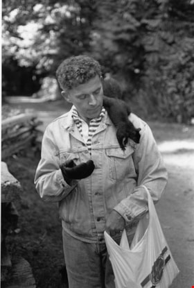
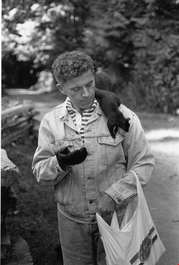
Ray Smith
https://search.heritageburnaby.ca/link/archivedescription78821
- Repository
- City of Burnaby Archives
- Date
- January 17, 1996
- Collection/Fonds
- Burnaby NewsLeader photograph collection
- Description Level
- Item
- Physical Description
- 1 photograph : b&w ; 23 x 15.5 cm
- Scope and Content
- Photograph of Ray Smith feeding a squirrel while it rests on his shoulder at Deer Lake Park.
- Repository
- City of Burnaby Archives
- Date
- January 17, 1996
- Collection/Fonds
- Burnaby NewsLeader photograph collection
- Physical Description
- 1 photograph : b&w ; 23 x 15.5 cm
- Description Level
- Item
- Record No.
- 535-0138
- Access Restriction
- No restrictions
- Reproduction Restriction
- No reproduction permitted
- Accession Number
- 2012-11
- Scope and Content
- Photograph of Ray Smith feeding a squirrel while it rests on his shoulder at Deer Lake Park.
- Subjects
- Animals
- Geographic Features - Parks
- Names
- Smith, Ray
- Media Type
- Photograph
- Photographer
- Langdeau, Brian
- Notes
- Title based on contents of photograph
- Note in black and red ink on recto of photograph reads: "Bby - 1 - 97% / 50A Brian Bby"
- Trim marks and/or reproduction instructions on recto (scan is cropped)
Images
![Shawn Wade in Big Bend, [2002] thumbnail](/media/hpo/_Data/_Archives_Images/_Unrestricted/535/535-2910.jpg?width=280)
Shawn Wade in Big Bend
https://search.heritageburnaby.ca/link/archivedescription97571
- Repository
- City of Burnaby Archives
- Date
- [2002]
- Collection/Fonds
- Burnaby NewsLeader photograph collection
- Description Level
- Item
- Physical Description
- 1 photograph (tiff) : col.
- Scope and Content
- Photograph of Shawn Wade standing on the shoulder of a road in the Big Bend area. A farm and forested area are visible in the background.
- Repository
- City of Burnaby Archives
- Date
- [2002]
- Collection/Fonds
- Burnaby NewsLeader photograph collection
- Physical Description
- 1 photograph (tiff) : col.
- Description Level
- Item
- Record No.
- 535-2910
- Access Restriction
- No restrictions
- Reproduction Restriction
- No restrictions
- Accession Number
- 2018-12
- Scope and Content
- Photograph of Shawn Wade standing on the shoulder of a road in the Big Bend area. A farm and forested area are visible in the background.
- Media Type
- Photograph
- Photographer
- Bartel, Mario
- Notes
- Title based on caption
- Collected by editorial for use in a January 2002 issue of the Burnaby NewsLeader
- Caption from metadata: "Shawn Wade fears the unique rural character of Burnaby's Big Bend area will die if Burnaby council approves a plan for commercial development."
- Historic Neighbourhood
- Fraser Arm (Historic Neighbourhood)
- Planning Study Area
- Big Bend Area
Images
![Shawn Wade in Big Bend, [2002] thumbnail](/media/hpo/_Data/_Archives_Images/_Unrestricted/535/535-2910.jpg)