More like 'Capilano Dam'
Narrow Results By
Subject
- Documentary Artifacts 8
- Documentary Artifacts - Booklets 1
- Documentary Artifacts - Maps 1
- Documentary Artifacts - Photographs 2
- Documentary Artifacts - Postcards 7
- Exchange Medium 1
- Exchange Medium - Tickets 1
- Geographic Features 5
- Geographic Features - Forests 1
- Geographic Features - Parks 6
- Geographic Features - Roads 1
- Recreational Activities 1
postcard
https://search.heritageburnaby.ca/link/museumartifact84668
- Repository
- Burnaby Village Museum
- Accession Code
- BV007.43.1
- Description
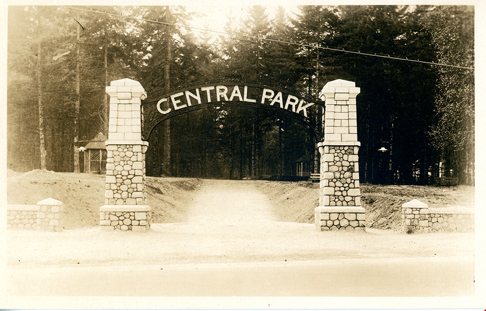
- postcard; black and white photograph of entrance arches to Central Park in Burnaby - [192-]. The postcard was published by the Gowen Sutton Company Limited of Vancouver, BC. Stamp in black ink on verso of postcard reads "PUBLISHED BY THE GOWEN SUTTON CO. LTD. VANCOUVER, B.C. / POSTCARD / CORRESPONDENCE_ADDRESS"
- Object History
- Souvenir postcard of Burnaby Central Park entrance arch.
- Classification
- Written Communication T&E - - Writing Media
- Object Term
- Postcard
- Colour
- Brown
- White
- Measurements
- w: 14 cm h: 9 cm
- Country Made
- Canada
- Province Made
- British Columbia
- Site/City Made
- Vancouver
- Subjects
- Structures - Arches
- Documentary Artifacts
- Documentary Artifacts - Postcards
- Geographic Features - Parks
- Geographic Access
- Central Park
- Imperial Street
- Street Address
- 3883 Imperial Street
- Historic Neighbourhood
- Central Park (Historic Neighbourhood)
- Planning Study Area
- Maywood Area
Images
postcard
https://search.heritageburnaby.ca/link/museumartifact35477
- Repository
- Burnaby Village Museum
- Accession Code
- BV993.43.1
- Description
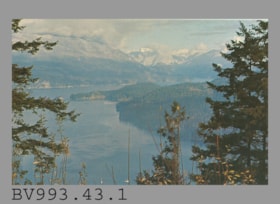
- The postcard face is a colour photo of Indian Arm from Burnaby Mountain Centennial Park in landscape format. Printed in navy on reverse at at upper left, "V-104" "INDIAN ARM FROM BURNABY MOUNTAIN" "Burnaby, B.C." "Looking North-West..."; illustration at left of R.C.M.P. officer; Printed at bottom left, "Photo by H. D. von Tiesenhausen" "S-1464"; This is a navy bar up centre with "PUB. BY NATURAL COLOR PRODUCTIONS, LTD., VANCOUVER, B.C."; at bottom, "MADE IN CANADA" "GRANT-MANN", logo of man, "LITHOGRAPHY" "PHOTOGRAPHY" "DESIGN" Printed at the upper right side of card is an illustration of mounted R.C.M.P. officer to the left of "POST CARD" "ADDRESS" and rectangle for stamp, "USE CANADIAN POSTAGE"; The card is unused
- Object History
- Purchased 1980/1981
- Classification
- Written Communication T&E - - Writing Media
- Object Term
- Postcard
- Country Made
- Canada
- Province Made
- British Columbia
- Site/City Made
- Vancouver
- Title
- Indian Arm from Burnaby Mountain S-1464
- Subjects
- Documentary Artifacts
- Documentary Artifacts - Postcards
- Geographic Features
- Geographic Features - Parks
Images

postcard
https://search.heritageburnaby.ca/link/museumartifact35478
- Repository
- Burnaby Village Museum
- Accession Code
- BV993.43.2
- Description
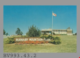
- Postcard: colour photo of Burnaby Mountain Park, Burnaby, BC, including the wooden Burnaby Mountain Park sign and Centennial Pavilion, built for the BC Centennial in 1958; horizontal; on reverse in blue, "2" "BURNABY MOUNTAIN PARK" "Burnaby, B.C., Canada" "The Centennial Pavilion..."; drawing of R.C.M.P. officer at left, mounted officer at right; at lower left, "Photo by George Allen Aerial Photos Ltd. For the Burnaby Parks & Recreation Commission" "S-2773"; blue line up centre with "PUB. BY NATURAL COLOR PRODUCTIONS, LTD., VANCOUVER, B.C."; at bottom, "MADE IN CANADA" "GRANT-MANN"; at upper right, "POST CARD" and rectangle for stamp, "USE CANADIAN POSTAGE"; "ADDRESS" below; unused
- Object History
- Purchased 1980/1981
- Classification
- Written Communication T&E - - Writing Media
- Object Term
- Postcard
- Country Made
- Canada
- Province Made
- British Columbia
- Site/City Made
- Vancouver
- Title
- Burnaby Mountain Park
- Subjects
- Documentary Artifacts
- Documentary Artifacts - Postcards
- Geographic Features
- Geographic Features - Parks
Images
postcard
https://search.heritageburnaby.ca/link/museumartifact44486
- Repository
- Burnaby Village Museum
- Accession Code
- BV002.30.1
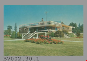
- Description
- Postcard: colour photo of Centennial Pavilion, Burnaby Mountain Park; horizontal; on reverse in navy, "4" "CENTENNIAL PAVILION" "Burnaby, B.C., Canada" "The Centennial Pavilion located..."; illustration at left of R.C.M.P. officer; at bottom, "Photo by George Allen Aerial Photos Ltd. For the Burnaby Parks & Recreation Commission" "S-2775"; navy bar up centre with "NATURAL COLOR PRODUCTIONS, LTD., VANCOUVER, B.C."; at bottom, "MADE IN CANADA" "GRANT-MANN", logo; at upper right, illustration of mounted R.C.M.P. officer, "POST CARD" "ADDRESS", and rectangle "USE CANADIAN POSTAGE"; in blue pen on left side, "July, 1977"
- Classification
- Written Communication T&E - - Writing Media
- Object Term
- Postcard
- Country Made
- Canada
- Province Made
- British Columbia
- Site/City Made
- Vancouver
- Title
- Centennial Pavilion Burnaby, B.C., Canada S-2775
- Publication Date
- July 1977
- Subjects
- Documentary Artifacts
- Documentary Artifacts - Postcards
- Documentary Artifacts - Photographs
- Geographic Features
- Geographic Features - Parks
Images

postcard
https://search.heritageburnaby.ca/link/museumartifact48137
- Repository
- Burnaby Village Museum
- Accession Code
- BV004.113.1
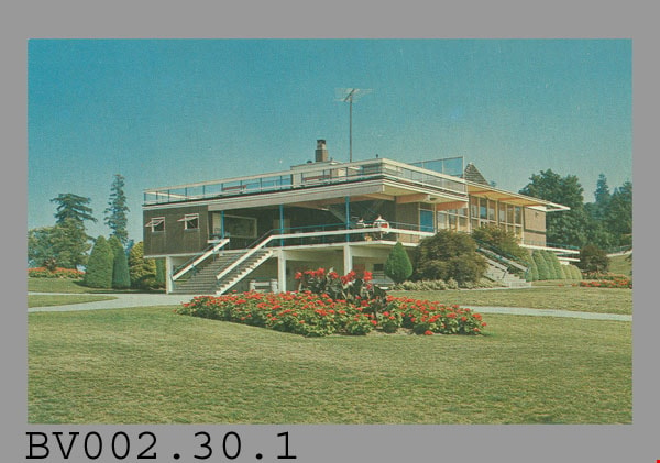
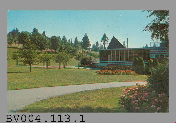
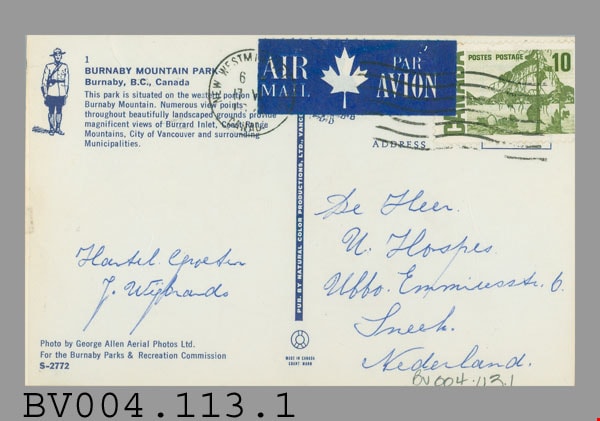
- Description
- Postcard: colour photograph of Burnaby Mountain Park including Centennial Pavilion; horizontal; on reverse in blue: "1" "BURNABY MOUNTAIN PARK" "Burnaby, B.C., Canada" "This park...", drawing of R.C.M.P. officer at left; photo by "George Allen Aerial Photos Ltd. For the Burnaby Parks & Recreation Commission" "S-2772"; blue bar up centre with "PUB. BY NATURAL COLOR PRODUCTIONS, LTD. VANC.-", rest covered; at bottom "MADE IN CANADA" "GRANT-MANN"; green 10 cent stamp at upper right; blue and white "AIR MAIL PAR AVION" label top centre; postmarked "NEW WESTMINSTER B.C. CANADA" "6 -" "17 -" "19--"; cancelled with 7 wavy lines; under "ADDRESS" at right side, in blue pen, "De Heer" "U. Hospes." "Uffo. Emmiresstr. 6." "Sneet"? "Nederland."; message "Hantel Cproetin"? "J. Wisbrands"?; corners slightly worn
- Classification
- Written Communication T&E - - Writing Media
- Object Term
- Postcard
- Marks/Labels
- Burnaby Mountain Park / Burnaby, B.C., Canada / George Allen Aerial Photos Ltd. / Burnaby Parks and Recreation Commission / S-2772
- Country Made
- Canada
- Province Made
- British Columbia
- Site/City Made
- Vancouver
- Title
- Burnaby Mountain Park 1 S-2772
- Publication Date
- [ca. 1970]
- Subjects
- Documentary Artifacts
- Documentary Artifacts - Postcards
- Documentary Artifacts - Photographs
- Geographic Features
- Geographic Features - Parks
Images

postcard
https://search.heritageburnaby.ca/link/museumartifact84669
- Repository
- Burnaby Village Museum
- Accession Code
- BV007.43.2
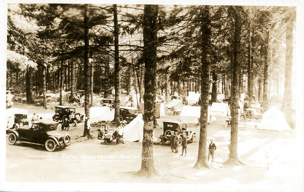
- Description
- postcard; Auto Tourist Camp - Postcard -- [1926]. Postcard with a black and white photograph; inscription in white at bottom reads: "Auto Tourist Camp, Central Park B.C." The postcard was published by the Gowen Sutton Company Limited of Vancouver, BC. Verso of postcard includes a postage stamp with King George in the upper right corner and is post marked Sept. 6 and includes a handwritten letter by "Violet" and is addressed to "Roseline Rondeau.../ Oregon".
- Classification
- Written Communication T&E - - Writing Media
- Object Term
- Postcard
- Colour
- Brown
- Black
- White
- Measurements
- w: 14 cm h: 9 cm
- Country Made
- Canada
- Province Made
- British Columbia
- Site/City Made
- Vancouver
- Subjects
- Documentary Artifacts
- Documentary Artifacts - Postcards
- Geographic Features
- Geographic Features - Parks
- Recreational Activities
- Recreational Activities - Camping
- Names
- Central Park Auto Camp
- Historic Neighbourhood
- Central Park (Historic Neighbourhood)
Images
postcard
https://search.heritageburnaby.ca/link/museumartifact45453
- Repository
- Burnaby Village Museum
- Accession Code
- BV003.26.5
- Description
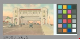
- Postcard: coloured illustration, horizontal; shows the Burrard Street Bridge with cars crossing it; view appears to be looking north as the Hotel Vancouver can be seen off to the left; in red at top, "Burrard Street Bridge Vancouver, B.C., Canada."; on reverse in black, "POST CARD", line down centre; at left, "Message May Be Written On This Side"; at right, "Address Only On This Side"; up left side, THE COAST PUBLISHING CO., VANCOUVER, B.C."; outline of rectangle at upper right, "PLACE STAMP HERE" "C.P. 157"; unused; discolouration, creases, some wear at corners; NOTE that although the bridge opened in 1932 the postcard appears to have been created at a later date, as the Hotel Vancouver did not open until 1939; hotel is on the east side of Burrard
- Object History
- Purchased from E-Bay, #2163154620.
- Classification
- Written Communication T&E - - Writing Media
- Object Term
- Postcard
- Maker
- Coast Publishing Company
- Country Made
- Canada
- Province Made
- British Columbia
- Site/City Made
- Vancouver
- Title
- Burrard Street Bridge Vancouver, B.C., Canada C.P. 157
- Publication Date
- [ca. 1940].
- Geographic Access
- Vancouver
Images

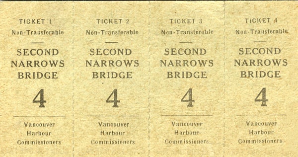
toll bridge ticket page
https://search.heritageburnaby.ca/link/museumartifact27663
- Repository
- Burnaby Village Museum
- Accession Code
- HV974.130.69
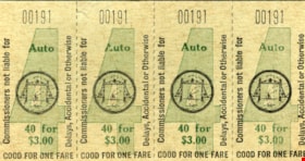
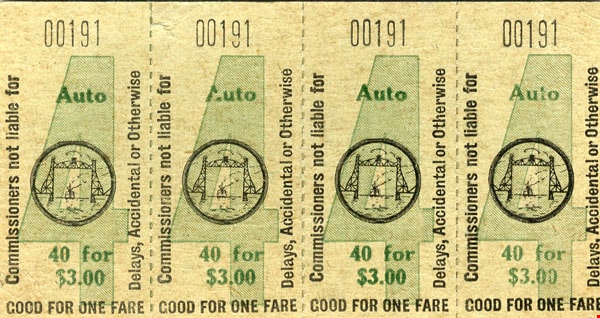
- Description
- Toll Bridge Tickets - Tickets. Four connected tickets for crossing the Second Narrows Bridge. The tickets are green with a small drawing of the bridge on them. On the top of each ticket is "00191" The tickets were produced by the Vancouver Harbour Commissioners.
- Object History
- From Denby Bros. Shoe Store at 163 West Pender in Vancouver. Stafford Ague Denby (1882-1957) started peddling shoe findings in 1918 around Vancouver to repair shops around town from the back of an old Ford. Two of his brothers, William Albert (1873-1947) and Melvin Stanley (1879-1953) joined him in 1919 to form Denby Bros & Co. Ltd Leather and Shoe Findings at 163 West Pender. William Gordon Pope started helping out in the shoe store at the age of 10. He eventually ran the store with his cousin, Pat Denby (son of William A. Denby) starting in the 1950s. The store closed in 1974.
- Subjects
- Exchange Medium
- Exchange Medium - Tickets
- Transportation
- Transportation - Automobiles
- Structures
- Structures - Bridges
Images

![Copy of Official British Columbia Road Maps, [193-] thumbnail](/media/hpo/_Data/_BVM_Cartographic_Material/1972/1972_0179_0001_001.jpg?width=280)
Copy of Official British Columbia Road Maps
https://search.heritageburnaby.ca/link/museumdescription18945
- Repository
- Burnaby Village Museum
- Date
- [193-]
- Collection/Fonds
- Burnaby Village Museum Map collection
- Physical Description
- 1 map : lithographic print on sheet ; 43 x 56 cm folded to 22 x 11 cm
- Scope and Content
- Item consists of Road maps of British Columbia presented by Union Oil Company of Canada Limited. Includes seventeen maps printed on both sides of sheet. One side of sheet includes ten separate road maps titled "Cariboo"; "Chilcotin Plateau"; "150 Mile House to Prince George"; "Prince George - Burns…
- Repository
- Burnaby Village Museum
- Collection/Fonds
- Burnaby Village Museum Map collection
- Physical Description
- 1 map : lithographic print on sheet ; 43 x 56 cm folded to 22 x 11 cm
- Material Details
- Scale not defined
- Scope and Content
- Item consists of Road maps of British Columbia presented by Union Oil Company of Canada Limited. Includes seventeen maps printed on both sides of sheet. One side of sheet includes ten separate road maps titled "Cariboo"; "Chilcotin Plateau"; "150 Mile House to Prince George"; "Prince George - Burns Lake"; "Burns Lake - Hazelton"; "Similkameen - Nicola"; "Salmon Arm to Revelstoke"; "Ashcroft to Salmon Arm / Kamloops to Vernon"; "Okanagan Valley"; "Boundary District". Other side of sheet includes seven road maps titled "Vancouver Island"; "Vancouver to Yale"' "Fraser Canyon Section Cariboo Road"; "Lytton to 150 Mile House"; "Arrow and Kootenay Lakes"; "The Kootenays"; "Columbia Valley". When folded, cover of maps reads "COPY OF / OFFICIAL / BRITISH COLUMBIA / ROAD-MAPS" / Presented by / UNION OIL / COMPANY / of Canada Ltd."; verso of cover includes advertisement for Union Motor oil "MOTORITE"; inside cover includes advertisement for Union Gasoline with title reading "See Canada's Evergreen Playground".
- Responsibility
- Union Oil Company of Canada Limited
- Accession Code
- HV972.179.1
- Access Restriction
- No restrictions
- Reproduction Restriction
- No known restrictions
- Date
- [193-]
- Media Type
- Cartographic Material
- Scan Resolution
- 600
- Scan Date
- 2023-08-17
- Notes
- Title based on contents of map
Images
![Copy of Official British Columbia Road Maps, [193-] thumbnail](/media/hpo/_Data/_BVM_Cartographic_Material/1972/1972_0179_0001_001.jpg)

![Survey and Subdivision plans in New Westminster District Group 1 – Burnaby
, [1908] thumbnail](/media/hpo/_Data/_BVM_Cartographic_Material/1977/1977_0093_0004a_001.jpg?width=280)
Survey and Subdivision plans in New Westminster District Group 1 – Burnaby
https://search.heritageburnaby.ca/link/museumdescription6973
- Repository
- Burnaby Village Museum
- Date
- [1908]
- Collection/Fonds
- Burnaby Village Museum Map collection
- Description Level
- File
- Physical Description
- 10 plans : blueprint ink on paper mounted on 2 sides of cardboard ; 76 cm x 102 cm
- Scope and Content
- Item consists of a large board of four New Westminster District Gp 1 - subdivision plans mounted on one side and six New Westminster District Gp 1 - subdivision plans mounted on the other side. Side A: 1. Blueprint "Plan / of - ReSubdivision / of / Lots 1-18 inclusive / Blocks 20 and 21 / in Sub…
- Repository
- Burnaby Village Museum
- Collection/Fonds
- Burnaby Village Museum Map collection
- Description Level
- File
- Physical Description
- 10 plans : blueprint ink on paper mounted on 2 sides of cardboard ; 76 cm x 102 cm
- Material Details
- Scales [between 1:792 and 1:4752]
- Index number on edge of board reads: "4"
- Scope and Content
- Item consists of a large board of four New Westminster District Gp 1 - subdivision plans mounted on one side and six New Westminster District Gp 1 - subdivision plans mounted on the other side. Side A: 1. Blueprint "Plan / of - ReSubdivision / of / Lots 1-18 inclusive / Blocks 20 and 21 / in Subdivision / of / Lot 53 -Gr.1 / New Westminster District" / "Subdivision Lot Numbers - Shown in Red". Plan is bordered by First Street / Jorgenson's Line / Fourth Avenue and Second Street with Fifith Avenue running through the centre. There is an index in the upper right corner of the plan. Planned is signed by "Peter Byrne" and "William R. Phillips" and dated July 28, 1908. (Geographic location: Burnaby) 2. Blueprint "Plan / of Subdivision / of / Lot 159 / and a Portion of Lot 158 / Group One / New Westminster District". Plan is bordered by Lots 96 and 97; South Wilson Street; North Arm Road and Lot 160 / Power House Road (Lot 155 A). B.C.E.R. Gilley Station is identified in the upper right corner of the plan. (Geographic location: Burnaby) 3. Blueprint plan identified as "Subdvs 10, L 88 and Lot 25, G. 1" Plan identifies Cumberland Street running from top to the bottom and a Ravine running alongside with the Jensen house, stable and barn. (Geographic location: Burnaby) 4. Blueprint Plan of "Lot 153. G. 1 /New Westminster District". Plan identifies the "New Westminster & Vancouver Tramway" and the "New Westminster and Vancouver Road" running through the plan of Lot 53. (Geographic location: Burnaby) Side B: 1. Blueprint plan of "Profile on Proposed North Rd. Diversion". 2. Blueprint plan (no title) showing wood lots north of Burnaby Lake and Brunette River and west of North Road. Various lots are identified as "Heavily Timbered" (Lot 57); "Splendid Fir and Cedar / Heavy Fir etc. / Fine Cedar" (Lots 143, 148); "Rough Light Timber," (Lot 56); "Some Fir and Cedar" (Lot 40). (Geographic location: Burnaby) 3. Blueprint "Plan / of Subdivision / of a Portion / of Lot 87, Gr.1 / New Westminster District". Plan is bordered by Burnaby Lake at the top and Hastings Road / Lot 86 at the bottom and Lot 90 to the east. "Albert J. Hill B.C.LotS." Annotation in ink reads: " J.A. Brownlee, B.C.L.S. / Subdivision / Map 1494 / Bd. 248". Plan is signed by "Peter Byrne, Reeve" (Geographic location: Burnaby) 4. Blueprint plan of Subdivisions along either side of Douglas Road including Lots 117; 119; 74; 80; 79 and 77. (Geographic location: Burnaby) 5. Blueprint "Plan / of / Subdivision of / Lot 27 / in Subdivision / of / Lot 30 / Group One / New Westminster District" Plan is bordered by Lot 26, Lot 28 and Hastings Rd. Lot 27 runs north of Edmonds Street. , "Albert J. Hill, B.C.LotS." (Geographic location: Burnaby) 6. Blueprint plan identified as a "Cultivated Orchard" including the names "W. Grace" and "G. Mead" located north of the North Arm Fraser River and west of "Twentieth Street_ City Boundary". Handwritten annotation in coloured pencil reads: "Portion of Lot 172" (Geographic location: Burnaby)
- Subjects
- Geographic Features - Forests
- Geographic Access
- Cumberland Street
- North Road
- Hastings Street
- Douglas Road
- Accession Code
- HV977.93.4
- Access Restriction
- No restrictions
- Reproduction Restriction
- No known restrictions
- Date
- [1908]
- Media Type
- Cartographic Material
- Historic Neighbourhood
- Burnaby Lake (Historic Neighbourhood)
- Fraser Arm (Historic Neighbourhood)
- Planning Study Area
- Douglas-Gilpin Area
- Burnaby Lake Area
- Scan Resolution
- 300
- Scale
- 72
- Notes
- Title based on contents of file
- Scale is measured in chains. (One chain equals 792 inches)
- The term "Lot" can also refer to a "District Lot”-
Images
![Survey and Subdivision plans in New Westminster District Group 1 – Burnaby
, [1908] thumbnail](/media/hpo/_Data/_BVM_Cartographic_Material/1977/1977_0093_0004a_001.jpg)

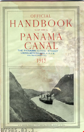
pamphlet
https://search.heritageburnaby.ca/link/museumartifact6576
- Repository
- Burnaby Village Museum
- Accession Code
- BV985.83.3
- Description
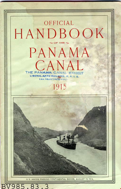
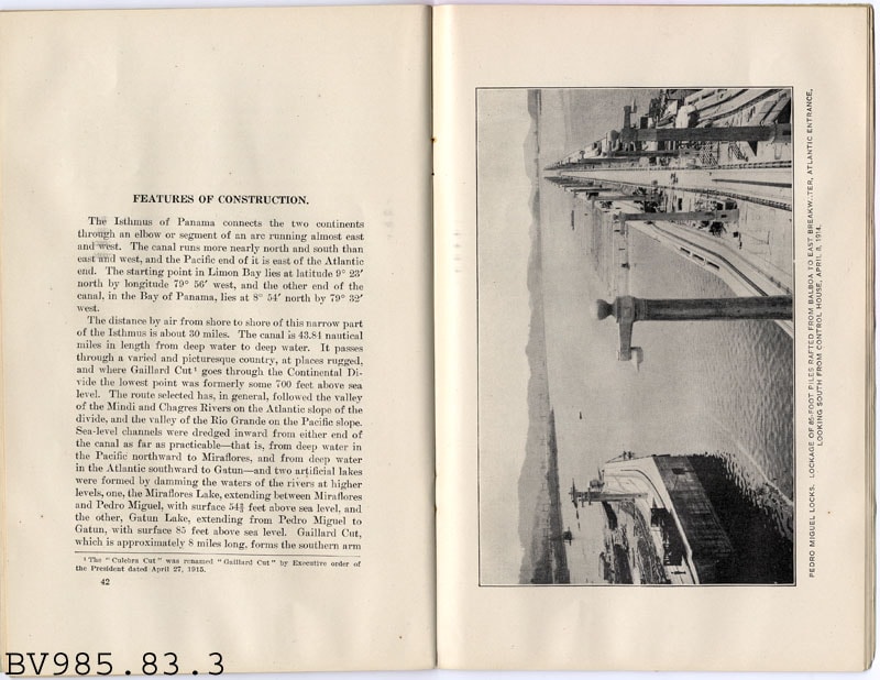
- Official Handbook of the Panama Canal - Booklet -- [1915]. Booklet created by the Washington Government Printing Office. The booklet provides information about shipping facilities, distance saved, cost saving of the canal, tolls, traffic routes, and the Navy's use of the canal. The cover of the booklet is light green with a photograph of a ship passing through the calan. The title of the booklet is printed in red. The cover has been stamped by The Panama Canal Exhibit in San Francisco.
- Country Made
- United States of America
- Province Made
- District of Columbia
- Site/City Made
- Washington
- Title
- Official Handbook of the Panama Canal
- Publication Date
- 1915
Images