More like 'Building site'
Narrow Results By
Subject
- Accidents - Automobile Accidents 1
- Advertising Medium 3
- Advertising Medium - Signs and Signboards 83
- Aerial Photographs 31
- Agricultural Tools and Equipment - Plows 3
- Agriculture 2
- Agriculture - Crops 2
- Agriculture - Farms 49
- Agriculture - Fruit and Berries 5
- Agriculture - Poultry 4
- Animals - Birds 2
- Animals - Cats 5
4806 Hastings Street
https://search.heritageburnaby.ca/link/archivedescription94342
- Repository
- City of Burnaby Archives
- Date
- July 1995
- Collection/Fonds
- Grover, Elliott & Co. Ltd. fonds
- Description Level
- File
- Physical Description
- 25 photographs : col. negatives ; 35 mm
- Scope and Content
- Photographs of the 4700 and 4800 blocks of Hastings Street. Businesses visible in the photographs include Pizza Hut and Jan's Grocery.
- Repository
- City of Burnaby Archives
- Date
- July 1995
- Collection/Fonds
- Grover, Elliott & Co. Ltd. fonds
- Physical Description
- 25 photographs : col. negatives ; 35 mm
- Description Level
- File
- Record No.
- 622-127
- Access Restriction
- No restrictions
- Reproduction Restriction
- No restrictions
- Accession Number
- 2017-39
- Scope and Content
- Photographs of the 4700 and 4800 blocks of Hastings Street. Businesses visible in the photographs include Pizza Hut and Jan's Grocery.
- Media Type
- Photograph
- Notes
- Transcribed title
- Title transcribed from envelope photographs were originally housed in
- File no. 95-249-B
- Photographer identified as "K.H."
- Geographic Access
- Hastings Street
- Historic Neighbourhood
- Capitol Hill (Historic Neighbourhood)
- Planning Study Area
- Capitol Hill Area
7026 Kingsway
https://search.heritageburnaby.ca/link/archivedescription94304
- Repository
- City of Burnaby Archives
- Date
- January 1994
- Collection/Fonds
- Grover, Elliott & Co. Ltd. fonds
- Description Level
- File
- Physical Description
- 19 photographs : col. negatives ; 35 mm
- Scope and Content
- Photographs of commercial and undeveloped properties located in the 7100 block of Kingsway, including Middlegate Honda, with mid-rise towers visible in the background.
- Repository
- City of Burnaby Archives
- Date
- January 1994
- Collection/Fonds
- Grover, Elliott & Co. Ltd. fonds
- Physical Description
- 19 photographs : col. negatives ; 35 mm
- Description Level
- File
- Record No.
- 622-089
- Access Restriction
- No restrictions
- Reproduction Restriction
- No restrictions
- Accession Number
- 2017-39
- Scope and Content
- Photographs of commercial and undeveloped properties located in the 7100 block of Kingsway, including Middlegate Honda, with mid-rise towers visible in the background.
- Media Type
- Photograph
- Notes
- Transcribed title
- Title transcribed from envelope photographs were originally housed in
- File no. 94-028-B
- Photographer identified as "L.D."
- Geographic Access
- Kingsway
- Historic Neighbourhood
- Edmonds (Historic Neighbourhood)
- Planning Study Area
- Stride Avenue Area
![Ann Greensill in Ming Wo, [2001] thumbnail](/media/hpo/_Data/_Archives_Images/_Unrestricted/535/535-2969.jpg?width=280)
Ann Greensill in Ming Wo
https://search.heritageburnaby.ca/link/archivedescription97686
- Repository
- City of Burnaby Archives
- Date
- [2001]
- Collection/Fonds
- Burnaby NewsLeader photograph collection
- Description Level
- Item
- Physical Description
- 1 photograph (tiff) : col.
- Scope and Content
- Photograph of Ann Greensill, the manager of Ming Wo Cookware in Lougheed Mall, holding up three Cuisipro whisks.
- Repository
- City of Burnaby Archives
- Date
- [2001]
- Collection/Fonds
- Burnaby NewsLeader photograph collection
- Physical Description
- 1 photograph (tiff) : col.
- Description Level
- Item
- Record No.
- 535-2969
- Access Restriction
- No restrictions
- Reproduction Restriction
- No restrictions
- Accession Number
- 2018-12
- Scope and Content
- Photograph of Ann Greensill, the manager of Ming Wo Cookware in Lougheed Mall, holding up three Cuisipro whisks.
- Names
- Lougheed Town Centre
- Media Type
- Photograph
- Photographer
- Bartel, Mario
- Notes
- Title based on caption
- Collected by editorial for use in a December 2001 issue of the Burnaby NewsLeader
- Caption from metadata: "Ann Greensill, the manager of Ming Wo in Lougheed Mall, shows off a set of Cuisipro whisks, made of heat-resistant silicon and soft enough to be used in non-stick pans."
- Geographic Access
- Austin Road
- Lougheed Highway
- Street Address
- 9855 Austin Avenue
- Historic Neighbourhood
- Burquitlam (Historic Neighbourhood)
- Planning Study Area
- Cameron Area
Images
![Ann Greensill in Ming Wo, [2001] thumbnail](/media/hpo/_Data/_Archives_Images/_Unrestricted/535/535-2969.jpg)

Bakery Opposite Capitol Hill School
https://search.heritageburnaby.ca/link/archivedescription93647
- Repository
- City of Burnaby Archives
- Date
- November 20, 1977
- Collection/Fonds
- Burnaby Public Library Contemporary Visual Archive Project
- Description Level
- Item
- Physical Description
- 1 photograph : b&w ; 12.5 x 17.5 cm
- Scope and Content
- Photograph of the exterior and the parking lot of a bakery on the corner of Holdom Avenue and Hastings Street, across from Capitol Hill Elementary School. The sign reads "Mackey Fine Foods." The photograph is taken facing north from the other side of Hastings Street.
- Repository
- City of Burnaby Archives
- Date
- November 20, 1977
- Collection/Fonds
- Burnaby Public Library Contemporary Visual Archive Project
- Physical Description
- 1 photograph : b&w ; 12.5 x 17.5 cm
- Description Level
- Item
- Record No.
- 556-604
- Access Restriction
- No restrictions
- Reproduction Restriction
- Reproduce for fair dealing purposes only
- Accession Number
- 2017-57
- Scope and Content
- Photograph of the exterior and the parking lot of a bakery on the corner of Holdom Avenue and Hastings Street, across from Capitol Hill Elementary School. The sign reads "Mackey Fine Foods." The photograph is taken facing north from the other side of Hastings Street.
- Media Type
- Photograph
- Photographer
- Chapman, Fred
- Notes
- Title taken from project information form
- Accompanied by a project information form and 1 photograph (b&w negative ; 9.5 x 12.5 cm)
- BPL no. 54
- Geographic Access
- Holdom Avenue
- Hastings Street
- Historic Neighbourhood
- Capitol Hill (Historic Neighbourhood)
- Planning Study Area
- Capitol Hill Area
Images


BC Tel Building
https://search.heritageburnaby.ca/link/archivedescription93609
- Repository
- City of Burnaby Archives
- Date
- October 16, 1977
- Collection/Fonds
- Burnaby Public Library Contemporary Visual Archive Project
- Description Level
- Item
- Physical Description
- 1 photograph : b&w ; 12.5 x 17.5 cm
- Scope and Content
- Photograph of the BC Tel Building (now the Brian Canfield Centre), located at Kingsway and Boundary Road. The photograph is taken facing north and shows the pedestrian overpass over Kingsway and the mountains in the background.
- Repository
- City of Burnaby Archives
- Date
- October 16, 1977
- Collection/Fonds
- Burnaby Public Library Contemporary Visual Archive Project
- Physical Description
- 1 photograph : b&w ; 12.5 x 17.5 cm
- Description Level
- Item
- Record No.
- 556-566
- Access Restriction
- No restrictions
- Reproduction Restriction
- Reproduce for fair dealing purposes only
- Accession Number
- 2017-57
- Scope and Content
- Photograph of the BC Tel Building (now the Brian Canfield Centre), located at Kingsway and Boundary Road. The photograph is taken facing north and shows the pedestrian overpass over Kingsway and the mountains in the background.
- Media Type
- Photograph
- Photographer
- McGillivray, Don
- Notes
- Title taken from project information form
- Accompanied by a project information form and 1 photograph (b&w negative ; 9.5 x 12.5 cm)
- BPL no. 10
- Geographic Access
- Boundary Road
- Kingsway
- Street Address
- 3777 Kingsway
- Historic Neighbourhood
- Central Park (Historic Neighbourhood)
- Planning Study Area
- Garden Village Area
Images


BC Tel Building
https://search.heritageburnaby.ca/link/archivedescription93679
- Repository
- City of Burnaby Archives
- Date
- June 4, 1978
- Collection/Fonds
- Burnaby Public Library Contemporary Visual Archive Project
- Description Level
- Item
- Physical Description
- 1 photograph : b&w ; 12.5 x 17.5 cm
- Scope and Content
- Photograph of the exterior of the BC Tel Building, located at Kingsway and Boundary Road. The photograph is taken from across a lawn and railway tracks, facing southeast. The railway tracks are visible in the bottom left corner of the photograph.
- Repository
- City of Burnaby Archives
- Date
- June 4, 1978
- Collection/Fonds
- Burnaby Public Library Contemporary Visual Archive Project
- Physical Description
- 1 photograph : b&w ; 12.5 x 17.5 cm
- Description Level
- Item
- Record No.
- 556-636
- Access Restriction
- No restrictions
- Reproduction Restriction
- Reproduce for fair dealing purposes only
- Accession Number
- 2017-57
- Scope and Content
- Photograph of the exterior of the BC Tel Building, located at Kingsway and Boundary Road. The photograph is taken from across a lawn and railway tracks, facing southeast. The railway tracks are visible in the bottom left corner of the photograph.
- Media Type
- Photograph
- Photographer
- Chapman, Fred
- Notes
- Title taken from project information form
- Accompanied by a project information form and 1 photograph (b&w negative ; 9.5 x 12.5 cm)
- BPL no. 85
- Geographic Access
- Boundary Road
- Kingsway
- Street Address
- 3777 Kingsway
- Historic Neighbourhood
- Central Park (Historic Neighbourhood)
- Planning Study Area
- Garden Village Area
Images


BC Tel Building
https://search.heritageburnaby.ca/link/archivedescription93680
- Repository
- City of Burnaby Archives
- Date
- June 4, 1978
- Collection/Fonds
- Burnaby Public Library Contemporary Visual Archive Project
- Description Level
- Item
- Physical Description
- 1 photograph : b&w ; 12.5 x 17.5 cm
- Scope and Content
- Photograph of the exterior of the BC Tel Building, located at Kingsway and Boundary Road, and the lawn and neighbourhood surrounding the building. The photograph is taken from across the lawn, facing north. Boundary Road is on the left side of the photograph and the mountains are visible in the bac…
- Repository
- City of Burnaby Archives
- Date
- June 4, 1978
- Collection/Fonds
- Burnaby Public Library Contemporary Visual Archive Project
- Physical Description
- 1 photograph : b&w ; 12.5 x 17.5 cm
- Description Level
- Item
- Record No.
- 556-637
- Access Restriction
- No restrictions
- Reproduction Restriction
- Reproduce for fair dealing purposes only
- Accession Number
- 2017-57
- Scope and Content
- Photograph of the exterior of the BC Tel Building, located at Kingsway and Boundary Road, and the lawn and neighbourhood surrounding the building. The photograph is taken from across the lawn, facing north. Boundary Road is on the left side of the photograph and the mountains are visible in the background.
- Media Type
- Photograph
- Photographer
- Chapman, Fred
- Notes
- Title taken from project information form
- Accompanied by a project information form and 1 photograph (b&w negative ; 9.5 x 12.5 cm)
- BPL no. 86
- Geographic Access
- Kingsway
- Boundary Road
- Street Address
- 3777 Kingsway
- Historic Neighbourhood
- Central Park (Historic Neighbourhood)
- Planning Study Area
- Garden Village Area
Images

![Camping out for new Star Wars, [2002] thumbnail](/media/hpo/_Data/_Archives_Images/_Unrestricted/535/535-2353.jpg?width=280)
Camping out for new Star Wars
https://search.heritageburnaby.ca/link/archivedescription96795
- Repository
- City of Burnaby Archives
- Date
- [2002]
- Collection/Fonds
- Burnaby NewsLeader photograph collection
- Description Level
- Item
- Physical Description
- 1 photograph (tiff) : col.
- Scope and Content
- Photograph of Hanson Lok, Brent Morning-Smith, Stephen Lee, and Iku Yeh in line for the new Star Wars movie at Metropolis. They are camping out in a tent and have plastic light sabers.
- Repository
- City of Burnaby Archives
- Date
- [2002]
- Collection/Fonds
- Burnaby NewsLeader photograph collection
- Physical Description
- 1 photograph (tiff) : col.
- Description Level
- Item
- Record No.
- 535-2353
- Access Restriction
- No restrictions
- Reproduction Restriction
- No restrictions
- Accession Number
- 2018-12
- Scope and Content
- Photograph of Hanson Lok, Brent Morning-Smith, Stephen Lee, and Iku Yeh in line for the new Star Wars movie at Metropolis. They are camping out in a tent and have plastic light sabers.
- Names
- Metrotown
- Media Type
- Photograph
- Photographer
- Bartel, Mario
- Notes
- Title based on caption
- Collected by editorial for use in a May 2002 issue of the Burnaby NewsLeader
- Caption from metadata: "Hanson Lok, Brent Morning-Smith, Stephen Lee and Iku Yeh make sure the force will be with them to get prime seats for the premiere of the latest Star Wars movie, early Thursday morning. They started camping out in front of Metropolis on Monday afternoon."
- Geographic Access
- Kingsway
- Street Address
- 4700 Kingsway
- Historic Neighbourhood
- Central Park (Historic Neighbourhood)
- Planning Study Area
- Maywood Area
Images
![Camping out for new Star Wars, [2002] thumbnail](/media/hpo/_Data/_Archives_Images/_Unrestricted/535/535-2353.jpg)

Canada Way Food Market
https://search.heritageburnaby.ca/link/archivedescription79111
- Repository
- City of Burnaby Archives
- Date
- October, 1976
- Collection/Fonds
- Burnaby Public Library Contemporary Visual Archive Project
- Description Level
- Item
- Physical Description
- 1 photograph : b&w ; 11 x 16 cm mounted on cardboard
- Scope and Content
- Photograph shows the Canada Way Food Market at 4694 Canada Way and International Meats at 4692 Canada Way.
- Repository
- City of Burnaby Archives
- Date
- October, 1976
- Collection/Fonds
- Burnaby Public Library Contemporary Visual Archive Project
- Physical Description
- 1 photograph : b&w ; 11 x 16 cm mounted on cardboard
- Description Level
- Item
- Record No.
- 556-159
- Access Restriction
- No restrictions
- Reproduction Restriction
- Reproduce for fair dealing purposes only
- Accession Number
- 2013-13
- Scope and Content
- Photograph shows the Canada Way Food Market at 4694 Canada Way and International Meats at 4692 Canada Way.
- Media Type
- Photograph
- Photographer
- Salmon, Stu
- Notes
- Scope note taken directly from BPL photograph description.
- 1 b&w copy negative : 10 x 12.5 cm accompanying
- Geographic Access
- Canada Way
- Street Address
- 4692 Canada Way
- 4694 Canada Way
- Planning Study Area
- Douglas-Gilpin Area
Images


Canadian Food Market
https://search.heritageburnaby.ca/link/archivedescription98666
- Repository
- City of Burnaby Archives
- Date
- 2022
- Collection/Fonds
- Disappearing Burnaby collection
- Description Level
- Item
- Physical Description
- 1 photograph (jpeg) : col.
- Scope and Content
- Photograph of the exterior of the Canadian Food Market, taken from across Imperial Street at night. The grocery store is located at 4378 Imperial Street and the building was constructed in 1962. A large display of plants and flowers stands in front of the store and is illuminated by bright lights.
- Repository
- City of Burnaby Archives
- Date
- 2022
- Collection/Fonds
- Disappearing Burnaby collection
- Physical Description
- 1 photograph (jpeg) : col.
- Description Level
- Item
- Record No.
- 634-013
- Access Restriction
- No restrictions
- Reproduction Restriction
- No restrictions
- Accession Number
- 2022-14
- Scope and Content
- Photograph of the exterior of the Canadian Food Market, taken from across Imperial Street at night. The grocery store is located at 4378 Imperial Street and the building was constructed in 1962. A large display of plants and flowers stands in front of the store and is illuminated by bright lights.
- Media Type
- Photograph
- Photographer
- Cheung, Nakita
- Notes
- Title taken from the associated blog post
- Associated blog post: https://disappearingburnaby.wordpress.com/2022/02/20/imperial-manor-2/
- Geographic Access
- Imperial Street
- Street Address
- 4378 Imperial Street
- Historic Neighbourhood
- Central Park (Historic Neighbourhood)
- Planning Study Area
- Sussex-Nelson Area
Images

![Carnarvon Street Building, [1912] thumbnail](/media/hpo/_Data/_Archives_Images/_Unrestricted/477/477-939.jpg?width=280)
Carnarvon Street Building
https://search.heritageburnaby.ca/link/archivedescription66213
- Repository
- City of Burnaby Archives
- Date
- [1912]
- Collection/Fonds
- Peers Family and Hill Family fonds
- Description Level
- Item
- Physical Description
- 1 photograph : sepia ; 19.5 x 24 cm
- Scope and Content
- Photograph of the Carnarvon Street building in New Westminster, built by Claude Hill and E. B. Wetenhall (architect). Three cars can be seen on the street, one with two unidentified men seated inside. A note on the back of the photograph indicates that the building in the background is the New We…
- Repository
- City of Burnaby Archives
- Date
- [1912]
- Collection/Fonds
- Peers Family and Hill Family fonds
- Physical Description
- 1 photograph : sepia ; 19.5 x 24 cm
- Description Level
- Item
- Record No.
- 477-939
- Access Restriction
- No restrictions
- Reproduction Restriction
- No known restrictions
- Accession Number
- 2007-12
- Scope and Content
- Photograph of the Carnarvon Street building in New Westminster, built by Claude Hill and E. B. Wetenhall (architect). Three cars can be seen on the street, one with two unidentified men seated inside. A note on the back of the photograph indicates that the building in the background is the New Westminster Opera House and a sign on the building in the foreground reads "Ford Cars - Fraser Valley Motor Co. Limited."
- Subjects
- Transportation - Automobiles
- Buildings - Commercial
- Buildings - Commercial - Automobile Dealerships
- Media Type
- Photograph
- Notes
- Title based on contents of photograph
- Note on verso reads: "Carnarvon St. Bldg. / built by L.C. Hill & EB Wetenhall (architect) / old New Westminster Opera House / r. background - / app. 1912 -"
Images
![Carnarvon Street Building, [1912] thumbnail](/media/hpo/_Data/_Archives_Images/_Unrestricted/477/477-939.jpg)
![Commercial realtor Scott Brown, [2002] thumbnail](/media/hpo/_Data/_Archives_Images/_Unrestricted/535/535-1970.jpg?width=280)
Commercial realtor Scott Brown
https://search.heritageburnaby.ca/link/archivedescription96287
- Repository
- City of Burnaby Archives
- Date
- [2002]
- Collection/Fonds
- Burnaby NewsLeader photograph collection
- Description Level
- Item
- Physical Description
- 1 photograph (tiff) : col.
- Scope and Content
- Photograph of commercial real estate broker Scott Brown. Brown is standing in front of the Madison Centre on Lougheed Highway with his arms wide open. A sign in the window of the office tower reads: "For Lease."
- Repository
- City of Burnaby Archives
- Date
- [2002]
- Collection/Fonds
- Burnaby NewsLeader photograph collection
- Physical Description
- 1 photograph (tiff) : col.
- Description Level
- Item
- Record No.
- 535-1970
- Access Restriction
- No restrictions
- Reproduction Restriction
- No restrictions
- Accession Number
- 2018-12
- Scope and Content
- Photograph of commercial real estate broker Scott Brown. Brown is standing in front of the Madison Centre on Lougheed Highway with his arms wide open. A sign in the window of the office tower reads: "For Lease."
- Media Type
- Photograph
- Photographer
- Bartel, Mario
- Notes
- Title based on caption
- Collected by editorial for use in a February 2002 issue of the Burnaby NewsLeader
- Caption from metadata: "Scott Brown, a commercial real estate broker, says things are looking up for businesses looking for office space in Burnaby, as new space in buildings like the Madison Centre have increased the vacancy rates."
- Geographic Access
- Lougheed Highway
- Planning Study Area
- Brentwood Area
Images
![Commercial realtor Scott Brown, [2002] thumbnail](/media/hpo/_Data/_Archives_Images/_Unrestricted/535/535-1970.jpg)

Crossing Royal Oak & Rumble Street
https://search.heritageburnaby.ca/link/archivedescription93686
- Repository
- City of Burnaby Archives
- Date
- May 19, 1978
- Collection/Fonds
- Burnaby Public Library Contemporary Visual Archive Project
- Description Level
- Item
- Physical Description
- 1 photograph : b&w ; 12.5 x 17.5 cm
- Scope and Content
- Photograph of the intersection of Royal Oak Avenue and Rumble Street. Cars and pedestrians are crossing the intersection, and the signs for businesses TD Bank, Standard Oil/Chevron gas station, Gulf gas station, and Baxter's Market are visible. The photograph is taken from a corner of the intersect…
- Repository
- City of Burnaby Archives
- Date
- May 19, 1978
- Collection/Fonds
- Burnaby Public Library Contemporary Visual Archive Project
- Physical Description
- 1 photograph : b&w ; 12.5 x 17.5 cm
- Description Level
- Item
- Record No.
- 556-643
- Access Restriction
- No restrictions
- Reproduction Restriction
- Reproduce for fair dealing purposes only
- Accession Number
- 2017-57
- Scope and Content
- Photograph of the intersection of Royal Oak Avenue and Rumble Street. Cars and pedestrians are crossing the intersection, and the signs for businesses TD Bank, Standard Oil/Chevron gas station, Gulf gas station, and Baxter's Market are visible. The photograph is taken from a corner of the intersection, facing southeast.
- Subjects
- Geographic Features - Roads
- Advertising Medium - Signs and Signboards
- Buildings - Commercial - Service Stations
- Transportation - Automobiles
- Buildings - Commercial
- Media Type
- Photograph
- Photographer
- van Mannen, Mark
- Notes
- Title taken from project information form
- Accompanied by a project information form and 1 photograph (b&w negative ; 9.5 x 12.5 cm)
- BPL no. 91
- Geographic Access
- Royal Oak Avenue
- Rumble Street
- Historic Neighbourhood
- Alta Vista (Historic Neighbourhood)
- Planning Study Area
- Sussex-Nelson Area
Images


Crossing Royal Oak & Rumble Street
https://search.heritageburnaby.ca/link/archivedescription93687
- Repository
- City of Burnaby Archives
- Date
- May 19, 1978
- Collection/Fonds
- Burnaby Public Library Contemporary Visual Archive Project
- Description Level
- Item
- Physical Description
- 1 photograph : b&w ; 12.5 x 17.5 cm
- Scope and Content
- Photograph of the intersection of Royal Oak Avenue and Rumble Street. Cars and pedestrians are crossing the intersection, and the signs for businesses Grace United Pharmacy, Standard Oil/Chevron gas station, Gulf gas station, and Royal Meats are visible. The photograph is taken from the Gulf gas st…
- Repository
- City of Burnaby Archives
- Date
- May 19, 1978
- Collection/Fonds
- Burnaby Public Library Contemporary Visual Archive Project
- Physical Description
- 1 photograph : b&w ; 12.5 x 17.5 cm
- Description Level
- Item
- Record No.
- 556-644
- Access Restriction
- No restrictions
- Reproduction Restriction
- Reproduce for fair dealing purposes only
- Accession Number
- 2017-57
- Scope and Content
- Photograph of the intersection of Royal Oak Avenue and Rumble Street. Cars and pedestrians are crossing the intersection, and the signs for businesses Grace United Pharmacy, Standard Oil/Chevron gas station, Gulf gas station, and Royal Meats are visible. The photograph is taken from the Gulf gas station parking lot, facing northwest.
- Subjects
- Advertising Medium - Signs and Signboards
- Geographic Features - Roads
- Transportation - Automobiles
- Buildings - Commercial
- Buildings - Commercial - Service Stations
- Media Type
- Photograph
- Photographer
- van Mannen, Mark
- Notes
- Title taken from project information form
- Accompanied by a project information form and 1 photograph (b&w negative ; 9.5 x 12.5 cm)
- BPL no. 92
- Geographic Access
- Royal Oak Avenue
- Rumble Street
- Historic Neighbourhood
- Alta Vista (Historic Neighbourhood)
- Planning Study Area
- Sussex-Nelson Area
Images

![Delivery driver Dylan Dupuis, [2000] thumbnail](/media/hpo/_Data/_Archives_Images/_Unrestricted/535/535-2681.jpg?width=280)
Delivery driver Dylan Dupuis
https://search.heritageburnaby.ca/link/archivedescription97284
- Repository
- City of Burnaby Archives
- Date
- [2000]
- Collection/Fonds
- Burnaby NewsLeader photograph collection
- Description Level
- Item
- Physical Description
- 1 photograph (tiff) : col.
- Scope and Content
- Photograph of Dylan Dupuis, a Panagopoulos pizza delivery driver, posing in the door of his car in uniform with a pizza delivery bag and a sign for the Arco service station behind him, near Kingsway and Gilley.
- Repository
- City of Burnaby Archives
- Date
- [2000]
- Collection/Fonds
- Burnaby NewsLeader photograph collection
- Physical Description
- 1 photograph (tiff) : col.
- Description Level
- Item
- Record No.
- 535-2681
- Access Restriction
- No restrictions
- Reproduction Restriction
- Reproduce for fair dealing purposes only
- Accession Number
- 2018-12
- Scope and Content
- Photograph of Dylan Dupuis, a Panagopoulos pizza delivery driver, posing in the door of his car in uniform with a pizza delivery bag and a sign for the Arco service station behind him, near Kingsway and Gilley.
- Media Type
- Photograph
- Photographer
- Bartel, Mario
- Notes
- Title based on caption
- Collected by editorial for use in a September 2000 issue of the Burnaby NewsLeader
- Caption from metadata: "The high price of gas is making it difficult for delivery drivers, like Dylan Dupuis, to make any money, and businesses are facing raising their prices to cover their increased costs."
- Geographic Access
- Kingsway
- Gilley Avenue
- Historic Neighbourhood
- Edmonds (Historic Neighbourhood)
- Planning Study Area
- Kingsway-Beresford Area
Images
![Delivery driver Dylan Dupuis, [2000] thumbnail](/media/hpo/_Data/_Archives_Images/_Unrestricted/535/535-2681.jpg)

Dick's Market
https://search.heritageburnaby.ca/link/archivedescription79125
- Repository
- City of Burnaby Archives
- Date
- October, 1976
- Collection/Fonds
- Burnaby Public Library Contemporary Visual Archive Project
- Description Level
- Item
- Physical Description
- 1 photograph : b&w ; 11 x 16 cm mounted on cardboard
- Scope and Content
- Photograph shows window at Dick's Market at 4152 Hastings Street.
- Repository
- City of Burnaby Archives
- Date
- October, 1976
- Collection/Fonds
- Burnaby Public Library Contemporary Visual Archive Project
- Physical Description
- 1 photograph : b&w ; 11 x 16 cm mounted on cardboard
- Description Level
- Item
- Record No.
- 556-168
- Access Restriction
- No restrictions
- Reproduction Restriction
- Reproduce for fair dealing purposes only
- Accession Number
- 2013-13
- Scope and Content
- Photograph shows window at Dick's Market at 4152 Hastings Street.
- Names
- Dick's Market
- Media Type
- Photograph
- Photographer
- Cook, Alan
- Notes
- Scope note taken directly from BPL photograph description.
- 1 b&w copy negative : 10 x 12.5 cm accompanying
- Geographic Access
- Hastings Street
- Street Address
- 4152 Hastings Street
- Historic Neighbourhood
- Vancouver Heights (Historic Neighbourhood)
- Planning Study Area
- Willingdon Heights Area
Images


Evelyn's Beauty Salon
https://search.heritageburnaby.ca/link/archivedescription79191
- Repository
- City of Burnaby Archives
- Date
- September 22, 1976
- Collection/Fonds
- Burnaby Public Library Contemporary Visual Archive Project
- Description Level
- Item
- Physical Description
- 1 photograph : b&w ; 11 x 16 cm mounted on cardboard
- Scope and Content
- Photograph shows Evelyn's Beauty Salon at 7030 Buller Avenue next door to the P&K Convenient Food Market.
- Repository
- City of Burnaby Archives
- Date
- September 22, 1976
- Collection/Fonds
- Burnaby Public Library Contemporary Visual Archive Project
- Physical Description
- 1 photograph : b&w ; 11 x 16 cm mounted on cardboard
- Description Level
- Item
- Record No.
- 556-199
- Access Restriction
- No restrictions
- Reproduction Restriction
- Reproduce for fair dealing purposes only
- Accession Number
- 2013-13
- Scope and Content
- Photograph shows Evelyn's Beauty Salon at 7030 Buller Avenue next door to the P&K Convenient Food Market.
- Media Type
- Photograph
- Photographer
- Ross, Martha
- Notes
- Scope note taken directly from BPL photograph description.
- 1 b&w copy negative : 10 x 12.5 cm accompanying
- Geographic Access
- Buller Avenue
- Street Address
- 7930 Buller Avenue
- Historic Neighbourhood
- Alta-Vista (Historic Neighbourhood)
- Planning Study Area
- Clinton-Glenwood Area
Images

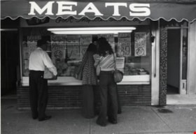
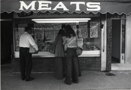
F & W Meat Market
https://search.heritageburnaby.ca/link/archivedescription79124
- Repository
- City of Burnaby Archives
- Date
- October, 1976
- Collection/Fonds
- Burnaby Public Library Contemporary Visual Archive Project
- Description Level
- Item
- Physical Description
- 1 photograph : b&w ; 11 x 16 cm mounted on cardboard
- Scope and Content
- Photograph shows people examining meat in the window of the F & W Meat Market at 4220 Hastings Street.
- Repository
- City of Burnaby Archives
- Date
- October, 1976
- Collection/Fonds
- Burnaby Public Library Contemporary Visual Archive Project
- Physical Description
- 1 photograph : b&w ; 11 x 16 cm mounted on cardboard
- Description Level
- Item
- Record No.
- 556-167
- Access Restriction
- No restrictions
- Reproduction Restriction
- Reproduce for fair dealing purposes only
- Accession Number
- 2013-13
- Scope and Content
- Photograph shows people examining meat in the window of the F & W Meat Market at 4220 Hastings Street.
- Names
- F & W Meat Market
- Media Type
- Photograph
- Photographer
- Cook, Alan
- Notes
- Scope note taken directly from BPL photograph description.
- 1 b&w copy negative : 10 x 12.5 cm accompanying
- Geographic Access
- Hastings Street
- Street Address
- 4220 Hastings Street
- Historic Neighbourhood
- Vancouver Heights (Historic Neighbourhood)
- Planning Study Area
- Willingdon Heights Area
Images
![Herb Neufeld's Christmas tree lot, [2001] thumbnail](/media/hpo/_Data/_Archives_Images/_Unrestricted/535/535-2975-1.jpg?width=280)
Herb Neufeld's Christmas tree lot
https://search.heritageburnaby.ca/link/archivedescription97700
- Repository
- City of Burnaby Archives
- Date
- [2001]
- Collection/Fonds
- Burnaby NewsLeader photograph collection
- Description Level
- File
- Physical Description
- 2 photographs (tiff) : col.
- Scope and Content
- File contains photographs of Herb Neufeld's Christmas tree lot at Middlegate Mall. Photographs depict Neufeld and his grandson Stewart Reimer unloading and stacking trees.
- Repository
- City of Burnaby Archives
- Date
- [2001]
- Collection/Fonds
- Burnaby NewsLeader photograph collection
- Physical Description
- 2 photographs (tiff) : col.
- Description Level
- File
- Record No.
- 535-2975
- Access Restriction
- No restrictions
- Reproduction Restriction
- No restrictions
- Accession Number
- 2018-12
- Scope and Content
- File contains photographs of Herb Neufeld's Christmas tree lot at Middlegate Mall. Photographs depict Neufeld and his grandson Stewart Reimer unloading and stacking trees.
- Media Type
- Photograph
- Photographer
- Bartel, Mario
- Notes
- Title based on caption
- Collected by editorial for use in a December 2001 issue of the Burnaby NewsLeader
- Caption from metadata for 535-2975-1: "Stewart Reimer unloads a new batch of Christmas trees at his grandfather's tree lot at Middlegate Mall. The trees are cut every day from a farm in Mission."
- Caption from metadata for 535-2975-2: "Herb Neufeld stacks a fresh load of Christmas trees at the tree lot he's been running at Middlegate Mall for the past 28 years. The trees are cut fresh every day at a farm in Mission. Neufeld says he expects to sell about 1200 trees by Christmas day."
- Geographic Access
- Kingsway
- Historic Neighbourhood
- Edmonds (Historic Neighbourhood)
- Planning Study Area
- Stride Avenue Area
Images
![Herb Neufeld's Christmas tree lot, [2001] thumbnail](/media/hpo/_Data/_Archives_Images/_Unrestricted/535/535-2975-1.jpg)
![Hill's Foods, [2001] thumbnail](/media/hpo/_Data/_Archives_Images/_Unrestricted/535/535-2202.jpg?width=280)
Hill's Foods
https://search.heritageburnaby.ca/link/archivedescription96580
- Repository
- City of Burnaby Archives
- Date
- [2001]
- Collection/Fonds
- Burnaby NewsLeader photograph collection
- Description Level
- Item
- Physical Description
- 1 photograph (tiff) : col.
- Scope and Content
- Photograph of Tina Hill in the freezer of her store Hill's Foods. Hill is displaying a box of frozen muskox meat.
- Repository
- City of Burnaby Archives
- Date
- [2001]
- Collection/Fonds
- Burnaby NewsLeader photograph collection
- Physical Description
- 1 photograph (tiff) : col.
- Description Level
- Item
- Record No.
- 535-2202
- Access Restriction
- No restrictions
- Reproduction Restriction
- No restrictions
- Accession Number
- 2018-12
- Scope and Content
- Photograph of Tina Hill in the freezer of her store Hill's Foods. Hill is displaying a box of frozen muskox meat.
- Media Type
- Photograph
- Photographer
- Bartel, Mario
- Notes
- Title based on caption
- Collected by editorial for use in a March 2001 issue of the Burnaby NewsLeader
- Caption from metadata: "Tina Hill, of Hill's Foods, shows off a frenched rack of Muskox from the Arctic, in her company's freezer stacked with various alternative and organic meats. She says interest in her company's offerings has increased with the livestock scares in Europe."
Images
![Hill's Foods, [2001] thumbnail](/media/hpo/_Data/_Archives_Images/_Unrestricted/535/535-2202.jpg)