More like 'Bottle'
Narrow Results By
Subject
- Advertising Medium - Signs and Signboards
- Agricultural Tools and Equipment 3
- Agriculture 1
- Agriculture - Crops 2
- Agriculture - Farms 1
- Agriculture - Ranches 1
- Animals - Dogs 1
- Animals - Horses 1
- Animals - Pigs 1
- Bedding - Quilt 1
- Buildings - Commercial - Grocery Stores 1
- Buildings - Commercial - Stores 4
sign
https://search.heritageburnaby.ca/link/museumartifact91782
- Repository
- Burnaby Village Museum
- Accession Code
- BV023.17.2
- Description
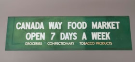
- Green store sign from Canada Way Food Market. Plasticized green sign with white lettering.
- There is a 2.5 cm band of residue running the length of the sign at the top and bottom.
- Object History
- Item was used in the Canada Way Food Market owned by Harry Toy between 1975 and the late 2000s. the building sat vacant until sold in 2023.
- Category
- 08. Communication Artifacts
- Classification
- Advertising Media
- Object Term
- Sign, Advertising
- Marks/Labels
- "CANADA WAY FOOD MARKET / OPEN 7 DAYS A WEEK / GROCERIES CONFECTIONARY TOBACCO PRODUCTS"
- Measurements
- Height: 49.5 cm
- Width: 176.5
- Names
- Canada Way Food Market
- Geographic Access
- Canada Way
- Street Address
- 4692 Canada Way
Images
sign
https://search.heritageburnaby.ca/link/museumartifact91783
- Repository
- Burnaby Village Museum
- Accession Code
- BV023.17.3
- Description
- Large plastic sign with internal backlighting for advertising. The sign has two sections for ad inserts and one section for price display.
- The price display is currently set up advertising the price of packs and cartons of cigarettes
- The first bank of prices are 3 digit with small windows that reveal the number on a roller behind. The second bank of prices are 4 digits.
- The sign was made by CDA Industries in Scarborough, Ontario and is stamped with "JULY 1986"
- There are three labels at the top of the sign including information about how to replace the lamps or reinsert unrolled numbers.
- There is a hole at the top of the sign for the electrical cord to come out.
- There are two white metal brackets attached to the ends of the sign and there is a rusted chain hanging from each bracket.
- The plastic at the bottom right corner on the back is broken and damaged.
- Object History
- Item was used in the Canada Way Food Market owned by Harry Toy between 1975 and the late 2000s. the building sat vacant until sold in 2023.
- See BV023.25.1 for photograph of sign in situ.
- Category
- 08. Communication Artifacts
- Classification
- Advertising Media
- Object Term
- Sign, Advertising
- Marks/Labels
- "PACKS / 20's Reg. & K. Size 5.58 / 25's Reg. & K.S. 5.58 / 30's Reg. 5.58 / 30's K. Size 5.58"
- "CARTONS / 200 Reg. & K.Size 11.11 / 180 Ctn. K. Size 11.11 / 240 Ctn. Reg. 11.11"
- Measurements
- Height: 57.5 cm
- Width: 133.5 cm
- Depth: 13 cm
- Names
- Canada Way Food Market
- Geographic Access
- Canada Way
- Street Address
- 4692 Canada Way
Images
sign
https://search.heritageburnaby.ca/link/museumartifact91784
- Repository
- Burnaby Village Museum
- Accession Code
- BV023.17.4
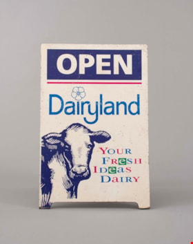
- Description
- Wooden sandwich board advertising Dairyland products. The board consists of two wooden panels that were attached at the top with a piano hinge. The hinge is currently only attached to one panel. The wooden panels are painted white. The paint is chipping in many areas.
- Both panels feature the same information and have an large illustration of a cow's head an front body on the bottom left.
- The two panels are held together on the back with a rusty metal chain.
- Handwritten on the back of one of the panels is "Canada Way Food Market"
- Object History
- Item was used in the Canada Way Food Market owned by Harry Toy between 1975 and the late 2000s. the building sat vacant until sold in 2023.
- Category
- 08. Communication Artifacts
- Classification
- Advertising Media
- Object Term
- Sign, Advertising
- Marks/Labels
- "OPEN / Dairyland / Your / Fresh / Ideas / Dairy"
- Measurements
- Height: 74.5 cm
- Width: 49 cm
- Names
- Canada Way Food Market
- Geographic Access
- Canada Way
- Street Address
- 4692 Canada Way
Images


Radical sentiments
https://search.heritageburnaby.ca/link/archivedescription95098
- Repository
- City of Burnaby Archives
- Date
- April 29, 2020
- Collection/Fonds
- Burnaby Photographic Society fonds
- Description Level
- Item
- Physical Description
- 1 photograph (tiff)
- Scope and Content
- Photograph of a Socialist Alternative "Fight Coronavirus & Fight Capitalism" sign posted to a telephone poll near the BCIT campus.
- Repository
- City of Burnaby Archives
- Date
- April 29, 2020
- Collection/Fonds
- Burnaby Photographic Society fonds
- Physical Description
- 1 photograph (tiff)
- Description Level
- Item
- Record No.
- 623-017
- Access Restriction
- No restrictions
- Reproduction Restriction
- No restrictions
- Accession Number
- 2020-10
- Scope and Content
- Photograph of a Socialist Alternative "Fight Coronavirus & Fight Capitalism" sign posted to a telephone poll near the BCIT campus.
- Media Type
- Photograph
- Photographer
- Damer, Eric
- Notes
- Transcribed title
- Geographic Access
- Willingdon Avenue
- Sanderson Way
- Planning Study Area
- Cascade-Schou Area
Images


Confederation Park playground
https://search.heritageburnaby.ca/link/archivedescription38667
- Repository
- City of Burnaby Archives
- Date
- 1927
- Collection/Fonds
- Burnaby Historical Society fonds
- Description Level
- Item
- Physical Description
- 1 photograph : b&w ; 19 x 23.5 cm
- Scope and Content
- Photograph of the opening of the Confederation Park playground. A group of children and adults can be seen gathered around and using the swings and slides and other playground equipment. A number of homes on Capitol Hill can be seen in the backgound. Confederation Park opened on June 25, 1927.
- Repository
- City of Burnaby Archives
- Date
- 1927
- Collection/Fonds
- Burnaby Historical Society fonds
- Subseries
- North Burnaby Board of Trade subseries
- Physical Description
- 1 photograph : b&w ; 19 x 23.5 cm
- Description Level
- Item
- Record No.
- 476-010
- Access Restriction
- No restrictions
- Reproduction Restriction
- No known restrictions
- Accession Number
- BHS2005-8
- Scope and Content
- Photograph of the opening of the Confederation Park playground. A group of children and adults can be seen gathered around and using the swings and slides and other playground equipment. A number of homes on Capitol Hill can be seen in the backgound. Confederation Park opened on June 25, 1927.
- Subjects
- Geographic Features - Parks
- Recreational Devices - Playgrounds
- Persons - Crowds
- Events - Openings
- Media Type
- Photograph
- Notes
- Title based on contents of photograph
- Geographic Access
- Confederation Park
- Willingdon Avenue
- Street Address
- 250 Willingdon Avenue
- Historic Neighbourhood
- Capitol Hill (Historic Neighbourhood)
- Planning Study Area
- Capitol Hill Area
Images


Confederation Park's new playground
https://search.heritageburnaby.ca/link/museumdescription1088
- Repository
- Burnaby Village Museum
- Date
- 1927
- Collection/Fonds
- Burnaby Village Museum Photograph collection
- Description Level
- Item
- Physical Description
- 1 photograph : sepia ; 19 x 23.5 cm
- Scope and Content
- Photograph of a large gathering of adults and children at Confederation Park for the opening ceremony for the new playground. A man on a pedestal is speaking and a crowd of people are surrounding him. There are six women in front of the gazebo wearing tags attached to the front of their dresses tha…
- Repository
- Burnaby Village Museum
- Collection/Fonds
- Burnaby Village Museum Photograph collection
- Description Level
- Item
- Physical Description
- 1 photograph : sepia ; 19 x 23.5 cm
- Scope and Content
- Photograph of a large gathering of adults and children at Confederation Park for the opening ceremony for the new playground. A man on a pedestal is speaking and a crowd of people are surrounding him. There are six women in front of the gazebo wearing tags attached to the front of their dresses that spell out "CANADA". There are three dogs in the foreground playing, and a Union Jack is flying in the upper right corner of the photograph.
- Subjects
- Recreational Devices - Playgrounds
- Geographic Features - Parks
- Persons - Crowds
- Events - Openings
- Geographic Access
- Confederation Park
- Willingdon Avenue
- Street Address
- 250 Willingdon Avenue
- Accession Code
- HV972.51.15
- Access Restriction
- No restrictions
- Reproduction Restriction
- No known restrictions
- Date
- 1927
- Media Type
- Photograph
- Historic Neighbourhood
- Capitol Hill (Historic Neighbourhood)
- Planning Study Area
- Capitol Hill Area
- Scan Resolution
- 600
- Scan Date
- 2023-04-04
- Photographer
- Charlton and Rathburn
- Notes
- Title based on contents of photograph
- Embossed inscription beneath photograph reads: "Charlton and Rathburn. / Vancouver. B.C."
- Handwritten inscription on verso of photograph reads: "Playground opening / Confederation Park / opening of Playground / Confederation Park / about 1927 / JCD on platform speaking"
- 1 b&w copy print accompanying
Images


Opening of Confederation park playground
https://search.heritageburnaby.ca/link/archivedescription38658
- Repository
- City of Burnaby Archives
- Date
- 1927
- Collection/Fonds
- Burnaby Historical Society fonds
- Description Level
- Item
- Physical Description
- 1 photograph : b&w ; 18.7 x 23 cm
- Scope and Content
- Photograph of a crowd gathered in front of a wooden Gazebo at Confederation park. An unidentified man is seen standing on the step of the structure, addressing the group. A few houses on Capitol Hill are visible in the background. A note on the back of the photograph indicates that it was taken dur…
- Repository
- City of Burnaby Archives
- Date
- 1927
- Collection/Fonds
- Burnaby Historical Society fonds
- Subseries
- North Burnaby Board of Trade subseries
- Physical Description
- 1 photograph : b&w ; 18.7 x 23 cm
- Description Level
- Item
- Record No.
- 476-001
- Access Restriction
- No restrictions
- Reproduction Restriction
- No known restrictions
- Accession Number
- BHS2005-8
- Scope and Content
- Photograph of a crowd gathered in front of a wooden Gazebo at Confederation park. An unidentified man is seen standing on the step of the structure, addressing the group. A few houses on Capitol Hill are visible in the background. A note on the back of the photograph indicates that it was taken during the opening of the Confederation Park playground in 1927.
- Media Type
- Photograph
- Notes
- Title based on caption accompanying the photograph
- Geographic Access
- Confederation Park
- Willingdon Avenue
- Street Address
- 250 Willingdon Avenue
- Historic Neighbourhood
- Capitol Hill (Historic Neighbourhood)
- Planning Study Area
- Capitol Hill Area
Images


Tommy Douglas at Confederation Park
https://search.heritageburnaby.ca/link/archivedescription51470
- Repository
- City of Burnaby Archives
- Date
- 1968
- Collection/Fonds
- Harold H. Johnston fonds
- Description Level
- Item
- Physical Description
- 1 photograph (jpeg) : b&w
- Scope and Content
- Photograph of a crowd of people gathered to listen to Tommy Douglas deliver a speech at Confederation Park. A few people in the audience are holding signs that read "Re-elect Douglas." Tommy Douglas served as the MP for Burnaby-Coquitlam from 1962 to 1968. He went on to become the 7th Premier of S…
- Repository
- City of Burnaby Archives
- Date
- 1968
- Collection/Fonds
- Harold H. Johnston fonds
- Physical Description
- 1 photograph (jpeg) : b&w
- Description Level
- Item
- Record No.
- 483-071
- Access Restriction
- No restrictions
- Reproduction Restriction
- No reproduction permitted
- Accession Number
- 2008-08
- Scope and Content
- Photograph of a crowd of people gathered to listen to Tommy Douglas deliver a speech at Confederation Park. A few people in the audience are holding signs that read "Re-elect Douglas." Tommy Douglas served as the MP for Burnaby-Coquitlam from 1962 to 1968. He went on to become the 7th Premier of Saskatchewan.
- Subjects
- Persons - Crowds
- Officials - Premiers
- Officials - Alderman and Councillors
- Advertising Medium - Signs and Signboards
- Names
- Douglas, Tommy
- Media Type
- Photograph
- Photographer
- Johnston, Harold H.
- Notes
- Title based on contents of photograph
- Geographic Access
- Willingdon Avenue
- Street Address
- 250 Willingdon Avenue
- Historic Neighbourhood
- Capitol Hill (Historic Neighbourhood)
- Planning Study Area
- Capitol Hill Area
Images
