![4006 Douglas Road, [1960] (date of original), copied 1991 thumbnail](/media/hpo/_Data/_Archives_Images/_Unrestricted/370/370-516.jpg?width=280)
4006 Douglas Road
https://search.heritageburnaby.ca/link/archivedescription37928
- Repository
- City of Burnaby Archives
- Date
- [1960] (date of original), copied 1991
- Collection/Fonds
- Burnaby Historical Society fonds
- Description Level
- Item
- Physical Description
- 1 photograph : b&w ; 3.1 x 3.1 cm print on contact sheet 20.7 x 26.5 cm
- Scope and Content
- Photograph of 4006 Douglas Road (old numbering) in the snow. The house was located near Douglas Road and Gilpin Street.
- Repository
- City of Burnaby Archives
- Date
- [1960] (date of original), copied 1991
- Collection/Fonds
- Burnaby Historical Society fonds
- Subseries
- Burnaby Image Bank subseries
- Physical Description
- 1 photograph : b&w ; 3.1 x 3.1 cm print on contact sheet 20.7 x 26.5 cm
- Description Level
- Item
- Record No.
- 370-516
- Access Restriction
- No restrictions
- Reproduction Restriction
- No restrictions
- Accession Number
- BHS1999-03
- Scope and Content
- Photograph of 4006 Douglas Road (old numbering) in the snow. The house was located near Douglas Road and Gilpin Street.
- Subjects
- Natural Phenomena - Snow
- Media Type
- Photograph
- Notes
- Title based on contents of photograph
- 1 b&w copy negative accompanying
- Negative has a pink cast
- Geographic Access
- Gilpin Street
- Historic Neighbourhood
- Burnaby Lake (Historic Neighbourhood)
- Planning Study Area
- Douglas-Gilpin Area
Images
![4006 Douglas Road, [1960] (date of original), copied 1991 thumbnail](/media/hpo/_Data/_Archives_Images/_Unrestricted/370/370-516.jpg)
5118 Douglas Road landscaping plan
https://search.heritageburnaby.ca/link/archivedescription91895
- Repository
- City of Burnaby Archives
- Date
- ca. 1931
- Collection/Fonds
- Small family fonds
- Description Level
- Item
- Physical Description
- 1 technical drawing : ink and pencil on paper ; 61 cm x 49 cm
- Scope and Content
- Item is a landscaping plan for the property at 5118 Douglas Street, with individual trees plotted and their species identified.
- Repository
- City of Burnaby Archives
- Date
- ca. 1931
- Collection/Fonds
- Small family fonds
- Physical Description
- 1 technical drawing : ink and pencil on paper ; 61 cm x 49 cm
- Material Details
- Scale : 1/8" = 1'
- Description Level
- Item
- Record No.
- 60633
- Access Restriction
- Open access
- Accession Number
- 2017-01
- Scope and Content
- Item is a landscaping plan for the property at 5118 Douglas Street, with individual trees plotted and their species identified.
- Media Type
- Technical Drawing
![Aerial photograph of Douglas Road and Sperling Avenue, [1938] thumbnail](/media/hpo/_Data/_BVM_Images/1990/199200470001.jpg?width=280)
Aerial photograph of Douglas Road and Sperling Avenue
https://search.heritageburnaby.ca/link/museumdescription1165
- Repository
- Burnaby Village Museum
- Date
- [1938]
- Collection/Fonds
- Burnaby Village Museum Photograph collection
- Description Level
- Item
- Physical Description
- 1 photograph : b&w ; 19 x 24 cm
- Scope and Content
- Aerial photograph of the area surrounding Douglas Road and Sperling Avenue.
- Repository
- Burnaby Village Museum
- Collection/Fonds
- Burnaby Village Museum Photograph collection
- Description Level
- Item
- Physical Description
- 1 photograph : b&w ; 19 x 24 cm
- Scope and Content
- Aerial photograph of the area surrounding Douglas Road and Sperling Avenue.
- Subjects
- Aerial Photographs
- Geographic Access
- Douglas Road
- Sperling Avenue
- Accession Code
- BV992.47.1
- Access Restriction
- No restrictions
- Date
- [1938]
- Media Type
- Photograph
- Historic Neighbourhood
- Burnaby Lake (Historic Neighbourhood)
- Planning Study Area
- Morley-Buckingham Area
- Scan Resolution
- 600
- Scan Date
- 01-Jun-09
- Scale
- 100
- Notes
- Title based on contents of photograph
- Notes on verso of photograph read: "Burnaby Image Bank #532" and "DOUGLAS ROAD AND SPERLING c. 1938"
- Stamp on verso of photograph reads: "Copyright Simon Fraser/ University Archives"
Images
![Aerial photograph of Douglas Road and Sperling Avenue, [1938] thumbnail](/media/hpo/_Data/_BVM_Images/1990/199200470001.jpg)
![Back yard of 5118 Douglas Road, [1951] thumbnail](/media/hpo/_Data/_Archives_Images/_Unrestricted/600/620-019.jpg?width=280)
Back yard of 5118 Douglas Road
https://search.heritageburnaby.ca/link/archivedescription91838
- Repository
- City of Burnaby Archives
- Date
- [1951]
- Collection/Fonds
- Small family fonds
- Description Level
- Item
- Physical Description
- 1 photograph : b&w ; 7 cm x 11.5 cm
- Scope and Content
- Photograph of the backyard and screened summer house at 5118 Douglas Road after a snowfall. The summer house was used by the Roberts children for sleeping outdoors in the summertime and by the Small children as a playhouse. It rotted and collapsed in the 1960s, likely following the "Big Snow" of …
- Repository
- City of Burnaby Archives
- Date
- [1951]
- Collection/Fonds
- Small family fonds
- Physical Description
- 1 photograph : b&w ; 7 cm x 11.5 cm
- Description Level
- Item
- Record No.
- 620-019
- Access Restriction
- No restrictions
- Reproduction Restriction
- No reproduction permitted
- Accession Number
- 2017-01
- Scope and Content
- Photograph of the backyard and screened summer house at 5118 Douglas Road after a snowfall. The summer house was used by the Roberts children for sleeping outdoors in the summertime and by the Small children as a playhouse. It rotted and collapsed in the 1960s, likely following the "Big Snow" of December 1964.
- Media Type
- Photograph
- Notes
- Transcribed title
- Title transcribed from donor's notes
- Note in black ink on verso of photograph reads: "Summer House in the Snow / Burnaby - 1951?"
- Note in blue ink on verson of photograph reads: "P.19"
- 5118 Douglas Road renumbered to 3131 Douglas Road in 1958 and to 5538 Dominion Street in 1970 or 1971
- Street Address
- 3131 Douglas Road
- 5118 Douglas Road
- 5538 Dominion Street
- Historic Neighbourhood
- Burnaby Lake (Historic Neighbourhood)
- Planning Study Area
- Ardingley-Sprott Area
Images
![Back yard of 5118 Douglas Road, [1951] thumbnail](/media/hpo/_Data/_Archives_Images/_Unrestricted/600/620-019.jpg)
![Child on Douglas Road sidewalk, [1915 or 1916] (date of original), copied 1991 thumbnail](/media/hpo/_Data/_Archives_Images/_Unrestricted/370/370-771.jpg?width=280)
Child on Douglas Road sidewalk
https://search.heritageburnaby.ca/link/archivedescription38184
- Repository
- City of Burnaby Archives
- Date
- [1915 or 1916] (date of original), copied 1991
- Collection/Fonds
- Burnaby Historical Society fonds
- Description Level
- Item
- Physical Description
- 1 photograph : b&w ; 4.5 x 3.4 cm print on contact sheet 20.6 x 26.5 cm
- Scope and Content
- Photograph of a child in a baby carriage on a board sidewalk on Douglas Road.
- Repository
- City of Burnaby Archives
- Date
- [1915 or 1916] (date of original), copied 1991
- Collection/Fonds
- Burnaby Historical Society fonds
- Subseries
- Burnaby Image Bank subseries
- Physical Description
- 1 photograph : b&w ; 4.5 x 3.4 cm print on contact sheet 20.6 x 26.5 cm
- Description Level
- Item
- Record No.
- 370-771
- Access Restriction
- No restrictions
- Reproduction Restriction
- No known restrictions
- Accession Number
- BHS1999-03
- Scope and Content
- Photograph of a child in a baby carriage on a board sidewalk on Douglas Road.
- Media Type
- Photograph
- Notes
- Title based on contents of photograph
- 1 b&w copy negative accompanying
- Negative has a pink cast
- Geographic Access
- Douglas Road
- Historic Neighbourhood
- Vancouver Heights (Historic Neighbourhood)
- Planning Study Area
- Willingdon Heights Area
Images
![Child on Douglas Road sidewalk, [1915 or 1916] (date of original), copied 1991 thumbnail](/media/hpo/_Data/_Archives_Images/_Unrestricted/370/370-771.jpg)
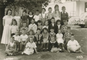
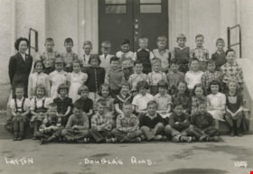
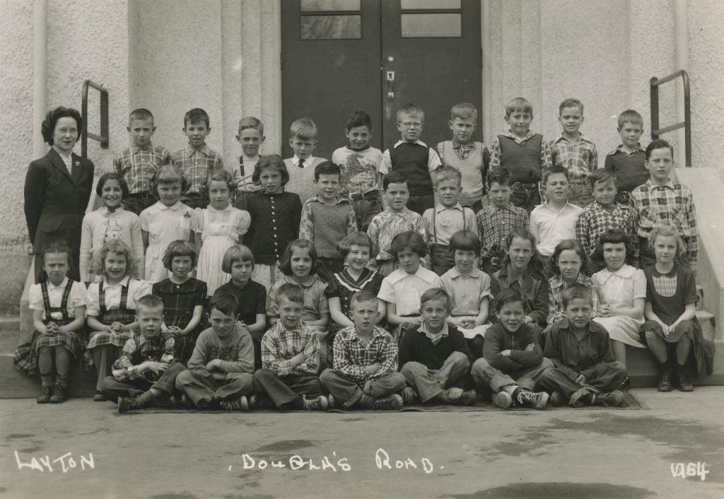
Class at Douglas Road School
https://search.heritageburnaby.ca/link/archivedescription36052
- Repository
- City of Burnaby Archives
- Date
- 1953
- Collection/Fonds
- Burnaby Historical Society fonds
- Description Level
- Item
- Physical Description
- 1 photograph : b&w ; 11.5 x 16.5 cm
- Scope and Content
- Photograph of a class at Douglas Road School, standing and sitting in rows with their teacher Greta Martin (Nee Beck) standing on the left.
- Repository
- City of Burnaby Archives
- Date
- 1953
- Collection/Fonds
- Burnaby Historical Society fonds
- Subseries
- Grace Dickie subseries
- Physical Description
- 1 photograph : b&w ; 11.5 x 16.5 cm
- Material Details
- Photographer wrote their name and the date on the negative, making both white on the photograph
- Description Level
- Item
- Record No.
- 215-010
- Access Restriction
- No restrictions
- Reproduction Restriction
- Reproduce for fair dealing purposes only
- Accession Number
- BHS1989-03
- Scope and Content
- Photograph of a class at Douglas Road School, standing and sitting in rows with their teacher Greta Martin (Nee Beck) standing on the left.
- Subjects
- Occupations - Teachers
- Media Type
- Photograph
- Notes
- Title based on contents of photograph
- Photographer identified as "Layton"
- Geographic Access
- Canada Way
- Street Address
- 4861 Canada Way
- Historic Neighbourhood
- Burnaby Lake (Historic Neighbourhood)
- Planning Study Area
- Douglas-Gilpin Area
Images

![Clearing Douglas Road, [190-?] (date of original), copied 1977 thumbnail](/media/hpo/_Data/_BVM_Images/1977/1977_0099_0002_001.jpg?width=280)
Clearing Douglas Road
https://search.heritageburnaby.ca/link/museumdescription560
- Repository
- Burnaby Village Museum
- Date
- [190-?] (date of original), copied 1977
- Collection/Fonds
- Burnaby Village Museum Photograph collection
- Description Level
- Item
- Physical Description
- 1 photograph : b&w ; 20.2 x 25.2 cm print
- Scope and Content
- Photograph of men in work clothes clearing Doulgas Road. A group of men to the right side of the photograph have shovels in their hands and are clearing rocks from the road. There is a small girl in a blouse and skirt standing beside two horses pulling a cart. Behind her is a group of men in wor…
- Repository
- Burnaby Village Museum
- Collection/Fonds
- Burnaby Village Museum Photograph collection
- Description Level
- Item
- Physical Description
- 1 photograph : b&w ; 20.2 x 25.2 cm print
- Scope and Content
- Photograph of men in work clothes clearing Doulgas Road. A group of men to the right side of the photograph have shovels in their hands and are clearing rocks from the road. There is a small girl in a blouse and skirt standing beside two horses pulling a cart. Behind her is a group of men in work clothes as well. There is fenced land to the right of the photograph, and electric power poles and trees line both sides of the road. The accession register and inscription on the photograph identify this as Douglas Road (later renamed in part Canada Way). An annotation on the back of the photo reads: "Working on Douglas Road on hill above Burnaby Lake. No Date."
- Geographic Access
- Douglas Road
- Canada Way
- Accession Code
- HV977.99.2
- Access Restriction
- No restrictions
- Reproduction Restriction
- May be restricted by third party rights
- Date
- [190-?] (date of original), copied 1977
- Media Type
- Photograph
- Historic Neighbourhood
- Burnaby Lake (Historic Neighbourhood)
- Scan Resolution
- 600
- Scan Date
- 2023-07-11
- Notes
- Title based on contents of photograph
Images
![Clearing Douglas Road, [190-?] (date of original), copied 1977 thumbnail](/media/hpo/_Data/_BVM_Images/1977/1977_0099_0002_001.jpg)

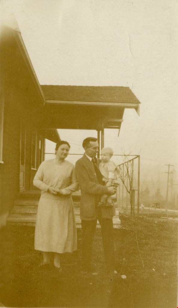
Close up of front of Roberts' house 5118 Douglas Road
https://search.heritageburnaby.ca/link/archivedescription91836
- Repository
- City of Burnaby Archives
- Date
- 1927
- Collection/Fonds
- Small family fonds
- Description Level
- Item
- Physical Description
- 1 photograph : sepia ; 10 cm x 6 cm
- Scope and Content
- Photograph of John W. and Mary Roberts (pregnant with son Roland) and their son Edward Roberts standing in front of their house at 5118 Douglas Road. The front steps and porch of the house are complete, but the pillars and sidewalk are not yet in place. In the background is the framework for nett…
- Repository
- City of Burnaby Archives
- Date
- 1927
- Collection/Fonds
- Small family fonds
- Physical Description
- 1 photograph : sepia ; 10 cm x 6 cm
- Description Level
- Item
- Record No.
- 620-017
- Access Restriction
- No restrictions
- Reproduction Restriction
- No known restrictions
- Accession Number
- 2017-01
- Scope and Content
- Photograph of John W. and Mary Roberts (pregnant with son Roland) and their son Edward Roberts standing in front of their house at 5118 Douglas Road. The front steps and porch of the house are complete, but the pillars and sidewalk are not yet in place. In the background is the framework for netting around the property's tennis court. To the right is Douglas Road, where the Roberts' mailbox and a car are visible in the distance.
- Media Type
- Photograph
- Notes
- Transcribed title
- Title transcribed from donor's notes
- Note in black ink on verso of photograph reads: "Aug, 1927 / Mother, father and Teddy / Please return"
- Note in black ink on verso of photograph reads: "How's this John?"
- Stamp on verso of photograph read: "56"
- Note in blue ink on verso of photograph reads: "P.17"
- 5118 Douglas Road renumbered to 3131 Douglas Road in 1958 and to 5538 Dominion Street in 1970 or 1971
- Street Address
- 3131 Douglas Road
- 5118 Douglas Road
- 5538 Dominion Street
- Historic Neighbourhood
- Burnaby Lake (Historic Neighbourhood)
- Planning Study Area
- Ardingley-Sprott Area
Images
![Close up of front of Robert's house 5118 Douglas Road, [between 1931 and 1932] thumbnail](/media/hpo/_Data/_Archives_Images/_Unrestricted/600/620-018.jpg?width=280)
Close up of front of Robert's house 5118 Douglas Road
https://search.heritageburnaby.ca/link/archivedescription91837
- Repository
- City of Burnaby Archives
- Date
- [between 1931 and 1932]
- Collection/Fonds
- Small family fonds
- Description Level
- Item
- Physical Description
- 1 photograph : b&w ; 8.5 cm x 9.5 cm
- Scope and Content
- Photograph of the Roberts children: John A., Edward (Ted) and Roland in front of the Roberts' house at 5118 Douglas Road. Ted and Roland sit in a toboggan while John stands behind them, holding the toboggan's strings. In the background, a large swing frame is attached to the cedar tree. The grou…
- Repository
- City of Burnaby Archives
- Date
- [between 1931 and 1932]
- Collection/Fonds
- Small family fonds
- Physical Description
- 1 photograph : b&w ; 8.5 cm x 9.5 cm
- Description Level
- Item
- Record No.
- 620-018
- Access Restriction
- No restrictions
- Reproduction Restriction
- No restrictions
- Accession Number
- 2017-01
- Scope and Content
- Photograph of the Roberts children: John A., Edward (Ted) and Roland in front of the Roberts' house at 5118 Douglas Road. Ted and Roland sit in a toboggan while John stands behind them, holding the toboggan's strings. In the background, a large swing frame is attached to the cedar tree. The ground is lightly covered with snow.
- Subjects
- Buildings - Residential - Houses
- Recreational Activities
- Natural Phenomena - Snow
- Persons - Children
- Media Type
- Photograph
- Notes
- Transcribed title
- Title transcribed from donor's notes
- Note in blue ink on verso of photograph reads: "John, Ted (Edward), and Roland Roberts / (winter 1931-32?)"
- Note in blue ink on verso of photograph reads: "Maybe x 1932?"
- Stamp on verso of photograph reads: "331"
- Note in blue ink on verso of photograph reads: "P.18"
- 5118 Douglas Road renumbered to 3131 Douglas Road in 1958 and to 5538 Dominion Street in 1970 or 1971
- Street Address
- 3131 Douglas Road
- 5118 Douglas Road
- 5538 Dominion Street
- Historic Neighbourhood
- Burnaby Lake (Historic Neighbourhood)
- Planning Study Area
- Ardingley-Sprott Area
Images
![Close up of front of Robert's house 5118 Douglas Road, [between 1931 and 1932] thumbnail](/media/hpo/_Data/_Archives_Images/_Unrestricted/600/620-018.jpg)
![Creating planters at Douglas Road School, [2004] thumbnail](/media/hpo/_Data/_Archives_Images/_Unrestricted/535/535-2060.jpg?width=280)
Creating planters at Douglas Road School
https://search.heritageburnaby.ca/link/archivedescription96390
- Repository
- City of Burnaby Archives
- Date
- [2004]
- Collection/Fonds
- Burnaby NewsLeader photograph collection
- Description Level
- Item
- Physical Description
- 1 photograph (tiff) : col.
- Scope and Content
- Photograph of young student Carlos Pineda and Debbie Hamilton, an employee at GardenWorks, planting plants in a classroom at Douglas Road Elementary School.
- Repository
- City of Burnaby Archives
- Date
- [2004]
- Collection/Fonds
- Burnaby NewsLeader photograph collection
- Physical Description
- 1 photograph (tiff) : col.
- Description Level
- Item
- Record No.
- 535-2060
- Access Restriction
- No restrictions
- Reproduction Restriction
- No restrictions
- Accession Number
- 2018-12
- Scope and Content
- Photograph of young student Carlos Pineda and Debbie Hamilton, an employee at GardenWorks, planting plants in a classroom at Douglas Road Elementary School.
- Subjects
- Plants
- Persons - Students
- Buildings - Schools
- Names
- Douglas Road School
- Media Type
- Photograph
- Photographer
- Bartel, Mario
- Notes
- Title based on caption
- Collected by editorial for use in a March 2004 issue of the Burnaby NewsLeader
- Caption from metadata: "Carlos Pineda gets a little help with creating a planter from Debbie Hamilton, from Garden Works. Kindergarten and Grade 1/2 students at Douglas Road Elementary are learning how to design and create the planters for the Garden Glory Show, at Metropolis at Metrotown."
- Geographic Access
- Canada Way
- Street Address
- 4861 Canada Way
- Historic Neighbourhood
- Burnaby Lake (Historic Neighbourhood)
- Planning Study Area
- Douglas-Gilpin Area
Images
![Creating planters at Douglas Road School, [2004] thumbnail](/media/hpo/_Data/_Archives_Images/_Unrestricted/535/535-2060.jpg)
![Crowd gathered at Sperling Avenue and Douglas Road, [1905] thumbnail](/media/hpo/_Data/_Archives_Images/_Unrestricted/477/477-176.jpg?width=280)
Crowd gathered at Sperling Avenue and Douglas Road
https://search.heritageburnaby.ca/link/archivedescription38857
- Repository
- City of Burnaby Archives
- Date
- [1905]
- Collection/Fonds
- Peers Family and Hill Family fonds
- Description Level
- Item
- Physical Description
- 1 photograph : sepia ; 6 x 10.5 cm on page 14 x 17.5 cm (pasted in album)
- Scope and Content
- Photograph of a crowd of people gathered near the corner of Sperling Avenue and Douglas Road (later Canada Way). A sign in the background reads: "Burnaby By the Lakes Business Sites."
- Repository
- City of Burnaby Archives
- Date
- [1905]
- Collection/Fonds
- Peers Family and Hill Family fonds
- Physical Description
- 1 photograph : sepia ; 6 x 10.5 cm on page 14 x 17.5 cm (pasted in album)
- Description Level
- Item
- Record No.
- 477-176
- Access Restriction
- No restrictions
- Reproduction Restriction
- No known restrictions
- Accession Number
- 2007-12
- Scope and Content
- Photograph of a crowd of people gathered near the corner of Sperling Avenue and Douglas Road (later Canada Way). A sign in the background reads: "Burnaby By the Lakes Business Sites."
- Media Type
- Photograph
- Notes
- Title based on contents of photograph
- Geographic Access
- Douglas Road
- Sperling Avenue
- Canada Way
- Historic Neighbourhood
- Burnaby Lake (Historic Neighbourhood)
- Planning Study Area
- Morley-Buckingham Area
Images
![Crowd gathered at Sperling Avenue and Douglas Road, [1905] thumbnail](/media/hpo/_Data/_Archives_Images/_Unrestricted/477/477-176.jpg)
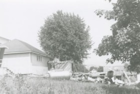
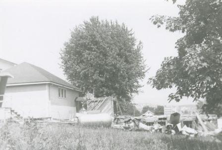
Demolition debris at Douglas Road School
https://search.heritageburnaby.ca/link/archivedescription38645
- Repository
- City of Burnaby Archives
- Date
- 1956
- Collection/Fonds
- Burnaby Historical Society fonds
- Description Level
- Item
- Physical Description
- 1 photograph : b&w ; 10 x 15 cm
- Scope and Content
- Photograph of demolition debris outside the Douglas Road School.
- Repository
- City of Burnaby Archives
- Date
- 1956
- Collection/Fonds
- Burnaby Historical Society fonds
- Subseries
- Douglas Road School subseries
- Physical Description
- 1 photograph : b&w ; 10 x 15 cm
- Description Level
- Item
- Record No.
- 471-006
- Access Restriction
- No restrictions
- Reproduction Restriction
- Reproduce for fair dealing purposes only
- Accession Number
- BHS2005-3
- Scope and Content
- Photograph of demolition debris outside the Douglas Road School.
- Subjects
- Buildings - Schools
- Construction
- Names
- Douglas Road School
- Media Type
- Photograph
- Photographer
- Gordon, Ethel
- Notes
- Title based on contents of photograph
- Geographic Access
- Canada Way
- Street Address
- 4861 Canada Way
- Historic Neighbourhood
- Burnaby Lake (Historic Neighbourhood)
- Planning Study Area
- Douglas-Gilpin Area
Images

Douglas Road
https://search.heritageburnaby.ca/link/archivedescription34056
- Repository
- City of Burnaby Archives
- Date
- 1904
- Collection/Fonds
- Burnaby Historical Society fonds
- Description Level
- Item
- Physical Description
- 1 photograph : b&w ; 5.5 x 8.2 cm
- Scope and Content
- Photograph of Douglas Road covered with snow.
- Repository
- City of Burnaby Archives
- Date
- 1904
- Collection/Fonds
- Burnaby Historical Society fonds
- Subseries
- Photographs subseries
- Physical Description
- 1 photograph : b&w ; 5.5 x 8.2 cm
- Description Level
- Item
- Record No.
- 002-004
- Access Restriction
- No restrictions
- Reproduction Restriction
- No known restrictions
- Accession Number
- BHS2007-04
- Scope and Content
- Photograph of Douglas Road covered with snow.
- Media Type
- Photograph
- Notes
- Title based on contents of photograph
- Photograph has been cropped
- Geographic Access
- Douglas Road
Images


Douglas Road
https://search.heritageburnaby.ca/link/archivedescription34057
- Repository
- City of Burnaby Archives
- Date
- 1907
- Collection/Fonds
- Burnaby Historical Society fonds
- Description Level
- Item
- Physical Description
- 1 photograph : b&w ; 7.8 x 5.3 cm
- Scope and Content
- Photograph of Douglas Road covered with snow.
- Repository
- City of Burnaby Archives
- Date
- 1907
- Collection/Fonds
- Burnaby Historical Society fonds
- Subseries
- Photographs subseries
- Physical Description
- 1 photograph : b&w ; 7.8 x 5.3 cm
- Description Level
- Item
- Record No.
- 002-005
- Access Restriction
- No restrictions
- Reproduction Restriction
- No known restrictions
- Accession Number
- BHS2007-04
- Scope and Content
- Photograph of Douglas Road covered with snow.
- Media Type
- Photograph
- Notes
- Title based on contents of photograph
- Photograph has been cropped
- Geographic Access
- Douglas Road
Images


Douglas Road
https://search.heritageburnaby.ca/link/archivedescription35897
- Repository
- City of Burnaby Archives
- Date
- 1895 (date of original), copied 1986
- Collection/Fonds
- Burnaby Historical Society fonds
- Description Level
- Item
- Physical Description
- 1 photograph : b&w ; 12.7 x 17.8 cm print
- Scope and Content
- Photograph of Douglas Road at Haszard Hill.
- Repository
- City of Burnaby Archives
- Date
- 1895 (date of original), copied 1986
- Collection/Fonds
- Burnaby Historical Society fonds
- Subseries
- Pioneer Tales subseries
- Physical Description
- 1 photograph : b&w ; 12.7 x 17.8 cm print
- Description Level
- Item
- Record No.
- 204-756
- Access Restriction
- No restrictions
- Reproduction Restriction
- No known restrictions
- Accession Number
- BHS1988-03
- Scope and Content
- Photograph of Douglas Road at Haszard Hill.
- Subjects
- Geographic Features - Roads
- Media Type
- Photograph
- Notes
- Title based on contents of photograph
- Type note under photograph reads, "Douglas Road, 1895. Deviation from old road, seen on right at, then, Haszard Hill, now Rayside Ave, looking eastward up the hill."
- Geographic Access
- Douglas Road
- Historic Neighbourhood
- Burnaby Lake (Historic Neighbourhood)
- Planning Study Area
- Morley-Buckingham Area
Images

Douglas Road
https://search.heritageburnaby.ca/link/archivedescription36053
- Repository
- City of Burnaby Archives
- Date
- 1964
- Collection/Fonds
- Burnaby Historical Society fonds
- Description Level
- Item
- Physical Description
- 1 photograph : b&w ; 11.5 x 16 cm
- Scope and Content
- Photograph of Marietta Ketchum (far left) and her class at Douglas Road School lined up in rows on the steps of the school.
- Repository
- City of Burnaby Archives
- Date
- 1964
- Collection/Fonds
- Burnaby Historical Society fonds
- Subseries
- Grace Dickie subseries
- Physical Description
- 1 photograph : b&w ; 11.5 x 16 cm
- Material Details
- Photographer wrote their name and the date on the negative, making both white on the photograph
- Description Level
- Item
- Record No.
- 215-011
- Access Restriction
- No restrictions
- Reproduction Restriction
- Reproduce for fair dealing purposes only
- Accession Number
- BHS1989-03
- Scope and Content
- Photograph of Marietta Ketchum (far left) and her class at Douglas Road School lined up in rows on the steps of the school.
- Subjects
- Occupations - Teachers
- Media Type
- Photograph
- Notes
- Photographer identified as "Layton"
- Geographic Access
- Canada Way
- Street Address
- 4861 Canada Way
- Historic Neighbourhood
- Burnaby Lake (Historic Neighbourhood)
- Planning Study Area
- Douglas-Gilpin Area
Images

Douglas Road
https://search.heritageburnaby.ca/link/archivedescription39522
- Repository
- City of Burnaby Archives
- Date
- 1890
- Collection/Fonds
- Peers Family and Hill Family fonds
- Description Level
- Item
- Physical Description
- 1 photograph : b&w ; 10 x 11 cm on page 21.5 x 28 cm (pasted in album)
- Scope and Content
- Photograph of a trail through the woods that is labelled "Douglas Road."
- Repository
- City of Burnaby Archives
- Date
- 1890
- Collection/Fonds
- Peers Family and Hill Family fonds
- Physical Description
- 1 photograph : b&w ; 10 x 11 cm on page 21.5 x 28 cm (pasted in album)
- Description Level
- Item
- Record No.
- 477-841
- Access Restriction
- No restrictions
- Reproduction Restriction
- No known restrictions
- Accession Number
- 2007-12
- Scope and Content
- Photograph of a trail through the woods that is labelled "Douglas Road."
- Subjects
- Geographic Features - Trails
- Media Type
- Photograph
- Notes
- Title based on caption accompanying photograph
- Geographic Access
- Douglas Road
- Historic Neighbourhood
- Burnaby Lake (Historic Neighbourhood)
Images

![Douglas Road, [1897] (date of original), copied 1978 thumbnail](/media/hpo/_Data/_BVM_Images/1978/1978_0001_0001_001.jpg?width=280)
Douglas Road
https://search.heritageburnaby.ca/link/museumdescription447
- Repository
- Burnaby Village Museum
- Date
- [1897] (date of original), copied 1978
- Collection/Fonds
- Burnaby Village Museum Photograph collection
- Description Level
- Item
- Physical Description
- 1 photograph : b&w ; 20.2 x 25.2 cm print
- Scope and Content
- Photograph of Douglas Road (later renamed in part Canada Way), near Stanley Street. To the right is the Sprott family property, where a few wooden buildings are visible in the cleared area. Charles Sprott, head of the Sprott family, was an important Burnaby politician who was continuously elected t…
- Repository
- Burnaby Village Museum
- Collection/Fonds
- Burnaby Village Museum Photograph collection
- Description Level
- Item
- Physical Description
- 1 photograph : b&w ; 20.2 x 25.2 cm print
- Scope and Content
- Photograph of Douglas Road (later renamed in part Canada Way), near Stanley Street. To the right is the Sprott family property, where a few wooden buildings are visible in the cleared area. Charles Sprott, head of the Sprott family, was an important Burnaby politician who was continuously elected to serve in the municiality as councillor from 1895 to 1903 and as Reeve from 1904 to 1905.
- Subjects
- Geographic Features - Roads
- Land Clearing
- Geographic Access
- Douglas Road
- Canada Way
- Stanley Street
- Accession Code
- HV978.1.1
- Access Restriction
- No restrictions
- Reproduction Restriction
- No known restrictions
- Date
- [1897] (date of original), copied 1978
- Media Type
- Photograph
- Historic Neighbourhood
- Burnaby Lake (Historic Neighbourhood)
- Planning Study Area
- Lakeview-Mayfield Area
- Scan Resolution
- 600
- Scan Date
- 2023-07-25
- Notes
- Title based on contents of photograph
Images
![Douglas Road, [1897] (date of original), copied 1978 thumbnail](/media/hpo/_Data/_BVM_Images/1978/1978_0001_0001_001.jpg)
![Douglas Road back lane, [192-] (date of original), copied 1991 thumbnail](/media/hpo/_Data/_Archives_Images/_Unrestricted/370/370-525.jpg?width=280)
Douglas Road back lane
https://search.heritageburnaby.ca/link/archivedescription37938
- Repository
- City of Burnaby Archives
- Date
- [192-] (date of original), copied 1991
- Collection/Fonds
- Burnaby Historical Society fonds
- Description Level
- Item
- Physical Description
- 1 photograph : b&w ; 4.1 x 2.4 cm print on contact sheet 20.5 x 26.7 cm
- Scope and Content
- Photograph of the back lane of the 4000 block of Douglas Road (old numbering) at Gilpin Street.
- Repository
- City of Burnaby Archives
- Date
- [192-] (date of original), copied 1991
- Collection/Fonds
- Burnaby Historical Society fonds
- Subseries
- Burnaby Image Bank subseries
- Physical Description
- 1 photograph : b&w ; 4.1 x 2.4 cm print on contact sheet 20.5 x 26.7 cm
- Description Level
- Item
- Record No.
- 370-525
- Access Restriction
- No restrictions
- Reproduction Restriction
- No known restrictions
- Accession Number
- BHS1999-03
- Scope and Content
- Photograph of the back lane of the 4000 block of Douglas Road (old numbering) at Gilpin Street.
- Subjects
- Geographic Features - Lanes
- Media Type
- Photograph
- Notes
- Title based on contents of photograph
- 1 b&w copy negative accompanying
- Negative has a pink cast
- Geographic Access
- Douglas Road
- Gilpin Street
- Historic Neighbourhood
- Burnaby Lake (Historic Neighbourhood)
- Planning Study Area
- Douglas-Gilpin Area
Images
![Douglas Road back lane, [192-] (date of original), copied 1991 thumbnail](/media/hpo/_Data/_Archives_Images/_Unrestricted/370/370-525.jpg)
![Douglas Road, Burnaby, [1908] thumbnail](/media/hpo/_Data/_Archives_Images/_Unrestricted/371/449-009.jpg?width=280)
Douglas Road, Burnaby
https://search.heritageburnaby.ca/link/archivedescription38514
- Repository
- City of Burnaby Archives
- Date
- [1908]
- Collection/Fonds
- Burnaby Historical Society fonds
- Description Level
- Item
- Physical Description
- 1 photograph : sepia postcard ; 8.8 x 14 cm
- Scope and Content
- Photographic postcard taken looking northwest along Douglas Road (now Canada Way) near Stanley Street. Two unidentified people are standing next to a wooden fence running alongside the road (above Lubbock's Creek) and a number of houses (including the Sprott house) are visible in the background. To…
- Repository
- City of Burnaby Archives
- Date
- [1908]
- Collection/Fonds
- Burnaby Historical Society fonds
- Subseries
- Photographs subseries
- Physical Description
- 1 photograph : sepia postcard ; 8.8 x 14 cm
- Description Level
- Item
- Record No.
- 449-009
- Access Restriction
- No restrictions
- Reproduction Restriction
- No known restrictions
- Accession Number
- BHS2007-04
- Scope and Content
- Photographic postcard taken looking northwest along Douglas Road (now Canada Way) near Stanley Street. Two unidentified people are standing next to a wooden fence running alongside the road (above Lubbock's Creek) and a number of houses (including the Sprott house) are visible in the background. To the right is Burnaby Lake. Stamped at the top of the postcard is "Douglas Road, Burnaby / New Westminster BC."
- Subjects
- Geographic Features - Lakes and Ponds
- Documentary Artifacts - Postcards
- Geographic Features - Roads
- Media Type
- Photograph
- Geographic Access
- Douglas Road
- Stanley Street
- Canada Way
- Deer Lake
- Historic Neighbourhood
- Burnaby Lake (Historic Neighbourhood)
- Planning Study Area
- Lakeview-Mayfield Area
Images
![Douglas Road, Burnaby, [1908] thumbnail](/media/hpo/_Data/_Archives_Images/_Unrestricted/371/449-009.jpg)