Narrow Results By
Decade
- 2020s 11
- 2010s 12
- 2000s 12
- 1990s 65
- 1980s 71
- 1970s 90
- 1960s 72
- 1950s 69
- 1940s 89
- 1930s 93
- 1920s 63
- 1910s 46
- 1900s 22
- 1890s 18
- 1880s 7
- 1870s 5
- 1860s 4
- 1850s 3
- 1840s 1
- 1830s 1
- 1820s 1
- 1810s 2
- 1800s 2
- 1790s 2
- 1780s 2
- 1770s 2
- 1760s 2
- 1750s 2
- 1740s 2
- 1730s 2
- 1720s 2
- 1710s 2
- 1700s 2
- 1690s 2
- 1680s 2
- 1670s 1
- 1660s 1
- 1650s 1
- 1640s 1
- 1630s 1
- 1620s 1
- 1610s 1
- 1600s 1
- 1590s 1
- 1580s 1
- 1570s 1
- 1560s 1
- 1550s 1
- 1540s 1
- 1530s 1
- 1520s 1
- 1510s 1
- 1500s 1
- 1490s 1
- 1480s 1
Creator
- Binks, James 2
- Burnaby Village Museum 11
- Burnett, Geoffrey K. 1
- Burnett & McGugan, Engineers and Surveyors 2
- Damer, Eric 2
- Fleming, Frances "Fanny" Waplington 1
- Fong, Denise 2
- Government of British Columbia - Department of Lands and Works 1
- Government of British Columbia - Department of Mines and Resources 1
- Government of Canada 3
- Martin, George Bohun 1
- McGugan, Donald Johnston 1
![Christmas hours sign for Canada Way Food Market, [197-] thumbnail](/media/hpo/_Data/_BVM_Textual_Records/2023/2023_0025_0004_001.jpg?width=280)
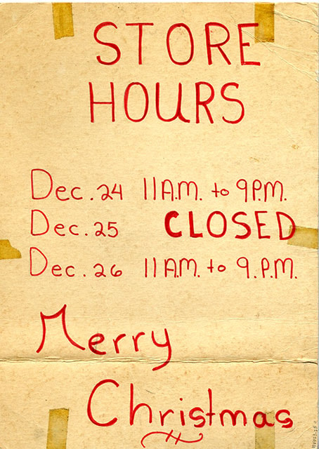
Christmas hours sign for Canada Way Food Market
https://search.heritageburnaby.ca/link/museumdescription20342
- Repository
- Burnaby Village Museum
- Date
- [197-]
- Collection/Fonds
- Harry Toy fonds
- Description Level
- Item
- Physical Description
- 1 sign : red ink on cardboard
- Scope and Content
- Item consists of a double sided handwritten sign in red ink listing Christmas store hours for the Canada Way Food Market. Sign reads: "STORE HOURS / Dec. 24 11 A.M. to 9 P.M. / Dec. 25 Closed / Dec. 26 11 A.M. to 9 P.M. / Merry / Christmas". The Canada Way Food Market was located at 4694 Canada Wa…
- Repository
- Burnaby Village Museum
- Collection/Fonds
- Harry Toy fonds
- Description Level
- Item
- Physical Description
- 1 sign : red ink on cardboard
- Scope and Content
- Item consists of a double sided handwritten sign in red ink listing Christmas store hours for the Canada Way Food Market. Sign reads: "STORE HOURS / Dec. 24 11 A.M. to 9 P.M. / Dec. 25 Closed / Dec. 26 11 A.M. to 9 P.M. / Merry / Christmas". The Canada Way Food Market was located at 4694 Canada Way, Burnaby.
- Subjects
- Holidays - Christmas
- Names
- Canada Way Food Market
- Accession Code
- BV023.25.4
- Access Restriction
- No restrictions
- Reproduction Restriction
- No known restrictions
- Date
- [197-]
- Media Type
- Textual Record
- Related Material
- See also BV023.16.19 - Interview with Harry Toy, Beverley Babey and Christina Toy
- For associated artifacts from Canada Way Food Market see Accession BV023.17
- Scan Resolution
- 600
- Scan Date
- 2023-11-30
- Notes
- Title based on contents of item
Images
![Christmas hours sign for Canada Way Food Market, [197-] thumbnail](/media/hpo/_Data/_BVM_Textual_Records/2023/2023_0025_0004_001.jpg)
![Harry's new prices sign for Canada Way Food Market, [197-] thumbnail](/media/hpo/_Data/_BVM_Textual_Records/2023/2023_0025_0008_001.jpg?width=280)
Harry's new prices sign for Canada Way Food Market
https://search.heritageburnaby.ca/link/museumdescription20344
- Repository
- Burnaby Village Museum
- Date
- [197-]
- Collection/Fonds
- Harry Toy fonds
- Description Level
- Item
- Physical Description
- 1 sign : plastic dry erase sheet
- Scope and Content
- Item consists of a handwritten sign in black marker on verso of a Dairyland Products list. The handwritten sign is titled "HARRY - NEW PRICES" listing prices for various food products sold at the Canada Way Food Market located at 4694 Canada Way, Burnaby. Other side of sign is titled "Dairyland SUP…
- Repository
- Burnaby Village Museum
- Collection/Fonds
- Harry Toy fonds
- Description Level
- Item
- Physical Description
- 1 sign : plastic dry erase sheet
- Material Details
- dry erase sheet; printed in col. one side; verso of sign with handwritten notes in black ink
- Scope and Content
- Item consists of a handwritten sign in black marker on verso of a Dairyland Products list. The handwritten sign is titled "HARRY - NEW PRICES" listing prices for various food products sold at the Canada Way Food Market located at 4694 Canada Way, Burnaby. Other side of sign is titled "Dairyland SUPER COOL TASTE" and includes various Dairyland products with refillable white oval shape next to name of each product.
- Names
- Canada Way Food Market
- Accession Code
- BV023.25.8
- Access Restriction
- No restrictions
- Reproduction Restriction
- No known restrictions
- Date
- [197-]
- Media Type
- Textual Record
- Related Material
- See also BV023.16.19 - Interview with Harry Toy, Beverley Babey and Christina Toy
- For associated artifacts from Canada Way Food Market see Accession BV023.17
- Scan Resolution
- 600
- Scan Date
- 2023-11-30
- Notes
- Title based on contents of item
Images
![Harry's new prices sign for Canada Way Food Market, [197-] thumbnail](/media/hpo/_Data/_BVM_Textual_Records/2023/2023_0025_0008_001.jpg)

![New Year's Day sign for Canada Way Food Market, [197-] thumbnail](/media/hpo/_Data/_BVM_Textual_Records/2023/2023_0025_0005_001.jpg?width=280)
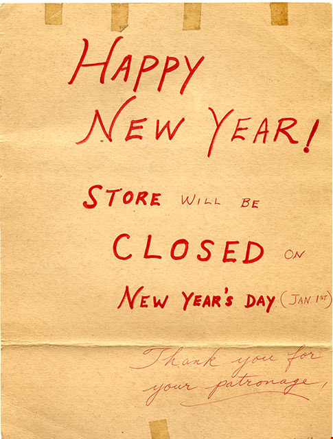
New Year's Day sign for Canada Way Food Market
https://search.heritageburnaby.ca/link/museumdescription20343
- Repository
- Burnaby Village Museum
- Date
- [197-]
- Collection/Fonds
- Harry Toy fonds
- Description Level
- Item
- Physical Description
- 1 sign : red ink on cardboard
- Scope and Content
- Item consists of a double sided handwritten sign in red ink announcing the closure of the Canada Way Food Market on New Year's Day. One side of sign reads: "HAPPY / NEW YEAR! / STORE WILL BE CLOSED ON / NEW YEAR'S DAY (JAN. 1ST) / Thank you for your patronage!" and the other side of sign reads: "H…
- Repository
- Burnaby Village Museum
- Collection/Fonds
- Harry Toy fonds
- Description Level
- Item
- Physical Description
- 1 sign : red ink on cardboard
- Scope and Content
- Item consists of a double sided handwritten sign in red ink announcing the closure of the Canada Way Food Market on New Year's Day. One side of sign reads: "HAPPY / NEW YEAR! / STORE WILL BE CLOSED ON / NEW YEAR'S DAY (JAN. 1ST) / Thank you for your patronage!" and the other side of sign reads: "Happy / NEW / YEAR! / STORE WILL BE / CLOSED ON / NEW YEAR'S DAY (JAN. 1ST.) / Thank You". The Canada Way Food Market was located at 4694 Canada Way, Burnaby.
- Subjects
- Holidays
- Names
- Canada Way Food Market
- Accession Code
- BV023.25.5
- Access Restriction
- No restrictions
- Reproduction Restriction
- No known restrictions
- Date
- [197-]
- Media Type
- Textual Record
- Related Material
- See also BV023.16.19 - Interview with Harry Toy, Beverley Babey and Christina Toy
- For associated artifacts from Canada Way Food Market see Accession BV023.17
- Scan Resolution
- 600
- Scan Date
- 2023-11-30
- Notes
- Title based on contents of item
Images
![New Year's Day sign for Canada Way Food Market, [197-] thumbnail](/media/hpo/_Data/_BVM_Textual_Records/2023/2023_0025_0005_001.jpg)

Certificate of Canadian Citizenship issued to Quon Lip Lee
https://search.heritageburnaby.ca/link/museumdescription16718
- Repository
- Burnaby Village Museum
- Date
- 6 Oct. 1966
- Collection/Fonds
- Quon Lip Lee fonds
- Description Level
- Item
- Physical Description
- 1 photograph (tiff)
- Scope and Content
- Item consists of a Certificate of Canadian Citizenship issued to Quon Lip Lee on October 6, 1966. The back of the certificate includes vitial information including date of birth, marital status and date of issue.
- Repository
- Burnaby Village Museum
- Collection/Fonds
- Quon Lip Lee fonds
- Description Level
- Item
- Physical Description
- 1 photograph (tiff)
- Scope and Content
- Item consists of a Certificate of Canadian Citizenship issued to Quon Lip Lee on October 6, 1966. The back of the certificate includes vitial information including date of birth, marital status and date of issue.
- Creator
- Government of Canada
- Names
- Lee, Quon Lip
- Accession Code
- BV021.18.2
- Access Restriction
- No restrictions
- Reproduction Restriction
- May be restricted by third party rights
- Date
- 6 Oct. 1966
- Media Type
- Textual Record
- Photograph
- Scan Resolution
- 600
- Scan Date
- April 8, 2021
- Scale
- 100
- Notes
- Title based on contents of item
Images


Head tax certificate issued to Dung Way How
https://search.heritageburnaby.ca/link/museumdescription15546
- Repository
- Burnaby Village Museum
- Date
- 1922-1934 (date of original), copied 2021
- Collection/Fonds
- Burnaby Village Museum Document collection
- Description Level
- Item
- Physical Description
- 1 certificate (tiff) : col. ; 600 dpi
- Scope and Content
- Item consists of a head tax certificate issued by the Dominion of Canada - Immigration Branch - Department of the Interior to Dung Way How (Dong Howe). The certificate was first issued on March 18, 1922 and includes certification stamps on the front along with a photograph of Dung Way How. Certifi…
- Repository
- Burnaby Village Museum
- Collection/Fonds
- Burnaby Village Museum Document collection
- Description Level
- Item
- Physical Description
- 1 certificate (tiff) : col. ; 600 dpi
- Scope and Content
- Item consists of a head tax certificate issued by the Dominion of Canada - Immigration Branch - Department of the Interior to Dung Way How (Dong Howe). The certificate was first issued on March 18, 1922 and includes certification stamps on the front along with a photograph of Dung Way How. Certification stamps on the verso of the certificate were issued by Chinese Immigration authorities between 1922 and 1934. Information on the front of the certificate reads "...This Certifies That / Dung Way How whose photograph is attached / hereto arrived or landed at Vancouver B.C. / on the 23rd day of January 1922 / ex "Empress of Asia" / and upon representations made has been / admitted as exempt from head tax under the / provisions of the Chinese Immigration Act. / The above mentioned party claims / to be a native of Bark Choon Jong in the District of Pon Yue of the age of 20 years. The declaration in this case is C.I.4. No. 3715 Date at Vancouver on March 18, 1922" signed by "Controller of Chinese Immigration". Printed text on verso of certificate reads "IMPORTANT / IT IS NECESSARY THAT THIS / CERTIFICATE BE CAREFULLY / PRESERVED AS IT IS OF VALUE / AS A MEANS OF IDENTIFICATION".
- History
- Dung Way How (Dong Howe) arrived from Bak Chun (North Village), Guangdong in 1922 as a paper son. He had two sons during his first marriage, but the sons remained in China and one died at a young age. He married his second wife Chow Goon Pang through an arranged marriage. She was married twice previously and had a son from each marriage, but neither of them survived. Chow was from Nam Chun (South Village) and arrived in Canada as a paper daughter around the late 1930s or early 1940s. Both Dong and Chow spoke a Poon Yue dialect. The couple raised one daughter Vivian Dong (Dong Jing Yu) in Canada. The Dong family leased and operated the New Fountain hotel in Vancouver located at Abbott Street and Cordova Street. The family later went on to purchase farmland in Burnaby in 1957. The Dong family moved to Burnaby and operated a three acre market garden located at 6220 14th Avenue until 1972. They grew European staples including celery, radishes, green onions, beets, lettuces, endives, as well as Chinese vegetables such as gai lan (Chinese broccoli). There were two Chinese families in the area, including the Wong family who operated the Wong Chew market gardens 6325 14th Avenue. Dong Howe passed away in 1978. Chow Goon Pang passed away in 2000. Their daughter Vivian grew up in Burnaby and attended Riverside Elementary, McPherson Junior High School and Burnaby South Secondary School.
- Creator
- Government of Canada
- Names
- Howe, Dong
- Accession Code
- BV021.13.1
- Access Restriction
- No restrictions
- Reproduction Restriction
- No known restrictions
- Date
- 1922-1934 (date of original), copied 2021
- Media Type
- Textual Record
- Photograph
- Scan Resolution
- 600
- Scan Date
- March 25, 2021
- Scale
- 100
- Notes
- Title based on contents of photograph
Images


![Head tax certificate issued to Lee Quon Lep [Quan Lip Lee], 1921-1949 (date of original), copied 2021 thumbnail](/media/hpo/_Data/_BVM_Textual_Records/2021/2021_0018_0001_001.jpg?width=280)
Head tax certificate issued to Lee Quon Lep [Quan Lip Lee]
https://search.heritageburnaby.ca/link/museumdescription16717
- Repository
- Burnaby Village Museum
- Date
- 1921-1949 (date of original), copied 2021
- Collection/Fonds
- Quon Lip Lee fonds
- Description Level
- Item
- Physical Description
- 1 photograph (tiff)
- Scope and Content
- Item consists of a head tax certificate issued by the Dominion of Canada - Immigration Branch - Department of the (Interior) issued to Lee Quon Lep [sic] [Quon Lip Lee]. The certificate was first issued on December 12, 1921 and includes certification stamps on the front along with a photograph of Q…
- Repository
- Burnaby Village Museum
- Collection/Fonds
- Quon Lip Lee fonds
- Description Level
- Item
- Physical Description
- 1 photograph (tiff)
- Scope and Content
- Item consists of a head tax certificate issued by the Dominion of Canada - Immigration Branch - Department of the (Interior) issued to Lee Quon Lep [sic] [Quon Lip Lee]. The certificate was first issued on December 12, 1921 and includes certification stamps on the front along with a photograph of Quan Lip Lee. Certification stamps on the verso of the certificate were issued by Canadian and Chinese Immigration authorities between 1924 and 1949. Information on the front of the certificate reads "DOMINION OF CANADA / IMMIGRATION BRANCH - DEPARTMENT.../ RECEIVED FRO.../ Lee Quon Lep whose photograph is attached / hereto on the date and at the place hereunder mentioned the sum / of five Hundred Dollars being the head tax due under the / provisions of the Chinese Immigration Act. / The above mentioned party claims / to be a native of Gong Doey Lee / in the district of Sun Way / of the age of 12 years arrived or landed / at Vancouver on the 28th day of / November 1921 ex Empress [sic] of Asia / The declaration in this case is C.I.4 No. 3716 / Dated at Vancouver on Dec 12, 1921_19_/ (signature) / CONTROLLER OF CHINESE IMMIGRATION". Printed text on verso of certificate reads "IMPORTANT / IT IS NECESSARY THAT THIS / CERTIFICATE BE CAREFULLY / PRESERVED AS IT IS OF VALUE / AS A MEANS OF IDENTIFICATION" along with Chinese language characters printed vertically below.
- Creator
- Government of Canada
- Names
- Lee, Quon Lip
- Accession Code
- BV021.18.1
- Access Restriction
- No restrictions
- Reproduction Restriction
- No known restrictions
- Date
- 1921-1949 (date of original), copied 2021
- Media Type
- Textual Record
- Photograph
- Scan Resolution
- 600
- Scan Date
- April 8, 2021
- Scale
- 100
- Notes
- Title based on contents of item
Images
![Head tax certificate issued to Lee Quon Lep [Quan Lip Lee], 1921-1949 (date of original), copied 2021 thumbnail](/media/hpo/_Data/_BVM_Textual_Records/2021/2021_0018_0001_001.jpg)


Douglas Road School site
https://search.heritageburnaby.ca/link/museumdescription11136
- Repository
- Burnaby Village Museum
- Date
- April 19, 1915
- Collection/Fonds
- Ronald G. Scobbie collection
- Description Level
- Item
- Physical Description
- 1 survey plan : blueprint on paper ; 56 x 54 cm
- Scope and Content
- Survey plan of "Douglas Road School Site / Burnaby Municipality" "Being Lot 21, of Blocks 1-5 inc. 11 & 12 of the subd. of north half of Lot 80, Group 1, New Westminster District".
- Repository
- Burnaby Village Museum
- Collection/Fonds
- Ronald G. Scobbie collection
- Description Level
- Item
- Physical Description
- 1 survey plan : blueprint on paper ; 56 x 54 cm
- Material Details
- Scale 40 feet = 1 inch
- Scope and Content
- Survey plan of "Douglas Road School Site / Burnaby Municipality" "Being Lot 21, of Blocks 1-5 inc. 11 & 12 of the subd. of north half of Lot 80, Group 1, New Westminster District".
- Creator
- McGugan, Donald Johnston
- Subjects
- Buildings - Schools
- Names
- Douglas Road School
- Responsibility
- Burnett & McGugan, Engineers and Surveyors
- Geographic Access
- Canada Way
- Street Address
- 4861 Canada Way
- Accession Code
- BV003.83.15
- Access Restriction
- No restrictions
- Reproduction Restriction
- No known restrictions
- Date
- April 19, 1915
- Media Type
- Cartographic Material
- Historic Neighbourhood
- Burnaby Lake (Historic Neighbourhood)
- Planning Study Area
- Douglas-Gilpin Area
- Scan Resolution
- 440
- Scan Date
- 22-Dec-2020
- Scale
- 100
- Notes
- Title based on contents of plan
- Note in black ink on verso of plan reads: "1747"
- Oath on plan reads: "I, D.G. McGugan..." "...and did person- ally superintend the survey..." "...completed on the 3rd day of April 1915"; signed by D.J. McGugan, notarized by "H.A. Eastman", sworn "...19th day of April 1915" "Burnett and McGugan" "B.C. Land Surveyors Etc. New Westminster, B.C.."
Images

![Claude Hill, the son of Bernard and Marian Hill, [1888]. Item no. 477-933 thumbnail](/media/hpo/_Data/_Archives_Images/_Unrestricted/477/477-933.jpg?width=280)
Interview with Claude Hill and Marion Hill November 7, 1977 - Track 1
https://search.heritageburnaby.ca/link/oralhistory204
- Repository
- City of Burnaby Archives
- Date Range
- 1892-1905
- Length
- 0:09:33
- Summary
- This portion of the interview pertains to A. Claude Hill's memories of Christmas as a young boy, living in the Deer Lake area. He tells stories of the antics he got into with his brothers. Claude's wife, Marion Hill speaks encouraging words.
- Repository
- City of Burnaby Archives
- Summary
- This portion of the interview pertains to A. Claude Hill's memories of Christmas as a young boy, living in the Deer Lake area. He tells stories of the antics he got into with his brothers. Claude's wife, Marion Hill speaks encouraging words.
- Date Range
- 1892-1905
- Photo Info
- Claude Hill, the son of Bernard and Marian Hill, [1888]. Item no. 477-933
- Length
- 0:09:33
- Subjects
- Holidays - Christmas
- Geographic Access
- Douglas Road
- Canada Way
- Historic Neighbourhood
- Burnaby Lake (Historic Neighbourhood)
- Planning Study Area
- Douglas-Gilpin Area
- Interviewer
- Stevens, Colin
- Interview Date
- November 7, 1977
- Scope and Content
- Recording is of an interview with A. Claude Hill and his wife Marion Hill, conducted by Colin Stevens, November 7, 1977. Major themes discussed are: Christmas traditions and his Deer Lake neighbourhood.
- Biographical Notes
- Claude Hill was born in England about 1885, the eldest son of Marian (Berkeley) and Bernard R. Hill. His younger sibling were Frank, Winnie and Minard Gerald “Gerry.” Claude Hill was named after Bernard’s older brother, Louis Claude Hill. Claude's father, Bernard R. Hill was born in Bengal, India while his father worked for the East Indian Railway. He and his older brother Uncle Claude became strawberry farmers in Burnaby despite their years of training as engineers. Between them, the Hill brothers owned all the land between Burnaby Lake and Deer Lake where Deer Creek runs, and half way around Deer Lake. After the decline in the strawberry industry, Bernard worked as a surveyor for the municipality. He also served as Burnaby Councillor and School Trustee. Bernard built his family home at Douglas Road near Deer Lake in 1892. His oldest child, Claude was seven years old at the time and his first years of school in Burnaby were at Douglas Road. Later, Claude rode a horse and buggy with his younger brother to travel to school in New Westminster. A.Claude Hill married Marion "Mamie" in his early twenties.
- Total Tracks
- 4
- Total Length
- 0:30:00
- Interviewee Name
- Hill, Claude
- Hill, Marion
- Collection/Fonds
- Burnaby Historical Society fonds
- Subseries
- Oral history subseries
- Media Type
- Sound Recording
- Web Notes
- Interview was digitized in 2010 allowing it to be accessible on Heritage Burnaby. The digitization project was initiated by the Community Heritage Commission with support from City of Burnaby Council and the BC History Digitization Program of the Irving K. Barber Learning Centre, University of British Columbia. It was recognized by the Heritage Society of BC with an award in 2012.
Images
![Claude Hill, the son of Bernard and Marian Hill, [1888]. Item no. 477-933 thumbnail](/media/hpo/_Data/_Archives_Images/_Unrestricted/477/477-933.jpg)
Audio Tracks
Track one of interview with Claude Hill and Marion Hill
Track one of interview with Claude Hill and Marion Hill
https://search.heritageburnaby.ca/media/hpo/_Data/_Archives_Oral_Histories/_Unrestricted/MSS137-019-1/MSS137-019-1_Track_1.mp3
Interview with Claude Hill and Marion Hill November 7, 1977 - Track 4
https://search.heritageburnaby.ca/link/oralhistory250
- Repository
- City of Burnaby Archives
- Date Range
- 1892-1905
- Length
- 0:04:58
- Summary
- This portion of the interview pertains to A. Claude Hill's memories of how his father cleared land to build a house, including the equipment that was used.
- Repository
- City of Burnaby Archives
- Summary
- This portion of the interview pertains to A. Claude Hill's memories of how his father cleared land to build a house, including the equipment that was used.
- Date Range
- 1892-1905
- Photo Info
- Claude Hill, the son of Bernard and Marian Hill, [1888]. Item no. 477-933
- Length
- 0:04:58
- Names
- Hill, Bernard R
- Subjects
- Land Clearing
- Geographic Access
- Douglas Road
- Canada Way
- Historic Neighbourhood
- Burnaby Lake (Historic Neighbourhood)
- Planning Study Area
- Douglas-Gilpin Area
- Interviewer
- Stevens, Colin
- Interview Date
- November 7, 1977
- Scope and Content
- Recording is of an interview with A. Claude Hill and his wife Marion Hill, conducted by Colin Stevens, November 7, 1977. Major themes discussed are: Christmas traditions and his Deer Lake neighbourhood.
- Biographical Notes
- Claude Hill was born in England about 1885, the eldest son of Marian (Berkeley) and Bernard R. Hill. His younger sibling were Frank, Winnie and Minard Gerald “Gerry.” Claude Hill was named after Bernard’s older brother, Louis Claude Hill. Claude's father, Bernard R. Hill was born in Bengal, India while his father worked for the East Indian Railway. He and his older brother Uncle Claude became strawberry farmers in Burnaby despite their years of training as engineers. Between them, the Hill brothers owned all the land between Burnaby Lake and Deer Lake where Deer Creek runs, and half way around Deer Lake. After the decline in the strawberry industry, Bernard worked as a surveyor for the municipality. He also served as Burnaby Councillor and School Trustee. Bernard built his family home at Douglas Road near Deer Lake in 1892. His oldest child, Claude was seven years old at the time and his first years of school in Burnaby were at Douglas Road. Later, Claude rode a horse and buggy with his younger brother to travel to school in New Westminster. A.Claude Hill married Marion "Mamie" in his early twenties.
- Total Tracks
- 4
- Total Length
- 0:30:00
- Interviewee Name
- Hill, Claude
- Hill, Marion
- Collection/Fonds
- Burnaby Historical Society fonds
- Subseries
- Oral history subseries
- Media Type
- Sound Recording
- Web Notes
- Interview was digitized in 2010 allowing it to be accessible on Heritage Burnaby. The digitization project was initiated by the Community Heritage Commission with support from City of Burnaby Council and the BC History Digitization Program of the Irving K. Barber Learning Centre, University of British Columbia. It was recognized by the Heritage Society of BC with an award in 2012.
Images
Audio Tracks
Track four of interview with Claude Hill and Marion Hill
Track four of interview with Claude Hill and Marion Hill
https://search.heritageburnaby.ca/media/hpo/_Data/_Archives_Oral_Histories/_Unrestricted/MSS137-019-1/MSS137-019-1_Track_4.mp3![Sprott sisters sitting together on a long tressle. Helen Sprott is seated on the right, wearing glasses [1906]. Item no. HV978.1.10 thumbnail](/media/hpo/_Data/_Archives_Images/_Unrestricted/1977/197800010010.jpg?width=280)
Interview with Helen Sprott August 10, 1977 - Track 1
https://search.heritageburnaby.ca/link/oralhistory207
- Repository
- City of Burnaby Archives
- Date Range
- 1900-1908
- Length
- 0:05:47
- Summary
- This portion of the interview pertains to Helen Fanny Sprott's memories of her family's first years of living in Burnaby. She mentions the Hazard House and Mayfield Farms.
- Repository
- City of Burnaby Archives
- Summary
- This portion of the interview pertains to Helen Fanny Sprott's memories of her family's first years of living in Burnaby. She mentions the Hazard House and Mayfield Farms.
- Date Range
- 1900-1908
- Photo Info
- Sprott sisters sitting together on a long tressle. Helen Sprott is seated on the right, wearing glasses [1906]. Item no. HV978.1.10
- Length
- 0:05:47
- Subjects
- Buildings - Residences - Houses
- Geographic Access
- Canada Way
- Burnaby Lake
- Historic Neighbourhood
- Burnaby Lake (Historic Neighbourhood)
- Planning Study Area
- Morley-Buckingham Area
- Interview Date
- August 10, 1977
- Scope and Content
- Recording is of an interview with Helen Sprott, August 10, 1977. Major themes discussed are: the Sprott home.
- Biographical Notes
- Helen Sprott was born in Burnaby on June 22, 1902. Her father, Louis Edgar Sprott and younger brother came out to Burnaby from England, following their older brother Charles F. Sprott. The two younger brothers were in the Merchant Marines together prior to arriving in to Burnaby and learning to farm. Louis Edgar Sprott and Helen Louise F. Nicholls were married June 30, 1900 and stayed at the Haszard House while their own house was being built. By 1902, "the Dovecote" was built and Helen was born. The house was added on to and later renamed "Mayfield Farms." Helen's grandmother and aunt on her mother's side came to live at Mayfield Farms in 1907 or 1908. Helen Sprott was living in Penticton at the time of her death, April 8, 1978 at the age of seventy-five.
- Total Tracks
- 2
- Total Length
- 0:08:57
- Interviewee Name
- Sprott, Helen
- Collection/Fonds
- Burnaby Historical Society fonds
- Subseries
- Oral history subseries
- Media Type
- Sound Recording
Images
![Sprott sisters sitting together on a long tressle. Helen Sprott is seated on the right, wearing glasses [1906]. Item no. HV978.1.10 thumbnail](/media/hpo/_Data/_Archives_Images/_Unrestricted/1977/197800010010.jpg)
Audio Tracks
Track one of interview with Helen Sprott
Track one of interview with Helen Sprott
https://search.heritageburnaby.ca/media/hpo/_Data/_Archives_Oral_Histories/_Unrestricted/MSS137-019-2/MSS137-019-2_Track_1.mp3
Interview with Minard Hill February 9, 1978 - Track 3
https://search.heritageburnaby.ca/link/oralhistory196
- Repository
- City of Burnaby Archives
- Date Range
- 1880-1914
- Length
- 0:10:09
- Summary
- This portion of the interview pertains to Minard Gerald "Gerry" Hill's relatives in England, his father's early life as well as life on the strawberry farm in Burnaby.
- Repository
- City of Burnaby Archives
- Summary
- This portion of the interview pertains to Minard Gerald "Gerry" Hill's relatives in England, his father's early life as well as life on the strawberry farm in Burnaby.
- Date Range
- 1880-1914
- Photo Info
- Minard Gerald Hill in uniform, 1914. Item no. 477-926
- Length
- 0:10:09
- Names
- Hill, Bernard R
- Geographic Access
- Douglas Road
- Canada Way
- Historic Neighbourhood
- Burnaby Lake (Historic Neighbourhood)
- Planning Study Area
- Douglas-Gilpin Area
- Interviewer
- Stevens, Colin
- Interview Date
- February 9, 1978
- Scope and Content
- Recording is of an interview with Minard Gerald "Gerry" Hill conducted by Colin Stevens, February 9, 1978. Major themes discussed are: the Burnaby Lake Neighbourhood, Gilley Brothers Logging Company and his father, Bernard Hill.
- Biographical Notes
- Minard Gerald “Gerry” Hill was born in Burnaby on July 31, 1893 to Marian (Berkeley) and Bernard Richard Hill. He was the youngest child in the family with older siblings Frank, Claude and Winnie. Bernard R. Hill was born in Bengal, India while his father worked for the East Indian Railway. He and his older brother Claude became strawberry farmers in Burnaby despite their years of training as engineers. Between them, the Hill brothers owned all the land between Burnaby Lake and Deer Lake where Deer Creek runs, and half way around Deer Lake. Bernard built his family home at Douglas Road near Deer Lake in 1892. After the decline in the strawberry industry, Bernard worked as a surveyor for the municipality. He also served as Burnaby Councillor and School Trustee. Gerry attended Miss Harriet Woodward’s kindergarten class, and went on to Edmonds School with Miss Ellen Lister as his teacher. He later went to Central high school in New Westminster, often on horseback. Gerry served in World War I, signing his recruitment papers November 9, 1914. When he returned home, he worked felling trees, then as an apprentice surveyor and finally as a carpenter. Minard Gerald “Gerry” Hill married Charlotte Elizabeth “Elizabeth” Vidal on September 28, 1920 and single-handedly built a house for him and his wife about a thousand feet from his parents’ home. He also bought property at Yellow Point, Vancouver Island around this time. By the early 1930s Gerry had moved to Yellow Point permanently and begun work building the lodge. Elizabeth and Gerry’s child, Richard Grant McEwan Hill was born at Ladysmith hospital. Charlotte Elizabeth “Elizabeth” (Vidal) Hill died February 11, 1984 at the age of eighty-seven. Minard Gerald “Gerry” Hill died January 30, 1988 at the age of ninety-three.
- Total Tracks
- 8
- Total Length
- 1:13:56
- Interviewee Name
- Hill, Minard Gerald "Gerry"
- Interview Location
- Yellow Point, Vancouver Island
- Collection/Fonds
- Burnaby Historical Society fonds
- Subseries
- Oral history subseries
- Media Type
- Sound Recording
- Web Notes
- Interview was digitized in 2010 allowing it to be accessible on Heritage Burnaby. The digitization project was initiated by the Community Heritage Commission with support from City of Burnaby Council and the BC History Digitization Program of the Irving K. Barber Learning Centre, University of British Columbia. It was recognized by the Heritage Society of BC with an award in 2012.
Images

Audio Tracks
Track three of interview with Minard Hill
Track three of interview with Minard Hill
https://search.heritageburnaby.ca/media/hpo/_Data/_Archives_Oral_Histories/_Unrestricted/MSS137-018-1/MSS137-018-1_Track_3.mp3
Schou Street School site
https://search.heritageburnaby.ca/link/museumdescription11138
- Repository
- Burnaby Village Museum
- Date
- April 12, 1915
- Collection/Fonds
- Ronald G. Scobbie collection
- Description Level
- Item
- Physical Description
- 1 survey plan : blueprint on paper ; 56 x 54 cm
- Scope and Content
- Survey plan of "Schou Street School Site / Burnaby Municipality" "Being Lot 1-12 inc. of Block 47, of subd. of Blocks 8-12 and 15-49 inclusive, Lot 69, Group 1" "New Westminster District";
- Repository
- Burnaby Village Museum
- Collection/Fonds
- Ronald G. Scobbie collection
- Description Level
- Item
- Physical Description
- 1 survey plan : blueprint on paper ; 56 x 54 cm
- Material Details
- Scale 40 feet = 1 inch
- Scope and Content
- Survey plan of "Schou Street School Site / Burnaby Municipality" "Being Lot 1-12 inc. of Block 47, of subd. of Blocks 8-12 and 15-49 inclusive, Lot 69, Group 1" "New Westminster District";
- Creator
- Burnett, Geoffrey K.
- Subjects
- Buildings - Schools
- Names
- Schou Street School
- Responsibility
- Burnett & McGugan, Engineers and Surveyors
- Geographic Access
- Canada Way
- Grandview Highway
- Gilmore Avenue
- Street Address
- 4054 Norfolk Street
- Accession Code
- BV003.83.17
- Access Restriction
- No restrictions
- Reproduction Restriction
- No known restrictions
- Date
- April 12, 1915
- Media Type
- Cartographic Material
- Historic Neighbourhood
- Broadview (Historic Neighbourhood)
- Planning Study Area
- Cascade-Schou Area
- Scan Resolution
- 440
- Scan Date
- 22-Dec-2020
- Scale
- 100
- Notes
- Title based on contents of plan
- Oath on plan reads: "I, Geoffrey K. Burnett...did person- ally superintend the survey..." "...completed on the 12th day of April 1915"; signed by Geoffrey K. Burnett, notarized by "S.F. Mark", sworn "..12th day.. April 1915" "Burnett and McGugan" "B.C. Land Surveyors Etc. New Westminster, B.C.
- ."handwritten on back, "1751"
- two school buildings are shown on this blueprint, "Old School Building", "New School Building"
Images

![Burna-bee Royal Chalet, [between 1973 and 1975] thumbnail](/media/hpo/_Data/_BVM_Images/2015/2015_0035_0211_001.jpg?width=280)
Burna-bee Royal Chalet
https://search.heritageburnaby.ca/link/museumdescription4942
- Repository
- Burnaby Village Museum
- Date
- [between 1973 and 1975]
- Collection/Fonds
- Burnaby Girl Guides fonds
- Description Level
- Item
- Physical Description
- 1 poster : 5 photographs : col. + textual record mounted on board 44.5 x 33 cm
- Scope and Content
- Item consists of a large poster titled "Burna-bee Royal Chalet / our cabin on Hollyburn Mt." The poster includes a history about the Burnaby Royal Girl Guide Chalet on Hollyburn Mountain in West Vancouver as well as colour photographs of the cabin in the winter and summertime.The cabin was original…
- Repository
- Burnaby Village Museum
- Collection/Fonds
- Burnaby Girl Guides fonds
- Description Level
- Item
- Physical Description
- 1 poster : 5 photographs : col. + textual record mounted on board 44.5 x 33 cm
- Scope and Content
- Item consists of a large poster titled "Burna-bee Royal Chalet / our cabin on Hollyburn Mt." The poster includes a history about the Burnaby Royal Girl Guide Chalet on Hollyburn Mountain in West Vancouver as well as colour photographs of the cabin in the winter and summertime.The cabin was originally built in 1934 by Gus Johnson with the assistance of Tom Gibson and was then known as the Hollyburn Pacific Pacific Ski Club. It was originally constructed on the highest point of land halfway between Hollyburn Lodge and West Lake and was often used as a ski jump in the winter. The cabin was moved in 1940 to make way for the water supply from West Lake and taken apart and reerected at it's present site on Cypress Mountain. It took nine days diassemble and move the cabin log by log. It continued to be used as the Cypress Ski Club and a few years later, it was renamed the Vancouver Ski Club. It continued to be used as a ski club until 1963 when the Burnaby Girl Guides leased the building with an option to purchase which they excercised in 1965. Many guiders rode the chairlift to access the cabin for winter camping and skiing until the chairlift burned in June 1965. After the fire, access to the cabin was restricted since it took over two and a half hours to hike in depending on weather conditions.
- Subjects
- Organizations - Girls' Societies and Clubs
- Recreational Activities - Camping
- Natural Phenomena - Snow
- Names
- Girl Guides of Canada
- Accession Code
- BV015.35.211
- Access Restriction
- No restrictions
- Reproduction Restriction
- May be restricted by third party rights
- Date
- [between 1973 and 1975]
- Media Type
- Photograph
- Textual Record
- Scan Resolution
- 600
- Scan Date
- 06/11/2018
- Notes
- Transcribed title
Images
![Burna-bee Royal Chalet, [between 1973 and 1975] thumbnail](/media/hpo/_Data/_BVM_Images/2015/2015_0035_0211_001.jpg)
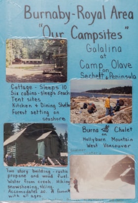
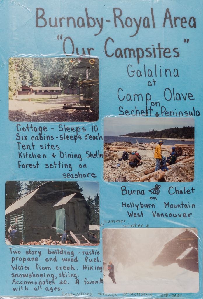
Burnaby - Royal Area "Our Campsites"
https://search.heritageburnaby.ca/link/museumdescription4944
- Repository
- Burnaby Village Museum
- Date
- [ca. 1975]
- Collection/Fonds
- Burnaby Girl Guides fonds
- Description Level
- Item
- Physical Description
- 1 poster : 4 photographs : col. + textual record mounted on board 28 x 40.5 cm and laminated
- Scope and Content
- Item consists of a handwritten poster titled "Burnaby - Royal Area / "Our Campsites"" with four colour photographs of Girl Guide campsites in Sechelt and West Vancouver. Handwritten annotations describe each photograph from the top right to left "Galalina / at / Camp Olave / on / Sechelt Peninsu…
- Repository
- Burnaby Village Museum
- Collection/Fonds
- Burnaby Girl Guides fonds
- Description Level
- Item
- Physical Description
- 1 poster : 4 photographs : col. + textual record mounted on board 28 x 40.5 cm and laminated
- Scope and Content
- Item consists of a handwritten poster titled "Burnaby - Royal Area / "Our Campsites"" with four colour photographs of Girl Guide campsites in Sechelt and West Vancouver. Handwritten annotations describe each photograph from the top right to left "Galalina / at / Camp Olave / on / Sechelt Peninsula" "Cottage - sleeps 10 / Six cabins - sleeps 5each / Tent sites / Kitchen & Dining Shelter / Forest setting on / seashore" "Burna [bee] Chalet / on / Hollyburn Mountain / West Vancouver / Summer / Winter" "Two story building - rustic / propane and wood fuel / Water from creek. Hiking / snowshoeing, skiing. / Accomodates 20. A favourite / with all ages" "Reservations through M. Matthews ___-____"
- Subjects
- Organizations - Girls' Societies and Clubs
- Recreational Activities - Camping
- Natural Phenomena - Snow
- Geographic Features - Beaches
- Names
- Girl Guides of Canada
- Accession Code
- BV015.35.213
- Access Restriction
- No restrictions
- Reproduction Restriction
- May be restricted by third party rights
- Date
- [ca. 1975]
- Media Type
- Photograph
- Textual Record
- Notes
- Transcribed title
Images
![Camp Olave - Galalina, [between 1973 and 1975] thumbnail](/media/hpo/_Data/_BVM_Images/2015/2015_0035_0212_001.jpg?width=280)
Camp Olave - Galalina
https://search.heritageburnaby.ca/link/museumdescription18408
- Repository
- Burnaby Village Museum
- Date
- [between 1973 and 1975]
- Collection/Fonds
- Burnaby Girl Guides fonds
- Description Level
- Item
- Physical Description
- 1 poster : 8 photographs : col. + textual record mounted on board 44.5 x 33 cm
- Scope and Content
- Item consists of a large poster titled "CAMP OLAVE / GALALINA". The poster consists of eight colour photographs mounted on a board documenting time spent by Burnaby Girl Guides at Camp Olave Galalina Girl Guide camp, north of Sechelt on the Sunshine Coast. Photographs are arranged into two columns…
- Repository
- Burnaby Village Museum
- Collection/Fonds
- Burnaby Girl Guides fonds
- Description Level
- Item
- Physical Description
- 1 poster : 8 photographs : col. + textual record mounted on board 44.5 x 33 cm
- Scope and Content
- Item consists of a large poster titled "CAMP OLAVE / GALALINA". The poster consists of eight colour photographs mounted on a board documenting time spent by Burnaby Girl Guides at Camp Olave Galalina Girl Guide camp, north of Sechelt on the Sunshine Coast. Photographs are arranged into two columns and four rows. The poster includes two photographs (top row) identified with text "Beach at Camp Olave"; two photographs (second row) identified with text "Girl Guide Huts on Galalina" and "Guiders Cottage on Galaina"; two photographs (third row) identified with text "Cook Kitchen" and two photographs (bottom row) identified with text "Outdoor Showers on Galalina - Continental Style.
- Names
- Girl Guides of Canada
- Accession Code
- BV015.35.212
- Access Restriction
- No restrictions
- Reproduction Restriction
- May be restricted by third party rights
- Date
- [between 1973 and 1975]
- Media Type
- Photograph
- Textual Record
- Scan Resolution
- 600
- Scan Date
- 06/11/2018
- Notes
- Transcribed title
Images
![Camp Olave - Galalina, [between 1973 and 1975] thumbnail](/media/hpo/_Data/_BVM_Images/2015/2015_0035_0212_001.jpg)
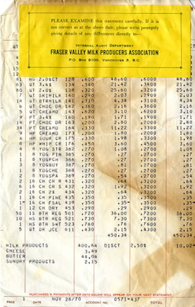
Fraser Valley Milk Producers Association statement
https://search.heritageburnaby.ca/link/museumdescription20345
- Repository
- Burnaby Village Museum
- Date
- 28 Nov. 1970
- Collection/Fonds
- Harry Toy fonds
- Description Level
- Item
- Physical Description
- 2 p.
- Scope and Content
- Item consists of a typewritten statement from the Fraser Valley Milk Producers Association with a summary of purchases for products sold to the Canada Way Food Market.
- Repository
- Burnaby Village Museum
- Collection/Fonds
- Harry Toy fonds
- Description Level
- Item
- Physical Description
- 2 p.
- Material Details
- small yellow page adhered to top of white typewritten page
- Scope and Content
- Item consists of a typewritten statement from the Fraser Valley Milk Producers Association with a summary of purchases for products sold to the Canada Way Food Market.
- Accession Code
- BV023.25.15
- Access Restriction
- No restrictions
- Reproduction Restriction
- No known restrictions
- Date
- 28 Nov. 1970
- Media Type
- Textual Record
- Related Material
- See also BV023.16.19 - Interview with Harry Toy, Beverley Babey and Christina Toy
- For associated artifacts from Canada Way Food Market see Accession BV023.17
- Scan Resolution
- 600
- Scan Date
- 2023-11-30
- Notes
- Title based on contents of item
Images

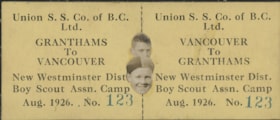
Steamship ticket and Boy Scouts
https://search.heritageburnaby.ca/link/museumdescription20697
- Repository
- Burnaby Village Museum
- Date
- Aug. 1926
- Collection/Fonds
- David Geoffrey Llewellyn collection
- Description Level
- Item
- Physical Description
- 1 ticket : 4 x 10 cm + 1 photograph : b&w ; 2.5 x 1 cm
- Scope and Content
- Item consists of a set of two steamship tickets (conjoined together) for Union S.S. Co. of B.C. Ltd. between Granthams Landing and Vancouver for New Westminster District Boy Scout Association Camp at Granthams Landing in August 1926. A photograph of two Boy Scouts (heads only) is pasted into centre…
- Repository
- Burnaby Village Museum
- Collection/Fonds
- David Geoffrey Llewellyn collection
- Description Level
- Item
- Physical Description
- 1 ticket : 4 x 10 cm + 1 photograph : b&w ; 2.5 x 1 cm
- Scope and Content
- Item consists of a set of two steamship tickets (conjoined together) for Union S.S. Co. of B.C. Ltd. between Granthams Landing and Vancouver for New Westminster District Boy Scout Association Camp at Granthams Landing in August 1926. A photograph of two Boy Scouts (heads only) is pasted into centre of ticket.
- Names
- Boy Scouts of Canada
- Accession Code
- BV995.8.128
- Access Restriction
- No restrictions
- Reproduction Restriction
- No known restrictions
- Date
- Aug. 1926
- Media Type
- Textual Record
- Scan Resolution
- 600
- Notes
- Title based on contents of photograph
- hotograph is part of photograph album BV995.8.1, pasted to page 39
Images

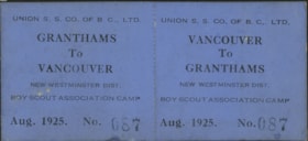
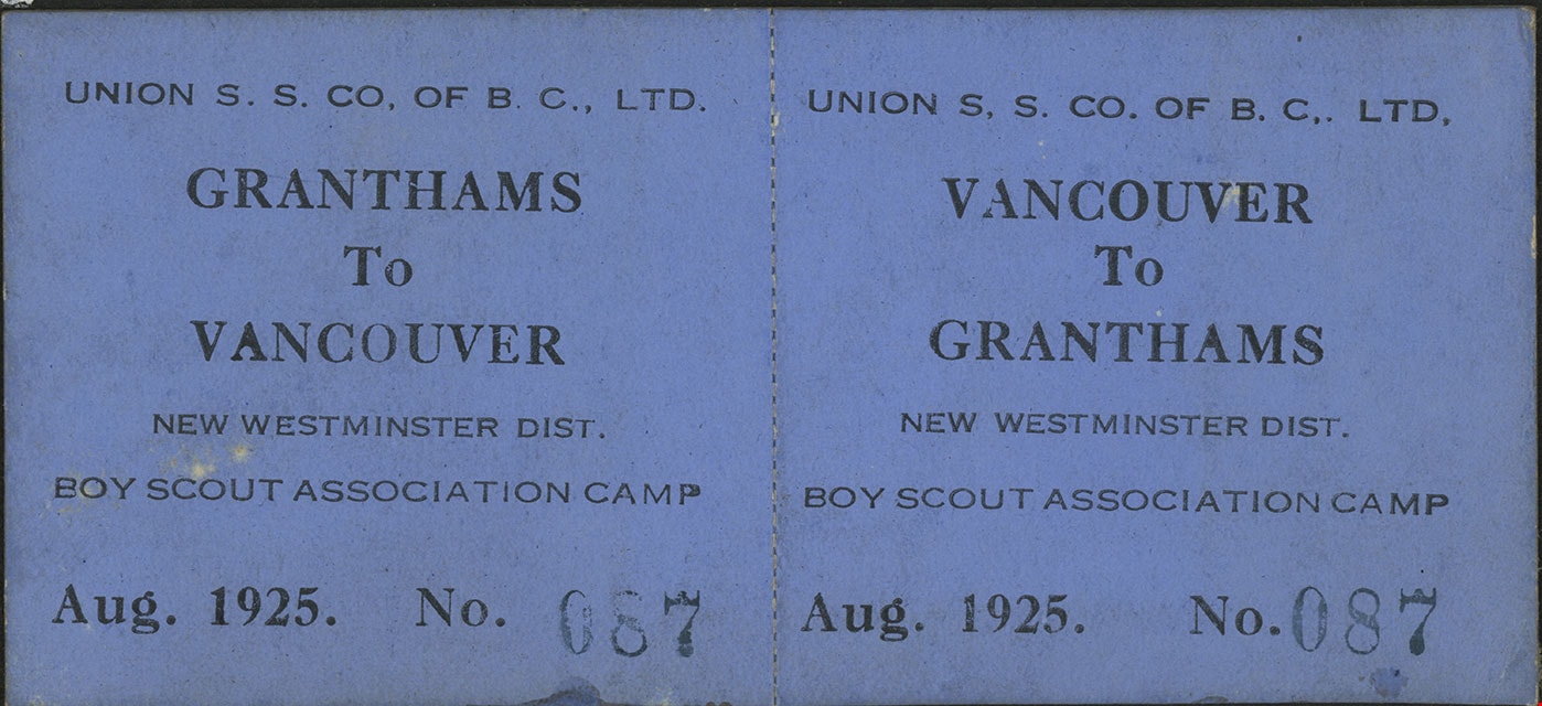
Tickets for New Westminster District Boy Scout camp
https://search.heritageburnaby.ca/link/museumdescription20641
- Repository
- Burnaby Village Museum
- Date
- Aug. 1925
- Collection/Fonds
- David Geoffrey Llewellyn collection
- Description Level
- Item
- Physical Description
- 1 ticket : 4 x 10 cm
- Scope and Content
- Item consists of a set of two steamship tickets (conjoined together) for Union S.S. Co. of B.C. Ltd. between Granthams Landing and Vancouver for New Westminster District Boy Scout Association Camp at Granthams Landing in August 1925.
- Repository
- Burnaby Village Museum
- Collection/Fonds
- David Geoffrey Llewellyn collection
- Description Level
- Item
- Physical Description
- 1 ticket : 4 x 10 cm
- Scope and Content
- Item consists of a set of two steamship tickets (conjoined together) for Union S.S. Co. of B.C. Ltd. between Granthams Landing and Vancouver for New Westminster District Boy Scout Association Camp at Granthams Landing in August 1925.
- Names
- Boy Scouts of Canada
- Accession Code
- BV995.8.72
- Access Restriction
- No restrictions
- Reproduction Restriction
- No known restrictions
- Date
- Aug. 1925
- Media Type
- Textual Record
- Scan Resolution
- 600
- Notes
- Title based on contents of photograph
- Photograph is part of photograph album BV995.8.1, pasted to page 23
Images
![Highways map of British Columbia, Alberta and adjacent states, [1930] thumbnail](/media/hpo/_Data/_BVM_Cartographic_Material/1977/1977_0037_0187_001.jpg?width=280)
Highways map of British Columbia, Alberta and adjacent states
https://search.heritageburnaby.ca/link/museumdescription9668
- Repository
- Burnaby Village Museum
- Date
- [1930]
- Collection/Fonds
- Burnaby Village Museum Map collection
- Description Level
- Item
- Physical Description
- 1 map : col. lithographic print ; both sides ; 89.5 x 58 cm, folded to 11.5 x 20 cm
- Scope and Content
- Double sided road map published by Imperial Oil, Ltd. and featuring the main travelled highway routes of British Columbia, Alberta and the Northwestern-most states of the United States of America. The map is a colour lithograph. The main map is green, with the highways highlighted in red. The litho…
- Repository
- Burnaby Village Museum
- Collection/Fonds
- Burnaby Village Museum Map collection
- Description Level
- Item
- Physical Description
- 1 map : col. lithographic print ; both sides ; 89.5 x 58 cm, folded to 11.5 x 20 cm
- Material Details
- Scale 1 inch = 20 miles
- A.R. THOMSON / CHIEF CARTOGRAPHER
- Scope and Content
- Double sided road map published by Imperial Oil, Ltd. and featuring the main travelled highway routes of British Columbia, Alberta and the Northwestern-most states of the United States of America. The map is a colour lithograph. The main map is green, with the highways highlighted in red. The lithograph was created in Canada by Rolph Clark Stone Ltd in Toronto. The opposite side of the map features inset maps of the following: the Trans-Canada Highway, the highway between Prince Rupert and Prince George, the highway through the Canadian Rockies, and the highway through the Peace River District. Small city plan maps of highways through major cities, as well as advertisements for Imperial Oil products, are also found on the opposite side of the main map. This map is one of four produced by Imperial Oil that covered the most populated areas of Canada from coast to coast and paralleled Imperial Oil's distribution service.
- Creator
- Thomson, A.R.
- Publisher
- Imperial Oil Limited
- Accession Code
- HV977.37.187
- Access Restriction
- No restrictions
- Reproduction Restriction
- No known restrictions
- Date
- [1930]
- Media Type
- Cartographic Material
- Scan Resolution
- 600
- Scan Date
- 2023-11-10
- Notes
- Title based on content of map
Zoomable Images
![Highways map of British Columbia, Alberta and adjacent states, [1930] thumbnail](/media/hpo/_Data/_BVM_Cartographic_Material/1977/1977_0037_0187_003_seadragon/1977_0037_0187_003.jpg?w=280)


Map of South Western Part of British Columbia
https://search.heritageburnaby.ca/link/museumdescription8688
- Repository
- Burnaby Village Museum
- Date
- 1897
- Collection/Fonds
- Burnaby Village Museum Map collection
- Description Level
- Item
- Physical Description
- 1 map : col. ink on paper ; 68 x 88 cm
- Scope and Content
- Item consists of a "MAP OF THE SOUTH-WESTERN PART OF BRITISH COLUMBIA”. Map identifies geographic land districts of New Westminster District; Coast District; Lillooet District; Yale District, Kamloops Division, Yale Division and districts on Vancouver Island. Map also includes the northern portions…
- Repository
- Burnaby Village Museum
- Collection/Fonds
- Burnaby Village Museum Map collection
- Description Level
- Item
- Physical Description
- 1 map : col. ink on paper ; 68 x 88 cm
- Material Details
- Scale [1:633600]
- Scope and Content
- Item consists of a "MAP OF THE SOUTH-WESTERN PART OF BRITISH COLUMBIA”. Map identifies geographic land districts of New Westminster District; Coast District; Lillooet District; Yale District, Kamloops Division, Yale Division and districts on Vancouver Island. Map also includes the northern portions of the State of Washington below the 49th parallel.
- Publisher
- The Colonist Litho Victoria B.C.
- Responsibility
- Martin, George Bohun
- Accession Code
- BV993.12.12
- Access Restriction
- No restrictions
- Reproduction Restriction
- No known restrictions
- Date
- 1897
- Media Type
- Cartographic Material
- Scan Resolution
- 600
- Scan Date
- 2023-08-17
- Notes
- Transcribed title
- Scale equals 1 inch to 10 miles
- "Compiled and drawn by direction of the Honouable G.B. Martin, Chief Commissioner of Lands and Works, Victoria, B.C."
- Signed by Surveyor General "Tom Kains"
