Narrow Results By

Bird's Eye View of the Burnaby Lake Area
https://search.heritageburnaby.ca/link/museumdescription15144
- Repository
- Burnaby Village Museum
- Date
- 1977
- Collection/Fonds
- Century Park Museum Association fonds
- Description Level
- Item
- Physical Description
- 1 map : b&w print on paper ; 43 x 63.5 cm
- Scope and Content
- Item consists of a map titled "Birds Eye View of the Burnaby Lake Area Circa 1910". The overview of the Burnaby Lake area was compiled and drawn at Heritage Village by curator John Adams and artist, Carol Swan. The map identifies the Burnaby Lake inter-urban tram line; roads including: Sperling Ave…
- Repository
- Burnaby Village Museum
- Collection/Fonds
- Century Park Museum Association fonds
- Description Level
- Item
- Physical Description
- 1 map : b&w print on paper ; 43 x 63.5 cm
- Material Details
- Scale indeterminable
- Scope and Content
- Item consists of a map titled "Birds Eye View of the Burnaby Lake Area Circa 1910". The overview of the Burnaby Lake area was compiled and drawn at Heritage Village by curator John Adams and artist, Carol Swan. The map identifies the Burnaby Lake inter-urban tram line; roads including: Sperling Avenue (Pole Line Road); Gilpin Avenue; Douglas Road; trail to Vancouver Westminster Road (Kingsway); Buckingham Avenue; Haszard Street; various farms and residences including: Charles Sprott "Norland"; H.T. Ceperley "Fairacres"; Claude Hill's "Brookfield farm" and "Broadview"; F.J. Hart's "Avalon"; Miss Woodward's former and new home, school and post office; Councillor Edgar's hunting cabin; Edgar Sprott's "Mayfield farm" and "Mayfield Lodge"; F.J. Peers "Greyfriars"; Arthur de Windt Haszard; Bernard Hill's boathouse as well as other landmarks including: Doran's Mill; tram stations; Burnaby Lake Store; logging camps; wood cutter's shacks; ice houses; cranberry bog; Still Creek; Deer Lake; Burnaby Lake; Deer Lake Creek; Provincial Government Reserve Proposed Hospital (later Oakalla Prison).
- Creator
- Adams, John
- Swan, Carol
- Names
- Hill, Arthur Claude
- Sprott, Charles Frederick
- Sprott, Louis "Edgar"
- Hart, Frederick John, 1884-1945
- Ceperley, H.T.
- Woodward, Maude
- Woodward, Harriet
- Peers, Francis J.
- Haszard, Arthur de Windt
- Hill, Bernard R.
- Geographic Access
- Deer Lake Avenue
- Sperling Avenue
- Haszard Street
- Buckingham Avenue
- Accession Code
- BV021.1.3
- Access Restriction
- No restrictions
- Reproduction Restriction
- No known restrictions
- Date
- 1977
- Media Type
- Cartographic Material
- Historic Neighbourhood
- Burnaby Lake (Historic Neighbourhood)
- Planning Study Area
- Burnaby Lake Area
- Related Material
- See also: Life with the Moores of Hart House : pioneer days on Burnaby's Deer Lake
- Scan Resolution
- 600
- Scan Date
- 2021-11-12
- Scale
- 100
- Notes
- Transcribed title
- Compiled by John Adams; illustration by Carol Swan
- The map depicts the Burnaby Lake Tram Line as being double tracked, whereas in reality it was single tracked.
- Map is part of the book "Life with the Moores of Hart House : pioneer days on Burnaby's Deer Lake https://search.heritageburnaby.ca/permalink/museumlibrary6314-102
Images


Bird's Eye View of the Burnaby Lake Area
https://search.heritageburnaby.ca/link/museumdescription17543
- Repository
- Burnaby Village Museum
- Date
- 1977
- Collection/Fonds
- Century Park Museum Association fonds
- Description Level
- Item
- Physical Description
- 1 map : b&w print with watercolour ; 43 x 63.5 cm
- Scope and Content
- Item consists of a map titled "Birds Eye View of the Burnaby Lake Area Circa 1910". The overview of the Burnaby Lake area was compiled and drawn at Heritage Village by curator John Adams and artist, Carol Swan. The map identifies the Burnaby Lake inter-urban tram line; roads including: Sperling Ave…
- Repository
- Burnaby Village Museum
- Collection/Fonds
- Century Park Museum Association fonds
- Description Level
- Item
- Physical Description
- 1 map : b&w print with watercolour ; 43 x 63.5 cm
- Material Details
- Scale indeterminable
- Scope and Content
- Item consists of a map titled "Birds Eye View of the Burnaby Lake Area Circa 1910". The overview of the Burnaby Lake area was compiled and drawn at Heritage Village by curator John Adams and artist, Carol Swan. The map identifies the Burnaby Lake inter-urban tram line; roads including: Sperling Avenue (Pole Line Road); Gilpin Avenue; Douglas Road; trail to Vancouver Westminster Road (Kingsway); Buckingham Avenue; Haszard Street; various farms and residences including: Charles Sprott "Norland"; H.T. Ceperley "Fairacres"; Claude Hill's "Brookfield farm" and "Broadview"; F.J. Hart's "Avalon"; Miss Woodward's former and new home, school and post office; Councillor Edgar's hunting cabin; Edgar Sprott's "Mayfield farm" and "Mayfield Lodge"; F.J. Peers "Greyfriars"; Arthur de Windt Haszard; Bernard Hill's boathouse as well as other landmarks including: Doran's Mill; tram stations; Burnaby Lake Store; logging camps; wood cutter's shacks; ice houses; cranberry bog; Still Creek; Deer Lake; Burnaby Lake; Deer Lake Creek; Provincial Government Reserve Proposed Hospital (later Oakalla Prison).
- Creator
- Adams, John
- Swan, Carol
- Names
- Hill, Arthur Claude
- Sprott, Charles Frederick
- Sprott, Louis "Edgar"
- Hart, Frederick John, 1884-1945
- Ceperley, H.T.
- Woodward, Maude
- Woodward, Harriet
- Peers, Francis J.
- Haszard, Arthur de Windt
- Hill, Bernard R.
- Geographic Access
- Deer Lake Avenue
- Sperling Avenue
- Haszard Street
- Buckingham Avenue
- Accession Code
- BV021.1.4
- Access Restriction
- No restrictions
- Reproduction Restriction
- No known restrictions
- Date
- 1977
- Media Type
- Cartographic Material
- Historic Neighbourhood
- Burnaby Lake (Historic Neighbourhood)
- Planning Study Area
- Burnaby Lake Area
- Related Material
- See also: Life with the Moores of Hart House : pioneer days on Burnaby's Deer Lake
- Scan Resolution
- 600
- Scan Date
- 2021-11-12
- Scale
- 100
- Notes
- Transcribed title
- Compiled by John Adams; illustration by Carol Swan
- The map depicts the Burnaby Lake Tram Line as being double tracked, whereas in reality it was single tracked.
- Map is part of the book "Life with the Moores of Hart House : pioneer days on Burnaby's Deer Lake https://search.heritageburnaby.ca/permalink/museumlibrary6314-102
- This is a print made from original illustration and appears to be hand-coloured with watercolour at a later date.
Images

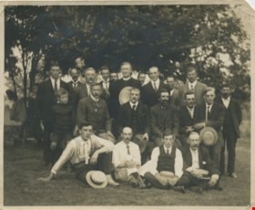
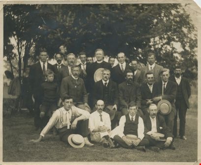
Burnaby Lake residents
https://search.heritageburnaby.ca/link/archivedescription34058
- Repository
- City of Burnaby Archives
- Date
- 1912
- Collection/Fonds
- Burnaby Historical Society fonds
- Description Level
- Item
- Physical Description
- 1 photograph : b&w ; 9.5 x 11.6 cm
- Scope and Content
- Photograph of a group of male Burnaby Lake residents posed outside near Deer Lake Drive. Identified, standing: B.R. Hill (3rd from left), Rev. D. Dunlop (6th from left), Harry Ramsay (8th from left), Louis "Edgar" Sprott (9th from left), and George Every-Clayton (10th from left). Sitting on bench…
- Repository
- City of Burnaby Archives
- Date
- 1912
- Collection/Fonds
- Burnaby Historical Society fonds
- Subseries
- Photographs subseries
- Physical Description
- 1 photograph : b&w ; 9.5 x 11.6 cm
- Description Level
- Item
- Record No.
- 003-001
- Access Restriction
- No restrictions
- Reproduction Restriction
- No known restrictions
- Accession Number
- BHS2007-04
- Scope and Content
- Photograph of a group of male Burnaby Lake residents posed outside near Deer Lake Drive. Identified, standing: B.R. Hill (3rd from left), Rev. D. Dunlop (6th from left), Harry Ramsay (8th from left), Louis "Edgar" Sprott (9th from left), and George Every-Clayton (10th from left). Sitting on bench: [first name unknown] Clayton (1st from left), Robert Pontifex (2nd from left), Mr. Clay (4th from left), and Frank Hill (6th from left). Sitting on ground: Claude Hill (1st from left) and Percy Boyer Brown (2nd from left).
- Names
- Brown, Percy Boyer
- Every-Clayton, George
- Dunlop, Rev. D.
- Hill, Bernard R.
- Hill, Frank
- Brown, Alex
- Hill, Louis Claude "Claude"
- Pontifex, Robert
- Ramsay, Harry
- Sprott, Louis "Edgar"
- Media Type
- Photograph
- Notes
- Title based on contents of photograph
- Identification key accompanying in the envelope for photo 003-001 (labeled BHS 3.1)
- Geographic Access
- Deer Lake
- Deer Lake Avenue
- Historic Neighbourhood
- Vancouver Heights (Historic Neighbourhood)
- Burnaby Lake (Historic Neighbourhood)
- Planning Study Area
- Douglas-Gilpin Area
Images

Loading Strawberries, BCERy, Douglas Road, Burnaby BC
https://search.heritageburnaby.ca/link/archivedescription66211
- Repository
- City of Burnaby Archives
- Date
- 1894
- Collection/Fonds
- Peers Family and Hill Family fonds
- Description Level
- Item
- Physical Description
- 1 photograph : b&w ; 13 x 18 cm on cardboard 22 x 27.5 cm
- Scope and Content
- Photograph of a group of farmers loading their crates onto a railway car. Identified (left to right), Bernard R. Hill, Louis Claude Hill, Charles Frederick Sprott, George E. Clayton, and Louis "Edgar" Sprott, who are loading up their strawberries on a street car. The farmers are lined up in a row,…
- Repository
- City of Burnaby Archives
- Date
- 1894
- Collection/Fonds
- Peers Family and Hill Family fonds
- Physical Description
- 1 photograph : b&w ; 13 x 18 cm on cardboard 22 x 27.5 cm
- Description Level
- Item
- Record No.
- 477-938
- Access Restriction
- No restrictions
- Reproduction Restriction
- No known restrictions
- Accession Number
- 2007-12
- Scope and Content
- Photograph of a group of farmers loading their crates onto a railway car. Identified (left to right), Bernard R. Hill, Louis Claude Hill, Charles Frederick Sprott, George E. Clayton, and Louis "Edgar" Sprott, who are loading up their strawberries on a street car. The farmers are lined up in a row, each sitting in their own horse and cart as they bring their strawberries to the station.
- Subjects
- Agriculture - Fruit and Berries
- Transportation - Electric Railroads
- Transportation - Horses
- Transportation - Carts
- Occupations - Farmers
- Transportation - Wagons
- Officials - Mayors and Reeves
- Names
- British Columbia Electric Railway Company
- Hill, Louis Claude "Claude"
- Hill, Bernard R.
- Every-Clayton, George
- Sprott, Louis "Edgar"
- Sprott, Charles Frederick
- Media Type
- Photograph
- Notes
- Title based on contents of photograph
- Caption on recto of photograph reads: "Loading Strawberries, B.C.E.Ry., Douglas Rd., Burnaby, B.C."
- Geographic Access
- Douglas Road
- Historic Neighbourhood
- Burnaby Lake (Historic Neighbourhood)
Images

, copied 1978 thumbnail](/media/hpo/_Data/_BVM_Images/1977/197800010009.jpg?width=280)
Mr. and Mrs. Edgar Sprott
https://search.heritageburnaby.ca/link/museumdescription455
- Repository
- Burnaby Village Museum
- Date
- [190-](date of original), copied 1978
- Collection/Fonds
- Burnaby Village Museum Photograph collection
- Description Level
- Item
- Physical Description
- 1 photograph : b&w ; 20.2 x 25.2 cm print
- Scope and Content
- Photograph of a young couple sitting on a felled tree on land that is being cleared. There are upturned trees, stumps, etc. The woman is wearing a coat with leg-o-mutton sleeves and a flat brimmed hat, and the man is in three piece suit, and has a pocket watch. An earlier catalogue record identifie…
- Repository
- Burnaby Village Museum
- Collection/Fonds
- Burnaby Village Museum Photograph collection
- Description Level
- Item
- Physical Description
- 1 photograph : b&w ; 20.2 x 25.2 cm print
- Scope and Content
- Photograph of a young couple sitting on a felled tree on land that is being cleared. There are upturned trees, stumps, etc. The woman is wearing a coat with leg-o-mutton sleeves and a flat brimmed hat, and the man is in three piece suit, and has a pocket watch. An earlier catalogue record identifies the couple as Mr. and Mrs. Edgar Sprott, on the land that is being cleared for their home, "Mayfield." The lake in the background is identified as Burnaby Lake.
- Subjects
- Land Clearing
- Plants - Trees
- Geographic Access
- Canada Way
- Burnaby Lake
- Accession Code
- HV978.1.9
- Access Restriction
- No restrictions
- Reproduction Restriction
- No known restrictions
- Date
- [190-](date of original), copied 1978
- Media Type
- Photograph
- Historic Neighbourhood
- Burnaby Lake (Historic Neighbourhood)
- Planning Study Area
- Morley-Buckingham Area
- Scan Resolution
- 600
- Scan Date
- 2023-08-01
- Notes
- Title based on contents of photograph
Images
, copied 1978 thumbnail](/media/hpo/_Data/_BVM_Images/1977/197800010009.jpg)
, copied 1978 thumbnail](/media/hpo/_Data/_BVM_Images/1977/197800010013.jpg?width=280)
Sprott family on the porch
https://search.heritageburnaby.ca/link/museumdescription459
- Repository
- Burnaby Village Museum
- Date
- [190-](date of original), copied 1978
- Collection/Fonds
- Burnaby Village Museum Photograph collection
- Description Level
- Item
- Physical Description
- 1 photograph : b&w ; 25.2 x 20.2 cm print
- Scope and Content
- Photograph of people on the porch of the Charles F. Sprott house at Norland Avenue at Douglas Road . There are two men and three women standing on the top step of the porch and a man sitting on the bottom step. A catalogue record from 1978 identifes the people standing on the step as (l to r) Aunt …
- Repository
- Burnaby Village Museum
- Collection/Fonds
- Burnaby Village Museum Photograph collection
- Description Level
- Item
- Physical Description
- 1 photograph : b&w ; 25.2 x 20.2 cm print
- Scope and Content
- Photograph of people on the porch of the Charles F. Sprott house at Norland Avenue at Douglas Road . There are two men and three women standing on the top step of the porch and a man sitting on the bottom step. A catalogue record from 1978 identifes the people standing on the step as (l to r) Aunt Lucy, Mrs. E. Sprott, Mr. Edgar Sprott, and Great Aunt and Great Uncle (who stayed for a while with the Sprotts). The seated man is unidentified.
- Geographic Access
- Douglas Road
- Norland Avenue
- Accession Code
- HV978.1.13
- Access Restriction
- No restrictions
- Reproduction Restriction
- No known restrictions
- Date
- [190-](date of original), copied 1978
- Media Type
- Photograph
- Historic Neighbourhood
- Burnaby Lake (Historic Neighbourhood)
- Scan Resolution
- 600
- Scan Date
- 2023-08-01
- Notes
- Title based on contents of photograph
Images
, copied 1978 thumbnail](/media/hpo/_Data/_BVM_Images/1977/197800010013.jpg)
, copied 1978 thumbnail](/media/hpo/_Data/_BVM_Images/1977/197800010015.jpg?width=280)
Sprott family on the porch
https://search.heritageburnaby.ca/link/museumdescription461
- Repository
- Burnaby Village Museum
- Date
- [190-](date of original), copied 1978
- Collection/Fonds
- Burnaby Village Museum Photograph collection
- Description Level
- Item
- Physical Description
- 1 photograph : b&w ; 20.2 x 25.2 cm print
- Scope and Content
- Photograph of a group of people on the porch of a house. There are six men, three women and three girls standing on the top step of the porch. A catalogue record from 1978 identifies some of the people standing on the porch, however, not very precisely. Standing to the left of the group is Charle…
- Repository
- Burnaby Village Museum
- Collection/Fonds
- Burnaby Village Museum Photograph collection
- Description Level
- Item
- Physical Description
- 1 photograph : b&w ; 20.2 x 25.2 cm print
- Scope and Content
- Photograph of a group of people on the porch of a house. There are six men, three women and three girls standing on the top step of the porch. A catalogue record from 1978 identifies some of the people standing on the porch, however, not very precisely. Standing to the left of the group is Charles Sprott. Beside him are Mr. and Mrs. Edgar Sprott. Depicted to the right of the picture, there are Charles's wife Lucy Schou Sprott, Muriel Sprott, Kitty Hill [?], and Helen Sprott [?]. Charles Sprott was Reeve of Burnaby from 1904 to 1905. He was also a member of Council from 1895 to 1904 and in 1907.
- Names
- Peers, Katherine Maude Hill "Kitty"
- Sprott, Charles Frederick
- Sprott, Louis "Edgar"
- Sprott, Helen Fanny
- Sprott, Helen Louise Faith Nicholls
- Sprott, Muriel
- Sprott, Lucy Christine Schou
- Accession Code
- HV978.1.15
- Access Restriction
- No restrictions
- Reproduction Restriction
- No known restrictions
- Date
- [190-](date of original), copied 1978
- Media Type
- Photograph
- Historic Neighbourhood
- Burnaby Lake (Historic Neighbourhood)
- Scan Resolution
- 600
- Scan Date
- 2023-08-01
- Notes
- Title based on contents of photograph
Images
, copied 1978 thumbnail](/media/hpo/_Data/_BVM_Images/1977/197800010015.jpg)