More like 'Salmon Send Off'
Narrow Results By
Subject
- Accidents 1
- Accidents - Automobile Accidents 11
- Advertising Medium 1
- Advertising Medium - Poster 1
- Advertising Medium - Signs and Signboards 45
- Aerial Photographs 26
- Agricultural Tools and Equipment 10
- Agricultural Tools and Equipment - Gardening Equipment 4
- Agricultural Tools and Equipment - Plows 5
- Agriculture 8
- Agriculture - Crops 15
- Agriculture - Farms 86
![Beaver Creek salmon release, [2001] thumbnail](/media/hpo/_Data/_Archives_Images/_Unrestricted/535/535-2497.jpg?width=280)
Beaver Creek salmon release
https://search.heritageburnaby.ca/link/archivedescription96942
- Repository
- City of Burnaby Archives
- Date
- [2001]
- Collection/Fonds
- Burnaby NewsLeader photograph collection
- Description Level
- Item
- Physical Description
- 1 photograph (tiff) : col.
- Scope and Content
- Photograph of Gail McGrath holding up a plastic bag containing water and Coho salmon fry were released into Beaver Creek during Environment Week celebrations at Deer Lake Park.
- Repository
- City of Burnaby Archives
- Date
- [2001]
- Collection/Fonds
- Burnaby NewsLeader photograph collection
- Physical Description
- 1 photograph (tiff) : col.
- Description Level
- Item
- Record No.
- 535-2497
- Access Restriction
- No restrictions
- Reproduction Restriction
- No restrictions
- Accession Number
- 2018-12
- Scope and Content
- Photograph of Gail McGrath holding up a plastic bag containing water and Coho salmon fry were released into Beaver Creek during Environment Week celebrations at Deer Lake Park.
- Media Type
- Photograph
- Photographer
- Bartel, Mario
- Notes
- Title based on caption
- Collected by editorial for use in a June 2001 issue of the Burnaby NewsLeader
- Caption from metadata: "Gail McGrath gets a close-up look at some of the 3,000 Coho fry that were released into Beaver Creek last Saturday as part of Burnaby's Environment Week celebrations at Deer Lake Park. The fry will leave the creek next May, as 20 gram smolts, heading to the Fraser River via Deer Lake, Burnaby Lake, and the Brunette River. Of the 3,000, one pair may return to the creek as spawning adults. "
- Geographic Access
- Deer Lake Park
- Deer Lake
- Historic Neighbourhood
- Burnaby Lake (Historic Neighbourhood)
- Planning Study Area
- Oakalla Area
Images
![Beaver Creek salmon release, [2001] thumbnail](/media/hpo/_Data/_Archives_Images/_Unrestricted/535/535-2497.jpg)
![Great Salmon Send Off, [2000] thumbnail](/media/hpo/_Data/_Archives_Images/_Unrestricted/535/535-2414.jpg?width=280)
Great Salmon Send Off
https://search.heritageburnaby.ca/link/archivedescription96856
- Repository
- City of Burnaby Archives
- Date
- [2000]
- Collection/Fonds
- Burnaby NewsLeader photograph collection
- Description Level
- Item
- Physical Description
- 1 photograph (tiff) : col.
- Scope and Content
- Photograph of Al Hunter and his child, Kyara, releasing Coho fingerlings into Stoney Creek at the Great Salmon Send Off.
- Repository
- City of Burnaby Archives
- Date
- [2000]
- Collection/Fonds
- Burnaby NewsLeader photograph collection
- Physical Description
- 1 photograph (tiff) : col.
- Description Level
- Item
- Record No.
- 535-2414
- Access Restriction
- No restrictions
- Reproduction Restriction
- No restrictions
- Accession Number
- 2018-12
- Scope and Content
- Photograph of Al Hunter and his child, Kyara, releasing Coho fingerlings into Stoney Creek at the Great Salmon Send Off.
- Media Type
- Photograph
- Photographer
- Bartel, Mario
- Notes
- Title based on caption
- Collected by editorial for use in a May 2000 issue of the Burnaby NewsLeader
- Caption from metadata: "Kyara Hunter, 4, gets a little help from her dad, Al, releasing Coho fingerlings into Stoney Creek, at the Great Salmon Send Off on Saturday. About 4,000 young Coho, raised by the Sapperton Fish and Game Club, were released into the stream."
- Geographic Access
- Stoney Creek
- Historic Neighbourhood
- Burquitlam (Historic Neighbourhood)
- Planning Study Area
- Lyndhurst Area
Images
![Great Salmon Send Off, [2000] thumbnail](/media/hpo/_Data/_Archives_Images/_Unrestricted/535/535-2414.jpg)
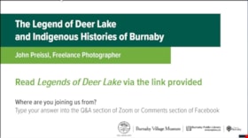
The Legend of Deer Lake and Indigenous histories of Burnaby
https://search.heritageburnaby.ca/link/museumdescription15666
- Repository
- Burnaby Village Museum
- Date
- 4 May 2021
- Collection/Fonds
- Burnaby Village Museum fonds
- Description Level
- Item
- Physical Description
- 1 video recording (mp4) (62 min., 28 sec.) : digital, col., sd., stereo ; 29 fps
- Scope and Content
- Item consists of a video recording of a live Zoom webinar hosted by Adrian Avendaño, Stewardship Program Manager with Still Moon Arts Society. The webinar is presented in partnership with the Burnaby Village Museum, Burnaby Public Library and Still Moon Arts Society. The webinar is titled "The Lege…
- Repository
- Burnaby Village Museum
- Collection/Fonds
- Burnaby Village Museum fonds
- Description Level
- Item
- Physical Description
- 1 video recording (mp4) (62 min., 28 sec.) : digital, col., sd., stereo ; 29 fps
- Material Details
- Presenter: John Preissl
- Host: Adrian Avendano (Still Moon Arts Society)
- Date of Presentation: Tuesday, May 4, 7:00 pm - 8:00 pm
- Total Number of tracks: 1
- Total Length of all tracks: 62 min., 28 sec.
- Recording Device: Zoom video communication platform
- Recording Note: Film was edited from it's original recorded version (77 min., 48 sec.) to edited version (62 min., 28 sec.) for public viewing on Heritage Burnaby.
- Scope and Content
- Item consists of a video recording of a live Zoom webinar hosted by Adrian Avendaño, Stewardship Program Manager with Still Moon Arts Society. The webinar is presented in partnership with the Burnaby Village Museum, Burnaby Public Library and Still Moon Arts Society. The webinar is titled "The Legend of Deer Lake and Indigenous histories of Burnaby" and is presented by John Preissl, Freelance Photographer of Sḵwx̱wú7mesh and Leq’á:mel Nation ancestry. The Zoom webinar is the third in a series of six "Neighbourhood Speaker series" webinars exploring a range of topics shared by Indigenous speakers and knowledge keepers that were presented and made available to the public between April 27 and May 12, 2021. The live webinar was also made available on the Burnaby Village Museum's facebook page. Community members were invited to participate by bringing questions during the interactive online sessions. This webinar was made available in In partnership with Still Moon Arts Society. In this webinar, John Preissl shares his family’s long history from the first Chief Capilano in the late 1700's to the present day. Looking through the lens of his camera, John weaves together stories of the Legend of Deer Lake, resource gathering in the Burnaby Lake Watershed, and protection of the sacred salmon and eagle habitat on the shared homelands of the hən̓q̓əmin̓əm and Sḵwx̱wú7mesh speaking peoples. The presentation is supported with photographs that John has taken over the years documenting the diverse environment and wildlife habitats in Burnaby, the lower mainland and west coast including waterways and the fight to protect it. Following the presentation, John Preissl takes questions from the audience that are moderated by the host, Adrian Avendaño.
- History
- John Preissl is a Burnaby-based environmental, adventure, wildlife and Indigenous freelance photographer. He is a media expert with over two decades of media experience and consulting. John is of Sḵwx̱wú7mesh and Leq’á:mel Nation ancestry. His Great times-two Grandfather was the Great Chief Joe Capilano. John leads many First Nations Tours in Burnaby from Deer Lake, Burnaby Lake, Burnaby Mountain and pretty well all over Sḵwx̱wú7mesh and Tsleil-Waututh Nations Lands.
- Subjects
- Indigenous peoples - British Columbia - Social life and customs
- Animals - Birds
- Animals - Fish
- Geographic Features - Lakes and Ponds
- Geographic Features - Ravines
- Names
- Preissl, John
- Tsleil-Waututh Nation
- Sḵwx̱wú7mesh Nation
- Avendaño, Adrian
- Burnaby Village Museum
- Accession Code
- BV021.17.3
- Access Restriction
- No restrictions
- Reproduction Restriction
- No known restrictions
- Date
- 4 May 2021
- Media Type
- Moving Images
- Historic Neighbourhood
- Burnaby Lake (Historic Neighbourhood)
- Planning Study Area
- Burnaby Lake Area
- Notes
- Title based on content of video recording The following links were shared at the end of the presentation:
- The Legend of Deer Lake: https://www.legendsofvancouver.net/deer-lake-burnaby-vancouver
- Saving the Salmon: the Brunette River Story, a short film about the preservation of Brunette River: https://search.heritageburnaby.ca/permalink/museumvideo4486
- Saving Burnaby Lake, a short film about the preservation of Burnaby Lake: https://search.heritageburnaby.ca/permalink/museumvideo4485
- Still Creek Streamkeepers: https://stillmoonarts.ca/stewardship/streamkeepers/
- John Preissl’s photography website: https://johnpreisslphotography.ca/
Images
Video
The Legend of Deer Lake and Indigenous histories of Burnaby, 4 May 2021
The Legend of Deer Lake and Indigenous histories of Burnaby, 4 May 2021
https://search.heritageburnaby.ca/media/hpo/_Data/_BVM_Moving_Images/2021_0017_0003_002.mp4![Intake of Burnaby's water supply, [190-?] (date of original), copied 1977 thumbnail](/media/hpo/_Data/_BVM_Images/1977/1977_0099_0025_001.jpg?width=280)
Intake of Burnaby's water supply
https://search.heritageburnaby.ca/link/museumdescription583
- Repository
- Burnaby Village Museum
- Date
- [190-?] (date of original), copied 1977
- Collection/Fonds
- Burnaby Village Museum Photograph collection
- Description Level
- Item
- Physical Description
- 1 photograph : b&w ; 20.2 x 25.2 cm print
- Scope and Content
- Photograph of a building by fast flowing stream. There are dense forests to both sides of the photograph, and mountains in the distance. Three men in suits and ties are standing by the house. The catalogue record identifies the photograph as "intake of Burnaby's water supply," and also notes "Bruce…
- Repository
- Burnaby Village Museum
- Collection/Fonds
- Burnaby Village Museum Photograph collection
- Description Level
- Item
- Physical Description
- 1 photograph : b&w ; 20.2 x 25.2 cm print
- Scope and Content
- Photograph of a building by fast flowing stream. There are dense forests to both sides of the photograph, and mountains in the distance. Three men in suits and ties are standing by the house. The catalogue record identifies the photograph as "intake of Burnaby's water supply," and also notes "Bruce Patterson took this picture."
- Accession Code
- HV977.99.25
- Access Restriction
- No restrictions
- Reproduction Restriction
- May be restricted by third party rights
- Date
- [190-?] (date of original), copied 1977
- Media Type
- Photograph
- Scan Resolution
- 600
- Scan Date
- 2023-07-18
- Photographer
- Patterson, Bruce
- Notes
- Title based on catalogue record
Images
![Intake of Burnaby's water supply, [190-?] (date of original), copied 1977 thumbnail](/media/hpo/_Data/_BVM_Images/1977/1977_0099_0025_001.jpg)
![Cariboo Dam fish weir, [2002] thumbnail](/media/hpo/_Data/_Archives_Images/_Unrestricted/535/535-2996.jpg?width=280)
Cariboo Dam fish weir
https://search.heritageburnaby.ca/link/archivedescription97722
- Repository
- City of Burnaby Archives
- Date
- [2002]
- Collection/Fonds
- Burnaby NewsLeader photograph collection
- Description Level
- Item
- Physical Description
- 1 photograph (tiff) : col.
- Scope and Content
- Photograph of Elmer Rudolph and Bob Henderson helping a salmon through the fish weir at the Cariboo Dam on the Brunette River.
- Repository
- City of Burnaby Archives
- Date
- [2002]
- Collection/Fonds
- Burnaby NewsLeader photograph collection
- Physical Description
- 1 photograph (tiff) : col.
- Description Level
- Item
- Record No.
- 535-2996
- Access Restriction
- No restrictions
- Reproduction Restriction
- No restrictions
- Accession Number
- 2018-12
- Scope and Content
- Photograph of Elmer Rudolph and Bob Henderson helping a salmon through the fish weir at the Cariboo Dam on the Brunette River.
- Media Type
- Photograph
- Photographer
- Bartel, Mario
- Notes
- Title based on caption
- Collected by editorial for use in a November 2002 issue of the Burnaby NewsLeader
- Caption from metadata: "Elmer Rudolph and Bob Henderson help a mature female salmon, weighing about nine pounds, up through the fish weir at the Cariboo dam. The week of heavy rain has finally made conditions favorable for fish to make their journey up the Brunette River from the Fraser, and then on to their spawning beds, and Rudolph is at the dam every day to help them along. On Saturday, in addition to the mature salmon, he also helped four immature males and two 14-inch Cutthroat."
- Geographic Access
- Burnaby Lake
- Brunette River
- Historic Neighbourhood
- Burnaby Lake (Historic Neighbourhood)
- Planning Study Area
- Burnaby Lake Area
Images
![Cariboo Dam fish weir, [2002] thumbnail](/media/hpo/_Data/_Archives_Images/_Unrestricted/535/535-2996.jpg)
Saving the Salmon: the Brunette River Story
https://search.heritageburnaby.ca/link/museumdescription4486
- Repository
- Burnaby Village Museum
- Date
- 2018
- Collection/Fonds
- Burnaby Village Museum fonds
- Description Level
- Item
- Physical Description
- 1 video recording (mp4) (3 min., 35 sec.) : digital, 23 fps, col., sd., stereo
- Scope and Content
- This short film was produced by the City of Burnaby Community Heritage Commission to commemorate Burnaby's 125th anniversary. It features the story of the preservation of the Brunette River.
- Repository
- Burnaby Village Museum
- Collection/Fonds
- Burnaby Village Museum fonds
- Description Level
- Item
- Physical Description
- 1 video recording (mp4) (3 min., 35 sec.) : digital, 23 fps, col., sd., stereo
- Scope and Content
- This short film was produced by the City of Burnaby Community Heritage Commission to commemorate Burnaby's 125th anniversary. It features the story of the preservation of the Brunette River.
- Publisher
- City of Burnaby
- Other Title Information
- title given by film makers
- Accession Code
- BV018.12.4
- Access Restriction
- No restrictions
- Reproduction Restriction
- May be restricted by third party rights
- Date
- 2018
- Media Type
- Moving Images
- Planning Study Area
- Burnaby Lake Area
- Notes
- Transcribed title
- Reproduction of content is restricted
Images
Video
Saving the Salmon: the Brunette River Story, 2018
Saving the Salmon: the Brunette River Story, 2018
https://search.heritageburnaby.ca/media/hpo/_Data/_BVM_Moving_Images/2018_0012_0004_001.mp4
Opening of the Hastings-Barnet Road
https://search.heritageburnaby.ca/link/archivedescription38660
- Repository
- City of Burnaby Archives
- Date
- 1927
- Collection/Fonds
- Burnaby Historical Society fonds
- Description Level
- Item
- Physical Description
- 1 photograph : sepia ; 17.5 x 26.5 cm
- Scope and Content
- Photograph of the official opening of the newly paved Hastings-Barnet Road which opened on Saturday December 10, 1927. In the foreground the Provincial Minister of Public Works Dr. W.H. Sutherland is opening a wooden gate, with a large crowd gathered around. The Barnet Lumber Company Ltd. building …
- Repository
- City of Burnaby Archives
- Date
- 1927
- Collection/Fonds
- Burnaby Historical Society fonds
- Subseries
- North Burnaby Board of Trade subseries
- Physical Description
- 1 photograph : sepia ; 17.5 x 26.5 cm
- Description Level
- Item
- Record No.
- 476-003
- Access Restriction
- No restrictions
- Reproduction Restriction
- No known restrictions
- Accession Number
- BHS2005-8
- Scope and Content
- Photograph of the official opening of the newly paved Hastings-Barnet Road which opened on Saturday December 10, 1927. In the foreground the Provincial Minister of Public Works Dr. W.H. Sutherland is opening a wooden gate, with a large crowd gathered around. The Barnet Lumber Company Ltd. building on Hastings Street is in the background.
- Subjects
- Geographic Features - Roads
- Persons - Crowds
- Buildings - Industrial - Mills
- Officials - Elected Officials
- Public Services - Public Works
- Names
- Barnet Mill
- Sutherland, W.H.
- Media Type
- Photograph
- Notes
- Title based on contents of photograph
- Geographic Access
- Hastings Street
- Street Address
- 3995 Hastings Street
- Historic Neighbourhood
- Vancouver Heights (Historic Neighbourhood)
- Planning Study Area
- Burnaby Heights Area
Images

![Anthony Ferrari tree planting in Beecher Park, [2002] thumbnail](/media/hpo/_Data/_Archives_Images/_Unrestricted/535/535-2842.jpg?width=280)
Anthony Ferrari tree planting in Beecher Park
https://search.heritageburnaby.ca/link/archivedescription97503
- Repository
- City of Burnaby Archives
- Date
- [2002]
- Collection/Fonds
- Burnaby NewsLeader photograph collection
- Description Level
- Item
- Physical Description
- 1 photograph (tiff) : col.
- Scope and Content
- Photograph of Anthony Ferrari, an athlete with the Burnaby Winter Club AAA Bantams hockey team, planting vegetation during an environmental event with the Toronto Dominion Bank in Beecher Park.
- Repository
- City of Burnaby Archives
- Date
- [2002]
- Collection/Fonds
- Burnaby NewsLeader photograph collection
- Physical Description
- 1 photograph (tiff) : col.
- Description Level
- Item
- Record No.
- 535-2842
- Access Restriction
- No restrictions
- Reproduction Restriction
- No restrictions
- Accession Number
- 2018-12
- Scope and Content
- Photograph of Anthony Ferrari, an athlete with the Burnaby Winter Club AAA Bantams hockey team, planting vegetation during an environmental event with the Toronto Dominion Bank in Beecher Park.
- Subjects
- Persons - Athletes
- Environmental Issues
- Geographic Features - Creeks
- Geographic Features - Forests
- Names
- Burnaby Winter Club
- Media Type
- Photograph
- Photographer
- Bartel, Mario
- Notes
- Title based on caption
- Collected by editorial for use in a November 2002 issue of the Burnaby NewsLeader
- Caption from metadata: "Anthony Ferrari , a player with the Burnaby Winter Club AAA Bantams, does his part to help restore the natural habitat around Beecher Creek. Members of the team joined staff from the Toronto Dominion Bank Saturday to plant trees and native vegetation in the ongoing effort to maintain the creek as a home for fish as it passes through Beecher Park."
- Geographic Access
- Beecher Park
- Springer Avenue
- Street Address
- 1255 Springer Avenue
- Planning Study Area
- Brentwood Area
Images
![Anthony Ferrari tree planting in Beecher Park, [2002] thumbnail](/media/hpo/_Data/_Archives_Images/_Unrestricted/535/535-2842.jpg)
![Dover Street crosswalk lights, [2000] thumbnail](/media/hpo/_Data/_Archives_Images/_Unrestricted/535/535-2540.jpg?width=280)
Dover Street crosswalk lights
https://search.heritageburnaby.ca/link/archivedescription97008
- Repository
- City of Burnaby Archives
- Date
- [2000]
- Collection/Fonds
- Burnaby NewsLeader photograph collection
- Description Level
- Item
- Physical Description
- 1 photograph (tiff) : col.
- Scope and Content
- Photograph of the assistant director of traffic engineering at the City of Burnaby examining a piece of equipment installed in Dover Street as part of a pilot project for new crosswalk lights. A school crosswalk sign and passing vehicle are visible in the background.
- Repository
- City of Burnaby Archives
- Date
- [2000]
- Collection/Fonds
- Burnaby NewsLeader photograph collection
- Physical Description
- 1 photograph (tiff) : col.
- Description Level
- Item
- Record No.
- 535-2540
- Access Restriction
- No restrictions
- Reproduction Restriction
- No restrictions
- Accession Number
- 2018-12
- Scope and Content
- Photograph of the assistant director of traffic engineering at the City of Burnaby examining a piece of equipment installed in Dover Street as part of a pilot project for new crosswalk lights. A school crosswalk sign and passing vehicle are visible in the background.
- Subjects
- Geographic Features - Roads
- Geographic Features - Sidewalks
- Occupations - Civic Workers
- Public Services - Public Works
- Media Type
- Photograph
- Photographer
- Bartel, Mario
- Notes
- Title based on caption
- Collected by editorial for use in a July 2000 issue of the Burnaby NewsLeader
- Caption from metadata: "Burnaby's assistand director of traffic engineering examines the new crosswalk lights, installed as a pilot project, on Dover, between Royal Oak and Nelson."
- Geographic Access
- Dover Street
- Nelson Avenue
- Royal Oak Avenue
- Historic Neighbourhood
- Central Park (Historic Neighbourhood)
- Planning Study Area
- Marlborough Area
Images
![Dover Street crosswalk lights, [2000] thumbnail](/media/hpo/_Data/_Archives_Images/_Unrestricted/535/535-2540.jpg)
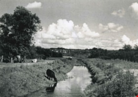
Still Creek
https://search.heritageburnaby.ca/link/archivedescription36537
- Repository
- City of Burnaby Archives
- Date
- 1935
- Collection/Fonds
- Burnaby Historical Society fonds
- Description Level
- Item
- Physical Description
- 1 photograph : b&w ; 11.5 x 16.5 cm print
- Scope and Content
- Photograph of a cow taking a drink from Still Creek, east of Willingdon Avenue. Other cows are visible lying in the sun and grazing in the grass on the left.
- Repository
- City of Burnaby Archives
- Date
- 1935
- Collection/Fonds
- Burnaby Historical Society fonds
- Subseries
- Photographs subseries
- Physical Description
- 1 photograph : b&w ; 11.5 x 16.5 cm print
- Description Level
- Item
- Record No.
- 291-001
- Access Restriction
- No restrictions
- Reproduction Restriction
- No known restrictions
- Accession Number
- BHS1992-28
- Scope and Content
- Photograph of a cow taking a drink from Still Creek, east of Willingdon Avenue. Other cows are visible lying in the sun and grazing in the grass on the left.
- Names
- Still Creek
- Media Type
- Photograph
- Photographer
- Simpson, Walter E.
- Notes
- Title based on contents of photograph
- Geographic Access
- Still Creek
- Historic Neighbourhood
- Broadview (Historic Neighbourhood)
- Planning Study Area
- West Central Valley Area
Images

Deer Lake Gibraltar
https://search.heritageburnaby.ca/link/archivedescription34312
- Repository
- City of Burnaby Archives
- Date
- 1924
- Collection/Fonds
- Burnaby Historical Society fonds
- Description Level
- Item
- Physical Description
- 1 photograph : b&w ; 8.1 x 13.2 cm
- Scope and Content
- Photograph of the "Gibraltar" rock at mouth of Deer Lake Creek. This photograph was taken during the winter of 1924 and the lake is frozen over with ice. The surface of the lake is covered with marks made by ice skates. Deer Lake Creek is historically known as Deer Lake Brook.
- Repository
- City of Burnaby Archives
- Date
- 1924
- Collection/Fonds
- Burnaby Historical Society fonds
- Subseries
- Peers family subseries
- Physical Description
- 1 photograph : b&w ; 8.1 x 13.2 cm
- Description Level
- Item
- Record No.
- 020-019
- Access Restriction
- No restrictions
- Reproduction Restriction
- No known restrictions
- Accession Number
- BHS2007-04
- Scope and Content
- Photograph of the "Gibraltar" rock at mouth of Deer Lake Creek. This photograph was taken during the winter of 1924 and the lake is frozen over with ice. The surface of the lake is covered with marks made by ice skates. Deer Lake Creek is historically known as Deer Lake Brook.
- Subjects
- Geographic Features - Creeks
- Geographic Features - Lakes and Ponds
- Geographic Features - Rock Formations
- Media Type
- Photograph
- Notes
- Title based on caption accompanying photograph
- Geographic Access
- Deer Lake Brook
- Historic Neighbourhood
- Burnaby Lake (Historic Neighbourhood)
- Planning Study Area
- Morley-Buckingham Area
Images


Burnaby's COVID-19 drive thru testing site
https://search.heritageburnaby.ca/link/museumdescription15374
- Repository
- Burnaby Village Museum
- Date
- 5 Apr. 2020
- Collection/Fonds
- Burnaby Village Museum COVID-19 collection
- Description Level
- Item
- Physical Description
- 1 photograph (jpg)
- Scope and Content
- Photograph of the COVID-19 drive thru testing site in Central Park parking lot in Burnaby. Orange traffic posts and wayfinding signs are set up in the parking lot.
- Repository
- Burnaby Village Museum
- Collection/Fonds
- Burnaby Village Museum COVID-19 collection
- Description Level
- Item
- Physical Description
- 1 photograph (jpg)
- Scope and Content
- Photograph of the COVID-19 drive thru testing site in Central Park parking lot in Burnaby. Orange traffic posts and wayfinding signs are set up in the parking lot.
- Subjects
- Advertising Medium - Signs and Signboards
- Geographic Features - Parks
- Public Services - Health Services
- Pandemics - COVID-19
- Geographic Access
- Central Park
- Imperial Street
- Accession Code
- BV021.2.39
- Access Restriction
- No restrictions
- Reproduction Restriction
- May be restricted by third party rights
- Date
- 5 Apr. 2020
- Media Type
- Photograph
- Historic Neighbourhood
- Central Park (Historic Neighbourhood)
- Planning Study Area
- Maywood Area
- Notes
- Title based on contents of photograph
Images


Burnaby's COVID-19 drive thru testing site
https://search.heritageburnaby.ca/link/museumdescription15375
- Repository
- Burnaby Village Museum
- Date
- 5 Apr. 2020
- Collection/Fonds
- Burnaby Village Museum COVID-19 collection
- Description Level
- Item
- Physical Description
- 1 photograph (jpg)
- Scope and Content
- Photograph of the COVID-19 drive thru testing site in Central Park parking lot in Burnaby. Orange traffic posts, wayfinding signs and white tents are set up in the parking lot.
- Repository
- Burnaby Village Museum
- Collection/Fonds
- Burnaby Village Museum COVID-19 collection
- Description Level
- Item
- Physical Description
- 1 photograph (jpg)
- Scope and Content
- Photograph of the COVID-19 drive thru testing site in Central Park parking lot in Burnaby. Orange traffic posts, wayfinding signs and white tents are set up in the parking lot.
- Subjects
- Advertising Medium - Signs and Signboards
- Geographic Features - Parks
- Public Services - Health Services
- Pandemics - COVID-19
- Geographic Access
- Central Park
- Imperial Street
- Accession Code
- BV021.2.40
- Access Restriction
- No restrictions
- Reproduction Restriction
- May be restricted by third party rights
- Date
- 5 Apr. 2020
- Media Type
- Photograph
- Historic Neighbourhood
- Central Park (Historic Neighbourhood)
- Planning Study Area
- Maywood Area
- Notes
- Title based on contents of photograph
Images


Burnaby's COVID-19 drive thru testing site
https://search.heritageburnaby.ca/link/museumdescription15376
- Repository
- Burnaby Village Museum
- Date
- 5 Apr. 2020
- Collection/Fonds
- Burnaby Village Museum COVID-19 collection
- Description Level
- Item
- Physical Description
- 1 photograph (jpg)
- Scope and Content
- Photograph of the COVID-19 drive thru testing site in Central Park parking lot in Burnaby. Orange traffic posts, wayfinding signs and white tents are set up in the parking lot.
- Repository
- Burnaby Village Museum
- Collection/Fonds
- Burnaby Village Museum COVID-19 collection
- Description Level
- Item
- Physical Description
- 1 photograph (jpg)
- Scope and Content
- Photograph of the COVID-19 drive thru testing site in Central Park parking lot in Burnaby. Orange traffic posts, wayfinding signs and white tents are set up in the parking lot.
- Subjects
- Advertising Medium - Signs and Signboards
- Geographic Features - Parks
- Public Services - Health Services
- Pandemics - COVID-19
- Geographic Access
- Central Park
- Imperial Street
- Accession Code
- BV021.2.41
- Access Restriction
- No restrictions
- Reproduction Restriction
- May be restricted by third party rights
- Date
- 5 Apr. 2020
- Media Type
- Photograph
- Historic Neighbourhood
- Central Park (Historic Neighbourhood)
- Planning Study Area
- Maywood Area
- Notes
- Title based on contents of photograph
Images


Burnaby's COVID-19 drive thru testing site
https://search.heritageburnaby.ca/link/museumdescription15377
- Repository
- Burnaby Village Museum
- Date
- 5 Apr. 2020
- Collection/Fonds
- Burnaby Village Museum COVID-19 collection
- Description Level
- Item
- Physical Description
- 1 photograph (jpg)
- Scope and Content
- Photograph of the COVID-19 drive thru testing site in Central Park parking lot in Burnaby. Orange traffic posts, wayfinding signs and white tents are set up in the parking lot.
- Repository
- Burnaby Village Museum
- Collection/Fonds
- Burnaby Village Museum COVID-19 collection
- Description Level
- Item
- Physical Description
- 1 photograph (jpg)
- Scope and Content
- Photograph of the COVID-19 drive thru testing site in Central Park parking lot in Burnaby. Orange traffic posts, wayfinding signs and white tents are set up in the parking lot.
- Subjects
- Advertising Medium - Signs and Signboards
- Geographic Features - Parks
- Public Services - Health Services
- Pandemics - COVID-19
- Geographic Access
- Central Park
- Imperial Street
- Accession Code
- BV021.2.42
- Access Restriction
- No restrictions
- Reproduction Restriction
- May be restricted by third party rights
- Date
- 5 Apr. 2020
- Media Type
- Photograph
- Historic Neighbourhood
- Central Park (Historic Neighbourhood)
- Planning Study Area
- Maywood Area
- Notes
- Title based on contents of photograph
Images


Burnaby's COVID-19 drive thru testing site
https://search.heritageburnaby.ca/link/museumdescription15378
- Repository
- Burnaby Village Museum
- Date
- 5 Apr. 2020
- Collection/Fonds
- Burnaby Village Museum COVID-19 collection
- Description Level
- Item
- Physical Description
- 1 photograph (jpg)
- Scope and Content
- Photograph of the COVID-19 drive thru testing site in Central Park parking lot in Burnaby. Orange traffic posts, wayfinding signs and white tents are set up in the parking lot.
- Repository
- Burnaby Village Museum
- Collection/Fonds
- Burnaby Village Museum COVID-19 collection
- Description Level
- Item
- Physical Description
- 1 photograph (jpg)
- Scope and Content
- Photograph of the COVID-19 drive thru testing site in Central Park parking lot in Burnaby. Orange traffic posts, wayfinding signs and white tents are set up in the parking lot.
- Subjects
- Advertising Medium - Signs and Signboards
- Geographic Features - Parks
- Public Services - Health Services
- Pandemics - COVID-19
- Geographic Access
- Central Park
- Imperial Street
- Accession Code
- BV021.2.43
- Access Restriction
- No restrictions
- Reproduction Restriction
- May be restricted by third party rights
- Date
- 5 Apr. 2020
- Media Type
- Photograph
- Historic Neighbourhood
- Central Park (Historic Neighbourhood)
- Planning Study Area
- Maywood Area
- Notes
- Title based on contents of photograph
Images


Burnaby's COVID-19 drive thru testing site
https://search.heritageburnaby.ca/link/museumdescription15379
- Repository
- Burnaby Village Museum
- Date
- 5 Apr. 2020
- Collection/Fonds
- Burnaby Village Museum COVID-19 collection
- Description Level
- Item
- Physical Description
- 1 photograph (jpg)
- Scope and Content
- Photograph of the COVID-19 drive thru testing site in Central Park parking lot in Burnaby. Orange traffic posts, wayfinding signs, white tents and white buildings converted from shipping containers are set up in the parking lot.
- Repository
- Burnaby Village Museum
- Collection/Fonds
- Burnaby Village Museum COVID-19 collection
- Description Level
- Item
- Physical Description
- 1 photograph (jpg)
- Scope and Content
- Photograph of the COVID-19 drive thru testing site in Central Park parking lot in Burnaby. Orange traffic posts, wayfinding signs, white tents and white buildings converted from shipping containers are set up in the parking lot.
- Subjects
- Advertising Medium - Signs and Signboards
- Geographic Features - Parks
- Public Services - Health Services
- Pandemics - COVID-19
- Geographic Access
- Central Park
- Imperial Street
- Accession Code
- BV021.2.44
- Access Restriction
- No restrictions
- Reproduction Restriction
- May be restricted by third party rights
- Date
- 5 Apr. 2020
- Media Type
- Photograph
- Historic Neighbourhood
- Central Park (Historic Neighbourhood)
- Planning Study Area
- Maywood Area
- Notes
- Title based on contents of photograph
Images


Burnaby's COVID-19 drive thru testing site
https://search.heritageburnaby.ca/link/museumdescription15380
- Repository
- Burnaby Village Museum
- Date
- 5 Apr. 2020
- Collection/Fonds
- Burnaby Village Museum COVID-19 collection
- Description Level
- Item
- Physical Description
- 1 photograph (jpg)
- Scope and Content
- Photograph of the COVID-19 drive thru testing site in Central Park parking lot in Burnaby. Orange traffic posts, wayfinding signs and white tents are set up in the parking lot.
- Repository
- Burnaby Village Museum
- Collection/Fonds
- Burnaby Village Museum COVID-19 collection
- Description Level
- Item
- Physical Description
- 1 photograph (jpg)
- Scope and Content
- Photograph of the COVID-19 drive thru testing site in Central Park parking lot in Burnaby. Orange traffic posts, wayfinding signs and white tents are set up in the parking lot.
- Subjects
- Advertising Medium - Signs and Signboards
- Geographic Features - Parks
- Public Services - Health Services
- Pandemics - COVID-19
- Geographic Access
- Central Park
- Imperial Street
- Accession Code
- BV021.2.45
- Access Restriction
- No restrictions
- Reproduction Restriction
- May be restricted by third party rights
- Date
- 5 Apr. 2020
- Media Type
- Photograph
- Historic Neighbourhood
- Central Park (Historic Neighbourhood)
- Planning Study Area
- Maywood Area
- Notes
- Title based on contents of photograph
Images


Burnaby's COVID-19 drive thru testing site
https://search.heritageburnaby.ca/link/museumdescription15381
- Repository
- Burnaby Village Museum
- Date
- 5 Apr. 2020
- Collection/Fonds
- Burnaby Village Museum COVID-19 collection
- Description Level
- Item
- Physical Description
- 1 photograph (jpg)
- Scope and Content
- Photograph of the COVID-19 drive thru testing site in Central Park parking lot in Burnaby. Orange traffic posts, wayfinding signs and white tents are set up in the parking lot.
- Repository
- Burnaby Village Museum
- Collection/Fonds
- Burnaby Village Museum COVID-19 collection
- Description Level
- Item
- Physical Description
- 1 photograph (jpg)
- Scope and Content
- Photograph of the COVID-19 drive thru testing site in Central Park parking lot in Burnaby. Orange traffic posts, wayfinding signs and white tents are set up in the parking lot.
- Subjects
- Advertising Medium - Signs and Signboards
- Geographic Features - Parks
- Public Services - Health Services
- Pandemics - COVID-19
- Geographic Access
- Central Park
- Imperial Street
- Accession Code
- BV021.2.46
- Access Restriction
- No restrictions
- Reproduction Restriction
- May be restricted by third party rights
- Date
- 5 Apr. 2020
- Media Type
- Photograph
- Historic Neighbourhood
- Central Park (Historic Neighbourhood)
- Planning Study Area
- Maywood Area
- Notes
- Title based on contents of photograph
Images


Burnaby's COVID-19 drive thru testing site
https://search.heritageburnaby.ca/link/museumdescription15382
- Repository
- Burnaby Village Museum
- Date
- 5 Apr. 2020
- Collection/Fonds
- Burnaby Village Museum COVID-19 collection
- Description Level
- Item
- Physical Description
- 1 photograph (jpg)
- Scope and Content
- Photograph of the COVID-19 drive thru testing site in Central Park parking lot in Burnaby. White shipping container buildings have been set up in the parking lot.
- Repository
- Burnaby Village Museum
- Collection/Fonds
- Burnaby Village Museum COVID-19 collection
- Description Level
- Item
- Physical Description
- 1 photograph (jpg)
- Scope and Content
- Photograph of the COVID-19 drive thru testing site in Central Park parking lot in Burnaby. White shipping container buildings have been set up in the parking lot.
- Subjects
- Advertising Medium - Signs and Signboards
- Geographic Features - Parks
- Public Services - Health Services
- Pandemics - COVID-19
- Geographic Access
- Central Park
- Imperial Street
- Accession Code
- BV021.2.47
- Access Restriction
- No restrictions
- Reproduction Restriction
- May be restricted by third party rights
- Date
- 5 Apr. 2020
- Media Type
- Photograph
- Historic Neighbourhood
- Central Park (Historic Neighbourhood)
- Planning Study Area
- Maywood Area
- Notes
- Title based on contents of photograph
Images
