More like 'Lougheed Drive-In Theatre Marquee'
Narrow Results By
Decade
- 2020s 127
- 2010s 40
- 2000s 388
- 1990s 263
- 1980s 334
- 1970s 762
- 1960s 279
- 1950s 461
- 1940s 424
- 1930s 358
- 1920s 371
- 1910s 438
- 1900s 172
- 1890s 23
- 1880s 49
- 1870s 3
- 1860s 1
- 1850s 1
- 1840s 1
- 1830s 1
- 1820s 1
- 1810s 1
- 1800s 1
- 1790s 1
- 1780s 1
- 1770s 1
- 1760s 1
- 1750s 1
- 1740s 1
- 1730s 1
- 1720s 1
- 1710s 1
- 1700s 1
- 1690s 1
- 1680s 1
- 1670s 1
- 1660s 1
- 1650s 1
- 1640s 1
- 1630s 1
- 1620s 1
- 1610s 1
- 1600s 1
Subject
- Advertising Medium 10
- Advertising Medium - Flyer 4
- Advertising Medium - Poster 16
- Advertising Medium - Signs and Signboards 214
- Aerial Photographs 27
- Agricultural Tools and Equipment - Plows 3
- Agriculture 3
- Agriculture - Crops 2
- Agriculture - Farms 54
- Agriculture - Fruit and Berries 8
- Agriculture - Poultry 4
- Animals - Birds 1

Royal Oak Grocery
https://search.heritageburnaby.ca/link/archivedescription79092
- Repository
- City of Burnaby Archives
- Date
- September 13, 1976
- Collection/Fonds
- Burnaby Public Library Contemporary Visual Archive Project
- Description Level
- Item
- Physical Description
- 1 photograph : b&w ; 11 x 16 cm mounted on cardboard
- Scope and Content
- Photograph shows Royal Oak Grocery located at 6537 Royal Oak Avenue. The store was built in approximately 1946 and has living quarters above.
- Repository
- City of Burnaby Archives
- Date
- September 13, 1976
- Collection/Fonds
- Burnaby Public Library Contemporary Visual Archive Project
- Physical Description
- 1 photograph : b&w ; 11 x 16 cm mounted on cardboard
- Description Level
- Item
- Record No.
- 556-146
- Access Restriction
- No restrictions
- Reproduction Restriction
- Reproduce for fair dealing purposes only
- Accession Number
- 2013-13
- Scope and Content
- Photograph shows Royal Oak Grocery located at 6537 Royal Oak Avenue. The store was built in approximately 1946 and has living quarters above.
- Names
- Royal Oak Grocery
- Media Type
- Photograph
- Photographer
- McCarron, John
- Notes
- Scope note taken directly from BPL photograph description.
- 1 b&w copy negative : 10 x 12.5 cm accompanying
- Geographic Access
- Royal Oak Avenue
- Street Address
- 6537 Royal Oak Avenue
- Historic Neighbourhood
- Central Park (Historic Neighbourhood)
- Planning Study Area
- Marlborough Area
Images

![Sign for Heritage Village in Century Park, [August 1971] thumbnail](/media/hpo/_Data/_BVM_Images/2005/2005_0054_0617_001.jpg?width=280)
Sign for Heritage Village in Century Park
https://search.heritageburnaby.ca/link/museumdescription13816
- Repository
- Burnaby Village Museum
- Date
- [August 1971]
- Collection/Fonds
- Donald Copan collection
- Description Level
- Item
- Physical Description
- 1 photograph : b&w ; 8.9 x 12.7 cm
- Scope and Content
- Photograph of sign "Heritage Village in Century Park Commemorates '71 in Burnaby". Sign was on display with model of Heritage Village inside of Lougheed Mall (now Lougheed Town Centre).
- Repository
- Burnaby Village Museum
- Collection/Fonds
- Donald Copan collection
- Series
- Copan album series
- Description Level
- Item
- Physical Description
- 1 photograph : b&w ; 8.9 x 12.7 cm
- Scope and Content
- Photograph of sign "Heritage Village in Century Park Commemorates '71 in Burnaby". Sign was on display with model of Heritage Village inside of Lougheed Mall (now Lougheed Town Centre).
- Accession Code
- BV005.54.617
- Access Restriction
- No restrictions
- Reproduction Restriction
- May be restricted by third party rights
- Date
- [August 1971]
- Media Type
- Photograph
- Scan Resolution
- 600
- Scan Date
- 18-Aug-2020
- Scale
- 100
- Notes
- Title based on contents of photograph
Images
![Sign for Heritage Village in Century Park, [August 1971] thumbnail](/media/hpo/_Data/_BVM_Images/2005/2005_0054_0617_001.jpg)

Smitty's Restaurant
https://search.heritageburnaby.ca/link/archivedescription79331
- Repository
- City of Burnaby Archives
- Date
- September 5, 1976
- Collection/Fonds
- Burnaby Public Library Contemporary Visual Archive Project
- Description Level
- Item
- Physical Description
- 1 photograph : b&w ; 11 x 16 cm mounted on cardboard
- Scope and Content
- Photograph shows a sign advertising Smitty's restaurant with smaller "Welcome to Burnaby" sign below, on Hastings Street near Boundary Road. A transmission tower is on the right.
- Repository
- City of Burnaby Archives
- Date
- September 5, 1976
- Collection/Fonds
- Burnaby Public Library Contemporary Visual Archive Project
- Physical Description
- 1 photograph : b&w ; 11 x 16 cm mounted on cardboard
- Description Level
- Item
- Record No.
- 556-246
- Access Restriction
- No restrictions
- Reproduction Restriction
- Reproduce for fair dealing purposes only
- Accession Number
- 2013-13
- Scope and Content
- Photograph shows a sign advertising Smitty's restaurant with smaller "Welcome to Burnaby" sign below, on Hastings Street near Boundary Road. A transmission tower is on the right.
- Names
- Smitty's Restaurant
- Media Type
- Photograph
- Notes
- Scope note taken directly from BPL photograph description.
- 1 b&w copy negative : 10 x 12.5 cm accompanying
- Photographers identified by surnames only: Carr and Vardeman
- Geographic Access
- Hastings Street
- Boundary Road
- Historic Neighbourhood
- Vancouver Heights (Historic Neighbourhood)
- Planning Study Area
- Willingdon Heights Area
Images


Vancouver Building Maintenance
https://search.heritageburnaby.ca/link/archivedescription34583
- Repository
- City of Burnaby Archives
- Date
- 1975
- Collection/Fonds
- Burnaby Historical Society fonds
- Description Level
- Item
- Physical Description
- 1 photograph : b&w ; 20.5 x 25.2 cm
- Scope and Content
- Photograph of the former Royal Oak Hotel at Kingsway and Royal Oak Avenue, 3501 Kingsway (renumbered the 5000 block of Kingsway). Vancouver Building Maintenance business signs say, "Commercial / Industrial" and "Complete Janitor Service." A car is parked in front.
- Repository
- City of Burnaby Archives
- Date
- 1975
- Collection/Fonds
- Burnaby Historical Society fonds
- Subseries
- Photographs subseries
- Physical Description
- 1 photograph : b&w ; 20.5 x 25.2 cm
- Description Level
- Item
- Record No.
- 058-001
- Access Restriction
- No restrictions
- Reproduction Restriction
- Reproduce for fair dealing purposes only
- Accession Number
- BHS2007-04
- Scope and Content
- Photograph of the former Royal Oak Hotel at Kingsway and Royal Oak Avenue, 3501 Kingsway (renumbered the 5000 block of Kingsway). Vancouver Building Maintenance business signs say, "Commercial / Industrial" and "Complete Janitor Service." A car is parked in front.
- Media Type
- Photograph
- Notes
- Title based on contents of photograph
- Geographic Access
- Royal Oak Avenue
- Kingsway
- Historic Neighbourhood
- Central Park (Historic Neighbourhood)
- Planning Study Area
- Marlborough Area
Images

![Woman standing outside a Grocery Store, [191-?] thumbnail](/media/hpo/_Data/_BVM_Images/1984/1984_0051_0054_001.jpg?width=280)
Woman standing outside a Grocery Store
https://search.heritageburnaby.ca/link/museumdescription270
- Repository
- Burnaby Village Museum
- Date
- [191-?]
- Collection/Fonds
- Burnaby Village Museum Photograph collection
- Description Level
- Item
- Physical Description
- 1 photograph : b&w postcard ; 9.1 x 13.9 cm
- Scope and Content
- Photographic postcard of an unidentified woman standing outside a grocery store. The store is a unit on the ground level of a brick building, behind which another building is visible. The display window includes stacks of canned goods, and advertisements for Rowntree's Cocoa, butter and margarine.…
- Repository
- Burnaby Village Museum
- Collection/Fonds
- Burnaby Village Museum Photograph collection
- Description Level
- Item
- Physical Description
- 1 photograph : b&w postcard ; 9.1 x 13.9 cm
- Scope and Content
- Photographic postcard of an unidentified woman standing outside a grocery store. The store is a unit on the ground level of a brick building, behind which another building is visible. The display window includes stacks of canned goods, and advertisements for Rowntree's Cocoa, butter and margarine. The sign on top of the display window was partially blocked by putting something over the area while printing the photograph. It reads, "Family Grocer [blocked letters] & Corn Dealer."
- Subjects
- Buildings - Commercial - Grocery Stores
- Advertising Medium - Signs and Signboards
- Documentary Artifacts - Postcards
- Accession Code
- HV984.51.54
- Access Restriction
- No restrictions
- Reproduction Restriction
- No known restrictions
- Date
- [191-?]
- Media Type
- Photograph
- Scan Resolution
- 600
- Scan Date
- 2023-10-31
- Notes
- Title based on contents of photograph
Images
![Woman standing outside a Grocery Store, [191-?] thumbnail](/media/hpo/_Data/_BVM_Images/1984/1984_0051_0054_001.jpg)

Zoey and Johan Makdessi with sign
https://search.heritageburnaby.ca/link/museumdescription14735
- Repository
- Burnaby Village Museum
- Date
- 8 Apr. 2020
- Collection/Fonds
- Burnaby Village Museum COVID-19 collection
- Description Level
- Item
- Physical Description
- 1 photograph (jpeg) : col. ; 96 dpi.
- Scope and Content
- Photograph of Zoey (left) and Johan (right) Makdessi standing behind a handpainted sign with a rainbow and hearts and the words "We miss you Teachers!" The children are standing outside on a lawn next to a sidewalk. Zoey is holding a doll.
- Repository
- Burnaby Village Museum
- Collection/Fonds
- Burnaby Village Museum COVID-19 collection
- Description Level
- Item
- Physical Description
- 1 photograph (jpeg) : col. ; 96 dpi.
- Scope and Content
- Photograph of Zoey (left) and Johan (right) Makdessi standing behind a handpainted sign with a rainbow and hearts and the words "We miss you Teachers!" The children are standing outside on a lawn next to a sidewalk. Zoey is holding a doll.
- History
- Photograph was taken on April 8 2020 for Taylor Park Elementary School Car Parade. Taylor Park staff with cars gathered at school and then drove through the neighbourhood. The principal Hal Wall organized this because he and his staff want to express their appreciation to parents trying to work from home while teaching their children. He also wanted to have a safe way to say hello and reconnect with students as well as celebrate our community all while maintaining a safe social distance at the height of uncertainty and change of the COVID-19 pandemic.
- Subjects
- Persons - Children
- Arts - Paintings
- Advertising Medium - Signs and Signboards
- Advertising Medium - Poster
- Pandemics - COVID-19
- Accession Code
- BV020.20.1
- Access Restriction
- No restrictions
- Reproduction Restriction
- No known restrictions
- Date
- 8 Apr. 2020
- Media Type
- Photograph
- Notes
- Title based on contents of photograph
Images


Interview with Don Brown by Rod Fowler February 26, 1990 - Track 4
https://search.heritageburnaby.ca/link/oralhistory505
- Repository
- City of Burnaby Archives
- Date Range
- 1954-1963
- Length
- 00:05:41
- Summary
- This portion of the interview is about Don Brown’s memories of what familiar places were like in 1954 and how they had changed when he returned to Burnaby in 1963, particularly mentioning Kingsway, Grandview, and the Lake City industrial park on Burnaby Mountain
- Repository
- City of Burnaby Archives
- Summary
- This portion of the interview is about Don Brown’s memories of what familiar places were like in 1954 and how they had changed when he returned to Burnaby in 1963, particularly mentioning Kingsway, Grandview, and the Lake City industrial park on Burnaby Mountain
- Date Range
- 1954-1963
- Photo Info
- Royal Canadian Mounted Police Sergeant Don Brown, November 2, 1997. Item no. 535-0979
- Length
- 00:05:41
- Subjects
- Buildings
- Buildings - Commercial - Drive-In Theatres
- Industries
- Transportation - Automobiles
- Historic Neighbourhood
- Burnaby Lake (Historic Neighbourhood)
- Central Park (Historic Neighbourhood)
- Planning Study Area
- Lake City Area
- Douglas-Gilpin Area
- Maywood Area
- Interviewer
- Fowler, Rod
- Interview Date
- February 26, 1990
- Scope and Content
- Recording is of an interview with Don Brown, conducted by Rod Fowler. Don Brown was one of eleven participants interviewed as part of the SFU/Burnaby Centennial Committee's oral history series titled, "Voices of Burnaby". The interview is mainly about Don Brown’s description of the changes in Burnaby’s built and natural landscapes and socioeconomic conditions, especially between 1947 and 1975, the strong impression made on him by those changes evident in the interview. He talks about his work and career as a police officer with the Burnaby Provincial Police and RCMP. The interview also details his involvement in Burnaby politics and volunteer community groups. To view “Narrow By” terms for each track expand this description and see “Notes”.
- Biographical Notes
- Donald Neil “Don” Brown was born in Birmingham, England May 4, 1919, and immigrated with his parents and siblings to Winnipeg in 1922. At the outbreak of WWII Don Brown left high school and enlisted in the 12th Field Company, Royal Canadian Engineers, serving six years in the army. Before going overseas he married Helen Birch in 1939. In 1947 Don Brown joined the B.C. Provincial Police which was absorbed by the RCMP in 1950. He worked as a police officer in Burnaby from 1947 to 1954, and then was transferred to Ottawa (with a stop in Regina) for nine and a half years where he attended Carleton University to study forensics. In 1963 Don Brown was transferred back to Vancouver and bought and moved into a house on Watling Street in Burnaby where he still lived in 1990. Another transfer took him to Edmonton for five years, returning to Burnaby in 1975. Following retirement in 1980 with the rank of Supervisor and after 22 years in forensic laboratories, Don Brown started his own business as a private document examiner. Don Brown was active in Burnaby politics, serving as Alderman from 1979-1985. He was also involved in many community groups including the South Burnaby Men’s Club, which he helped found in 1952, as well as active in the Burnaby Historical Society, and served on the Burnaby School Board, Burnaby Centennial Committee, and the Community College for the Retired. Don and Helen Brown had six children: Donna, Don, Gina, Patricia, Christopher and Susan. Don Brown died May 16, 2009.
- Total Tracks
- 14
- Total Length
- 01:35:07
- Interviewee Name
- Brown, Donald N. "Don"
- Interviewer Bio
- Rod Fowler returned to university as a mature student in the 1980s after working about twenty years in the field of economics and computerization in business in England, Europe and Western Canada. He graduated with a BA from SFU in both History and Sociology in 1987, his MA degree in Geography in 1989, and his PhD in Cultural Geography at SFU. He taught courses in Geography, Sociology, History and Canadian Studies at several Lower Mainland colleges, before becoming a full time member of the Geography Department at Kwantlen University College.
- Collection/Fonds
- SFU/Burnaby Centennial Committee fonds
- Transcript Available
- Transcript available
- Media Type
- Sound Recording
- Web Notes
- Interviews were digitized in 2015 allowing them to be accessible on Heritage Burnaby. The digitization project was initiated by the Community Heritage Commission with support from City of Burnaby Council.
Images

Audio Tracks
Track four of interview with Don Brown
Track four of interview with Don Brown
https://search.heritageburnaby.ca/media/hpo/_Data/_Archives_Oral_Histories/_Unrestricted/MSS187-016/MSS187-016_Track%204.mp3
Martello Group sign at 6615 Telford Avenue
https://search.heritageburnaby.ca/link/archivedescription98675
- Repository
- City of Burnaby Archives
- Date
- 2022
- Collection/Fonds
- Disappearing Burnaby collection
- Description Level
- Item
- Physical Description
- 1 photograph (jpeg) : col.
- Scope and Content
- Photograph of a sign, which reads "Professionally Managed by Martello," on the lawn of an apartment building located at 6615 Telford Avenue. The building was constructed in 1964. Other residential towers, a construction crane, and cars parked along Telford Avenue are visible in the background.
- Repository
- City of Burnaby Archives
- Date
- 2022
- Collection/Fonds
- Disappearing Burnaby collection
- Physical Description
- 1 photograph (jpeg) : col.
- Description Level
- Item
- Record No.
- 634-022
- Access Restriction
- No restrictions
- Reproduction Restriction
- No restrictions
- Accession Number
- 2022-14
- Scope and Content
- Photograph of a sign, which reads "Professionally Managed by Martello," on the lawn of an apartment building located at 6615 Telford Avenue. The building was constructed in 1964. Other residential towers, a construction crane, and cars parked along Telford Avenue are visible in the background.
- Subjects
- Buildings - Residential
- Buildings - Residential - Apartments
- Advertising Medium - Signs and Signboards
- Media Type
- Photograph
- Photographer
- Cheung, Nakita
- Notes
- Title taken from the associated blog post
- Associated blog post: https://disappearingburnaby.wordpress.com/2022/06/09/martello-group/
- Geographic Access
- Telford Avenue
- Street Address
- 6615 Telford Avenue
- Historic Neighbourhood
- Central Park (Historic Neighbourhood)
- Planning Study Area
- Maywood Area
Images


Star Light Apartments sign
https://search.heritageburnaby.ca/link/archivedescription98677
- Repository
- City of Burnaby Archives
- Date
- 2022
- Collection/Fonds
- Disappearing Burnaby collection
- Description Level
- Item
- Physical Description
- 1 photograph (jpeg) : col.
- Scope and Content
- Photograph of the Blue Sky Investments Ltd.'s sign on the lawn of Star Light Apartments, a low-rise apartment building located at 6555 Telford Avenue. The building was constructed in 1964. The photograph depicts the scene at dusk; the building's entrance is visible to the left, with its exterior li…
- Repository
- City of Burnaby Archives
- Date
- 2022
- Collection/Fonds
- Disappearing Burnaby collection
- Physical Description
- 1 photograph (jpeg) : col.
- Description Level
- Item
- Record No.
- 634-024
- Access Restriction
- No restrictions
- Reproduction Restriction
- No restrictions
- Accession Number
- 2022-14
- Scope and Content
- Photograph of the Blue Sky Investments Ltd.'s sign on the lawn of Star Light Apartments, a low-rise apartment building located at 6555 Telford Avenue. The building was constructed in 1964. The photograph depicts the scene at dusk; the building's entrance is visible to the left, with its exterior lights on, and Telford Avenue and other neighbouring towers are visible in the background.
- Subjects
- Buildings - Residential
- Buildings - Residential - Apartments
- Advertising Medium - Signs and Signboards
- Media Type
- Photograph
- Photographer
- Cheung, Nakita
- Notes
- Title taken from the associated blog post
- Associated blog post: https://disappearingburnaby.wordpress.com/2022/06/24/star-light-apartments/
- Geographic Access
- Telford Avenue
- Street Address
- 6555 Telford Avenue
- Historic Neighbourhood
- Central Park (Historic Neighbourhood)
- Planning Study Area
- Marlborough Area
Images


Sussex Villa
https://search.heritageburnaby.ca/link/archivedescription98659
- Repository
- City of Burnaby Archives
- Date
- 2022
- Collection/Fonds
- Disappearing Burnaby collection
- Description Level
- Item
- Physical Description
- 1 photograph (jpeg) : col.
- Scope and Content
- Photograph of part of the exterior and front lawn of Sussex Villa, an apartment complex located at 6620-6630 Sussex Avenue, at night. The building was constructed in 1965 and is set to be developed into a high-rise tower by Keltic Canada Development. A light is on inside one of the apartment window…
- Repository
- City of Burnaby Archives
- Date
- 2022
- Collection/Fonds
- Disappearing Burnaby collection
- Physical Description
- 1 photograph (jpeg) : col.
- Description Level
- Item
- Record No.
- 634-006
- Access Restriction
- No restrictions
- Reproduction Restriction
- No restrictions
- Accession Number
- 2022-14
- Scope and Content
- Photograph of part of the exterior and front lawn of Sussex Villa, an apartment complex located at 6620-6630 Sussex Avenue, at night. The building was constructed in 1965 and is set to be developed into a high-rise tower by Keltic Canada Development. A light is on inside one of the apartment windows and a sign for the "Metrotown - Regional Town Centre Notification of Area Plan" stands on the lawn.
- Subjects
- Buildings - Residential - Apartments
- Buildings - Residential
- Advertising Medium - Signs and Signboards
- Planning - City Planning
- Media Type
- Photograph
- Photographer
- Cheung, Nakita
- Notes
- Title taken from the associated blog post
- Associated blog post: https://disappearingburnaby.wordpress.com/2022/01/29/sussex-villa-2/
- Geographic Access
- Sussex Avenue
- Street Address
- 6620 Sussex Avenue
- 6630 Sussex Avenue
- Historic Neighbourhood
- Central Park (Historic Neighbourhood)
- Planning Study Area
- Maywood Area
Images


Sussex Villa with sign
https://search.heritageburnaby.ca/link/archivedescription98660
- Repository
- City of Burnaby Archives
- Date
- 2022
- Collection/Fonds
- Disappearing Burnaby collection
- Description Level
- Item
- Physical Description
- 1 photograph (jpeg) : col.
- Scope and Content
- Photograph of part of the exterior and front lawn of Sussex Villa, an apartment complex located at 6620-6630 Sussex Avenue, at night. The building was constructed in 1965 and is set to be developed into a high-rise tower by Keltic Canada Development. A sign standing on the lawn reads: "Land Loan" a…
- Repository
- City of Burnaby Archives
- Date
- 2022
- Collection/Fonds
- Disappearing Burnaby collection
- Physical Description
- 1 photograph (jpeg) : col.
- Description Level
- Item
- Record No.
- 634-007
- Access Restriction
- No restrictions
- Reproduction Restriction
- No restrictions
- Accession Number
- 2022-14
- Scope and Content
- Photograph of part of the exterior and front lawn of Sussex Villa, an apartment complex located at 6620-6630 Sussex Avenue, at night. The building was constructed in 1965 and is set to be developed into a high-rise tower by Keltic Canada Development. A sign standing on the lawn reads: "Land Loan" and "Domain Funding" with contact information, and a residential tower is visible in the background.
- Subjects
- Buildings - Residential - Apartments
- Buildings - Residential
- Advertising Medium - Signs and Signboards
- Media Type
- Photograph
- Photographer
- Cheung, Nakita
- Notes
- Title taken from the associated blog post
- Associated blog post: https://disappearingburnaby.wordpress.com/2022/01/29/sussex-villa-2/
- Geographic Access
- Sussex Avenue
- Street Address
- 6620 Sussex Avenue
- 6630 Sussex Avenue
- Historic Neighbourhood
- Central Park (Historic Neighbourhood)
- Planning Study Area
- Maywood Area
Images

Cascade Drive-In Theatre
https://search.heritageburnaby.ca/link/archivedescription37878
- Repository
- City of Burnaby Archives
- Date
- 1946 (date of original), copied 1991
- Collection/Fonds
- Burnaby Historical Society fonds
- Description Level
- Item
- Physical Description
- 1 photograph : b&w ; 2.6 x 4.5 cm print on contact sheet 20.1 x 26.7 cm
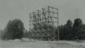
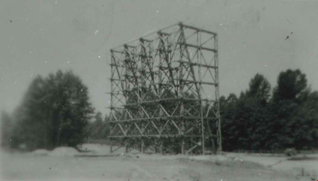
- Scope and Content
- Photograph of the Cascade Drive-In Theatre screen tower at 4050 Grandview Highway.
- Repository
- City of Burnaby Archives
- Date
- 1946 (date of original), copied 1991
- Collection/Fonds
- Burnaby Historical Society fonds
- Subseries
- Burnaby Image Bank subseries
- Physical Description
- 1 photograph : b&w ; 2.6 x 4.5 cm print on contact sheet 20.1 x 26.7 cm
- Description Level
- Item
- Record No.
- 370-466
- Access Restriction
- No restrictions
- Reproduction Restriction
- No known restrictions
- Accession Number
- BHS1999-03
- Scope and Content
- Photograph of the Cascade Drive-In Theatre screen tower at 4050 Grandview Highway.
- Names
- Cascade Drive-In Theatre
- Media Type
- Photograph
- Notes
- Title based on contents of photograph
- 1 b&w copy negative accompanying
- Negative has a pink cast
- Geographic Access
- Grandview Highway
- Street Address
- 4050 Grandview Highway
- Historic Neighbourhood
- Broadview (Historic Neighbourhood)
- Planning Study Area
- West Central Valley Area
Images

Cascade Drive-In Theatre
https://search.heritageburnaby.ca/link/archivedescription37879
- Repository
- City of Burnaby Archives
- Date
- 1947 (date of original), copied 1991
- Collection/Fonds
- Burnaby Historical Society fonds
- Description Level
- Item
- Physical Description
- 1 photograph : b&w ; 3.1 x 4.8 cm print on contact sheet 20.1 x 26.7 cm
- Scope and Content
- Photograph of the Cascade Drive-In Theatre, 4050 Grandview Highway, at dusk. Cars are seen parked in front of the screen and the mountains are visible in the background.
- Repository
- City of Burnaby Archives
- Date
- 1947 (date of original), copied 1991
- Collection/Fonds
- Burnaby Historical Society fonds
- Subseries
- Burnaby Image Bank subseries
- Physical Description
- 1 photograph : b&w ; 3.1 x 4.8 cm print on contact sheet 20.1 x 26.7 cm
- Description Level
- Item
- Record No.
- 370-467
- Access Restriction
- No restrictions
- Reproduction Restriction
- No known restrictions
- Accession Number
- BHS1999-03
- Scope and Content
- Photograph of the Cascade Drive-In Theatre, 4050 Grandview Highway, at dusk. Cars are seen parked in front of the screen and the mountains are visible in the background.
- Names
- Cascade Drive-In Theatre
- Media Type
- Photograph
- Notes
- Title based on contents of photograph
- 1 b&w copy negative accompanying
- Negative has a pink cast
- Geographic Access
- Grandview Highway
- Street Address
- 4050 Grandview Highway
- Historic Neighbourhood
- Broadview (Historic Neighbourhood)
- Planning Study Area
- West Central Valley Area
Images

Cascades Drive-in Theatre
https://search.heritageburnaby.ca/link/archivedescription79337
- Repository
- City of Burnaby Archives
- Date
- September 9, 1976
- Collection/Fonds
- Burnaby Public Library Contemporary Visual Archive Project
- Description Level
- Item
- Physical Description
- 1 photograph : b&w ; 11 x 16 cm mounted on cardboard
- Scope and Content
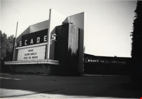
- Photograph shows the Cascades Drive-in Theatre at 3960 Canada Way (previously 4050 Grandview Highway). The theatre was built in 1947.
- Repository
- City of Burnaby Archives
- Date
- September 9, 1976
- Collection/Fonds
- Burnaby Public Library Contemporary Visual Archive Project
- Physical Description
- 1 photograph : b&w ; 11 x 16 cm mounted on cardboard
- Description Level
- Item
- Record No.
- 556-250
- Access Restriction
- No restrictions
- Reproduction Restriction
- Reproduce for fair dealing purposes only
- Accession Number
- 2013-13
- Scope and Content
- Photograph shows the Cascades Drive-in Theatre at 3960 Canada Way (previously 4050 Grandview Highway). The theatre was built in 1947.
- Names
- Cascade Drive-In Theatre
- Media Type
- Photograph
- Photographer
- Norton, Paul
- Notes
- Scope note taken directly from BPL photograph description.
- 1 b&w copy negative : 10 x 12.5 cm accompanying
- Geographic Access
- Canada Way
- Grandview Highway
- Street Address
- 3960 Canada Way
- 4050 Grandview Highway
- Historic Neighbourhood
- Broadview (Historic Neighbourhood)
- Planning Study Area
- West Central Valley Area
Images


Cascades Drive-In Theatre
https://search.heritageburnaby.ca/link/archivedescription37877
- Repository
- City of Burnaby Archives
- Date
- July 1952 (date of original), copied 1991
- Collection/Fonds
- Burnaby Historical Society fonds
- Description Level
- Item
- Physical Description
- 1 photograph : b&w ; 3.3 x 4.1 cm print on contact sheet 20.1 x 26.7 cm
- Scope and Content
- Aerial photograph of the Cascade Drive-In Theatre at 4050 Grandview Highway.
- Repository
- City of Burnaby Archives
- Date
- July 1952 (date of original), copied 1991
- Collection/Fonds
- Burnaby Historical Society fonds
- Subseries
- Burnaby Image Bank subseries
- Physical Description
- 1 photograph : b&w ; 3.3 x 4.1 cm print on contact sheet 20.1 x 26.7 cm
- Description Level
- Item
- Record No.
- 370-465
- Access Restriction
- No restrictions
- Reproduction Restriction
- No restrictions
- Accession Number
- BHS1999-03
- Scope and Content
- Aerial photograph of the Cascade Drive-In Theatre at 4050 Grandview Highway.
- Names
- Cascade Drive-In Theatre
- Media Type
- Photograph
- Photographer
- Cunningham, W.
- Notes
- Title based on contents of photograph
- 1 b&w copy negative accompanying
- Negative has a pink cast
- Geographic Access
- Grandview Highway
- Street Address
- 4050 Grandview Highway
- Historic Neighbourhood
- Broadview (Historic Neighbourhood)
- Planning Study Area
- West Central Valley Area
Images

Interview with Janet White May 10, 2005 - Track 5
https://search.heritageburnaby.ca/link/museumdescription4471
- Repository
- Burnaby Village Museum
- Date
- [195-] (interview content), interviewed May 10, 2005
- Collection/Fonds
- Burnaby Village Museum fonds
- Description Level
- Item
- Physical Description
- 1 sound recording (mp3) (0:03:39 min)
- Scope and Content
- Track 5: This portion of the recording pertains to restrictions on children and youth of the time, and where children played. Janet describes her curfews, and the where she wasn’t supposed to play. She describes sneaking into the Cascades Drive-In with friends. As a teenager, she went to Hazel’s Ca…
- Repository
- Burnaby Village Museum
- Collection/Fonds
- Burnaby Village Museum fonds
- Series
- Museum Oral Histories series
- Subseries
- Growing Up in Burnaby subseries
- Description Level
- Item
- Physical Description
- 1 sound recording (mp3) (0:03:39 min)
- Material Details
- Interviewer: Tom Gooden Interviewee: Janet White Date of interview: May 10, 2005 Total Number of Tracks: 8 Total length of all Tracks: 0:31:34
- Scope and Content
- Track 5: This portion of the recording pertains to restrictions on children and youth of the time, and where children played. Janet describes her curfews, and the where she wasn’t supposed to play. She describes sneaking into the Cascades Drive-In with friends. As a teenager, she went to Hazel’s Café on Sunset where high school students and “drop-outs” mixed. Janet remarks on the lack of racial diversity in the part of Burnaby she lived in at that time.
- History
- Recording of an interview with Janet White recording by Tom Gooden on May 10 2005. This recording was completed for an exhibit, Growing Up in Burnaby, for the Burnaby Village Museum. Major themes discussed are growing up in Burnaby in the 1950s.
- Creator
- Burnaby Village Museum
- Names
- Gooden, Tom
- White, Janet
- Accession Code
- BV017.45.1
- Access Restriction
- No restrictions
- Reproduction Restriction
- May be restricted by third party rights
- Date
- [195-] (interview content), interviewed May 10, 2005
- Media Type
- Sound Recording
Audio Tracks
Interview with Janet White May 10, 2005 - Track 5, [195-] (interview content), interviewed May 10, 2005
Interview with Janet White May 10, 2005 - Track 5, [195-] (interview content), interviewed May 10, 2005
https://search.heritageburnaby.ca/media/hpo/_Data/_BVM_Sound_Recordings/Oral_Histories/2017_0045_0001_005.mp3![Joe Johnson at Lougheed Drive-In Theatre, [1954] (date of original), copied 1991 thumbnail](/media/hpo/_Data/_Archives_Images/_Unrestricted/370/370-483.jpg?width=280)
Joe Johnson at Lougheed Drive-In Theatre
https://search.heritageburnaby.ca/link/archivedescription37895
- Repository
- City of Burnaby Archives
- Date
- [1954] (date of original), copied 1991
- Collection/Fonds
- Burnaby Historical Society fonds
- Description Level
- Item
- Physical Description
- 1 photograph : b&w ; 3.0 x 3.0 cm print on contact sheet 20.4 x 26.9 cm
- Scope and Content
- Photograph of Joe Johnston standing in front of a car at the Lougheed Drive-In Theatre on the 4200 block of Lougheed Highway at Gilmore Avenue.
- Repository
- City of Burnaby Archives
- Date
- [1954] (date of original), copied 1991
- Collection/Fonds
- Burnaby Historical Society fonds
- Subseries
- Burnaby Image Bank subseries
- Physical Description
- 1 photograph : b&w ; 3.0 x 3.0 cm print on contact sheet 20.4 x 26.9 cm
- Description Level
- Item
- Record No.
- 370-483
- Access Restriction
- No restrictions
- Reproduction Restriction
- No restrictions
- Accession Number
- BHS1999-03
- Scope and Content
- Photograph of Joe Johnston standing in front of a car at the Lougheed Drive-In Theatre on the 4200 block of Lougheed Highway at Gilmore Avenue.
- Media Type
- Photograph
- Notes
- Title based on contents of photograph
- 1 b&w copy negative accompanying
- Negative has a pink cast
- Geographic Access
- Lougheed Highway
- Historic Neighbourhood
- Broadview (Historic Neighbourhood)
- Planning Study Area
- West Central Valley Area
Images
![Joe Johnson at Lougheed Drive-In Theatre, [1954] (date of original), copied 1991 thumbnail](/media/hpo/_Data/_Archives_Images/_Unrestricted/370/370-483.jpg)
![Lindsay Johnson at the Lougheed Drive-In Theatre, [1964] (date of original), copied 1991 thumbnail](/media/hpo/_Data/_Archives_Images/_Unrestricted/370/370-477.jpg?width=280)
Lindsay Johnson at the Lougheed Drive-In Theatre
https://search.heritageburnaby.ca/link/archivedescription37889
- Repository
- City of Burnaby Archives
- Date
- [1964] (date of original), copied 1991
- Collection/Fonds
- Burnaby Historical Society fonds
- Description Level
- Item
- Physical Description
- 1 photograph : b&w ; 2.9 x 4.4 cm print on contact sheet 20.4 x 26.9 cm
- Scope and Content
- Photograph of Lindsay Johnson at the Lougheed Drive-In Theatre on the 4200 block of Lougheed Highway at Gilmore Avenue, in the snow.
- Repository
- City of Burnaby Archives
- Date
- [1964] (date of original), copied 1991
- Collection/Fonds
- Burnaby Historical Society fonds
- Subseries
- Burnaby Image Bank subseries
- Physical Description
- 1 photograph : b&w ; 2.9 x 4.4 cm print on contact sheet 20.4 x 26.9 cm
- Description Level
- Item
- Record No.
- 370-477
- Access Restriction
- No restrictions
- Reproduction Restriction
- No restrictions
- Accession Number
- BHS1999-03
- Scope and Content
- Photograph of Lindsay Johnson at the Lougheed Drive-In Theatre on the 4200 block of Lougheed Highway at Gilmore Avenue, in the snow.
- Names
- Johnson, Lindsay
- Media Type
- Photograph
- Notes
- Title based on contents of photograph
- 1 b&w copy negative accompanying
- Negative has a pink cast
- Copied from col. photograph
- Geographic Access
- Lougheed Highway
- Historic Neighbourhood
- Broadview (Historic Neighbourhood)
- Planning Study Area
- West Central Valley Area
Images
![Lindsay Johnson at the Lougheed Drive-In Theatre, [1964] (date of original), copied 1991 thumbnail](/media/hpo/_Data/_Archives_Images/_Unrestricted/370/370-477.jpg)
![Lougheed Drive-In Theatre, [1955] (date of original), copied 1991 thumbnail](/media/hpo/_Data/_Archives_Images/_Unrestricted/370/370-475.jpg?width=280)
Lougheed Drive-In Theatre
https://search.heritageburnaby.ca/link/archivedescription37887
- Repository
- City of Burnaby Archives
- Date
- [1955] (date of original), copied 1991
- Collection/Fonds
- Burnaby Historical Society fonds
- Description Level
- Item
- Physical Description
- 1 photograph : b&w ; 2.9 x 4.2 cm print on contact sheet 20.4 x 26.9 cm
- Scope and Content
- Photograph of Lougheed Drive-In Theatre on the 4200 block of Lougheed Highway at Gilmore Avenue, while empty.
- Repository
- City of Burnaby Archives
- Date
- [1955] (date of original), copied 1991
- Collection/Fonds
- Burnaby Historical Society fonds
- Subseries
- Burnaby Image Bank subseries
- Physical Description
- 1 photograph : b&w ; 2.9 x 4.2 cm print on contact sheet 20.4 x 26.9 cm
- Description Level
- Item
- Record No.
- 370-475
- Access Restriction
- No restrictions
- Reproduction Restriction
- No restrictions
- Accession Number
- BHS1999-03
- Scope and Content
- Photograph of Lougheed Drive-In Theatre on the 4200 block of Lougheed Highway at Gilmore Avenue, while empty.
- Media Type
- Photograph
- Notes
- Title based on contents of photograph
- 1 b&w copy negative accompanying
- Negative has a pink cast
- Geographic Access
- Lougheed Highway
- Historic Neighbourhood
- Broadview (Historic Neighbourhood)
- Planning Study Area
- West Central Valley Area
Images
![Lougheed Drive-In Theatre, [1955] (date of original), copied 1991 thumbnail](/media/hpo/_Data/_Archives_Images/_Unrestricted/370/370-475.jpg)
![Lougheed Drive-In Theatre storm damage, [1962] (date of original), copied 1991 thumbnail](/media/hpo/_Data/_Archives_Images/_Unrestricted/370/370-469.jpg?width=280)
Lougheed Drive-In Theatre storm damage
https://search.heritageburnaby.ca/link/archivedescription37881
- Repository
- City of Burnaby Archives
- Date
- [1962] (date of original), copied 1991
- Collection/Fonds
- Burnaby Historical Society fonds
- Description Level
- Item
- Physical Description
- 1 photograph : b&w ; 3.0 x 3.0 cm print on contact sheet 20.1 x 26.7 cm
- Scope and Content
- Photograph of the damage caused by Typhoon "Freda" on October 12, 1962 to the tower and screen of the Lougheed Drive-In Theatre on the 4200 block of Lougheed Highway at Gilmore Avenue.
- Repository
- City of Burnaby Archives
- Date
- [1962] (date of original), copied 1991
- Collection/Fonds
- Burnaby Historical Society fonds
- Subseries
- Burnaby Image Bank subseries
- Physical Description
- 1 photograph : b&w ; 3.0 x 3.0 cm print on contact sheet 20.1 x 26.7 cm
- Description Level
- Item
- Record No.
- 370-469
- Access Restriction
- No restrictions
- Reproduction Restriction
- No restrictions
- Accession Number
- BHS1999-03
- Scope and Content
- Photograph of the damage caused by Typhoon "Freda" on October 12, 1962 to the tower and screen of the Lougheed Drive-In Theatre on the 4200 block of Lougheed Highway at Gilmore Avenue.
- Media Type
- Photograph
- Notes
- Title based on contents of photograph
- 1 b&w copy negative accompanying
- Copy negative has a pink cast
- 2 b&w copy prints accompanying
- Geographic Access
- Lougheed Highway
- Historic Neighbourhood
- Broadview (Historic Neighbourhood)
- Planning Study Area
- West Central Valley Area
Images
![Lougheed Drive-In Theatre storm damage, [1962] (date of original), copied 1991 thumbnail](/media/hpo/_Data/_Archives_Images/_Unrestricted/370/370-469.jpg)