Narrow Results By
Decade
- 2020s 23
- 2010s 66
- 2000s 78
- 1990s 124
- 1980s 137
- 1970s 122
- 1960s 94
- 1950s 91
- 1940s 169
- 1930s 91
- 1920s 154
- 1910s 129
- 1900s 60
- 1890s 30
- 1880s 6
- 1870s 7
- 1860s 12
- 1850s 5
- 1840s 3
- 1830s 2
- 1820s 2
- 1810s 2
- 1800s 2
- 1790s 1
- 1780s 1
- 1770s 1
- 1760s 1
- 1750s 1
- 1740s 1
- 1730s 1
- 1720s 1
- 1710s 1
- 1700s 1
- 1690s 1
- 1680s 1
- 1670s 1
- 1660s 1
- 1650s 1
- 1640s 1
- 1630s 1
- 1620s 1
- 1610s 1
- 1600s 1

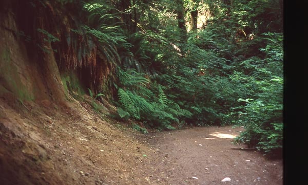
Cut of land on Burnaby Mountain
https://search.heritageburnaby.ca/link/archivedescription97810
- Repository
- City of Burnaby Archives
- Date
- 1996
- Collection/Fonds
- Burnaby Mountain Preservation Society fonds
- Description Level
- Item
- Physical Description
- 1 photograph : col. slide ; 35 mm
- Scope and Content
- Photograph of a cut of land.
- Repository
- City of Burnaby Archives
- Date
- 1996
- Collection/Fonds
- Burnaby Mountain Preservation Society fonds
- Physical Description
- 1 photograph : col. slide ; 35 mm
- Description Level
- Item
- Record No.
- 629-011
- Access Restriction
- No restrictions
- Reproduction Restriction
- Reproduce for fair dealing purposes only
- Accession Number
- 2006-13
- Scope and Content
- Photograph of a cut of land.
- Subjects
- Geographic Features - Trails
- Media Type
- Photograph
- Notes
- Stamp on slide reads: "July 08, 1996."
- Geographic Access
- Burnaby Mountain Conservation Area
- Planning Study Area
- Burnaby Mountain Area
Images
Deed of Land between George A. Stevens and George Leonard re District Lot 352 South Vancouver
https://search.heritageburnaby.ca/link/museumdescription18783
- Repository
- Burnaby Village Museum
- Date
- 28 Mar. 1908
- Collection/Fonds
- Love family fonds
- Description Level
- Item
- Physical Description
- 1 p. of textual records
- Scope and Content
- Item consists of Deed of Land between George A. Stevens and George Leonard for South Vancouver Lots eleven (11) and twelve (12) of the Subdivision of Lots nine (9), ten (10), eleven (11), twelve (12) and thirteen (13) of Block sixteen (16) in District Lot 352.
- Repository
- Burnaby Village Museum
- Collection/Fonds
- Love family fonds
- Description Level
- Item
- Physical Description
- 1 p. of textual records
- Scope and Content
- Item consists of Deed of Land between George A. Stevens and George Leonard for South Vancouver Lots eleven (11) and twelve (12) of the Subdivision of Lots nine (9), ten (10), eleven (11), twelve (12) and thirteen (13) of Block sixteen (16) in District Lot 352.
- Accession Code
- BV992.26.3
- Access Restriction
- No restrictions
- Reproduction Restriction
- No known restrictions
- Date
- 28 Mar. 1908
- Media Type
- Textual Record
- Notes
- Title based on contents of item
- buff paper, legal-sized, with black print; pink borders; folds out.
- Front of folded cover reads: "Dated March 28th 1908 / George A. Stevens / TO / George Leonard / DEED OF LAND / SITUATE I / South Vancouver / AND BEING / Lots Eleven (11) & Twelve (12) SubDiv (9)(10)(11)(12)&(13) Bk. (16) & Lot (352)" "115.5 x 33 / EVANS & HASTINGS PRINTERS"
- Inside reads: "This Indenture.../ between George A. Stevens of the City of Vancouver.../ And / George Leonard.../ ...sum of eight hundred and fifty ($850) .../ ... Lots Eleven (11) & Twelve (12) of the Subdivision of Lots nine (9) Ten (10) Eleven (11) Twelve (12) and Thirteen (13) / of Block Sixteen (16) in DistLot-Three Hundred & / fifty two (352) Group one (1) New Westminster District..."
- signed by George Stevens twice, small red seals; witnessed twice by William Carter; "FOR MAKER" signed by William Carter, April 4, 1908; stamp seal "WILLIAM CARTER" "BRITISH COLUMBIA" "NOTARY PUBLIC"
Deed of Land between George R. Love and Jesse Love re Lot 56 of Lot 7, subdivision of Block 12
https://search.heritageburnaby.ca/link/museumdescription18785
- Repository
- Burnaby Village Museum
- Date
- 16 Sep. 1911
- Collection/Fonds
- Love family fonds
- Description Level
- Item
- Physical Description
- 1 p. of textual records
- Scope and Content
- Item consists of Deed of Land dated September 16, 1911 between George R. Love and Jesse Love for Lot fifty-six (56) of Lot seven (7), Subdivision of Block twelve (12).
- Repository
- Burnaby Village Museum
- Collection/Fonds
- Love family fonds
- Description Level
- Item
- Physical Description
- 1 p. of textual records
- Material Details
- watermark "BERKSHIRE BOND"
- Scope and Content
- Item consists of Deed of Land dated September 16, 1911 between George R. Love and Jesse Love for Lot fifty-six (56) of Lot seven (7), Subdivision of Block twelve (12).
- Accession Code
- BV992.26.5
- Access Restriction
- No restrictions
- Reproduction Restriction
- No known restrictions
- Date
- 16 Sep. 1911
- Media Type
- Textual Record
- Notes
- Title based on contents of item
- document dated Sept. 16th 1911; "George R. Love" "East Burnaby, B.C." "TO" "Jessie Love" "East Burnaby, B.C."; "Deed of Land" "SITUATE IN" "City of New Westminster, B.C."; stamped in red with land registry office stamp, "NOT EXAMINED" "SEP 25 1911" "...DUPLICATE..." "32261"; printed below, "F.J. HART & CO., LTD." "REAL ESTATE, NOTARIES PUBLIC" "CONVEYANCERS" NEW WESTMINSTER, VANCOUVER AND CHILLIWACK, B.C."; at bottom, "JACKSON PRINTING COMPANY, NEW WESTMINSTER"; buff paper, folds out to legal size; pink, blue and white borders; black print, blue typewriting (carbon); "This Indenture", for $1000, for parcel of land Lot 56 of Lot 7, subdivision of Bl.12, suburban, New Westminster, B.C.; subject to indenture of mortgage between George R. Love and The British Columbia Permanent Loan Company, and to agreement for sale with Mr. and Mrs. Morrison; signed by George R. Love, small red seal; witnessed by H.A. Eastman; "FOR MAKER" signed by H.A. Eastman, Sept. 27, 1911; stamp seal "HENRY ALFRED EASTMAN" "BRITISH COLUMBIA" "NOTARY PUBLIC".
Deed of Land between Henry A. Eastman and George R. Love re Lots 55 and 56 of Lot 7 and 12
https://search.heritageburnaby.ca/link/museumdescription18786
- Repository
- Burnaby Village Museum
- Date
- 7 Apr. 1911
- Collection/Fonds
- Love family fonds
- Description Level
- Item
- Physical Description
- 1 p. of textual records
- Scope and Content
- Item consists of Deed of Land dated April 7, 1911 between Henry Alfred Eastman and George R. Love of East Burnaby for Lots fifty-five (55) and fifty-six (56) of Lot seven (7), Block twelve (12) Suburban.
- Repository
- Burnaby Village Museum
- Collection/Fonds
- Love family fonds
- Description Level
- Item
- Physical Description
- 1 p. of textual records
- Material Details
- watermark "BERKSHIRE BOND"
- Scope and Content
- Item consists of Deed of Land dated April 7, 1911 between Henry Alfred Eastman and George R. Love of East Burnaby for Lots fifty-five (55) and fifty-six (56) of Lot seven (7), Block twelve (12) Suburban.
- Accession Code
- BV992.26.6
- Access Restriction
- No restrictions
- Reproduction Restriction
- No known restrictions
- Date
- 7 Apr. 1911
- Media Type
- Textual Record
- Notes
- Title based on contents of item
- document, buff paper, legal-sized; dated April 7th, 1911; "HENRY A. EASTMAN" of New Westminster, B.C. to "GEORGE R. LOVE" of East Burnaby, B.C.; "This Indenture", for the payment of $1400, is for parcels or tracts of land in New Westminster, Lots 55 and 56 of Lot 7, Block 12 Suburban; typing is purple, carbon?; signed by H.A. Eastman, witnessed by R.K. Chapman; red seal and impressed seal "ROBERT KEAM CHAPMAN" "BRITISH COLUMBIA" "NOTARY PUBLIC"; when folded, outside panel has "Deed of Land SITUATE IN City of New Westminster, B.C."; stamped in red "LAND REGISTRY OFFICE" "NEW WESTMINSTER, B.C." "NOT EXAMINED" "APR 8- 1911" "THIS PURPORTS TO BE A DUPLICATE ONLY, ORIGINAL DEPOSITED WITH APPLICATION NO.", black stamp; "28041"; at bottom, "F.J. HART & CO., LTD." "REAL ESTATE, NOTARIES PUBLIC", "CONVEYANCERS", "NEW WESTMINSTER, VANCOUVER AND CHILLIWACK, B.C."; Jackson Printing Company, New Westminster;
Deed of Land between L. Claude Hill and Frank Smith and William Reid re Subdivision 8 of Lot 5 Block 13
https://search.heritageburnaby.ca/link/museumdescription18784
- Repository
- Burnaby Village Museum
- Date
- 13 Mar. 1911
- Collection/Fonds
- Love family fonds
- Description Level
- Item
- Physical Description
- 1 p. of textual records
- Scope and Content
- Item consists of Item consists of a Deed of Land between L. Claude Hill and Frank P. Smith and William T. Reidl for Subdivision eight (8) of South Half of Lot five (5), Suburban Block Thirteen (XIII).
- Repository
- Burnaby Village Museum
- Collection/Fonds
- Love family fonds
- Description Level
- Item
- Physical Description
- 1 p. of textual records
- Scope and Content
- Item consists of Item consists of a Deed of Land between L. Claude Hill and Frank P. Smith and William T. Reidl for Subdivision eight (8) of South Half of Lot five (5), Suburban Block Thirteen (XIII).
- Accession Code
- BV992.26.4
- Access Restriction
- No restrictions
- Reproduction Restriction
- No known restrictions
- Date
- 13 Mar. 1911
- Media Type
- Textual Record
- Notes
- Title based on contents of item
- document, dated March 13th 1911; "L. CLAUDE HILL" "TO" "FRANK P. SMITH AND WILLIAM T. REID."; "Deed of Land" "SITUATE IN" "Subd. 8. Lot Five Sub. Blk. XIII."; "27361"; overstamped in red with "LAND REGISTRY OFFICE" stamp, "NOT EXAMINED" "...DUPLICATE ONLY..."; printed below inside decorative border, "REAL ESTATE" "PHONE 169" "J.J. JOHNSTON" "COLUMBIA ST NEW WESTMINSTER, B.C." "INSURANCE"; printed below border is "JACKSON PRINTING COMPANY, NEW WESTMINSTER"
- buff paper, folds out to legal-sized; black print, pink, white and blue borders; "This Indenture", all parties from New Westminster; for $350, for parcel named; signed by L. Claude Hill, small red seal; witnessed by Clayton A. Bourne; "FOR WITNESS" section signed March 16, 1911, by J.J. Johnston, Commissioner for taking Affidavits in B.C.;
Deed of Land between Smith, Reid and Lindahl re Subdivision 8 of Lot 5 Block 13
https://search.heritageburnaby.ca/link/museumdescription18782
- Repository
- Burnaby Village Museum
- Date
- 13 Mar. 1911
- Collection/Fonds
- Love family fonds
- Description Level
- Item
- Physical Description
- 1 p. of textual records
- Scope and Content
- Item consists of a Deed of Land between Frank P. Smith and William T. Reid and Henrick Lindahl for Subdivision eight (8) of South Half of Lot five (5), Suburban Block Thirteen (XIII).
- Repository
- Burnaby Village Museum
- Collection/Fonds
- Love family fonds
- Description Level
- Item
- Physical Description
- 1 p. of textual records
- Scope and Content
- Item consists of a Deed of Land between Frank P. Smith and William T. Reid and Henrick Lindahl for Subdivision eight (8) of South Half of Lot five (5), Suburban Block Thirteen (XIII).
- Accession Code
- BV992.26.2
- Access Restriction
- No restrictions
- Reproduction Restriction
- No known restrictions
- Date
- 13 Mar. 1911
- Media Type
- Textual Record
- Notes
- Title based on contents of item
- "FRANK P. SMITH AND WILLIAM T. REID" "TO" "HENRIK LINDAHL", "Deed of Land" "SITUATE IN" "Subd. 8 Lot Five. Sub. Blk. XIII"; below, printed in decorative border, "REAL ESTATE" "PHONE 169" "J.J. JOHNSTON" "COLUMBIA ST. NEW WESTMINSTER, B.C." "INSURANCE"; overstamped in red with land registry office stamp, "NOT EXAMINED" "MAR 17 1911" "THIS PURPORTS TO BE A DUPLICATE... 27362"; below border, "JACKSON PRINTING COMPANY, NEW WESTMINSTER"; buff paper, legal-sized, black print, pink, white and blue borders; opens out to "This Indenture", between Smith and Reid of New Westminster and Lindahl of New Westminster; for $350 for said parcel; typed, purple carbon paper; signed by Smith and Reid, small red seals; witnessed by Clayton A. Bourne; "FOR WITNESS" signed by J.J.Johnston, Commissioner for taking Affidavits in B.C.
Deed of land - estate of George Leonard to Martha Love
https://search.heritageburnaby.ca/link/museumdescription10085
- Repository
- Burnaby Village Museum
- Date
- 1909
- Collection/Fonds
- Love family fonds
- Description Level
- Item
- Physical Description
- 1 folder of textual records
- Scope and Content
- Item consists of a Deed of Land between the executors, "George Alfred Stevens and Edmund Evans" of the Will of George Leonard to Martha Love, dated August 5, 1909 re: Lots 11 and 12 in re-subdivision of Lots 9 to 13, Block 16, District Lot 352, Group One, Vancouver District.
- Repository
- Burnaby Village Museum
- Collection/Fonds
- Love family fonds
- Description Level
- Item
- Physical Description
- 1 folder of textual records
- Material Details
- "DATED August 1909 / GEORGE ALFRED STEVENS & / EDMUND EVANS / to / MARTHA LOVE. / DEED OF LAND / McLELLAN & SAVAGE.", printed on the outside fold of the page.
- Scope and Content
- Item consists of a Deed of Land between the executors, "George Alfred Stevens and Edmund Evans" of the Will of George Leonard to Martha Love, dated August 5, 1909 re: Lots 11 and 12 in re-subdivision of Lots 9 to 13, Block 16, District Lot 352, Group One, Vancouver District.
- History
- See extensive history of Love Family and Love farmhouse located at Burnaby Village Museum.
- Accession Code
- BV012.31.17
- Access Restriction
- No restrictions
- Reproduction Restriction
- No known restrictions
- Date
- 1909
- Media Type
- Textual Record
- Notes
- Title based on content of file
Deed of land - Lloyd Sipprell and William and Sarah Parker
https://search.heritageburnaby.ca/link/museumdescription10081
- Repository
- Burnaby Village Museum
- Date
- Aug. 4, 1932
- Collection/Fonds
- Love family fonds
- Description Level
- Item
- Physical Description
- 1 p. of textual records
- Scope and Content
- Item consists of Deed of Land title from Lloyd Langdon Sipprell to William Michael Parker and Sarah Maria Parker re: South Easterly 80 feet by 168 feet of Block 1 of the East part of Lot 25, Group 1 Map 813.
- Repository
- Burnaby Village Museum
- Collection/Fonds
- Love family fonds
- Description Level
- Item
- Physical Description
- 1 p. of textual records
- Material Details
- "This Indenture / made the Fourth day of August in the / year of our Lord one thousand and Thirty-two / . . . . / LLOYD LANGDON SIPPRELL . . . ./ AND / WILLIAM MICHAEL PARKER . . . / And / SARAH MARIA PARKER . . "printed and typed at top of document "J. J. JOHNSTON / REAL ESTATE & INSURANCE / NEW WESTMINSER, B.C." business stamp on outside fold of document.
- Scope and Content
- Item consists of Deed of Land title from Lloyd Langdon Sipprell to William Michael Parker and Sarah Maria Parker re: South Easterly 80 feet by 168 feet of Block 1 of the East part of Lot 25, Group 1 Map 813.
- History
- See extensive history of Love Family and Love farmhouse located at Burnaby Village Museum.
- Accession Code
- BV012.31.13
- Access Restriction
- No restrictions
- Reproduction Restriction
- No known restrictions
- Date
- Aug. 4, 1932
- Media Type
- Textual Record
- Notes
- Title based on content of file
Deed of Land Sale - fragment
https://search.heritageburnaby.ca/link/museumdescription10089
- Repository
- Burnaby Village Museum
- Date
- [1893]
- Collection/Fonds
- Love family fonds
- Description Level
- Item
- Physical Description
- 1 p. of textual records
- Scope and Content
- Item consists of the bottom portion of a Deed of Land Sale. It contains a hand written, legal description of property which reads: "Cumberland Road in Lot 25, G. 1, N.W. Dist the / same being distant 14.18 Chs. S. 63.30 (degrees) E, from / the Northeast corner of said Lot 25; thense S. 63.30 E....a…
- Repository
- Burnaby Village Museum
- Collection/Fonds
- Love family fonds
- Description Level
- Item
- Physical Description
- 1 p. of textual records
- Scope and Content
- Item consists of the bottom portion of a Deed of Land Sale. It contains a hand written, legal description of property which reads: "Cumberland Road in Lot 25, G. 1, N.W. Dist the / same being distant 14.18 Chs. S. 63.30 (degrees) E, from / the Northeast corner of said Lot 25; thense S. 63.30 E....and containing by estimaton ten (10) acres...".
- History
- See extensive history of Love Family and Love farmhouse located at Burnaby Village Museum.
- Accession Code
- BV012.31.21
- Access Restriction
- No restrictions
- Reproduction Restriction
- No known restrictions
- Date
- [1893]
- Media Type
- Textual Record
- Notes
- Title based on content of file
Deed of land - Wallace Whiting, George Love, Henry Love and William and Sarah Parker
https://search.heritageburnaby.ca/link/museumdescription10082
- Repository
- Burnaby Village Museum
- Date
- 1942 and 1962
- Collection/Fonds
- Love family fonds
- Description Level
- Item
- Physical Description
- 1 p. of textual records
- Scope and Content
- Item consists of Deed of Land title between Wallace Whiting, George Love and Henry Love and William Michael and Sarah Maria Parker re: Parcel "F: Block 1, Lot 25, Group 1 (on Cumberland Road in Burnaby). A note is pinned to the top of the document with a typed note "LAND REGISTRY / NEW WEST'R, B.C…
- Repository
- Burnaby Village Museum
- Collection/Fonds
- Love family fonds
- Description Level
- Item
- Physical Description
- 1 p. of textual records
- Material Details
- "This Indenture / made the TWENTYFOURTH day of August in the year of our / Lord one thousand and FORTY Two / . . . . / WALLACE WHITING . . . / GEORGE RICHARD LOVE . . . / HENRY LOVE . . . . . . . ./ AND / WILLIAM MICHAEL PARKER . . . / And / SARAH MARIA PARKER . . / Witnesseth, that in consideration of the sum of / ONE DOLLAR ($1.00) "printed and typed at top of document "Reg # 152828 / Dated August 24th 1942 / W. Whiting / G.R. Love / H. Love / TO W.M. Parker / S.M. Parker / Deed of Land / Parcel " F " / Blk 1 / Lot 25 / Grp 1" printed and type written on the outside fold of document.
- Scope and Content
- Item consists of Deed of Land title between Wallace Whiting, George Love and Henry Love and William Michael and Sarah Maria Parker re: Parcel "F: Block 1, Lot 25, Group 1 (on Cumberland Road in Burnaby). A note is pinned to the top of the document with a typed note "LAND REGISTRY / NEW WEST'R, B.C. / 1962 JUL 19 PM 2:55".
- History
- See extensive history of Love Family and Love farmhouse located at Burnaby Village Museum.
- Accession Code
- BV012.31.14
- Access Restriction
- Restricted access
- Reproduction Restriction
- May be restricted by third party rights
- Date
- 1942 and 1962
- Media Type
- Textual Record
- Notes
- Title based on content of file

Ernie Carpenter clearing land
https://search.heritageburnaby.ca/link/archivedescription35789
- Repository
- City of Burnaby Archives
- Date
- 1923 (date of original), copied 1986
- Collection/Fonds
- Burnaby Historical Society fonds
- Description Level
- Item
- Physical Description
- 1 photograph : b&w ; 12.7 x 17.8 cm print
- Scope and Content
- Photograph of Ernie Carpenter clearing a lot at 3336 Beresford Street (later renumbered 5268 Beresford Street) near Royal Oak Avenue. Mr. Carpenter built a house here, and then cultivated an English garden and prize-winning onions and flowers.
- Repository
- City of Burnaby Archives
- Date
- 1923 (date of original), copied 1986
- Collection/Fonds
- Burnaby Historical Society fonds
- Subseries
- Pioneer Tales subseries
- Physical Description
- 1 photograph : b&w ; 12.7 x 17.8 cm print
- Description Level
- Item
- Record No.
- 204-647
- Access Restriction
- No restrictions
- Reproduction Restriction
- No known restrictions
- Accession Number
- BHS1988-03
- Scope and Content
- Photograph of Ernie Carpenter clearing a lot at 3336 Beresford Street (later renumbered 5268 Beresford Street) near Royal Oak Avenue. Mr. Carpenter built a house here, and then cultivated an English garden and prize-winning onions and flowers.
- Subjects
- Land Clearing
- Plants - Trees
- Names
- Carpenter, Ernie
- Media Type
- Photograph
- Notes
- Title based on contents of photograph
- Geographic Access
- Beresford Street
- Street Address
- 5268 Beresford Street
- Historic Neighbourhood
- Central Park (Historic Neighbourhood)
- Planning Study Area
- Windsor Area
Images

![George Searby Buxton Clearing Land, [1911] thumbnail](/media/hpo/_Data/_Archives_Images/_Unrestricted/513/513-001.JPG?width=280)
George Searby Buxton Clearing Land
https://search.heritageburnaby.ca/link/archivedescription64598
- Repository
- City of Burnaby Archives
- Date
- [1911]
- Collection/Fonds
- Buxton Family collection
- Description Level
- Item
- Physical Description
- 1 photograph (jpeg) : b&w
- Scope and Content
- Photograph shows Burnaby pioneer George Searby Buxton clearing land on which he built his family home in Burnaby. George Buxton was born in England and was a carpenter by trade. He and his wife Mary Isabel (nee Nattriss) moved to Canada between 1911 and 1913 and had five children: Clara Violet (1…
- Repository
- City of Burnaby Archives
- Date
- [1911]
- Collection/Fonds
- Buxton Family collection
- Physical Description
- 1 photograph (jpeg) : b&w
- Description Level
- Item
- Record No.
- 513-001
- Access Restriction
- No restrictions
- Reproduction Restriction
- No known restrictions
- Accession Number
- 2010-05
- Scope and Content
- Photograph shows Burnaby pioneer George Searby Buxton clearing land on which he built his family home in Burnaby. George Buxton was born in England and was a carpenter by trade. He and his wife Mary Isabel (nee Nattriss) moved to Canada between 1911 and 1913 and had five children: Clara Violet (1910-1913), Mary (1900-?), Alice Clarissa (Clissie) (1902-?), Bernard (1897-1972) and Leopold (1893-1951).. The Buxton house remains a heritage landmark in Burnaby to this day.
- Subjects
- Land Clearing
- Names
- Buxton, George Searby
- Media Type
- Photograph
- Geographic Access
- Buxton Street
- Street Address
- 4807 Buxton Street
- Historic Neighbourhood
- Central Park (Historic Neighbourhood)
- Planning Study Area
- Marlborough Area
Images
![George Searby Buxton Clearing Land, [1911] thumbnail](/media/hpo/_Data/_Archives_Images/_Unrestricted/513/513-001.JPG)

Gray family clearing land
https://search.heritageburnaby.ca/link/archivedescription35520
- Repository
- City of Burnaby Archives
- Date
- 1911 (date of original), copied 1986
- Collection/Fonds
- Burnaby Historical Society fonds
- Description Level
- Item
- Physical Description
- 1 photograph : b&w ; 12.7 x 17.8 cm print
- Scope and Content
- Photograph of the Gray family clearing a lot for the family home at 4375 Winnifred Street. Clamor Gray (father of William Gray) and Ernie North (uncle, right), both carpenters, built this house and others for relatives nearby.
- Repository
- City of Burnaby Archives
- Date
- 1911 (date of original), copied 1986
- Collection/Fonds
- Burnaby Historical Society fonds
- Subseries
- Pioneer Tales subseries
- Physical Description
- 1 photograph : b&w ; 12.7 x 17.8 cm print
- Description Level
- Item
- Record No.
- 204-378
- Access Restriction
- No restrictions
- Reproduction Restriction
- No known restrictions
- Accession Number
- BHS1988-03
- Scope and Content
- Photograph of the Gray family clearing a lot for the family home at 4375 Winnifred Street. Clamor Gray (father of William Gray) and Ernie North (uncle, right), both carpenters, built this house and others for relatives nearby.
- Subjects
- Land Clearing
- Plants - Trees
- Names
- Gray, Clamor
- Gray, Ernie
- Media Type
- Photograph
- Notes
- Title based on contents of photograph
- Geographic Access
- Winnifred Street
- Street Address
- 4375 Winnifred Street
- Historic Neighbourhood
- Alta-Vista (Historic Neighbourhood)
- Planning Study Area
- Sussex-Nelson Area
Images

Industrial Land Prospects
https://search.heritageburnaby.ca/link/archivedescription58089
- Repository
- City of Burnaby Archives
- Date
- 1961
- Collection/Fonds
- Burnaby Historical Society fonds
- Description Level
- Item
- Physical Description
- 1 report
- Scope and Content
- Item is a report produced by the Lower Mainland Regional Planning Board of British Columbia entitled "Industrial Land Prospects in the Lower Mainland Region of B.C."
- Repository
- City of Burnaby Archives
- Date
- 1961
- Collection/Fonds
- Burnaby Historical Society fonds
- Subseries
- Eagles family subseries
- Physical Description
- 1 report
- Description Level
- Item
- Record No.
- MSS055-040
- Accession Number
- BHS1991-18
- Scope and Content
- Item is a report produced by the Lower Mainland Regional Planning Board of British Columbia entitled "Industrial Land Prospects in the Lower Mainland Region of B.C."
- Media Type
- Textual Record
- Notes
- Continuation of title: "...in the Lower Mainland Region of B.C."

Interior of land surveyor's office at Burnaby Village Museum
https://search.heritageburnaby.ca/link/museumdescription13768
- Repository
- Burnaby Village Museum
- Date
- Sept. 1987
- Collection/Fonds
- Century Park Museum Association fonds
- Description Level
- Item
- Physical Description
- 1 photograph : col. ; 9 x 12.5 cm
- Scope and Content
- Photograph of the interior of the land surveyor's office at Burnaby Village Museum. Office is furnished with a roll top desk, maps and plans and various surveying tools.
- Repository
- Burnaby Village Museum
- Collection/Fonds
- Century Park Museum Association fonds
- Description Level
- Item
- Physical Description
- 1 photograph : col. ; 9 x 12.5 cm
- Scope and Content
- Photograph of the interior of the land surveyor's office at Burnaby Village Museum. Office is furnished with a roll top desk, maps and plans and various surveying tools.
- Subjects
- Occupations - Land Surveyors
- Names
- Burnaby Village Museum
- Geographic Access
- Deer Lake Avenue
- Accession Code
- BV020.5.958
- Access Restriction
- No restrictions
- Reproduction Restriction
- No known restrictions
- Date
- Sept. 1987
- Media Type
- Photograph
- Scan Resolution
- 600
- Scan Date
- 22-Sep-2020
- Scale
- 100
- Notes
- Title based on contents of photograph
Images


Land being cleared for Saint Theresa's Roman Catholic Church
https://search.heritageburnaby.ca/link/museumdescription902
- Repository
- Burnaby Village Museum
- Date
- 1929
- Collection/Fonds
- Burnaby Village Museum Photograph collection
- Description Level
- Item
- Physical Description
- 1 photograph : b&w ; 6.7 x 11.4 cm
- Scope and Content
- Photograph of three unidentified men standing on Douglas Road (later renamed in part Canada Way) with Laurel Street in the background on the left and the site of Saint Theresa's Roman Catholic Church as a lot with blackened stumps. The church was located at the southeast corner of Canada Way and L…
- Repository
- Burnaby Village Museum
- Collection/Fonds
- Burnaby Village Museum Photograph collection
- Description Level
- Item
- Physical Description
- 1 photograph : b&w ; 6.7 x 11.4 cm
- Scope and Content
- Photograph of three unidentified men standing on Douglas Road (later renamed in part Canada Way) with Laurel Street in the background on the left and the site of Saint Theresa's Roman Catholic Church as a lot with blackened stumps. The church was located at the southeast corner of Canada Way and Laurel Street. According to an accompanying note located with the photograph, the first church building burned to the ground the night before it was to be blessed. Insurance for the church had been arranged for by Colonel Dorrell only hours before it was burned and even though signatures had not been affixed to the policy, the insurance company honoured the claim. The second building was smaller and had no basement. Father Trainer was the first priest. This church was torn down in 1974 and a new church building was erected across the road on Canada Way.
- Subjects
- Land Clearing
- Geographic Access
- Douglas Road
- Canada Way
- Laurel Street
- Accession Code
- HV975.105.1
- Access Restriction
- No restrictions
- Reproduction Restriction
- No known restrictions
- Date
- 1929
- Media Type
- Photograph
- Historic Neighbourhood
- Burnaby Lake (Historic Neighbourhood)
- Planning Study Area
- Douglas-Gilpin Area
- Scan Resolution
- 600
- Scan Date
- 2023-06-06
- Notes
- Title based on contents of photograph
- Information on the scope and content of the photograph is taken from an acquisition record from the time of the accession
Images

![Land belonging to Scotty Walker and the Lady of Mercy Brothers, [1948] (date of original); 2013 (date of duplication) thumbnail](/media/hpo/_Data/_Archives_Images/_Unrestricted/550/557-032.jpg?width=280)
Land belonging to Scotty Walker and the Lady of Mercy Brothers
https://search.heritageburnaby.ca/link/archivedescription78782
- Repository
- City of Burnaby Archives
- Date
- [1948] (date of original); 2013 (date of duplication)
- Collection/Fonds
- Walker family fonds
- Description Level
- Item
- Physical Description
- 1 photograph (jpeg) : b&w ; 200 dpi
- Scope and Content
- Photograph of land belonging to Scotty Walker and the Lady of Mercy Brothers.
- Repository
- City of Burnaby Archives
- Date
- [1948] (date of original); 2013 (date of duplication)
- Collection/Fonds
- Walker family fonds
- Physical Description
- 1 photograph (jpeg) : b&w ; 200 dpi
- Description Level
- Item
- Record No.
- 557-032
- Access Restriction
- No restrictions
- Reproduction Restriction
- No known restrictions
- Accession Number
- 2013-15
- Scope and Content
- Photograph of land belonging to Scotty Walker and the Lady of Mercy Brothers.
- Media Type
- Photograph
- Notes
- Title based on contents of photograph
- Historic Neighbourhood
- Edmonds (Historic Neighbourhood)
- Planning Study Area
- Edmonds Area
Images
![Land belonging to Scotty Walker and the Lady of Mercy Brothers, [1948] (date of original); 2013 (date of duplication) thumbnail](/media/hpo/_Data/_Archives_Images/_Unrestricted/550/557-032.jpg)
![Land Clearing, [1913] (date of original), copied 1986 thumbnail](/media/hpo/_Data/_Archives_Images/_Unrestricted/204/204-226.jpg?width=280)
Land Clearing
https://search.heritageburnaby.ca/link/archivedescription35369
- Repository
- City of Burnaby Archives
- Date
- [1913] (date of original), copied 1986
- Collection/Fonds
- Burnaby Historical Society fonds
- Description Level
- Item
- Physical Description
- 1 photograph : b&w ; 12.7 x 17.8 cm print
- Scope and Content
- Photograph of land clearing by a crew contracted by the municipality to clear the area between Colborne Avenue, Brantford Avenue and Imperial Street in South Burnaby. William Walker was a member of this crew. The land was cleared by blasting.
- Repository
- City of Burnaby Archives
- Date
- [1913] (date of original), copied 1986
- Collection/Fonds
- Burnaby Historical Society fonds
- Subseries
- Pioneer Tales subseries
- Physical Description
- 1 photograph : b&w ; 12.7 x 17.8 cm print
- Description Level
- Item
- Record No.
- 204-226
- Access Restriction
- No restrictions
- Reproduction Restriction
- No known restrictions
- Accession Number
- BHS1988-03
- Scope and Content
- Photograph of land clearing by a crew contracted by the municipality to clear the area between Colborne Avenue, Brantford Avenue and Imperial Street in South Burnaby. William Walker was a member of this crew. The land was cleared by blasting.
- Subjects
- Land Clearing
- Media Type
- Photograph
- Notes
- Title based on contents of photograph
- Historic Neighbourhood
- Edmonds (Historic Neighbourhood)
- Planning Study Area
- Kingsway-Beresford Area
Images
![Land Clearing, [1913] (date of original), copied 1986 thumbnail](/media/hpo/_Data/_Archives_Images/_Unrestricted/204/204-226.jpg)
![Land clearing, [190-] (date of original), copied 1978 thumbnail](/media/hpo/_Data/_BVM_Images/1977/197800010007.jpg?width=280)
Land clearing
https://search.heritageburnaby.ca/link/museumdescription453
- Repository
- Burnaby Village Museum
- Date
- [190-] (date of original), copied 1978
- Collection/Fonds
- Burnaby Village Museum Photograph collection
- Description Level
- Item
- Physical Description
- 1 photograph : b&w ; 20.2 x 25.2 cm print
- Scope and Content
- Photograph of a cleared property with a thick wooded area just behind it. There is a house in the back to the extreme left of the photograph that has been identified as the Haszard house where the Sprott family stayed while building their farmhouse known as "Dovecote." There are unidentified men i…
- Repository
- Burnaby Village Museum
- Collection/Fonds
- Burnaby Village Museum Photograph collection
- Description Level
- Item
- Physical Description
- 1 photograph : b&w ; 20.2 x 25.2 cm print
- Scope and Content
- Photograph of a cleared property with a thick wooded area just behind it. There is a house in the back to the extreme left of the photograph that has been identified as the Haszard house where the Sprott family stayed while building their farmhouse known as "Dovecote." There are unidentified men in the cleared field.
- Subjects
- Land Clearing
- Geographic Access
- Canada Way
- Accession Code
- HV978.1.7
- Access Restriction
- No restrictions
- Reproduction Restriction
- No known restrictions
- Date
- [190-] (date of original), copied 1978
- Media Type
- Photograph
- Historic Neighbourhood
- Burnaby Lake (Historic Neighbourhood)
- Scan Resolution
- 600
- Scan Date
- 2023-08-01
- Notes
- Title based on contents of photograph
Images
![Land clearing, [190-] (date of original), copied 1978 thumbnail](/media/hpo/_Data/_BVM_Images/1977/197800010007.jpg)
![Land clearing crew, [1912] (date of original), copied 1991 thumbnail](/media/hpo/_Data/_Archives_Images/_Unrestricted/370/370-778.jpg?width=280)
Land clearing crew
https://search.heritageburnaby.ca/link/archivedescription38191
- Repository
- City of Burnaby Archives
- Date
- [1912] (date of original), copied 1991
- Collection/Fonds
- Burnaby Historical Society fonds
- Description Level
- Item
- Physical Description
- 1 photograph : b&w ; 3.2 x 4.8 cm print on contact sheet 20.4 x 26.5 cm
- Scope and Content
- Photograph of a land clearing crew, with horses and tools, in the Metrotown area near McKay Avenue.
- Repository
- City of Burnaby Archives
- Date
- [1912] (date of original), copied 1991
- Collection/Fonds
- Burnaby Historical Society fonds
- Subseries
- Burnaby Image Bank subseries
- Physical Description
- 1 photograph : b&w ; 3.2 x 4.8 cm print on contact sheet 20.4 x 26.5 cm
- Description Level
- Item
- Record No.
- 370-778
- Access Restriction
- No restrictions
- Reproduction Restriction
- No known restrictions
- Accession Number
- BHS1999-03
- Scope and Content
- Photograph of a land clearing crew, with horses and tools, in the Metrotown area near McKay Avenue.
- Media Type
- Photograph
- Notes
- Title based on contents of photograph
- 1 b&w copy negative accompanying
- Negative has a pink cast
- Geographic Access
- McKay Avenue
- Historic Neighbourhood
- Central Park (Historic Neighbourhood)
- Planning Study Area
- Maywood Area
Images
![Land clearing crew, [1912] (date of original), copied 1991 thumbnail](/media/hpo/_Data/_Archives_Images/_Unrestricted/370/370-778.jpg)