Narrow Results By
![Mathers House pottery workshop, [2002] thumbnail](/media/hpo/_Data/_Archives_Images/_Unrestricted/535/535-2937-1.jpg?width=280)
Mathers House pottery workshop
https://search.heritageburnaby.ca/link/archivedescription97638
- Repository
- City of Burnaby Archives
- Date
- [2002]
- Collection/Fonds
- Burnaby NewsLeader photograph collection
- Description Level
- File
- Physical Description
- 2 photographs (tiff) : col.
- Scope and Content
- File contains photographs of Diane Bowman ad Jane Keay working on pottery during a workshop at the W. J. Mathers House in Deer Lake Park.
- Repository
- City of Burnaby Archives
- Date
- [2002]
- Collection/Fonds
- Burnaby NewsLeader photograph collection
- Physical Description
- 2 photographs (tiff) : col.
- Description Level
- File
- Record No.
- 535-2937
- Access Restriction
- No restrictions
- Reproduction Restriction
- No restrictions
- Accession Number
- 2018-12
- Scope and Content
- File contains photographs of Diane Bowman ad Jane Keay working on pottery during a workshop at the W. J. Mathers House in Deer Lake Park.
- Subjects
- Arts - Sculptures
- Arts
- Media Type
- Photograph
- Photographer
- Bartel, Mario
- Notes
- Title based on caption
- Collected by editorial for use in a February 2002 issue of the Burnaby NewsLeader
- Caption from metadata for 535-2937-1: "Diane Bowman works on a clay mask at a pottery workshop at Burnaby's Mather House."
- Caption from metadata for 535-2937-2: "Jane Keay checks the progress of a bowl she's spinning at a pottery workshop at Burnaby's Mather House."
- Geographic Access
- Deer Lake Park
- Deer Lake Avenue
- Street Address
- 6490 Deer Lake Avenue
- Historic Neighbourhood
- Burnaby Lake (Historic Neighbourhood)
- Planning Study Area
- Douglas-Gilpin Area
Images
![Mathers House pottery workshop, [2002] thumbnail](/media/hpo/_Data/_Archives_Images/_Unrestricted/535/535-2937-1.jpg)
![Nikkei Festival, [2002] thumbnail](/media/hpo/_Data/_Archives_Images/_Unrestricted/535/535-2791-1.jpg?width=280)
Nikkei Festival
https://search.heritageburnaby.ca/link/archivedescription97431
- Repository
- City of Burnaby Archives
- Date
- [2002]
- Collection/Fonds
- Burnaby NewsLeader photograph collection
- Description Level
- File
- Physical Description
- 2 photographs (tiff) : col.
- Scope and Content
- File contains photographs of the Nikkei Festival at the Nikkei National Museum & Cultural Centre. Photographs depict Mitsuko Ioharo performing a Chado, a Japanese tea ritual, and Sally Hama with one of the Osome paper dolls that she crafted.
- Repository
- City of Burnaby Archives
- Date
- [2002]
- Collection/Fonds
- Burnaby NewsLeader photograph collection
- Physical Description
- 2 photographs (tiff) : col.
- Description Level
- File
- Record No.
- 535-2791
- Access Restriction
- No restrictions
- Reproduction Restriction
- No restrictions
- Accession Number
- 2018-12
- Scope and Content
- File contains photographs of the Nikkei Festival at the Nikkei National Museum & Cultural Centre. Photographs depict Mitsuko Ioharo performing a Chado, a Japanese tea ritual, and Sally Hama with one of the Osome paper dolls that she crafted.
- Media Type
- Photograph
- Photographer
- Bartel, Mario
- Notes
- Title based on caption
- Collected by editorial for use in a September 2002 issue of the Burnaby NewsLeader
- Caption from metadata for 535-2791-1: "Mitsuko Ioharo performs a Japanese tea ritual, or Chado, at the Nikkei Festival, Saturday at the Nikkei Cultural Centre, in Burnaby. Chado is a ritual developed centuries ago to meet man's need for inner tranquility."
- Caption from metadata for 535-2791-2: "Sally Hama admires an "Osome," one of the Japanese paper dolls she's created, at the Nikkei Festival at Burnaby's Nikkei Cultural Centre. Each doll can take more than a month to create."
- Geographic Access
- Southoaks Crescent
- Street Address
- 6688 Southoaks Crescent
- Historic Neighbourhood
- Edmonds (Historic Neighbourhood)
- Planning Study Area
- Kingsway-Beresford Area
Images
![Nikkei Festival, [2002] thumbnail](/media/hpo/_Data/_Archives_Images/_Unrestricted/535/535-2791-1.jpg)
![Ocean View Burial Park, [1999] thumbnail](/media/hpo/_Data/_Archives_Images/_Unrestricted/535/535-3132-1.jpg?width=280)
Ocean View Burial Park
https://search.heritageburnaby.ca/link/archivedescription98052
- Repository
- City of Burnaby Archives
- Date
- [1999]
- Collection/Fonds
- Burnaby NewsLeader photograph collection
- Description Level
- File
- Physical Description
- 2 photographs (tiff) : b&w
- Scope and Content
- File contains photographs of fallen trees and debris at Ocean View Burial Park, with towers visible in the background.
- Repository
- City of Burnaby Archives
- Date
- [1999]
- Collection/Fonds
- Burnaby NewsLeader photograph collection
- Physical Description
- 2 photographs (tiff) : b&w
- Description Level
- File
- Record No.
- 535-3132
- Access Restriction
- No restrictions
- Reproduction Restriction
- No restrictions
- Accession Number
- 2018-12
- Scope and Content
- File contains photographs of fallen trees and debris at Ocean View Burial Park, with towers visible in the background.
- Names
- Ocean View Burial Park
- Media Type
- Photograph
- Notes
- Title based on original file name
- Collected by editorial for use in a March 1999 issue of the Burnaby NewsLeader
- Geographic Access
- Imperial Street
- Street Address
- 4000 Imperial Street
- Historic Neighbourhood
- Alta Vista (Historic Neighbourhood)
- Planning Study Area
- Suncrest Area
Images
![Ocean View Burial Park, [1999] thumbnail](/media/hpo/_Data/_Archives_Images/_Unrestricted/535/535-3132-1.jpg)
![Seventh Annual Ukrainian Cultural Festival, [2002] thumbnail](/media/hpo/_Data/_Archives_Images/_Unrestricted/535/535-2342-2.jpg?width=280)
Seventh Annual Ukrainian Cultural Festival
https://search.heritageburnaby.ca/link/archivedescription96743
- Repository
- City of Burnaby Archives
- Date
- [2002]
- Collection/Fonds
- Burnaby NewsLeader photograph collection
- Description Level
- File
- Physical Description
- 2 photographs (tiff) : col.
- Scope and Content
- File contains photographs of the seventh annual Ukrainian Cultural Festival, held at the Michael J. Fox Theatre. Photographs depict a performance of a traditional dance by several young performers, and Katy Wheelhouse dressing in preparation for a performance with her mother, Sonja.
- Repository
- City of Burnaby Archives
- Date
- [2002]
- Collection/Fonds
- Burnaby NewsLeader photograph collection
- Physical Description
- 2 photographs (tiff) : col.
- Description Level
- File
- Record No.
- 535-2342
- Access Restriction
- No restrictions
- Reproduction Restriction
- No restrictions
- Accession Number
- 2018-12
- Scope and Content
- File contains photographs of the seventh annual Ukrainian Cultural Festival, held at the Michael J. Fox Theatre. Photographs depict a performance of a traditional dance by several young performers, and Katy Wheelhouse dressing in preparation for a performance with her mother, Sonja.
- Names
- Michael J. Fox Theatre
- Media Type
- Photograph
- Photographer
- Bartel, Mario
- Notes
- Title based on caption
- Collected by editorial for use in a May 2002 issue of the Burnaby NewsLeader
- Caption from metadata for 535-2342-1: "A Ukrainian dance troupe performs at the 7th Annual Ukrainian Cultural Festival at Micheal J. Fox Theatre on Saturday. Dancers from around British Columbia and Alberta competed in various styles of Ukrainian dance and celebrated their heritage with Ukrainian music and craft displays."
- Caption from metadata for 535-2342-2: "Katy Wheelhouse gets a little with her headdress from her mom, Sonja, before competing with the Kvitka Ukrainian Dance Group at the 7th Annual Ukrainian Cultural at Burnaby's Micheal J. Fox Theatre. Dancers from around British Columbia and Alberta competed in various styles of Ukrainian dance and celebrated their heritage with Ukrainian music and craft displays."
- Geographic Access
- MacPherson Avenue
- Street Address
- 7373 MacPherson Avenue
- Planning Study Area
- Clinton-Glenwood Area
Images
![Seventh Annual Ukrainian Cultural Festival, [2002] thumbnail](/media/hpo/_Data/_Archives_Images/_Unrestricted/535/535-2342-2.jpg)
![Sixth Annual Ukrainian Festival, [2001] thumbnail](/media/hpo/_Data/_Archives_Images/_Unrestricted/535/535-2269-1.jpg?width=280)
Sixth Annual Ukrainian Festival
https://search.heritageburnaby.ca/link/archivedescription96647
- Repository
- City of Burnaby Archives
- Date
- [2001]
- Collection/Fonds
- Burnaby NewsLeader photograph collection
- Description Level
- File
- Physical Description
- 2 photographs (tiff) : col.
- Scope and Content
- File contains photographs of dancers at the sixth annual Ukrainian Festival at the Michael J. Fox Theatre. Photographs depict dancers from the Promenia dance troupe performing the "Vantuuchs Kozachok" and Laurie Wozniak and Kim Payne, of the Yaltran Dance Troupe, adjusting their traditional costume…
- Repository
- City of Burnaby Archives
- Date
- [2001]
- Collection/Fonds
- Burnaby NewsLeader photograph collection
- Physical Description
- 2 photographs (tiff) : col.
- Description Level
- File
- Record No.
- 535-2269
- Access Restriction
- No restrictions
- Reproduction Restriction
- No restrictions
- Accession Number
- 2018-12
- Scope and Content
- File contains photographs of dancers at the sixth annual Ukrainian Festival at the Michael J. Fox Theatre. Photographs depict dancers from the Promenia dance troupe performing the "Vantuuchs Kozachok" and Laurie Wozniak and Kim Payne, of the Yaltran Dance Troupe, adjusting their traditional costumes before a performance.
- Names
- Michael J. Fox Theatre
- Media Type
- Photograph
- Photographer
- Bartel, Mario
- Notes
- Title based on caption
- Collected by editorial for use in a May 2001 issue of the Burnaby NewsLeader
- Caption from metadata for 535-2269-1: "Members of the Promenia dance troupe, from Langley, dance the "Vantuuchs Kozachok," at the Sixth Annual Ukrainian Festival at Michael J. Fox Theatre. Hundreds of dancers from as far away as Edmonton and Prince George to compete and celebrate their Ukrainian heritage with traditional cuisine and arts and crafts."
- Caption from metadata for 535-2269-2: "Laurie Wozniak, of the Yaltran Dance Troupe, from Edmonton, gets some last-minute adjustments to her headdress from Kim Payne, as they get ready to perform at the Sixth Annual Ukrainian Festival at Michael J. Fox Theatre. Hundreds of dancers from as far away as Edmonton and Prince George to compete and celebrate their Ukrainian heritage with traditional cuisine and arts and crafts."
- Geographic Access
- MacPherson Avenue
- Street Address
- 7373 MacPherson Avenue
- Planning Study Area
- Clinton-Glenwood Area
Images
![Sixth Annual Ukrainian Festival, [2001] thumbnail](/media/hpo/_Data/_Archives_Images/_Unrestricted/535/535-2269-1.jpg)
Still Creek and Burnaby Lake photographs
https://search.heritageburnaby.ca/link/archivedescription91584
- Repository
- City of Burnaby Archives
- Date
- February 3, 1998
- Collection/Fonds
- Doreen Lawson fonds
- Description Level
- File
- Physical Description
- 18 photographs : col. slides ; 35 mm
- Scope and Content
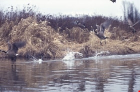
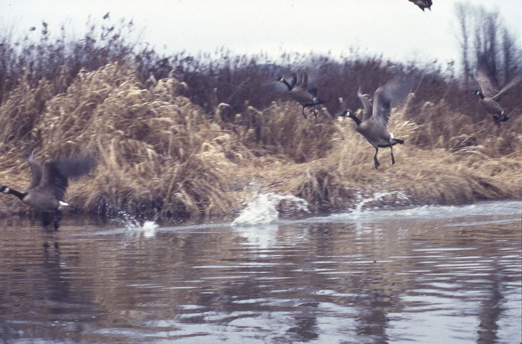
- File consists of photographs of Burnaby Lake and Still Creek, with an oil can and other debris in the water. Also included in the file are photographs of Canadian geese taking off and a man and woman kayaking on Still Creek.
- Repository
- City of Burnaby Archives
- Date
- February 3, 1998
- Collection/Fonds
- Doreen Lawson fonds
- Physical Description
- 18 photographs : col. slides ; 35 mm
- Description Level
- File
- Record No.
- 605-017
- Access Restriction
- No restrictions
- Reproduction Restriction
- No restrictions
- Accession Number
- 2003-30
- Scope and Content
- File consists of photographs of Burnaby Lake and Still Creek, with an oil can and other debris in the water. Also included in the file are photographs of Canadian geese taking off and a man and woman kayaking on Still Creek.
- Subjects
- Geographic Features - Lakes and Ponds
- Geographic Features - Forests
- Animals - Birds
- Recreational Activities
- Names
- Lawson, Doreen A.
- Media Type
- Photograph
- Photographer
- Lawson, Doreen A.
- Notes
- Title based on contents of photographs
- Geographic Access
- Burnaby Lake
- Historic Neighbourhood
- Burnaby Lake (Historic Neighbourhood)
- Planning Study Area
- Burnaby Lake Area
Images
![Survey and Subdivision plans in New Westminster District Group 1 – Burnaby
, [1908] thumbnail](/media/hpo/_Data/_BVM_Cartographic_Material/1977/1977_0093_0004a_001.jpg?width=280)
Survey and Subdivision plans in New Westminster District Group 1 – Burnaby
https://search.heritageburnaby.ca/link/museumdescription6973
- Repository
- Burnaby Village Museum
- Date
- [1908]
- Collection/Fonds
- Burnaby Village Museum Map collection
- Description Level
- File
- Physical Description
- 10 plans : blueprint ink on paper mounted on 2 sides of cardboard ; 76 cm x 102 cm
- Scope and Content
- Item consists of a large board of four New Westminster District Gp 1 - subdivision plans mounted on one side and six New Westminster District Gp 1 - subdivision plans mounted on the other side. Side A: 1. Blueprint "Plan / of - ReSubdivision / of / Lots 1-18 inclusive / Blocks 20 and 21 / in Sub…
- Repository
- Burnaby Village Museum
- Collection/Fonds
- Burnaby Village Museum Map collection
- Description Level
- File
- Physical Description
- 10 plans : blueprint ink on paper mounted on 2 sides of cardboard ; 76 cm x 102 cm
- Material Details
- Scales [between 1:792 and 1:4752]
- Index number on edge of board reads: "4"
- Scope and Content
- Item consists of a large board of four New Westminster District Gp 1 - subdivision plans mounted on one side and six New Westminster District Gp 1 - subdivision plans mounted on the other side. Side A: 1. Blueprint "Plan / of - ReSubdivision / of / Lots 1-18 inclusive / Blocks 20 and 21 / in Subdivision / of / Lot 53 -Gr.1 / New Westminster District" / "Subdivision Lot Numbers - Shown in Red". Plan is bordered by First Street / Jorgenson's Line / Fourth Avenue and Second Street with Fifith Avenue running through the centre. There is an index in the upper right corner of the plan. Planned is signed by "Peter Byrne" and "William R. Phillips" and dated July 28, 1908. (Geographic location: Burnaby) 2. Blueprint "Plan / of Subdivision / of / Lot 159 / and a Portion of Lot 158 / Group One / New Westminster District". Plan is bordered by Lots 96 and 97; South Wilson Street; North Arm Road and Lot 160 / Power House Road (Lot 155 A). B.C.E.R. Gilley Station is identified in the upper right corner of the plan. (Geographic location: Burnaby) 3. Blueprint plan identified as "Subdvs 10, L 88 and Lot 25, G. 1" Plan identifies Cumberland Street running from top to the bottom and a Ravine running alongside with the Jensen house, stable and barn. (Geographic location: Burnaby) 4. Blueprint Plan of "Lot 153. G. 1 /New Westminster District". Plan identifies the "New Westminster & Vancouver Tramway" and the "New Westminster and Vancouver Road" running through the plan of Lot 53. (Geographic location: Burnaby) Side B: 1. Blueprint plan of "Profile on Proposed North Rd. Diversion". 2. Blueprint plan (no title) showing wood lots north of Burnaby Lake and Brunette River and west of North Road. Various lots are identified as "Heavily Timbered" (Lot 57); "Splendid Fir and Cedar / Heavy Fir etc. / Fine Cedar" (Lots 143, 148); "Rough Light Timber," (Lot 56); "Some Fir and Cedar" (Lot 40). (Geographic location: Burnaby) 3. Blueprint "Plan / of Subdivision / of a Portion / of Lot 87, Gr.1 / New Westminster District". Plan is bordered by Burnaby Lake at the top and Hastings Road / Lot 86 at the bottom and Lot 90 to the east. "Albert J. Hill B.C.LotS." Annotation in ink reads: " J.A. Brownlee, B.C.L.S. / Subdivision / Map 1494 / Bd. 248". Plan is signed by "Peter Byrne, Reeve" (Geographic location: Burnaby) 4. Blueprint plan of Subdivisions along either side of Douglas Road including Lots 117; 119; 74; 80; 79 and 77. (Geographic location: Burnaby) 5. Blueprint "Plan / of / Subdivision of / Lot 27 / in Subdivision / of / Lot 30 / Group One / New Westminster District" Plan is bordered by Lot 26, Lot 28 and Hastings Rd. Lot 27 runs north of Edmonds Street. , "Albert J. Hill, B.C.LotS." (Geographic location: Burnaby) 6. Blueprint plan identified as a "Cultivated Orchard" including the names "W. Grace" and "G. Mead" located north of the North Arm Fraser River and west of "Twentieth Street_ City Boundary". Handwritten annotation in coloured pencil reads: "Portion of Lot 172" (Geographic location: Burnaby)
- Subjects
- Geographic Features - Forests
- Geographic Access
- Cumberland Street
- North Road
- Hastings Street
- Douglas Road
- Accession Code
- HV977.93.4
- Access Restriction
- No restrictions
- Reproduction Restriction
- No known restrictions
- Date
- [1908]
- Media Type
- Cartographic Material
- Historic Neighbourhood
- Burnaby Lake (Historic Neighbourhood)
- Fraser Arm (Historic Neighbourhood)
- Planning Study Area
- Douglas-Gilpin Area
- Burnaby Lake Area
- Scan Resolution
- 300
- Scale
- 72
- Notes
- Title based on contents of file
- Scale is measured in chains. (One chain equals 792 inches)
- The term "Lot" can also refer to a "District Lot”-
Images
![Survey and Subdivision plans in New Westminster District Group 1 – Burnaby
, [1908] thumbnail](/media/hpo/_Data/_BVM_Cartographic_Material/1977/1977_0093_0004a_001.jpg)
