More like '7050 Buller Ave'
Narrow Results By
Person / Organization
- Baldwin, Ruth 1
- Barnet Mill 1
- BC Society of Model Engineers (BCSME) 1
- Brentwood Shopping Centre 2
- British Columbia Electric Railway Company 1
- British Columbia Institute of Technology 2
- Brownlee, James Harrison 1
- Burnaby Art Gallery 1
- Burnaby City Hall 1
- Burnaby Fire Department 4
- Burnaby General Hospital 1
- Burnaby Historical Society 2
![Ken Shymka at Still Creek, [1999] thumbnail](/media/hpo/_Data/_Archives_Images/_Unrestricted/535/535-3319-2.jpg?width=280)
Ken Shymka at Still Creek
https://search.heritageburnaby.ca/link/archivedescription98252
- Repository
- City of Burnaby Archives
- Date
- [1999]
- Collection/Fonds
- Burnaby NewsLeader photograph collection
- Description Level
- File
- Physical Description
- 2 photographs (tiff) : col.
- Scope and Content
- File contains photographs of photographer Ken Shymka posing with his camera at Still Creek.
- Repository
- City of Burnaby Archives
- Date
- [1999]
- Collection/Fonds
- Burnaby NewsLeader photograph collection
- Physical Description
- 2 photographs (tiff) : col.
- Description Level
- File
- Record No.
- 535-3319
- Access Restriction
- No restrictions
- Reproduction Restriction
- No restrictions
- Accession Number
- 2018-12
- Scope and Content
- File contains photographs of photographer Ken Shymka posing with his camera at Still Creek.
- Subjects
- Occupations - Photographers
- Geographic Features - Creeks
- Geographic Features - Streams
- Photographic Tools and Equipment - Camera
- Media Type
- Photograph
- Notes
- Title based on contents of file
- Collected by editorial for use in a September 1999 issue of the Burnaby NewsLeader
- Geographic Access
- Still Creek
Images
![Ken Shymka at Still Creek, [1999] thumbnail](/media/hpo/_Data/_Archives_Images/_Unrestricted/535/535-3319-2.jpg)
![Mayor Derek Corrigan and Stéphane Dion at Burnaby Lake, [2005] thumbnail](/media/hpo/_Data/_Archives_Images/_Unrestricted/535/535-2159-1.jpg?width=280)
Mayor Derek Corrigan and Stéphane Dion at Burnaby Lake
https://search.heritageburnaby.ca/link/archivedescription96537
- Repository
- City of Burnaby Archives
- Date
- [2005]
- Collection/Fonds
- Burnaby NewsLeader photograph collection
- Description Level
- File
- Physical Description
- 2 photographs (tiff) : col.
- Scope and Content
- File contains photographs of Mayor Derek Corrigan touring Burnaby Lake with federal Minister of the Environment Stéphane Dion. Photographs depict Corrigan and Dion on the end of the walkway of Piper Spit, as Corrigan gestures out at Burnaby Lake, and walking the Rotary Walkway with Bill Cunningham.
- Repository
- City of Burnaby Archives
- Date
- [2005]
- Collection/Fonds
- Burnaby NewsLeader photograph collection
- Physical Description
- 2 photographs (tiff) : col.
- Description Level
- File
- Record No.
- 535-2159
- Access Restriction
- No restrictions
- Reproduction Restriction
- No restrictions
- Accession Number
- 2018-12
- Scope and Content
- File contains photographs of Mayor Derek Corrigan touring Burnaby Lake with federal Minister of the Environment Stéphane Dion. Photographs depict Corrigan and Dion on the end of the walkway of Piper Spit, as Corrigan gestures out at Burnaby Lake, and walking the Rotary Walkway with Bill Cunningham.
- Subjects
- Officials - Mayors and Reeves
- Officials - Elected Officials
- Geographic Features - Parks
- Geographic Features - Lakes and Ponds
- Names
- Corrigan, Derek
- Media Type
- Photograph
- Photographer
- Bartel, Mario
- Notes
- Title based on caption
- Collected by editorial for use in a March 2005 issue of the Burnaby NewsLeader
- Caption from metadata for 535-2159-1: "Burnaby mayor Derek Corrigan shows off Burnaby Lake to federal Minister of the Environment, Stephane Dion, during a tour a Piper Spit, part of the city of Burnaby's ongoing quest for funding to dredge the lake."
- Caption from metadata for 535-2159-2: "Burnaby mayor Derek Corrigan shows off Burnaby Lake to federal Minister of the Environment, Stephane Dion, and Bill Cunningham, during a tour along Piper Spit as part of the city of Burnaby's ongoing efforts to secure funding to dredge the lake."
- Geographic Access
- Burnaby Lake
- Burnaby Lake Regional Nature Park
- Historic Neighbourhood
- Burnaby Lake (Historic Neighbourhood)
- Planning Study Area
- Burnaby Lake Area
Images
![Mayor Derek Corrigan and Stéphane Dion at Burnaby Lake, [2005] thumbnail](/media/hpo/_Data/_Archives_Images/_Unrestricted/535/535-2159-1.jpg)
![MP Peter Julian at Burnaby Lake, [2005] thumbnail](/media/hpo/_Data/_Archives_Images/_Unrestricted/535/535-1873-2.jpg?width=280)
MP Peter Julian at Burnaby Lake
https://search.heritageburnaby.ca/link/archivedescription96176
- Repository
- City of Burnaby Archives
- Date
- [2005]
- Collection/Fonds
- Burnaby NewsLeader photograph collection
- Description Level
- File
- Physical Description
- 2 photographs (tiff) : col.
- Scope and Content
- File contains photographs of Burnaby/New Westminster MP Peter Julian posing on a dock by Burnaby Lake and in the rowing pavilion during a press conference related to the federal government's denial of funding for a dredging project.
- Repository
- City of Burnaby Archives
- Date
- [2005]
- Collection/Fonds
- Burnaby NewsLeader photograph collection
- Physical Description
- 2 photographs (tiff) : col.
- Description Level
- File
- Record No.
- 535-1873
- Access Restriction
- No restrictions
- Reproduction Restriction
- No restrictions
- Accession Number
- 2018-12
- Scope and Content
- File contains photographs of Burnaby/New Westminster MP Peter Julian posing on a dock by Burnaby Lake and in the rowing pavilion during a press conference related to the federal government's denial of funding for a dredging project.
- Subjects
- Geographic Features - Lakes and Ponds
- Geographic Features - Parks
- Officials - Elected Officials
- Media Type
- Photograph
- Photographer
- Bartel, Mario
- Notes
- Title based on caption
- Collected by editorial for use in a January 2005 issue of the Burnaby NewsLeader
- Caption from metadata for 535-1873-1: "Burnaby/New Westminster MP Peter Julian says he can't understand why the federal government would deny funding for a dredging project in Burnaby Lake when it approved a similar project for a lake in Saskatchewan."
- Caption from metadata for 535-1873-2: "Burnaby/New Westminster MP Peter Julian gestures towards Burnaby Lake during a news conference at the rowing pavillion to question the federal government's funding of a dredging project at a similar lake in Saskatchewan, while it won't assist a plan to save Burnaby Lake."
- Geographic Access
- Burnaby Lake
- Burnaby Lake Regional Nature Park
- Historic Neighbourhood
- Burnaby Lake (Historic Neighbourhood)
- Planning Study Area
- Burnaby Lake Area
Images
![MP Peter Julian at Burnaby Lake, [2005] thumbnail](/media/hpo/_Data/_Archives_Images/_Unrestricted/535/535-1873-2.jpg)
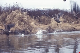
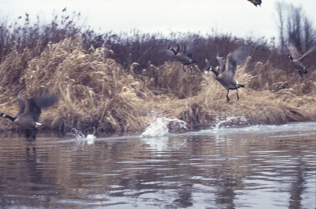
Still Creek and Burnaby Lake photographs
https://search.heritageburnaby.ca/link/archivedescription91584
- Repository
- City of Burnaby Archives
- Date
- February 3, 1998
- Collection/Fonds
- Doreen Lawson fonds
- Description Level
- File
- Physical Description
- 18 photographs : col. slides ; 35 mm
- Scope and Content
- File consists of photographs of Burnaby Lake and Still Creek, with an oil can and other debris in the water. Also included in the file are photographs of Canadian geese taking off and a man and woman kayaking on Still Creek.
- Repository
- City of Burnaby Archives
- Date
- February 3, 1998
- Collection/Fonds
- Doreen Lawson fonds
- Physical Description
- 18 photographs : col. slides ; 35 mm
- Description Level
- File
- Record No.
- 605-017
- Access Restriction
- No restrictions
- Reproduction Restriction
- No restrictions
- Accession Number
- 2003-30
- Scope and Content
- File consists of photographs of Burnaby Lake and Still Creek, with an oil can and other debris in the water. Also included in the file are photographs of Canadian geese taking off and a man and woman kayaking on Still Creek.
- Subjects
- Geographic Features - Lakes and Ponds
- Geographic Features - Forests
- Animals - Birds
- Recreational Activities
- Names
- Lawson, Doreen A.
- Media Type
- Photograph
- Photographer
- Lawson, Doreen A.
- Notes
- Title based on contents of photographs
- Geographic Access
- Burnaby Lake
- Historic Neighbourhood
- Burnaby Lake (Historic Neighbourhood)
- Planning Study Area
- Burnaby Lake Area
Images
![Trans Canada Trail in North Burnaby, [2000] thumbnail](/media/hpo/_Data/_Archives_Images/_Unrestricted/535/535-2117-1.jpg?width=280)
Trans Canada Trail in North Burnaby
https://search.heritageburnaby.ca/link/archivedescription96493
- Repository
- City of Burnaby Archives
- Date
- [2000]
- Collection/Fonds
- Burnaby NewsLeader photograph collection
- Description Level
- File
- Physical Description
- 2 photographs (tiff) : col.
- Scope and Content
- File contains photographs of Ruth Hardy, Anita Loy, and Trudy Mile walking the Trans Canada Trail in North Burnaby. Photographs depict them enjoying a view of the Burrard Inlet from the Heights Trail leg and walking past a trail marker that reads: "The Heights Trail."
- Repository
- City of Burnaby Archives
- Date
- [2000]
- Collection/Fonds
- Burnaby NewsLeader photograph collection
- Physical Description
- 2 photographs (tiff) : col.
- Description Level
- File
- Record No.
- 535-2117
- Access Restriction
- No restrictions
- Reproduction Restriction
- No restrictions
- Accession Number
- 2018-12
- Scope and Content
- File contains photographs of Ruth Hardy, Anita Loy, and Trudy Mile walking the Trans Canada Trail in North Burnaby. Photographs depict them enjoying a view of the Burrard Inlet from the Heights Trail leg and walking past a trail marker that reads: "The Heights Trail."
- Media Type
- Photograph
- Photographer
- Bartel, Mario
- Notes
- Title based on caption
- Collected by editorial for use in a March 2000 issue of the Burnaby NewsLeader
- Caption from metadata for 535-2117-1: "Ruth Hardy, Anita Loy and Trudy Mile enjoy some of the views along the Heights Trail leg of the Trans Canada Trail, as it winds along Burrard Inlet."
- Caption from metadata for 535-2117-2: "Ruth Hardy, Trudy Mile and Anita Loy get a little exercise along the Trans Canada Trail as it winds through North Burnaby."
- Geographic Access
- Burrard Inlet
- Burnaby Heights Park
- Historic Neighbourhood
- Vancouver Heights (Historic Neighbourhood)
- Planning Study Area
- Burnaby Heights Area
Images
![Trans Canada Trail in North Burnaby, [2000] thumbnail](/media/hpo/_Data/_Archives_Images/_Unrestricted/535/535-2117-1.jpg)
8357 Tenth Avenue, 8350 and 8353 Eleventh Avenue
https://search.heritageburnaby.ca/link/archivedescription93724
- Repository
- City of Burnaby Archives
- Date
- 1989
- Collection/Fonds
- Grover, Elliott & Co. Ltd. fonds
- Description Level
- File
- Physical Description
- 24 photographs : col. negatives ; 35 mm
- Scope and Content
- Photographs of the exterior of the low-rise apartment complex located at 8357 10th Avenue and 8350 and 8353 11th Avenue and the laneway running between the buildings.
- Repository
- City of Burnaby Archives
- Date
- 1989
- Collection/Fonds
- Grover, Elliott & Co. Ltd. fonds
- Physical Description
- 24 photographs : col. negatives ; 35 mm
- Description Level
- File
- Record No.
- 622-013
- Access Restriction
- No restrictions
- Reproduction Restriction
- No restrictions
- Accession Number
- 2017-39
- Scope and Content
- Photographs of the exterior of the low-rise apartment complex located at 8357 10th Avenue and 8350 and 8353 11th Avenue and the laneway running between the buildings.
- Media Type
- Photograph
- Notes
- Transcribed title
- Title transcribed from original print envelope
- Geographic Access
- 10th Avenue
- 11th Avenue
- Street Address
- 8357 10th Avenue
- 8350 11th Avenue
- 8353 11th Avenue
- Historic Neighbourhood
- East Burnaby (Historic Neighbourhood)
- Planning Study Area
- Cariboo-Armstrong Area

Burnaby Central - North - N. Shore Mtns.
https://search.heritageburnaby.ca/link/archivedescription91709
- Repository
- City of Burnaby Archives
- Date
- May 1998 - June 1998
- Collection/Fonds
- Doreen Lawson fonds
- Description Level
- File
- Physical Description
- 12 photographs : col. slides ; 35 mm
- Scope and Content
- File consists of landscape photographs of North Burnaby with snow-covered North Shore mountains visible in the distance. The photographs were taken from the Central Burnaby area.
- Repository
- City of Burnaby Archives
- Date
- May 1998 - June 1998
- Collection/Fonds
- Doreen Lawson fonds
- Physical Description
- 12 photographs : col. slides ; 35 mm
- Description Level
- File
- Record No.
- 618-027
- Access Restriction
- No restrictions
- Reproduction Restriction
- No restrictions
- Accession Number
- 2015-15
- Scope and Content
- File consists of landscape photographs of North Burnaby with snow-covered North Shore mountains visible in the distance. The photographs were taken from the Central Burnaby area.
- Media Type
- Photograph
- Photographer
- Lawson, Doreen A.
- Notes
- Transcribed title
- Title transcribed from slide sheet label
- Historic Neighbourhood
- Burnaby Lake (Historic Neighbourhood)
Images

![Burnaby Lake Sports Complex observation tower, [2002] thumbnail](/media/hpo/_Data/_Archives_Images/_Unrestricted/535/535-2923-1.jpg?width=280)
Burnaby Lake Sports Complex observation tower
https://search.heritageburnaby.ca/link/archivedescription97607
- Repository
- City of Burnaby Archives
- Date
- [2002]
- Collection/Fonds
- Burnaby NewsLeader photograph collection
- Description Level
- File
- Physical Description
- 2 photographs (tiff) : col.
- Scope and Content
- File contains photographs of Tom Sadler, an employee with the City of Burnaby Parks and Recreation Department, at the new and under-construction observation tower at the Burnaby Lake Sports Complex. Photographs depict Sadler looking over the fields of the Burnaby Lake Sports Complex from the tower,…
- Repository
- City of Burnaby Archives
- Date
- [2002]
- Collection/Fonds
- Burnaby NewsLeader photograph collection
- Physical Description
- 2 photographs (tiff) : col.
- Description Level
- File
- Record No.
- 535-2923
- Access Restriction
- No restrictions
- Reproduction Restriction
- No restrictions
- Accession Number
- 2018-12
- Scope and Content
- File contains photographs of Tom Sadler, an employee with the City of Burnaby Parks and Recreation Department, at the new and under-construction observation tower at the Burnaby Lake Sports Complex. Photographs depict Sadler looking over the fields of the Burnaby Lake Sports Complex from the tower, and inside the tower, demonstrating the tower's sliding windows.
- Subjects
- Buildings - Recreational - Sports
- Geographic Features - Athletic Fields
- Occupations - Civic Workers
- Media Type
- Photograph
- Photographer
- Bartel, Mario
- Notes
- Title based on caption
- Collected by editorial for use in a January 2002 issue of the Burnaby NewsLeader
- Caption from metadata for 535-2923-1: "Tom Sadler, of Burnaby's Parks and Rec Department, gets a spotter's-eye view of the playing fields at Burnaby Lake Sports Complex from the roof of the new viewing tower that is nearing completion. He says the rooftop area will be particularly useful for spotters working football games. The tower looks out over fields one and three."
- Caption from metadata for 535-2923-2: "Tom Sadler, of Burnaby's Parks and Rec Department, demonstrates how the sliding windows in the new observation tower at Burnaby Lake Sports Complex can open to give an unobstructed view to the playing fields below. The windows had to be specially imported from Germany, and allows a tv camera to be set up inside the tower, safe from the elements, and still shoot the whole field."
- Geographic Access
- Kensington Avenue
- Burnaby Lake Sports Complex
- Historic Neighbourhood
- Burnaby Lake (Historic Neighbourhood)
- Planning Study Area
- Ardingley-Sprott Area
Images
![Burnaby Lake Sports Complex observation tower, [2002] thumbnail](/media/hpo/_Data/_Archives_Images/_Unrestricted/535/535-2923-1.jpg)
![Hotel guys, [1999] thumbnail](/media/hpo/_Data/_Archives_Images/_Unrestricted/535/535-3273-1.jpg?width=280)
Hotel guys
https://search.heritageburnaby.ca/link/archivedescription98195
- Repository
- City of Burnaby Archives
- Date
- [1999]
- Collection/Fonds
- Burnaby NewsLeader photograph collection
- Description Level
- File
- Physical Description
- 2 photographs (tiff) : col.
- Scope and Content
- File contains photographs of two unidentified people standing inside of an emptied-out hotel room and posing in the parking lot in front of an unmarked building.
- Repository
- City of Burnaby Archives
- Date
- [1999]
- Collection/Fonds
- Burnaby NewsLeader photograph collection
- Physical Description
- 2 photographs (tiff) : col.
- Description Level
- File
- Record No.
- 535-3273
- Access Restriction
- No restrictions
- Reproduction Restriction
- No restrictions
- Accession Number
- 2018-12
- Scope and Content
- File contains photographs of two unidentified people standing inside of an emptied-out hotel room and posing in the parking lot in front of an unmarked building.
- Media Type
- Photograph
- Notes
- Title based on original file name
- Collected by editorial for use in a July 1999 issue of the Burnaby NewsLeader
Images
![Hotel guys, [1999] thumbnail](/media/hpo/_Data/_Archives_Images/_Unrestricted/535/535-3273-1.jpg)

Lougheed Mall skyline at night
https://search.heritageburnaby.ca/link/archivedescription91699
- Repository
- City of Burnaby Archives
- Date
- 1986-1989
- Collection/Fonds
- Doreen Lawson fonds
- Description Level
- File
- Physical Description
- 6 photographs : col. slides ; 35 mm
- Scope and Content
- File consists of scenic photographs of Burnaby Lake at sunset and nighttime with the Lougheed Mall skyline lit up in the distance.
- Repository
- City of Burnaby Archives
- Date
- 1986-1989
- Collection/Fonds
- Doreen Lawson fonds
- Physical Description
- 6 photographs : col. slides ; 35 mm
- Description Level
- File
- Record No.
- 618-017
- Access Restriction
- No restrictions
- Reproduction Restriction
- No restrictions
- Accession Number
- 2015-15
- Scope and Content
- File consists of scenic photographs of Burnaby Lake at sunset and nighttime with the Lougheed Mall skyline lit up in the distance.
- Media Type
- Photograph
- Photographer
- Lawson, Doreen A.
- Notes
- Title based on contents of photographs
- Historic Neighbourhood
- Burnaby Lake (Historic Neighbourhood)
- Planning Study Area
- Burnaby Lake Area
Images

![Moscrop Secondary School, [2000] thumbnail](/media/hpo/_Data/_Archives_Images/_Unrestricted/535/535-2124-3.jpg?width=280)
Moscrop Secondary School
https://search.heritageburnaby.ca/link/archivedescription96500
- Repository
- City of Burnaby Archives
- Date
- [2000]
- Collection/Fonds
- Burnaby NewsLeader photograph collection
- Description Level
- File
- Physical Description
- 3 photographs (tiff) : b&w
- Scope and Content
- File contains photographs of Moscrop Secondary School. Photographs depict portables outside the school, with residential homes visible in the background; the school parking lot; and students gathering on the stairs and in the front lobby of the school.
- Repository
- City of Burnaby Archives
- Date
- [2000]
- Collection/Fonds
- Burnaby NewsLeader photograph collection
- Physical Description
- 3 photographs (tiff) : b&w
- Description Level
- File
- Record No.
- 535-2124
- Access Restriction
- No restrictions
- Reproduction Restriction
- No restrictions
- Accession Number
- 2018-12
- Scope and Content
- File contains photographs of Moscrop Secondary School. Photographs depict portables outside the school, with residential homes visible in the background; the school parking lot; and students gathering on the stairs and in the front lobby of the school.
- Names
- Moscrop Secondary School
- Media Type
- Photograph
- Notes
- Title based on caption
- Collected by editorial for use in a March 2000 issue of the Burnaby NewsLeader
- Geographic Access
- Moscrop Street
- Street Address
- 4433 Moscrop Street
- Planning Study Area
- Cascade-Schou Area
Images
![Moscrop Secondary School, [2000] thumbnail](/media/hpo/_Data/_Archives_Images/_Unrestricted/535/535-2124-3.jpg)
3183 Norland Rd
https://search.heritageburnaby.ca/link/archivedescription94298
- Repository
- City of Burnaby Archives
- Date
- November 1993
- Collection/Fonds
- Grover, Elliott & Co. Ltd. fonds
- Description Level
- File
- Physical Description
- 44 photographs : col. negatives ; 35 mm
- Scope and Content
- Photographs of the exterior of the two-storey industrial property located at 3183 Norland Avenue. Industrial Movers Ltd. and Pacific are the tenants of the property.
- Repository
- City of Burnaby Archives
- Date
- November 1993
- Collection/Fonds
- Grover, Elliott & Co. Ltd. fonds
- Physical Description
- 44 photographs : col. negatives ; 35 mm
- Description Level
- File
- Record No.
- 622-083
- Access Restriction
- No restrictions
- Reproduction Restriction
- No restrictions
- Accession Number
- 2017-39
- Scope and Content
- Photographs of the exterior of the two-storey industrial property located at 3183 Norland Avenue. Industrial Movers Ltd. and Pacific are the tenants of the property.
- Subjects
- Buildings - Industrial
- Media Type
- Photograph
- Notes
- Transcribed title
- Title transcribed from envelope photographs were originally housed in
- File no. 93-474-B
- Photographer identified as "D.E."
- Geographic Access
- Norland Avenue
- Street Address
- 3183 Norland Avenue
- Historic Neighbourhood
- Burnaby Lake (Historic Neighbourhood)
- Planning Study Area
- Ardingley-Sprott Area
4200 Phillips Ave
https://search.heritageburnaby.ca/link/archivedescription94317
- Repository
- City of Burnaby Archives
- Date
- September 1994
- Collection/Fonds
- Grover, Elliott & Co. Ltd. fonds
- Description Level
- File
- Physical Description
- 24 photographs : col. negatives ; 35 mm
- Scope and Content
- Photographs of the exterior of a single-storey industrial building located at 4200 Phillips Avenue - an address that no longer exists.
- Repository
- City of Burnaby Archives
- Date
- September 1994
- Collection/Fonds
- Grover, Elliott & Co. Ltd. fonds
- Physical Description
- 24 photographs : col. negatives ; 35 mm
- Description Level
- File
- Record No.
- 622-102
- Access Restriction
- No restrictions
- Reproduction Restriction
- No restrictions
- Accession Number
- 2017-39
- Scope and Content
- Photographs of the exterior of a single-storey industrial building located at 4200 Phillips Avenue - an address that no longer exists.
- Subjects
- Buildings - Industrial
- Media Type
- Photograph
- Notes
- Transcribed title
- Title transcribed from envelope photographs were originally housed in
- File no. 94-329-B
- Photographer identified as "J.C."
- Geographic Access
- Phillips Avenue
- Historic Neighbourhood
- Lozells (Historic Neighbourhood)
- Planning Study Area
- Government Road Area
5324 Thorne Ave
https://search.heritageburnaby.ca/link/archivedescription93762
- Repository
- City of Burnaby Archives
- Date
- June 12, 1992
- Collection/Fonds
- Grover, Elliott & Co. Ltd. fonds
- Description Level
- File
- Physical Description
- 120 photographs : col. negatives ; 35 mm
- Scope and Content
- Photographs of an industrial property located at 5324 Thorne Avenue - an address than no longer exists.
- Repository
- City of Burnaby Archives
- Date
- June 12, 1992
- Collection/Fonds
- Grover, Elliott & Co. Ltd. fonds
- Physical Description
- 120 photographs : col. negatives ; 35 mm
- Description Level
- File
- Record No.
- 622-047
- Access Restriction
- No restrictions
- Reproduction Restriction
- No restrictions
- Accession Number
- 2017-39
- Scope and Content
- Photographs of an industrial property located at 5324 Thorne Avenue - an address than no longer exists.
- Subjects
- Buildings - Industrial
- Media Type
- Photograph
- Notes
- Transcribed title
- Title transcribed from envelope photographs were originally housed in
- File no. 92-224-I
- Note adhered to 622-047-001 print reads: "11 / The manufacturing plant [illegible], southwest from the northweast corner of the site".
- Note adhered to 622-047-5 print reads: "17 / view south along the east side of the property from Thorne Avenue".
- Note adhered to 622-047-9 print reads: "18 / The canopy at loading area and shed addition of the [illegible] and of the building".
- Note adhered to 622-047-13 print reads: "19 / View of the interior of the building looking towards to west".
- Note adhered to 622-047-17 print reads: "23 / view east across the site immediately south of the building".
- Note adhered to 622-047-21 print reads: "22 / view looking north west twoards the south facade".
- Note adhered to 622-047-25 print reads: "8 / The freestanding office building adjacent to Thorne Avenue and Wiggins Street".
- Note adhered to 622-047-29 print reads: "9 / View of its front entr [sid] and the office building".
- Note adhered to 622-047-33 reads: "10 / View west towards the office building from the main vehicle entr [sic] at Thorne Avenue".
- Note adhered to 622-047-37 print reads: "14 / View east across the north yard area".
- Note adhered to 622-047-41 print reads: "12 / View of the north facade looking south."
- Note adhered to 622-047-45 print reads: "13 / View west across the north yard area".
- Note adhered to 622-047-49 print reads: "20 / The [illegible] building".
- Note adhered to 622-047-53 print reads: "26 / View northeast from the west property line".
- Note adhered to 622-047-57 print reads: "21 / View looking northeast at the south facade".
- Note adhered to 622-047-61 print reads: "16 / View north along the west side of the manufacturing building".
- Note adhered to 622-047-65 print reads: "15 / View of the north west corner of the manufacturing building".
- Note adhered to 622-047-69 print reads: "3 / View west along Thorne Avenue from the east side of the property".
- Note adhered to 622-047-73 print reads: "25 / View north from the southeast corner of the property".
- Note adhered to 622-047-77 print reads: "30 / View of the dock looking southeast from the property".
- Note adhered to 622-047-81 print reads: "24 / View north from the southwest corner of the property".
- Note adhered to 622-047-85 print reads: "27 / The barge dock at the southwest corner of the site".
- Note adhered to 622-047-89 print reads: "29 / View east along the river front".
- Note adhered to 622-047-93 print reads: "28 / View of the dolphins and mooring area".
- Note adhered to 622-047-97 print reads: "4 / View west along [illegible] Avenue past the entrance to the north parking lot".
- Note adhered to 622-047-101 print reads: "2 / View southwest from Thorne Avenue".
- Note adhered to 622-047-105 print reads: "5 / View west across the north parking lot".
- Note adhered to 622-047-113 print reads: "6 / View southeast from the north parking lot".
- Photographer identified as "D.E."
- Geographic Access
- Thorne Avenue
- Historic Neighbourhood
- Fraser Arm (Historic Neighbourhood)
- Planning Study Area
- Big Bend Area
5707 Sidley Street
https://search.heritageburnaby.ca/link/archivedescription93726
- Repository
- City of Burnaby Archives
- Date
- 1989
- Collection/Fonds
- Grover, Elliott & Co. Ltd. fonds
- Description Level
- File
- Physical Description
- 16 photographs : col. negatives ; 35 mm
- Scope and Content
- Photographs of the exterior of an industrial development located at 5707 Sidley Street.
- Repository
- City of Burnaby Archives
- Date
- 1989
- Collection/Fonds
- Grover, Elliott & Co. Ltd. fonds
- Physical Description
- 16 photographs : col. negatives ; 35 mm
- Description Level
- File
- Record No.
- 622-014
- Access Restriction
- No restrictions
- Reproduction Restriction
- No restrictions
- Accession Number
- 2017-39
- Scope and Content
- Photographs of the exterior of an industrial development located at 5707 Sidley Street.
- Subjects
- Buildings - Industrial
- Media Type
- Photograph
- Notes
- Transcribed title
- Title transcribed from note on verso of photograph
- Geographic Access
- Sidley Street
- Street Address
- 5707 Sidley Street
- Historic Neighbourhood
- Alta Vista (Historic Neighbourhood)
- Planning Study Area
- Clinton-Glenwood Area
6501 Sprott St
https://search.heritageburnaby.ca/link/archivedescription93771
- Repository
- City of Burnaby Archives
- Date
- September 1992
- Collection/Fonds
- Grover, Elliott & Co. Ltd. fonds
- Description Level
- File
- Physical Description
- 48 photographs : col. negatives ; 35 mm
- Scope and Content
- Photographs of the industrial property located at 6501 Sprott Street, which includestwo buildings and a parking lot.
- Repository
- City of Burnaby Archives
- Date
- September 1992
- Collection/Fonds
- Grover, Elliott & Co. Ltd. fonds
- Physical Description
- 48 photographs : col. negatives ; 35 mm
- Description Level
- File
- Record No.
- 622-055
- Access Restriction
- No restrictions
- Reproduction Restriction
- No restrictions
- Accession Number
- 2017-39
- Scope and Content
- Photographs of the industrial property located at 6501 Sprott Street, which includestwo buildings and a parking lot.
- Subjects
- Buildings - Industrial
- Media Type
- Photograph
- Notes
- Transcribed title
- Title transcribed from envelope photographs were originally housed in
- File no. 92-327-B
- Photographer identified as "D.C."
- Geographic Access
- Sprott Street
- Street Address
- 6501 Sprott Street
- Historic Neighbourhood
- Burnaby Lake (Historic Neighbourhood)
- Planning Study Area
- Ardingley-Sprott Area
6741 Cariboo Rd Burnaby
https://search.heritageburnaby.ca/link/archivedescription94308
- Repository
- City of Burnaby Archives
- Date
- April 1994
- Collection/Fonds
- Grover, Elliott & Co. Ltd. fonds
- Description Level
- File
- Physical Description
- 25 photographs : col. negatives ; 35 mm
- Scope and Content
- Photographs of an undeveloped property, single-storey industrial building, and railroad crossing.
- Repository
- City of Burnaby Archives
- Date
- April 1994
- Collection/Fonds
- Grover, Elliott & Co. Ltd. fonds
- Physical Description
- 25 photographs : col. negatives ; 35 mm
- Description Level
- File
- Record No.
- 622-093
- Access Restriction
- No restrictions
- Reproduction Restriction
- No restrictions
- Accession Number
- 2017-39
- Scope and Content
- Photographs of an undeveloped property, single-storey industrial building, and railroad crossing.
- Media Type
- Photograph
- Photographer
- Young, Richard
- Notes
- Transcribed title
- Title transcribed from envelope photographs were originally housed in
- File no. 94-115-B
- Geographic Access
- Cariboo Road
- Street Address
- 6741 Cariboo Road
- Planning Study Area
- Burnaby Lake Area
7260 Winston St.
https://search.heritageburnaby.ca/link/archivedescription94312
- Repository
- City of Burnaby Archives
- Date
- June 1994
- Collection/Fonds
- Grover, Elliott & Co. Ltd. fonds
- Description Level
- File
- Physical Description
- 49 photographs : col. negatives ; 35 mm
- Scope and Content
- Photographs of the exterior of Unisource, located at 7260 Winston Street.
- Repository
- City of Burnaby Archives
- Date
- June 1994
- Collection/Fonds
- Grover, Elliott & Co. Ltd. fonds
- Physical Description
- 49 photographs : col. negatives ; 35 mm
- Description Level
- File
- Record No.
- 622-097
- Access Restriction
- No restrictions
- Reproduction Restriction
- No restrictions
- Accession Number
- 2017-39
- Scope and Content
- Photographs of the exterior of Unisource, located at 7260 Winston Street.
- Subjects
- Buildings - Industrial
- Media Type
- Photograph
- Notes
- Transcribed title
- Title transcribed from envelope photographs were originally housed in
- File no. 94-214-B
- Photographer identified as "K.H."
- Geographic Access
- Winston Street
- Street Address
- 7260 Winston Street
- Historic Neighbourhood
- Lozells (Historic Neighbourhood)
- Planning Study Area
- Government Road Area
8575 Government Street
https://search.heritageburnaby.ca/link/archivedescription93738
- Repository
- City of Burnaby Archives
- Date
- March 1989
- Collection/Fonds
- Grover, Elliott & Co. Ltd. fonds
- Description Level
- File
- Physical Description
- 4 photographs : col. ; 10 cm x 15 cm
- Scope and Content
- Photographs of the industrial complex located at 8575 Government Street under construction.
- Repository
- City of Burnaby Archives
- Date
- March 1989
- Collection/Fonds
- Grover, Elliott & Co. Ltd. fonds
- Physical Description
- 4 photographs : col. ; 10 cm x 15 cm
- Description Level
- File
- Record No.
- 622-023
- Access Restriction
- No restrictions
- Reproduction Restriction
- No restrictions
- Accession Number
- 2017-39
- Scope and Content
- Photographs of the industrial complex located at 8575 Government Street under construction.
- Media Type
- Photograph
- Notes
- Transcribed title
- Title transcribed from sticky note adhered to photograph 622-023-1
- File no. 89-125-B
- Photograph 622-023-1 caption reads: "View north from Government Street"
- Photograph 622-023-2 caption reads: "Eastern view along Government Street; Note Gaglardi Way overpass"
- Photograph 622-023-3 caption reads: "Rear of building"
- Photograph 622-023-4 caption reads: "Southern view along main facade"
- Photograph captions transcribed from the paper on which the photographs were originally adhered.
- Geographic Access
- Government Street
- Street Address
- 8575 Government Street
- Planning Study Area
- Lake City Area
8651 Eastlake Drive
https://search.heritageburnaby.ca/link/archivedescription93742
- Repository
- City of Burnaby Archives
- Date
- July 26, 1989
- Collection/Fonds
- Grover, Elliott & Co. Ltd. fonds
- Description Level
- File
- Physical Description
- 6 photographs : col. negatives ; 35 mm + 7 photographs : col. ; 10 cm x 15 cm
- Scope and Content
- Photographs of various industrial properties in Burnaby, BC. Tenants of the buildings include: Western Unitool, Baron Glass, Baxter, and Barton of Canada Ltd.
- Repository
- City of Burnaby Archives
- Date
- July 26, 1989
- Collection/Fonds
- Grover, Elliott & Co. Ltd. fonds
- Physical Description
- 6 photographs : col. negatives ; 35 mm + 7 photographs : col. ; 10 cm x 15 cm
- Description Level
- File
- Record No.
- 622-027
- Access Restriction
- No restrictions
- Reproduction Restriction
- No restrictions
- Accession Number
- 2017-39
- Scope and Content
- Photographs of various industrial properties in Burnaby, BC. Tenants of the buildings include: Western Unitool, Baron Glass, Baxter, and Barton of Canada Ltd.
- Media Type
- Photograph
- Notes
- Transcribed title
- Title transcribed from print envelope photographs were originally housed in
- File no. 89-298-B
- Note on original negative sleeve reads: "Comps/Ackland"