More like '"Argu-In" cabin on Mount Seymour'
Narrow Results By
Person / Organization
- Baldwin, Ruth 1
- Barnet Mill 1
- BC Society of Model Engineers (BCSME) 1
- Brentwood Shopping Centre 2
- British Columbia Electric Railway Company 1
- British Columbia Institute of Technology 2
- Brownlee, James Harrison 1
- Burnaby Art Gallery 1
- Burnaby City Hall 1
- Burnaby Fire Department 6
- Burnaby General Hospital 1
- Burnaby Historical Society 2
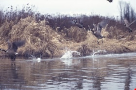
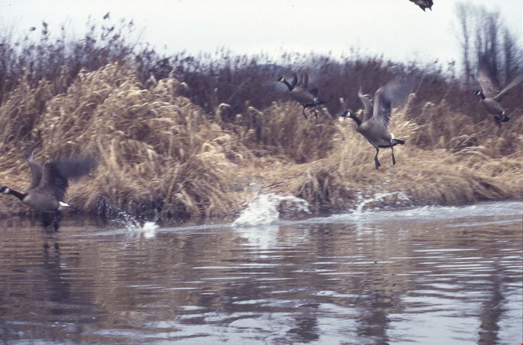
Still Creek and Burnaby Lake photographs
https://search.heritageburnaby.ca/link/archivedescription91584
- Repository
- City of Burnaby Archives
- Date
- February 3, 1998
- Collection/Fonds
- Doreen Lawson fonds
- Description Level
- File
- Physical Description
- 18 photographs : col. slides ; 35 mm
- Scope and Content
- File consists of photographs of Burnaby Lake and Still Creek, with an oil can and other debris in the water. Also included in the file are photographs of Canadian geese taking off and a man and woman kayaking on Still Creek.
- Repository
- City of Burnaby Archives
- Date
- February 3, 1998
- Collection/Fonds
- Doreen Lawson fonds
- Physical Description
- 18 photographs : col. slides ; 35 mm
- Description Level
- File
- Record No.
- 605-017
- Access Restriction
- No restrictions
- Reproduction Restriction
- No restrictions
- Accession Number
- 2003-30
- Scope and Content
- File consists of photographs of Burnaby Lake and Still Creek, with an oil can and other debris in the water. Also included in the file are photographs of Canadian geese taking off and a man and woman kayaking on Still Creek.
- Subjects
- Geographic Features - Lakes and Ponds
- Geographic Features - Forests
- Animals - Birds
- Recreational Activities
- Names
- Lawson, Doreen A.
- Media Type
- Photograph
- Photographer
- Lawson, Doreen A.
- Notes
- Title based on contents of photographs
- Geographic Access
- Burnaby Lake
- Historic Neighbourhood
- Burnaby Lake (Historic Neighbourhood)
- Planning Study Area
- Burnaby Lake Area
Images
6900 [and] 7000 bk Hastings St. / 7000 blk Pandora St. 200 [and] 300 blks Cliff Ave Burnaby
https://search.heritageburnaby.ca/link/archivedescription94205
- Repository
- City of Burnaby Archives
- Date
- November 1993 - December 1993
- Collection/Fonds
- Grover, Elliott & Co. Ltd. fonds
- Description Level
- File
- Physical Description
- 96 photographs : col. negatives ; 35 mm
- Scope and Content
- Photographs of various residential and commercial streets in Burnaby.
- Repository
- City of Burnaby Archives
- Date
- November 1993 - December 1993
- Collection/Fonds
- Grover, Elliott & Co. Ltd. fonds
- Physical Description
- 96 photographs : col. negatives ; 35 mm
- Description Level
- File
- Record No.
- 622-080
- Access Restriction
- No restrictions
- Reproduction Restriction
- No restrictions
- Accession Number
- 2017-39
- Scope and Content
- Photographs of various residential and commercial streets in Burnaby.
- Subjects
- Geographic Features - Roads
- Buildings - Residential - Apartments
- Buildings - Residential - Houses
- Buildings - Commercial
- Media Type
- Photograph
- Notes
- Transcribed title
- Title transcribed from envelope photographs were originally housed in
- File no. 93-455-B
- Note on negative envelope housing photographs 622-080-1 : 622-080-74 reads: "93-11-26 / Inlet Dr/Hastings, Bby, / 93-455-B"
- Note on negative envelope housing photographs 622-080-75 : 622-080-96 reads: "93-12-01 / Comp's / 93-455"
- Photographer identified as "K.H."
- Geographic Access
- Hastings Street
- Cliff Avenue
- Pandora Street
6088 Cassie Avenue
https://search.heritageburnaby.ca/link/archivedescription93717
- Repository
- City of Burnaby Archives
- Date
- 1987
- Collection/Fonds
- Grover, Elliott & Co. Ltd. fonds
- Description Level
- File
- Physical Description
- 14 photographs : col. negatives ; 35 mm + 5 photographs : col. ; 10 cm x 15 cm
- Scope and Content
- Photographs of the private residence and garden located at 6088 Cassie Avenue - an address that no longer exists.
- Repository
- City of Burnaby Archives
- Date
- 1987
- Collection/Fonds
- Grover, Elliott & Co. Ltd. fonds
- Physical Description
- 14 photographs : col. negatives ; 35 mm + 5 photographs : col. ; 10 cm x 15 cm
- Description Level
- File
- Record No.
- 622-006
- Access Restriction
- No restrictions
- Reproduction Restriction
- No restrictions
- Accession Number
- 2017-39
- Scope and Content
- Photographs of the private residence and garden located at 6088 Cassie Avenue - an address that no longer exists.
- Media Type
- Photograph
- Notes
- Transcribed title
- Title transcribed from original print envelope
- File no. 87-300-B
- Geographic Access
- Cassie Avenue
- Historic Neighbourhood
- Central Park (Historic Neighbourhood)
- Planning Study Area
- Maywood Area
Edmonds St + 18th Ave (SW of 16th Street)
https://search.heritageburnaby.ca/link/archivedescription93727
- Repository
- City of Burnaby Archives
- Date
- March 1989
- Collection/Fonds
- Grover, Elliott & Co. Ltd. fonds
- Description Level
- File
- Physical Description
- 14 photographs : col. negatives ; 35 mm
- Scope and Content
- Photographs of the intersections at Edmonds Street and 18th Avenue and Edmonds Street and 16th Avenue and an unidentified residential lane.
- Repository
- City of Burnaby Archives
- Date
- March 1989
- Collection/Fonds
- Grover, Elliott & Co. Ltd. fonds
- Physical Description
- 14 photographs : col. negatives ; 35 mm
- Description Level
- File
- Record No.
- 622-015
- Access Restriction
- No restrictions
- Reproduction Restriction
- No restrictions
- Accession Number
- 2017-39
- Scope and Content
- Photographs of the intersections at Edmonds Street and 18th Avenue and Edmonds Street and 16th Avenue and an unidentified residential lane.
- Media Type
- Photograph
- Notes
- Transcribed title
- Title transcribed from original print envelope
- Photographs 622-015-001 : 622-015-002 depict Edmonds Street and 16th Avenue, facing south
- Photographs 622-015-003 : 622-015-004 depict the view southwest along Edmonds Street
- Photographs 622-015-006 : 622-015-008 depict the view southeast along 16th Street
- Photographs 622-015-009 : 622-015-011 depict the view southwest along 18th Avenue
- Locations were identified using notes on verso of accompanying prints
- Geographic Access
- 18th Avenue
- Edmonds Street
- 16th Avenue
- Historic Neighbourhood
- Edmonds (Historic Neighbourhood)
- Planning Study Area
- Stride Avenue Area
2761 North Rd
https://search.heritageburnaby.ca/link/archivedescription94334
- Repository
- City of Burnaby Archives
- Date
- April 1995
- Collection/Fonds
- Grover, Elliott & Co. Ltd. fonds
- Description Level
- File
- Physical Description
- 24 photographs : col. negatives ; 35 mm
- Scope and Content
- Photographs of an undeveloped property located at 2761 North Road - an address that no longer exists. Three large billboards are posted at the edge of the property, facing onto the street.
- Repository
- City of Burnaby Archives
- Date
- April 1995
- Collection/Fonds
- Grover, Elliott & Co. Ltd. fonds
- Physical Description
- 24 photographs : col. negatives ; 35 mm
- Description Level
- File
- Record No.
- 622-119
- Access Restriction
- No restrictions
- Reproduction Restriction
- No restrictions
- Accession Number
- 2017-39
- Scope and Content
- Photographs of an undeveloped property located at 2761 North Road - an address that no longer exists. Three large billboards are posted at the edge of the property, facing onto the street.
- Media Type
- Photograph
- Photographer
- Young, Richard
- Notes
- Transcribed title
- Title transcribed from envelope photographs were originally housed in
- File no. 95-167-B
- Geographic Access
- North Road
- Historic Neighbourhood
- Burquitlam (Historic Neighbourhood)
- Planning Study Area
- Lyndhurst Area
7465 Mulberry Place
https://search.heritageburnaby.ca/link/archivedescription94305
- Repository
- City of Burnaby Archives
- Date
- February 1994
- Collection/Fonds
- Grover, Elliott & Co. Ltd. fonds
- Description Level
- File
- Physical Description
- 22 photographs : col. negatives ; 35 mm
- Scope and Content
- Photographs of an undeveloped, forested property located at 7465 Mulberry Place.
- Repository
- City of Burnaby Archives
- Date
- February 1994
- Collection/Fonds
- Grover, Elliott & Co. Ltd. fonds
- Physical Description
- 22 photographs : col. negatives ; 35 mm
- Description Level
- File
- Record No.
- 622-090
- Access Restriction
- No restrictions
- Reproduction Restriction
- No restrictions
- Accession Number
- 2017-39
- Scope and Content
- Photographs of an undeveloped, forested property located at 7465 Mulberry Place.
- Subjects
- Geographic Features - Forests
- Media Type
- Photograph
- Notes
- Transcribed title
- Title transcribed from envelope photographs were originally housed in
- File no. 94-051-B
- Photographer identified as "J.C."
- Geographic Access
- Mulberry Place
- Street Address
- 7465 Mulberry Place
- Historic Neighbourhood
- East Burnaby (Historic Neighbourhood)
- Planning Study Area
- Cariboo-Armstrong Area
8678 Greenall Ave
https://search.heritageburnaby.ca/link/archivedescription94335
- Repository
- City of Burnaby Archives
- Date
- April 1995
- Collection/Fonds
- Grover, Elliott & Co. Ltd. fonds
- Description Level
- File
- Physical Description
- 25 photographs : col. negatives ; 35 mm
- Scope and Content
- Photographs of a property located at 8678 Greenal Avenue.
- Repository
- City of Burnaby Archives
- Date
- April 1995
- Collection/Fonds
- Grover, Elliott & Co. Ltd. fonds
- Physical Description
- 25 photographs : col. negatives ; 35 mm
- Description Level
- File
- Record No.
- 622-120
- Access Restriction
- No restrictions
- Reproduction Restriction
- No restrictions
- Accession Number
- 2017-39
- Scope and Content
- Photographs of a property located at 8678 Greenal Avenue.
- Subjects
- Geographic Features - Forests
- Media Type
- Photograph
- Photographer
- Young, Richard
- Notes
- Transcribed title
- Title transcribed from envelope photographs were originally housed in
- File no. 95-171-B
- Geographic Access
- Greenall Avenue
- Street Address
- 8678 Greenall Avenue
- Historic Neighbourhood
- Fraser Arm (Historic Neighbourhood)
- Planning Study Area
- Big Bend Area
![Arborists in a forest, [1999] thumbnail](/media/hpo/_Data/_Archives_Images/_Unrestricted/535/535-3236-1.jpg?width=280)
Arborists in a forest
https://search.heritageburnaby.ca/link/archivedescription98158
- Repository
- City of Burnaby Archives
- Date
- [1999]
- Collection/Fonds
- Burnaby NewsLeader photograph collection
- Description Level
- File
- Physical Description
- 7 photographs (tiff) : col.
- Scope and Content
- File contains photographs of unidentified arborists climbing and working on trees, and photographs of their climbing equipment, ropes, and saws.
- Repository
- City of Burnaby Archives
- Date
- [1999]
- Collection/Fonds
- Burnaby NewsLeader photograph collection
- Physical Description
- 7 photographs (tiff) : col.
- Description Level
- File
- Record No.
- 535-3236
- Access Restriction
- No restrictions
- Reproduction Restriction
- No restrictions
- Accession Number
- 2018-12
- Scope and Content
- File contains photographs of unidentified arborists climbing and working on trees, and photographs of their climbing equipment, ropes, and saws.
- Media Type
- Photograph
- Notes
- Title based on contents of file
- Collected by editorial for use in a June 1999 issue of the Burnaby NewsLeader
Images
![Arborists in a forest, [1999] thumbnail](/media/hpo/_Data/_Archives_Images/_Unrestricted/535/535-3236-1.jpg)
Burnaby Ambulance Station
https://search.heritageburnaby.ca/link/archivedescription94315
- Repository
- City of Burnaby Archives
- Date
- July 1994
- Collection/Fonds
- Grover, Elliott & Co. Ltd. fonds
- Description Level
- File
- Physical Description
- 45 photographs : col. negatives ; 35 mm
- Scope and Content
- Photographs of a undeveloped, forested property at unidentified location.
- Repository
- City of Burnaby Archives
- Date
- July 1994
- Collection/Fonds
- Grover, Elliott & Co. Ltd. fonds
- Physical Description
- 45 photographs : col. negatives ; 35 mm
- Description Level
- File
- Record No.
- 622-100
- Access Restriction
- No restrictions
- Reproduction Restriction
- No restrictions
- Accession Number
- 2017-39
- Scope and Content
- Photographs of a undeveloped, forested property at unidentified location.
- Subjects
- Geographic Features - Forests
- Media Type
- Photograph
- Notes
- Transcribed title
- Title transcribed from envelope photographs were originally housed in
- File no. 94-268-B
- Photographer identified as "K.H."

Deer Lake wildlife
https://search.heritageburnaby.ca/link/archivedescription91578
- Repository
- City of Burnaby Archives
- Date
- January 29, 1996
- Collection/Fonds
- Doreen Lawson fonds
- Description Level
- File
- Physical Description
- 9 photographs : col. slides ; 35 mm
- Scope and Content
- File consists of photographs of a great grey owl and a murder of crows. The birds are perched in trees at Deer Lake Park. Photographs were taken in the early morning or evening.
- Repository
- City of Burnaby Archives
- Date
- January 29, 1996
- Collection/Fonds
- Doreen Lawson fonds
- Physical Description
- 9 photographs : col. slides ; 35 mm
- Description Level
- File
- Record No.
- 605-011
- Access Restriction
- No restrictions
- Reproduction Restriction
- No restrictions
- Accession Number
- 2003-30
- Scope and Content
- File consists of photographs of a great grey owl and a murder of crows. The birds are perched in trees at Deer Lake Park. Photographs were taken in the early morning or evening.
- Names
- Lawson, Doreen A.
- Media Type
- Photograph
- Photographer
- Lawson, Doreen A.
- Notes
- Title based on contents of photographs
- Note in black ink on recto of photograph 605-011-5 slide case reads: "Deer Lake / Great Grey Owl"
- Note in black ink on recto of photograph 605-011-7 slide case reads: "Crows Deer Lake"
- Geographic Access
- Deer Lake Park
- Deer Lake
- Historic Neighbourhood
- Burnaby Lake (Historic Neighbourhood)
- Planning Study Area
- Oakalla Area
Images

![Ocean View Burial Park, [1999] thumbnail](/media/hpo/_Data/_Archives_Images/_Unrestricted/535/535-3132-1.jpg?width=280)
Ocean View Burial Park
https://search.heritageburnaby.ca/link/archivedescription98052
- Repository
- City of Burnaby Archives
- Date
- [1999]
- Collection/Fonds
- Burnaby NewsLeader photograph collection
- Description Level
- File
- Physical Description
- 2 photographs (tiff) : b&w
- Scope and Content
- File contains photographs of fallen trees and debris at Ocean View Burial Park, with towers visible in the background.
- Repository
- City of Burnaby Archives
- Date
- [1999]
- Collection/Fonds
- Burnaby NewsLeader photograph collection
- Physical Description
- 2 photographs (tiff) : b&w
- Description Level
- File
- Record No.
- 535-3132
- Access Restriction
- No restrictions
- Reproduction Restriction
- No restrictions
- Accession Number
- 2018-12
- Scope and Content
- File contains photographs of fallen trees and debris at Ocean View Burial Park, with towers visible in the background.
- Names
- Ocean View Burial Park
- Media Type
- Photograph
- Notes
- Title based on original file name
- Collected by editorial for use in a March 1999 issue of the Burnaby NewsLeader
- Geographic Access
- Imperial Street
- Street Address
- 4000 Imperial Street
- Historic Neighbourhood
- Alta Vista (Historic Neighbourhood)
- Planning Study Area
- Suncrest Area
Images
![Ocean View Burial Park, [1999] thumbnail](/media/hpo/_Data/_Archives_Images/_Unrestricted/535/535-3132-1.jpg)
![Survey and Subdivision plans in New Westminster District Group 1 – Burnaby
, [1908] thumbnail](/media/hpo/_Data/_BVM_Cartographic_Material/1977/1977_0093_0004a_001.jpg?width=280)
Survey and Subdivision plans in New Westminster District Group 1 – Burnaby
https://search.heritageburnaby.ca/link/museumdescription6973
- Repository
- Burnaby Village Museum
- Date
- [1908]
- Collection/Fonds
- Burnaby Village Museum Map collection
- Description Level
- File
- Physical Description
- 10 plans : blueprint ink on paper mounted on 2 sides of cardboard ; 76 cm x 102 cm
- Scope and Content
- Item consists of a large board of four New Westminster District Gp 1 - subdivision plans mounted on one side and six New Westminster District Gp 1 - subdivision plans mounted on the other side. Side A: 1. Blueprint "Plan / of - ReSubdivision / of / Lots 1-18 inclusive / Blocks 20 and 21 / in Sub…
- Repository
- Burnaby Village Museum
- Collection/Fonds
- Burnaby Village Museum Map collection
- Description Level
- File
- Physical Description
- 10 plans : blueprint ink on paper mounted on 2 sides of cardboard ; 76 cm x 102 cm
- Material Details
- Scales [between 1:792 and 1:4752]
- Index number on edge of board reads: "4"
- Scope and Content
- Item consists of a large board of four New Westminster District Gp 1 - subdivision plans mounted on one side and six New Westminster District Gp 1 - subdivision plans mounted on the other side. Side A: 1. Blueprint "Plan / of - ReSubdivision / of / Lots 1-18 inclusive / Blocks 20 and 21 / in Subdivision / of / Lot 53 -Gr.1 / New Westminster District" / "Subdivision Lot Numbers - Shown in Red". Plan is bordered by First Street / Jorgenson's Line / Fourth Avenue and Second Street with Fifith Avenue running through the centre. There is an index in the upper right corner of the plan. Planned is signed by "Peter Byrne" and "William R. Phillips" and dated July 28, 1908. (Geographic location: Burnaby) 2. Blueprint "Plan / of Subdivision / of / Lot 159 / and a Portion of Lot 158 / Group One / New Westminster District". Plan is bordered by Lots 96 and 97; South Wilson Street; North Arm Road and Lot 160 / Power House Road (Lot 155 A). B.C.E.R. Gilley Station is identified in the upper right corner of the plan. (Geographic location: Burnaby) 3. Blueprint plan identified as "Subdvs 10, L 88 and Lot 25, G. 1" Plan identifies Cumberland Street running from top to the bottom and a Ravine running alongside with the Jensen house, stable and barn. (Geographic location: Burnaby) 4. Blueprint Plan of "Lot 153. G. 1 /New Westminster District". Plan identifies the "New Westminster & Vancouver Tramway" and the "New Westminster and Vancouver Road" running through the plan of Lot 53. (Geographic location: Burnaby) Side B: 1. Blueprint plan of "Profile on Proposed North Rd. Diversion". 2. Blueprint plan (no title) showing wood lots north of Burnaby Lake and Brunette River and west of North Road. Various lots are identified as "Heavily Timbered" (Lot 57); "Splendid Fir and Cedar / Heavy Fir etc. / Fine Cedar" (Lots 143, 148); "Rough Light Timber," (Lot 56); "Some Fir and Cedar" (Lot 40). (Geographic location: Burnaby) 3. Blueprint "Plan / of Subdivision / of a Portion / of Lot 87, Gr.1 / New Westminster District". Plan is bordered by Burnaby Lake at the top and Hastings Road / Lot 86 at the bottom and Lot 90 to the east. "Albert J. Hill B.C.LotS." Annotation in ink reads: " J.A. Brownlee, B.C.L.S. / Subdivision / Map 1494 / Bd. 248". Plan is signed by "Peter Byrne, Reeve" (Geographic location: Burnaby) 4. Blueprint plan of Subdivisions along either side of Douglas Road including Lots 117; 119; 74; 80; 79 and 77. (Geographic location: Burnaby) 5. Blueprint "Plan / of / Subdivision of / Lot 27 / in Subdivision / of / Lot 30 / Group One / New Westminster District" Plan is bordered by Lot 26, Lot 28 and Hastings Rd. Lot 27 runs north of Edmonds Street. , "Albert J. Hill, B.C.LotS." (Geographic location: Burnaby) 6. Blueprint plan identified as a "Cultivated Orchard" including the names "W. Grace" and "G. Mead" located north of the North Arm Fraser River and west of "Twentieth Street_ City Boundary". Handwritten annotation in coloured pencil reads: "Portion of Lot 172" (Geographic location: Burnaby)
- Subjects
- Geographic Features - Forests
- Geographic Access
- Cumberland Street
- North Road
- Hastings Street
- Douglas Road
- Accession Code
- HV977.93.4
- Access Restriction
- No restrictions
- Reproduction Restriction
- No known restrictions
- Date
- [1908]
- Media Type
- Cartographic Material
- Historic Neighbourhood
- Burnaby Lake (Historic Neighbourhood)
- Fraser Arm (Historic Neighbourhood)
- Planning Study Area
- Douglas-Gilpin Area
- Burnaby Lake Area
- Scan Resolution
- 300
- Scale
- 72
- Notes
- Title based on contents of file
- Scale is measured in chains. (One chain equals 792 inches)
- The term "Lot" can also refer to a "District Lot”-
Images
![Survey and Subdivision plans in New Westminster District Group 1 – Burnaby
, [1908] thumbnail](/media/hpo/_Data/_BVM_Cartographic_Material/1977/1977_0093_0004a_001.jpg)

![Survey and Subdivision plans in New Westminster District Group 1 and Group 2 – Vancouver, ʷməθkʷəy̓əm (Musqueam) Indian Reserve, Burnaby, Surrey
, [1910-1911] thumbnail](/media/hpo/_Data/_BVM_Cartographic_Material/1977/1977_0093_0017_001.jpg?width=280)
Survey and Subdivision plans in New Westminster District Group 1 and Group 2 – Vancouver, ʷməθkʷəy̓əm (Musqueam) Indian Reserve, Burnaby, Surrey
https://search.heritageburnaby.ca/link/museumdescription6986
- Repository
- Burnaby Village Museum
- Date
- [1910-1911]
- Collection/Fonds
- Burnaby Village Museum Map collection
- Description Level
- File
- Physical Description
- 9 plans : 4 plans : blueprint ink on paper + 4 plans : black ink on paper + 1 plan : graphite on paper mounted on 2 sides of cardboard 76 x 102 cm
- Scope and Content
- File consists of a large board of three survey plans in New Westminster District Group 1 mounted on one side and six survey and subdivision plans of District Lot 85, New Westminster District Group 1 mounted on the other side. Side A: 1. Plan : blueprint on paper ; 30.5 x 80 cm. Title reads: "Fras…
- Repository
- Burnaby Village Museum
- Collection/Fonds
- Burnaby Village Museum Map collection
- Description Level
- File
- Physical Description
- 9 plans : 4 plans : blueprint ink on paper + 4 plans : black ink on paper + 1 plan : graphite on paper mounted on 2 sides of cardboard 76 x 102 cm
- Material Details
- Scales vary (One chain equals 792 inches)
- Indexed number on tape on edge of board reads "17"
- Scope and Content
- File consists of a large board of three survey plans in New Westminster District Group 1 mounted on one side and six survey and subdivision plans of District Lot 85, New Westminster District Group 1 mounted on the other side. Side A: 1. Plan : blueprint on paper ; 30.5 x 80 cm. Title reads: "Fraser River Bridge / Plan of South Approach". Plan covers area of land north of the Fraser River and Great Northern Railway with approach for a bridge running through the "ʷməθkʷəy̓əm (Musqueam) Indian Reserve" (ʷməθkʷəy̓əm (Musqueam) First Nation) and lots marked as Dominion Government and the east half of Lot 2 identified as "C. F. Brown" "Plan 851". Plan is identified as "Plan 851 / traced / Mar. 17, 1911". (Geographic location in Vancouver) Scale: 100 feet = 1 inch, Signed by Albert J. Hill / P.L.S." 2. Plan : blueprint on paper ; 36.5 x 35 cm (no title). Includes three plans of lots on the east and west sides of North Road. Note on bottom of blueprint reads: "I.E.B. McKay Surveyor General - hereby certify / that this is a correct tracing from the field / notes of the Royal Engineers on file in the / Lands Department / E.B. McKay (signature) / Surveyor General / Victoria B.C. April 11th 1911" . Plan in top left titled "Page 11 / Vol. 1. / R.E. Notes" covers District Lots east of North Road including Lot 5, Lot 7, Lot 41, Lot 9 and Lot 107 in Coquitlam. Plan in top right corner titled "Page 17 / Vol. 1. / R.E. Notes" covers District Lots east of North Road including Lot 104, Lot 54, Lot 105, Lot 55, Lot 106, Lot 9 and Lot 107 in Coquitlam and Port Moody. Plan in lower left corner titled "Page 15 / Vol. 1 / R.E. Notes" covers District Lots west of North Road including Lot 147, Lot 148, Lot 100, Lot 15 in Burnaby. 3. Plan : blue print on paper ; 29.5 x 41.5 cm. (no formal title). Plan of the North 1/2 of Section 18. Plan covers area in the "North 1/2 of Sec.18 B.5 N RGE 1 W" and "Sec. 18 B.5 N. RGE 1 W" bordered by Section 7, Section 13, Section 17 and Section 19. Bon Accord Road runs through Sec. 18. The plan is signed by surveryor "I.H. Neville Smith... C.E.B.C.L.S. / Mar. 26th 1910" and signed by "Ludwig Pillath". (Geographic location: Surrey) Side B: 1. Plan : blueprint on paper ; 43.5 x 49.5 cm. Title reads: "Plan / of Subdivision / of a Portion / of / Lot 85 / Group One / New Westminster District. Plan covers portion of land east of Deer Lake and Pole Line Road (Sperling Avenue) and south of Hastings Road in District Lot 85 in Burnaby with section 4 and a portion of section 2 coloured in red. Plan is signed by "Albert J. Hill, B.C.L.S." Plan is initialed by: "RB" [sic] (in blue pencil crayon) Scale: 4 chains = 1 inch 2. Plaln : black black ink on linen ; 39 x 37 cm. Title reads: "L.C. Hill's Property, / Burnaby". Plan covers a triangular portion of land east of Pole Line Road (Sperling Avenue) and south of Hastings Road in District Lot 85 in Burnaby. Plan is intitaled by "RB" [sic] (in blue pencil crayon). Scale: 3 chains = 1 mile 3. Plan : graphite on paper ; 23 x 17 cm. Title reads: "Portion of Lot 85 / Gr.1". Plan covers portion of land north east of Deer Lake and west of Pole Line Road (now Sperling Avenue) in District Lot 85 in Burnaby. Plan is stamped in red ink: "Albert J. Hill, Civil Engineer". Plan is initialed by: "RB" [sic] (in blue pencil crayon). Scale: 1 chain = 1 inch 4. Plan : black ink on linen ; 16 x 19 cm. Title reads: "Lot 85". Plan covers the intersection of Pole Line Road (Sperling Avenue) and Hastings Road at the north west section of District Lot 79 and District Lot 85 in Burnaby. Plan is stamped: "A.J. Hill, Civil Engineer" with identitifed in blue pencil crayon. 5. Plan : black ink on paper ; 28.5 x 37 cm. (no formal title) Plan covers an area of land, west of Pole Line Road (Sperling Avenue) and south of Deer Lake in District Lot 85 in Burnaby. Plan is initialed by: "RB" [sic] (in blue pencil crayon) 6. Plan : black ink on paper ; 21 x 34 cm (no formal title). Plan covers an area of land, west of Pole Line Road (Sperling Avenue) and south of Deer Lake in District Lot 85 in Burnaby. Plan is initialed by: "RB" [sic] (in blue pencil crayon)
- Accession Code
- HV977.93.17
- Access Restriction
- No restrictions
- Reproduction Restriction
- No known restrictions
- Date
- [1910-1911]
- Media Type
- Cartographic Material
- Historic Neighbourhood
- Burnaby Lake (Historic Neighbourhood)
- Burquitlam (Historic Neighbourhood)
- Planning Study Area
- Morley-Buckingham Area
- Douglas-Gilpin Area
- Scan Resolution
- 600
- Scan Date
- 2023-06-26
- Notes
- Title based on contents of file
- Scale is measured in chains and feet. (One chain equals 792 inches).
- The term "Lot" also refers to a "District Lot”
- Some plans are stamped: "Albert J. Hill, Civil Engineer / and / Provincial Land Surveyor, / New Westminster, / B.C." and intialed: "RB" [sic]
Zoomable Images
![Survey and Subdivision plans in New Westminster District Group 1 and Group 2 – Vancouver, ʷməθkʷəy̓əm (Musqueam) Indian Reserve, Burnaby, Surrey
, [1910-1911] thumbnail](/media/hpo/_Data/_BVM_Cartographic_Material/1977/1977_0093_0017_003_seadragon/1977_0093_0017_003.jpg?w=280)
Survey and Subdivision plans in New Westminster District Group 1 and Group 2 – Vancouver, ʷməθkʷəy̓əm (Musqueam) Indian Reserve, Burnaby, Surrey , [1910-1911]
Zoom into Image
![Survey and Subdivision plans in New Westminster District Group 1 & Group 2 - Burnaby, Port Moody, Coquitlam, Mission and Map of Port Simpson Harbour, [190-] thumbnail](/media/hpo/_Data/_BVM_Cartographic_Material/1977/1977_0093_0111_001.jpg?width=280)
Survey and Subdivision plans in New Westminster District Group 1 & Group 2 - Burnaby, Port Moody, Coquitlam, Mission and Map of Port Simpson Harbour
https://search.heritageburnaby.ca/link/museumdescription7080
- Repository
- Burnaby Village Museum
- Date
- [190-]
- Collection/Fonds
- Burnaby Village Museum Map collection
- Description Level
- File
- Physical Description
- 9 plans : 3 plans : blueprint ink on paper + 4 plans : black ink and graphite on linen + 2 plans : graphite on paper mounted on 2 sides of cardboard 76 x 102 cm
- Scope and Content
- File consists of a large board with five plans in New Westminster District, Group 1 mounted on one side and three plans in New Westminster District, Group 1 and a map of Port Simpson Harbour mounted on the other side. Side A: 1. Plan: blueprint on paper ; 30 x 20 cm. Title reads: "Plan of / Subdi…
- Repository
- Burnaby Village Museum
- Collection/Fonds
- Burnaby Village Museum Map collection
- Description Level
- File
- Physical Description
- 9 plans : 3 plans : blueprint ink on paper + 4 plans : black ink and graphite on linen + 2 plans : graphite on paper mounted on 2 sides of cardboard 76 x 102 cm
- Material Details
- Scales vary (One chain equals 792 inches)
- Indexed number on tape on edge of board reads "111"
- Scope and Content
- File consists of a large board with five plans in New Westminster District, Group 1 mounted on one side and three plans in New Westminster District, Group 1 and a map of Port Simpson Harbour mounted on the other side. Side A: 1. Plan: blueprint on paper ; 30 x 20 cm. Title reads: "Plan of / Subdivision of Part of D.L.172.GR.I.N.W.D." Scale: 200 feet = 1inch. dated, Feb.22, 1908, signed by land surveyor "Noel Humphreys" (Geographic location: District Lot 172, Burnaby) 2. Plan : graphite and blue crayon on paper ; 21.5 x 22 cm. Title in blue crayon reads: "N.E.1/4 & NW 1/4 Sec.25 / Tp 18". Scale: 10 chains=1 inch (Geographic location: Mission) 3. Plan : graphite on paper ; 31.5 x 16 cm. Title in blue crayon reads: "Lot 350_ Gr.1" with initials "RB". Scale : 3 chains = 1 inch. (Geographic location: Port Moody) 4. Plan ; graphite on linen ; 40 x 54 cm. Title in blue crayon reads: "Lot 190_Gr.1" with initials "RB". Plan covers area in Lot 190 including streets identified as; McInness Street, First Street, Second Street, Third Street, Fourth Street running through District Lot. (Geographic location: Port Moody) 5. Plan: blueprint on paper ; 50.5 x 57.5 cm. Title reads: "Plan of / T.F. Sinclair's Quarry Site. / SituateOnPittRiver.Sec.122T.P.40. / East of Coast Mer." Scale: 5 chains = 1inch. dated June 30 1908 [sic] Plan covers site of T.F. Sinclair's quarry in Section 22 of Township 40 on the shore of Pitt River. (Geographic location: Coquitlam ) Side B: 1. Map : blueprint on paper ; 50 x 38 cm. Scale: 40 chains - 1 inch. Title reads: "Map of Land on / Port Simpson Harbor". Scale : 40 chains = 1 inch Map covers subdivided land on the North Coast of British Columbia on the Tsimpsean Pennisula bordered by water identified as "Work Channel" to the west, "Port Simpson Harbour" to the east and land identified as "Indian Reserve" [Lax Kw'alaams] to the south. Names of property owners are identified in subdivided sections and area of land along the shore of "Work Channel" is identified as "Goverment Reserve". Blueprint includes inset "Key Map" with location of Port Simpson Harbour and Tsimpean Pennisula on the North Coast of British Columbia. 2. Plan : graphite on linen ; 24.5 x 46 cm. Title reads: "Portion of Lot 470 / Group 1" Scale : 2 chains = 1 inch. Plan covers a subdivided portion of District Lot 470, New Westminster District, Group 1 with streets identified as; "Pleasant Street", "Metta Street" and "Clarence Street". (Geographic location: Port Moody) 3. Plan : black ink on linen ; 40 x 30.5 cm. Title reads: "Plan / of / A Portion of the Foreshore / of / Lot 201 GR.2 / N.W.D. / Showing / Mill-Site". Scale : 100 feet = 1 inch. Plan is stamped in red ink: "Albert J. Hill, M.A., / Civil Engineer / And / Provincial Land Surveyor, / New Westminster, / B.C.". Survey notes in black ink read: "Surveyed Oct 9th 1908 for Messrs. / Roe & Abernathy and plan (duplicate / of this one) sent Oct. 8th / G.K. Burnett". (Geographic location : Port Moody) 4. Plan : black and red ink on line ; 63 x 29.5 cm. Title reads: "Port Moody / Butchard's Property". Scale : 200 feet = 1 inch. Plan covers subdivided lot into 16 parcels numbered I to XVI along the north shore of Burrard Inlet in Port Moody. Streets are identified as; George Street, Bruce Street, Norval Street, Nora Street, Elm Street, Pine Street, Orr Street and Orchard Street. Roads are identified as; West Road and East Road. (Geographic location : Port Moody)
- Creator
- Hill, Albert James
- Accession Code
- HV977.93.111
- Access Restriction
- No restrictions
- Reproduction Restriction
- No known restrictions
- Date
- [190-]
- Media Type
- Cartographic Material
- Scan Resolution
- 600
- Scan Date
- 2023-06-26
- Notes
- Title based on contents of file
Zoomable Images
![Survey and Subdivision plans in New Westminster District Group 1 & Group 2 - Burnaby, Port Moody, Coquitlam, Mission and Map of Port Simpson Harbour, [190-] thumbnail](/media/hpo/_Data/_BVM_Cartographic_Material/1977/1977_0093_0111_003_seadragon/1977_0093_0111_003.jpg?w=280)
Survey and Subdivision plans in New Westminster District Group 1 & Group 2 - Burnaby, Port Moody, Coquitlam, Mission and Map of Port Simpson Harbour, [190-]
Zoom into Image
![Survey and Subdivision plans in New Westminster District Group 1 & Group 2 - Maple Ridge, Surrey, ʷməθkʷəy̓əm (Musqueam), [190-] thumbnail](/media/hpo/_Data/_BVM_Cartographic_Material/1977/1977_0093_0082_001.jpg?width=280)
Survey and Subdivision plans in New Westminster District Group 1 & Group 2 - Maple Ridge, Surrey, ʷməθkʷəy̓əm (Musqueam)
https://search.heritageburnaby.ca/link/museumdescription7051
- Repository
- Burnaby Village Museum
- Date
- [190-]
- Collection/Fonds
- Burnaby Village Museum Map collection
- Description Level
- File
- Physical Description
- 10 plans : graphite and ink on paper and linen; various sizes mounted on 2 sides of cardboard 76 x 102 cm
- Scope and Content
- File consists of a large board with five plans in New Westminster District (Group 1 & Group 2) mounted on one side and five plans in New Westminster District (Group 2) mounted on the other side. Side A: 1.Plan : black ink on paper ; 48.5 x 33 cm. Title reads: "Plan of / The Subdivision of / The /…
- Repository
- Burnaby Village Museum
- Collection/Fonds
- Burnaby Village Museum Map collection
- Description Level
- File
- Physical Description
- 10 plans : graphite and ink on paper and linen; various sizes mounted on 2 sides of cardboard 76 x 102 cm
- Material Details
- Scales vary (One chain equals 792 inches)
- Indexed number on tape on edge of board reads "82"
- Scope and Content
- File consists of a large board with five plans in New Westminster District (Group 1 & Group 2) mounted on one side and five plans in New Westminster District (Group 2) mounted on the other side. Side A: 1.Plan : black ink on paper ; 48.5 x 33 cm. Title reads: "Plan of / The Subdivision of / The / S.E. 1/4 of S.W.1/4 / Sec.35, TP. 2 / N.W.DIST." Scale 200 feet = 1 inch Stamp in red ink on plan reads: "Albert J. Hill, M.A., / Civil Engineer / And / Provincial Land Surveyor, / New Westminster, / B.C." Annotation in blue crayon reads "RB_also Board 81" (Geographic location: Surrey) 2. Plan : black ink on linen ; 40 x 32 cm. Title reads: "Subdivision / of / N.W. 1/4 of Section 19, Group 2 (crossed out to read "Township 2) / New Westminster District , B.C." Sudivision includes lots in Section 19 to the east of Mud Bay Road. Stamp in red ink on plan reads: "Albert J. Hill, M.A., / Civil Engineer / And / Provincial Land Surveyor, / New Westminster, / B.C." Scale: 5 Chains = 1 Inch (Geographic location: Surrey) 3. Plan : graphite on paper ; 37.5 x 21.5 cm. Title reads:"Portion of Lot 51, Group 2, New Westminster District". Scale: 500 feet = 1 inch. (Geographic location: Surrey) 4. Plan : graphite on paper ; 24 x 17 cm. Title reads: "Lot 401, G1" Includes area identified as "Brickyard" Scale: 3 chains = 1 inch. Annotation in blue crayon reads: "Lot 401 GR. 1_RB" (Geographic location: Maple Ridge) 5. Plan : ink on paper ; 58.5 x 36.5 cm. Title reads: "Sketch plan / of / Cloverdale and Vicinity / from Nicomekl River / to McLellan Road". Plan identifies lot owners and land marks as; Robinson, Cloverdale Hotel and station, I.B. Fisher, D.W. McKenzie, A. Milton, T. Shannon, Johnson, O. Gummitt, F. Shannon, Murphy, D. McKenzie, J. Armstrong, W. Bell, R. Ludlow, J. Appel. Includes directional and natural flow of water in ditches and collecting basin. Annotation in blue pencil reads: "Sec. 5 Twp". (Geographic locaiton: Surrey) Side B: 1. Plan : black ink on linen ; 24 x 33 cm. Title reads: "Prop Outfall from River Road" (in blue crayon with initials RB). Plan refers to the proposed outfall of water from River Road to Fraser River and running through Lots 1, 2, B & A. Plan includes route of the proposed bridge approach on the south shore of the Fraser River. (Geographic location: Surrey) 2. Plan : black ink on linen ; 22.5 x 22.5 cm. Title reads: "Plan / of Proposed Outfall / from / River Road / to / Fraser River" Annotation in blue crayon reads: "Prop outfall from River Rd." and is initialed "RB". Scale: 132 feet = 1 inch. (Geographic location: Surrey) 3. Plan : black ink on paper ; 45 x 56 cm. Title reads: "Plan of South Half Sec.18, TP1 / Surrey Municipality". Plan includes subdivision of lots in Section 18, Township 1, bordered by Semiamu Bay [sic] (Semiahmoo Bay) to the west. (Geographic location: Surrey) 4. Plan : black ink on paper ; 45 x 30 cm. Title reads: "Plan of the / Subdivision of the / S.E. 1/4 Sec. 2, TP.7. / N.W.D." Subdivided lots north of the International Boundary are identified with names: "Rodgers, Fish & Hayward and Reid" Scale 5 chains = 1 inch. Stamp in blue ink reads: "I, ALBERT J. HILL / a British Columbia Land Surveyor, certify..." Signed by "Albert J. HIll. B.C.L.S." (Geographic location: Surrey) 5. Plan : black ink on linen ; 22.5 x 22.5 cm. Title reads: "ʷməθkʷəy̓əm (Musqueam) Ind. Res" (in blue crayon). Plan refers to an area of land on the south shore of the Fraser River in District Lot 1, identified as "ʷməθkʷəy̓əm (Musqueam) Indian Reserve" in Group 2, New Westminster District. Scale: I inch = 4 chains (Geographic location: Surrey)
- Creator
- Hill, Albert James
- Names
- ʷməθkʷəy̓əm (Musqueam)
- Accession Code
- HV977.93.82
- Access Restriction
- No restrictions
- Reproduction Restriction
- No known restrictions
- Date
- [190-]
- Media Type
- Cartographic Material
- Scan Resolution
- 600
- Scan Date
- 2023-06-26
- Notes
- Title based on contents of file
Zoomable Images
![Survey and Subdivision plans in New Westminster District Group 1 & Group 2 - Maple Ridge, Surrey, ʷməθkʷəy̓əm (Musqueam), [190-] thumbnail](/media/hpo/_Data/_BVM_Cartographic_Material/1977/1977_0093_0082_003_seadragon/1977_0093_0082_003.jpg?w=280)
Survey and Subdivision plans in New Westminster District Group 1 & Group 2 - Maple Ridge, Surrey, ʷməθkʷəy̓əm (Musqueam), [190-]
Zoom into Image
![Survey and Subdivision plans in New Westminster District Group 1 & Group 2 - Port Moody, Surrey
, [1898-1910] thumbnail](/media/hpo/_Data/_BVM_Cartographic_Material/1977/1977_0093_0073_001.jpg?width=280)
Survey and Subdivision plans in New Westminster District Group 1 & Group 2 - Port Moody, Surrey
https://search.heritageburnaby.ca/link/museumdescription7042
- Repository
- Burnaby Village Museum
- Date
- [1898-1910]
- Collection/Fonds
- Burnaby Village Museum Map collection
- Description Level
- File
- Physical Description
- 10 plans : graphite and ink on paper and linen; various sizes mounted on 2 sides of cardboard 76 x 102 cm
- Scope and Content
- File consists of a large board with four plans in New Westminster District mounted on one side and six plans mounted on the other side. Side A: 1. Plan : black ink and graphite on paper ; 46.5 x 37.5 cm. Title reads: "Bon Accord Hatchery / Sec 6 B5N R1W". Signed by Albert J. Hill P.L.S. August 1…
- Repository
- Burnaby Village Museum
- Collection/Fonds
- Burnaby Village Museum Map collection
- Description Level
- File
- Physical Description
- 10 plans : graphite and ink on paper and linen; various sizes mounted on 2 sides of cardboard 76 x 102 cm
- Material Details
- Scales vary (One chain equals 792 inches)
- Indexed number on tape on edge of board reads "73"
- Scope and Content
- File consists of a large board with four plans in New Westminster District mounted on one side and six plans mounted on the other side. Side A: 1. Plan : black ink and graphite on paper ; 46.5 x 37.5 cm. Title reads: "Bon Accord Hatchery / Sec 6 B5N R1W". Signed by Albert J. Hill P.L.S. August 12, 1903. Plan covers land identified as Section 6, Section 7, Located along the south shore of the Fraser River in Port Mann (Geographic location: Surrey). 2. Plan : black ink and graphite on paper ; 36 x 31 cm. Title reads: "Survey of Portions of Sec. 20 B5N R2W". Plan is stamped in red ink: "Albert J. Hill, Civil Engineer". Scale 4 chains = 1 inch. 3. Plan : black ink on linen ; 14 x 23 cm. Title reads:"Port Moody". Plan covers sections in Lot 191 (District Lot 191) bordered by Burrard Inlet to the west and Lot 235 and Lot 233 to the south. Streets identified include Water Street, Beauregard Street, Yonge Street, Clinton Street and Oxford Street. 4. Plan: graphite and ink on paper ; 43.5 x 64.5 cm. Title reads: "Sketch Plan Approved by Council [sic] / _[sic]1898". (No identifying geographic landmarks provided) Side B: 1. Plan : graphite on paper ; 53.5 x 31 cm. Title reads: "Plan of Lot 13, Gr. II, N.W. Dist". Sketch plan covers area along the Fraser River in District Lot 13, New Westminster District, Group 2. District Lot 13 is bordered by District Lot 14 (to the west) and Lot 12 (to the east). Natural geographic features within District Lot 13 are noted as "dense brush and fallen timber / sallal / rough spruce and cedar / swamp / fine alder / sallal / fine alder bottom land / fine brook". Scale: 3 chains = 1 inch (Geographic location: Surrey) 2. Plan : black ink on paper ; 50.5 x 34.5 cm. Title reads: "Indian Reserve / Opposite / New Westminster". Plan covers area on the south shore of the Fraser River in New Westminster District Group 2 in an area known as Brownsville. Lots are identified as District Lots 1, 2, 3, 4, 18, 17 and 8 and Sections A and B. Two areas of land are noted as "Indian Reserve"; one 6.3 acre parcel and one 104.25 acre parcel, both within District Lot 1. Note on plan reads: "N.B. this plan shows reserves and adjacent properties as they are on the ground". (Geographic location: Surrey) 3. Plan : black and col. ink on paper ; 19.5 x 31.5 cm. Title reads: "Bon Accord Road". Plan shows elevation. "Average section 10 feet = 1 inch". Plan is stamped in red ink: "Albert J. Hill, Civil Engineer and Provincial Land Surveyor, New Westminster, B.C." (Geographic location: Surrey) 4. Plan : black and col. ink on linen ; 16.5 x 25.5 cm. (no formal title) Plan covers area of Section 35, south of Yale Wagon Road and east of Quible Road. Plan is signed by "Albert J. Hill / B.C.L.S." (Geographic location: Surrey) 5. Plan: black and col. ink on linen ; 22.5 x 22.5 cm. (no formal title) Plan covers area between Yale Road and Townline Road in Surrey. Scale: 4 chains = 1 inch. Plan is signed by Albert J. Hill B.C.L.S. [190-] (Geographic location: Surrey) 6. Plan : graphite on paper ; 24 x 54 cm. (no formal title) Plan covers sectioned areas along Bon Accord Road. Sections are identified as " Sec. 8 / T.F. Patterson"; "Sec. 9 / Russell"; "Elliott_Burnett_Crean / Sec. 16"; "Dom. Govt. / Sec. 17". (Geographic location: Surrey, beneath the Port Mann bridge)
- Names
- ʷməθkʷəy̓əm (Musqueam)
- Accession Code
- HV977.93.73
- Access Restriction
- No restrictions
- Reproduction Restriction
- No known restrictions
- Date
- [1898-1910]
- Media Type
- Cartographic Material
- Scan Resolution
- 600
- Scan Date
- 2023-06-26
- Notes
- Title based on contents of file
- Note re plan 2B: The sight of Brownsville was also the former site of the Qayqayt First Nation and one of the main summer villages of the Kwantlen and ʷməθkʷəy̓əm (Musqueam) peoples
Zoomable Images
![Survey and Subdivision plans in New Westminster District Group 1 & Group 2 - Port Moody, Surrey
, [1898-1910] thumbnail](/media/hpo/_Data/_BVM_Cartographic_Material/1977/1977_0093_0073_003_seadragon/1977_0093_0073_003.jpg?w=280)
Survey and Subdivision plans in New Westminster District Group 1 & Group 2 - Port Moody, Surrey , [1898-1910]
Zoom into Image
![Survey and Subdivision plans in New Westminster District Group 2 - Surrey and Map of Surrey Municipality, [190-] thumbnail](/media/hpo/_Data/_BVM_Cartographic_Material/1977/1977_0093_0094_003.jpg?width=280)
Survey and Subdivision plans in New Westminster District Group 2 - Surrey and Map of Surrey Municipality
https://search.heritageburnaby.ca/link/museumdescription7063
- Repository
- Burnaby Village Museum
- Date
- [190-]
- Collection/Fonds
- Burnaby Village Museum Map collection
- Description Level
- File
- Physical Description
- 5 plans : blueprints on paper ; various sizes mounted on 2 sides of cardboard 76 x 102 cm
- Scope and Content
- File consists of a large board with two plans in New Westminster District (Group 2) mounted on one side and three plans in New Westminster District (Group 2) mounted on the other side. Side A: 1. Plan : blueprint on paper ; 75.5 x 64.5 cm. Title reads: "South Westminster / Plan/ of Subdivision of…
- Repository
- Burnaby Village Museum
- Collection/Fonds
- Burnaby Village Museum Map collection
- Description Level
- File
- Physical Description
- 5 plans : blueprints on paper ; various sizes mounted on 2 sides of cardboard 76 x 102 cm
- Material Details
- Scales vary (One chain equals 792 inches)
- Indexed number on tape on edge of board reads 94"
- Scope and Content
- File consists of a large board with two plans in New Westminster District (Group 2) mounted on one side and three plans in New Westminster District (Group 2) mounted on the other side. Side A: 1. Plan : blueprint on paper ; 75.5 x 64.5 cm. Title reads: "South Westminster / Plan/ of Subdivision of / Lot 440, G2, E1/2Sec36, NE1/4Sec25, N1/2ofSE1/4Sec25, T4.NW1/4S31,T2.". Subdivision plan covers subdivided property in Lot 440 and Section 36, Section 25 in New Westminster, Group 2, Township 4 (Delta) and Section 31 in Township 2 (Surrey). Includes inset map noting property in "South Westminster". Map is bordered by Burrard Inlet to the north and Mud Bay to the south. (Geographic locations: North Delta and Surrey) 2. Plan : blueprint on paper ; 22.5 x 59.5 cm. Title reads: "Plan / Shewing part of / Section 10 Block 5 North R.I.W. / New Westminster District / Lying North of B.C.S.Railway". Scale: 2 chains = 1 inch. Signed by A.S. Colton, District Land Surveyor. March 1, 1900. Plan covers property in Section 10, Block 5 North in New Westminster District, Group 2, along the south shore of the Fraser River with the Great Northern Railway running through. (Geographic location: Surrey) Side B: 1. Map : blueprint on paper ; 69 x 53 cm. Title reads: "Map / of / Surrey Municipality". Scale: 5 chains = 1 inch. Creator and surveyor of map is identified as "Albert J. Hill, M.A., Civil Engineer / And / Provincial Land Surveyor, / New Westminster, / B.C.". Map identifies property divisions including lots with names of property owners, Sections, Townships, Wards, waterways, major roads, railways and the Semiahmoo Indian Reserve on the shore of "Semiahmoo Bay" and an indian reserve (I.R.) located in Lot 1 along the south shore of the Fraser River. 2. Plan : blueprint on paper ; 21 x 40.5 cm. Title reads: "Plan / of / Sudivision of / Section 32, / Block 5 North Range 1 West, / District of New Westminster, B.C.". Scale: 4 chains = 1 inch. Sudivision plan is signed by Albert J. Hill, B.C. Land Surveyor. Plan covers Section 32, subdivided into 28 parcels. Section 32 is bordered by Section 29 (north), Section 33, Johnston Road (east), Section 34, Township 2, Town Line Road (south) and Section 31 (west). (Geographic location: Surrey) 3. Plan : blueprint on paper ; 49.5 x 37 cm. Title reads: "Traverse of the Waterline / in front of / Lots 3 and 4 Group 2 / N.W.D. / with G.N. Railway Rt of Way". Scale: 100 feet = 1 inch. Annotation on board below plan reads: "also see Boards 87 & 93 & 110". Location south of the Fraser River with old wharf identified and Great Northern Railway running east to west along the river. (Geographic location: Surrey)
- Names
- Great Northern Railway
- Accession Code
- HV977.93.94
- Access Restriction
- No restrictions
- Reproduction Restriction
- No known restrictions
- Date
- [190-]
- Media Type
- Cartographic Material
- Scan Resolution
- 600
- Scan Date
- 2023-06-26
- Notes
- Title based on contents of file
Zoomable Images
![Survey and Subdivision plans in New Westminster District Group 2 - Surrey and Map of Surrey Municipality, [190-] thumbnail](/media/hpo/_Data/_BVM_Cartographic_Material/1977/1977_0093_0094_003_seadragon/1977_0093_0094_003.jpg?w=280)
Survey and Subdivision plans in New Westminster District Group 2 - Surrey and Map of Surrey Municipality, [190-]
Zoom into Image
![Survey and Subdivision plans in New Westminster District Group 2 - Surrey, Delta
, [1898-1910] thumbnail](/media/hpo/_Data/_BVM_Cartographic_Material/1977/1977_0093_0078_001.jpg?width=280)
Survey and Subdivision plans in New Westminster District Group 2 - Surrey, Delta
https://search.heritageburnaby.ca/link/museumdescription7047
- Repository
- Burnaby Village Museum
- Date
- [1898-1910]
- Collection/Fonds
- Burnaby Village Museum Map collection
- Description Level
- File
- Physical Description
- 10 plans : graphite and ink on paper and linen; various sizes mounted on 2 sides of cardboard 76 x 102 cm
- Scope and Content
- File consists of a large board with four plans in New Westminster District mounted on one side and six plans mounted on the other side. Side A: 1. Plan : black ink on paper with colour (no formal title). Plan covers area in New Westminster District, Group 2 situated along the south shore of the …
- Repository
- Burnaby Village Museum
- Collection/Fonds
- Burnaby Village Museum Map collection
- Description Level
- File
- Physical Description
- 10 plans : graphite and ink on paper and linen; various sizes mounted on 2 sides of cardboard 76 x 102 cm
- Material Details
- Scales vary
- Indexed number on tape on edge of board reads "78"
- Scope and Content
- File consists of a large board with four plans in New Westminster District mounted on one side and six plans mounted on the other side. Side A: 1. Plan : black ink on paper with colour (no formal title). Plan covers area in New Westminster District, Group 2 situated along the south shore of the Fraser River identified as "Indian Reserve / Turner 1868" situated in District Lot 1 between District Lot 2 identified as "Mohun's Line" and "Herring's Line" bordered by lots B and A. Includes note "see plan of subdivision of Lots 3 & 4 Gr. 2". (Geographic location: Surrey) 2. Plan : graphite on paper ; Title reads: "B5N R2W, Sec.26_Sec. 28 / Sec. 35_Sec.36". Plan covers a 60 acre parcel in Sec. 35 with Yale wagon road to the south. Scale: 6 chains = 1 inch (Geographic location: Surrey) 3. Plan : black ink on paper ; Title reads: "Survey for Proposed Highway in Indian Reserve Surrey". Plan covers area of land to the northwest of Lot 2 along the shore of the Fraser River and identfies route of proposed highway, proposed tramway as well at the Great Northern Railway and bridge. Scale: 2 chains = 1 inch 4. Plan : black ink on red lined graphing paper ; Title reads: "Sketch Plan Showing Section of Great Northern R. of W. at Point of Crossing of Proposed Ditch". Plan covers area of Lot 2 in New Westminster District, Group 2. (Surrey) Scale: 1 inch = 5 feet. (Geographic location: Surrey) Side B: 1. Plan : black ink on paper ; Title reads: "Plan of Subdivision of a Portion of Section 13, TP2, Surrey Municipality, New Westminster District, B.C.". Plan covers land bordered by Coast Meridian Road (to the east), Bose Road (to the south) and Pike Road (to the west). Surveyed for D.S. Bayners, Nov. 24, 1908. Scale: 5 chains= 1 inch 2. Plan : black ink on linen with colour ; Title reads: "Traverse of the Waterline in front of Lots 3 and 4, Group 2, New Westminster District with G.N. Railway Right of Way". Plan covers area along the southern shore of the Fraser River with a road crossing the Great Northern Railway and leading to a wharf. Scale: 100 feet = 1 inch (Geographic location: Surrey) 3. Plan : black ink on paper ; Title reads: "Survey of the South Boundary of Sec. 12, Township 2, New Westminster District". Plan covers area south of Bose Road and west of Coast Meridean Road and north of McClellen Road. Scale: 400 feet = 1 inch. Sec.12 (Geographic location: Surrey) 4. Plan : graphite on paper ; Title reads: "Plan of Subdivisioin of a part of S.E. 1/4 of Sec. 7, TP 8". Plan covers area of Section 7 in New Westminster District, Group 2, Township 8. Streets are identified running through lot including, Langley Ave., Robinson Ave, Melrose Ave., Hawthorne Ave., Broadway, Bond Ave., Mable Ave., Breene Ave. and McLelland Ave. and Clover Valley Road. Scale: 200 feet = 1 inch. Note in black ink reads: See Bd. 166 for blue print. (Geographic location: Surrey) 5. Plan : graphite on linen ; Title reads: "Sec.20, B5N R2W". Plan covers area north of Yale Road and is subdivided into parts identified as A, B, C, D, E, and unknown. (Geographic location: Surrey) 6. Plan : black ink and graphite on paper ; (no formal title) Plan covers lots surveyed along Ladner Road identified as A, B and Lots 13, 12 and 11. [Geographic location: Delta]
- Accession Code
- HV977.93.78
- Access Restriction
- No restrictions
- Reproduction Restriction
- No known restrictions
- Date
- [1898-1910]
- Media Type
- Cartographic Material
- Scan Resolution
- 600
- Scan Date
- 2023-06-26
- Notes
- Title based on contents of file
- Note re plans 1A & 3A: The sight of Brownsville was also the former site of the Qayqayt First Nation and one of the main summer villages of the Kwantlen and ʷməθkʷəy̓əm (Musqueam) peoples
- Scale is measured in chains and feet. (One chain equals 792 inches)
Zoomable Images
![Survey and Subdivision plans in New Westminster District Group 2 - Surrey, Delta
, [1898-1910] thumbnail](/media/hpo/_Data/_BVM_Cartographic_Material/1977/1977_0093_0078_003_seadragon/1977_0093_0078_003.jpg?w=280)
Survey and Subdivision plans in New Westminster District Group 2 - Surrey, Delta , [1898-1910]
Zoom into Image
![Survey and Subdivision plans in New Westminster District Group 2 - Surrey, ʷməθkʷəy̓əm (Musqueam) Indian Reserve, [190-] thumbnail](/media/hpo/_Data/_BVM_Cartographic_Material/1977/1977_0093_0086_001.jpg?width=280)
Survey and Subdivision plans in New Westminster District Group 2 - Surrey, ʷməθkʷəy̓əm (Musqueam) Indian Reserve
https://search.heritageburnaby.ca/link/museumdescription7055
- Repository
- Burnaby Village Museum
- Date
- [190-]
- Collection/Fonds
- Burnaby Village Museum Map collection
- Description Level
- File
- Physical Description
- 12 plans : graphite and ink on paper and linen; various sizes mounted on 2 sides of cardboard 76 x 102 cm
- Scope and Content
- File consists of a large board with twelve plans (six plans mounted on each side). All plans are located in New Westminster District, Group 2, covering geographic areas within Surrey. Side A: 1. Plan : black ink on paper ; 20.5 x 57.5 cm. Title reads: "Extension of Tram Line / Hospital to Distill…
- Repository
- Burnaby Village Museum
- Collection/Fonds
- Burnaby Village Museum Map collection
- Description Level
- File
- Physical Description
- 12 plans : graphite and ink on paper and linen; various sizes mounted on 2 sides of cardboard 76 x 102 cm
- Scope and Content
- File consists of a large board with twelve plans (six plans mounted on each side). All plans are located in New Westminster District, Group 2, covering geographic areas within Surrey. Side A: 1. Plan : black ink on paper ; 20.5 x 57.5 cm. Title reads: "Extension of Tram Line / Hospital to Distillery St." Scales: Hor: 100 feet = 1 inch; Vert: 20 feet = 1 inch. tram line, hospital to distillery street; 2. Plan : black ink on linen ; 55 x 46.5 cm. (no title). Plan covers New Westminster District, Group 2, Lots 1,2, 3,4, A and B and the ʷməθkʷəy̓əm (Musqueam) Indian Reserve (1868).along the south shore of the Fraser River opposite City of New Westminster. Portion of land is highlighted in blue along the west border of the "ʷməθkʷəy̓əm (Musqueam) Indian Reserve" and between Lot 2 and Lot 1 and survey lines identified as "Mohun's Line" and Hill's Line. Stamp in red ink on plan reads: "Albert J. HIll, M.A. / Civil Engineer / and Provincial Land Surveyor / New Westminster / B.C." (Geographic location: Surrey also formerly known as Brownsville) 3. Plan : black ink on paper ; 34.5 x 23 cm. Title reads: "Lot 51, Gr.2" (in blue crayon). Plan covers area in New Westminster, Group 2, District Lot 51, north of Mud Bay with the Victoria Terminal Railway and Great Northern Railway lines identified. (Geographic location: Surrey) 4. Plan : graphite on paper ; 16.5 x 18 cm. Title reads: "Sec.20, B5N R2W" (underlined in blue crayon). Sketch plan covers and area in New Westmninster District, Group 2. Plan includes initials "RB" in blue crayon. Scale: 5 chains = 1 inch (Geographic location: Surrey) 5. Plan : graphite on paper with annotations in black ink ; 17 x 21 cm. Title reads: "N.W.1/4 Sec.12 TP2" (in blue crayon). Plan covers an area in New Westminster District Group 2 in Section 12, south of Bose Road. Identifying land marks include names: "Bose", "Smith" and "Church Land" Scale: 8 chains = 1 inch (Geographic location: Surrey) 6. Plan : graphite on paper ; 38 x 26.5 cm. (no title) Sketch plan covers areas in Lot 1 and Lot 2 with land identified as "Dominion Government". (could be survey for ʷməθkʷəy̓əm (Musqueam) Indian Reserve) (Geographic location: Surrey also formerly known as Brownsville) Side B: 1. Plan: black ink on paper ; 53.5 x 38 cm. Title reads:"Plan of Subdivision / of / Section 27, / Block 5 North, Range 2 West / New Westminster District". Scale: 4 chains = 1 inch. Includes area subdivided into 18 lots, south of Hjorth Road (104th Avenue) and west of Quible Road with Yale Road running through. Note in blue crayon reads: See also Bd.93) (Geographic location: Surrey) 2. Plan : black ink on paper ; 35 x 28 cm. Title reads: "Plan / of / Block A - L387A / Surrey". Scale: 2 chains = 1 inch. Annotaion in blue crayon reads: "Blk A / Lot 387a_Gr. 2". Plan covers New Westminster District Group 2, Block A, Lot 387 A, south of Parsons Slough and east of Latimer Road (192nd Street). Stamp in red ink on plan reads: "Albert J. HIll, M.A. / Civil Engineer / and Provincial Land Surveyor / New Westminster / B.C." (Geographic location: Surrey) 3. Plan : black ink on linen ; 50 x 42 cm. Title reads: Plan / of part of / Campbell River / running through / the South portion / of N.E. 1/4, Section 8, / Tp. 7, East of Coast Meridian / also / Showing location / of Shingle Mill and Dam". Scale: 100 feet = 1 inch. Plan covers the area in New Westminster District, Township 7, Section 8 with Hall's Prairie Road (184th Street) running through and intersecting with Campbell River. Vegetation, buildings, bridge, shingle mill are identified. (Geographic location: Surrey) 5. Plan : black ink on linen ; 21.5 x 16.5 cm. Title reads: "Sec.32, B5N R2W". Scale: 10 chains = 1 inch. Signed by "Albert J. Hill / B.C.L.S. / Dec. 23, 1908". Note on survey reads: "No actual survey / 40 ac. surveyed". (Geographic location: Surrey) 6. Plan : graphite on paper ; 22 x 15.5 cm. Title reads: "Position 'A5' Subjects / by _McKenzie" [Geographic location: Surrey]
- Creator
- Hill, Albert James
- Names
- ʷməθkʷəy̓əm (Musqueam)
- Accession Code
- HV977.93.86
- Access Restriction
- No restrictions
- Reproduction Restriction
- No known restrictions
- Date
- [190-]
- Media Type
- Cartographic Material
- Scan Resolution
- 600
- Scan Date
- 2023-06-26
- Notes
- Title based on contents of file
- Numeric stamp on edge of board reads: "86"
Zoomable Images
![Survey and Subdivision plans in New Westminster District Group 2 - Surrey, ʷməθkʷəy̓əm (Musqueam) Indian Reserve, [190-] thumbnail](/media/hpo/_Data/_BVM_Cartographic_Material/1977/1977_0093_0086_003_seadragon/1977_0093_0086_003.jpg?w=280)
Survey and Subdivision plans in New Westminster District Group 2 - Surrey, ʷməθkʷəy̓əm (Musqueam) Indian Reserve, [190-]
Zoom into Image
![Survey and Subdivision plans in New Westminster District, Group 2 - Surrey, ʷməθkʷəy̓əm (Musqueam) Indian Reserve, [190-] thumbnail](/media/hpo/_Data/_BVM_Cartographic_Material/1977/1977_0093_0099_003.jpg?width=280)
Survey and Subdivision plans in New Westminster District, Group 2 - Surrey, ʷməθkʷəy̓əm (Musqueam) Indian Reserve
https://search.heritageburnaby.ca/link/museumdescription7068
- Repository
- Burnaby Village Museum
- Date
- [190-]
- Collection/Fonds
- Burnaby Village Museum Map collection
- Description Level
- File
- Physical Description
- 11 plans : graphite and ink on paper and linen + blueprint ; various sizes mounted on 2 sides of cardboard 76 x 102 cm
- Scope and Content
- File consists of a large board with eleven plans in New Westminster District (Group 2) mounted on one side and five plans in New Westminster District (Group 2) mounted on the other side. Side A: 1. Plan : black ink on linen ; 19.5 x 32 cm. Title reads: "Yale Road / Sec.9 & 10 / B5N R2W" (in blue …
- Repository
- Burnaby Village Museum
- Collection/Fonds
- Burnaby Village Museum Map collection
- Description Level
- File
- Physical Description
- 11 plans : graphite and ink on paper and linen + blueprint ; various sizes mounted on 2 sides of cardboard 76 x 102 cm
- Material Details
- Scales vary (One chain equals 792 inches)
- Indexed number on tape on edge of board reads "99"
- Scope and Content
- File consists of a large board with eleven plans in New Westminster District (Group 2) mounted on one side and five plans in New Westminster District (Group 2) mounted on the other side. Side A: 1. Plan : black ink on linen ; 19.5 x 32 cm. Title reads: "Yale Road / Sec.9 & 10 / B5N R2W" (in blue crayon). Scale: 400 chains = 1 inch. Initals in blue crayon: "RB". Survey plan of Yale Road running through Sections 9 and 10 in New Westminster District, Group 2. (Geographic location: Surrey) 2. Plan : blueprint on paper ; 35.5 x 77.5 cm. Title reads: "Victoria Terminal Railway & Ferry Co. / Plan showing / Proposed Change of Wagon Road through White Rock, B.C" Scale: 400 feet = 1 inch. "H.C. Brice / Engineer in charge / New Westminster, B.C.". February 1906. Signed by "Walter Wilkie B.C.L.S.". Annotation in blue crayon reads: "Sub. of Parts of Sec. 10 & 11 / Tp. 1". Semiahmoo Indian Reserve, Washington Ave., Feb. 1906; 2. Yale Road, Sec.9, 10, B5N R2W, River Rd.; (Geographic location: White Rock) 3. Plan : graphite on paper ; 34 x 94 cm. Title reads: "Tp 7 / NW District" (in graphite) and "Campbell River / in Twp. 7" (in blue crayon). TP7, New Westminster District, Campbell R. in TP4, Coast Meridian, Bamford; (Geographic location: Surrey) Side B: 1. Plan : black ink and col. ink on paper ; 28 x 38.5 cm. Title reads: "G.N.R. / South approach to Wests bridge" (in blue crayon). Scale: 2 chains = 1 inch. Signed by Albert J. Hill, B.C.L.S. Plan covers land in Lot 2, Group 2 and ʷməθkʷəy̓əm (Musqueam) Indian Reserve with approach to bridge running through. (Geographic location: Surrey) 2. Plan : black ink and col. ink on paper ; 26.5 x 44.5 cm. Title reads: "Plan / of / River Frontage / across / Lot 1 BI.N.R.2W. and Lot 6, B.I.N.R.I.W. / N.W.D." Scale: 6 chains = 1 inch. Stamp in red ink reads: "Albert J. Hill, M.A., / Civil Engineer / and / Provincial Land Surveyor, / New Westminster, / B.C." (Geographic location: Surrey) 3. Plan : graphite and ink on paper ; 27 x 44.5 cm. (no formal title) Plan covers area between Yale Road, (north), Quible Road (west) and Townline Road (south). Scale: 4 chains = 1 inch. Signed by Albert J. Hill, B.C.L.S. Annotations in blue crayon read: "also Board 83 / Cancelled" (Geographic location: Surrey) 4. Plan : graphite on paper ; 35.5 x 21.5 cm. Title reads: "Sec 33 B.5N. R2W / see finished drawing Board 125". Initials in blue crayon "RB". Plan certifified by B.C. Provincial Land Surveyor in blue ink "Albert J. Hill". 5. Plan : black ink and col. ink on linen ; 15.5 x 22 cm. Title reads: " Lot 167 Gr. 2" (blue crayon). Scale: 200 feet = 1 inch. Signed by Albert J. Hill, Provincial Land Surveyor. Survey of aarea north of Cloverdale & Guichon Railway with area identified as "Gravel Pit". "Cancelled" in upper left corner of plan. (Geographic location: Surrey) 6. Plan : graphite on paper ; 27 x 27.5 cm. Title reads: "South Half / of / S.W.1/4 Sec.31 TP7 / N.W.D.". Scale: 5 chains = 1 inch. Other title at top of plan reads; "Edward Parr [sic] / Cloverdale". Covers area east of Coast Meridian Road in Section 36. (Geographic location: Surrey) 7. Plan : graphite on paper ; 20.5 x 16 cm. Title reads: "Survey of [sic] Sec. 16, Tp 1[sic] / ..." Other title in blue crayon reads: "N.E. 1/4 Sec. 16 / Twp. 1". (Geographic location: Surrey) 8. Plan : graphite on paper. ; 26.5 x 35 cm. (title is illegible) Plan covers are in New Westminster District, Group 2 along the south shore of the Fraser River. (Geographic location: Surrey)
- Creator
- Hill, Albert James
- Accession Code
- HV977.93.99
- Access Restriction
- No restrictions
- Reproduction Restriction
- No known restrictions
- Date
- [190-]
- Media Type
- Cartographic Material
- Scan Resolution
- 600
- Scan Date
- 2023-06-26
- Notes
- Title based on contents of file
Zoomable Images
![Survey and Subdivision plans in New Westminster District, Group 2 - Surrey, ʷməθkʷəy̓əm (Musqueam) Indian Reserve, [190-] thumbnail](/media/hpo/_Data/_BVM_Cartographic_Material/1977/1977_0093_0099_003_seadragon/1977_0093_0099_003.jpg?w=280)
Survey and Subdivision plans in New Westminster District, Group 2 - Surrey, ʷməθkʷəy̓əm (Musqueam) Indian Reserve, [190-]
Zoom into Image