Narrow Results By
Creator
- Aujla, Kehar Singh 1
- Bekins Moving and Storage Company Limited 1
- Belcastro, Arlene 1
- Bobic, Janice 1
- British Columbia Underwriters' Association 7
- Burnaby School Board 1
- Burnaby Village Museum 25
- Burnaby Village Museum - City of Burnaby 2
- Burnett and McGugan B.C. Land Surveyors, New Westminster 5
- Burnett, Geoffrey K. 2
- Burnett & McGugan, Engineers and Surveyors 5
- Canadian Broadcasting Corporation 3
Film of Barrie McKenzie discussing Gilmore Avenue School
https://search.heritageburnaby.ca/link/museumdescription5121
- Repository
- Burnaby Village Museum
- Date
- January 17, 2017
- Collection/Fonds
- 100 Years of Gilmore School video collection
- Description Level
- Item
- Physical Description
- 1 video recording (mp4) (2 min., 2 sec.) : digital, 23 fps, col., sd., stereo
- Scope and Content
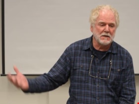
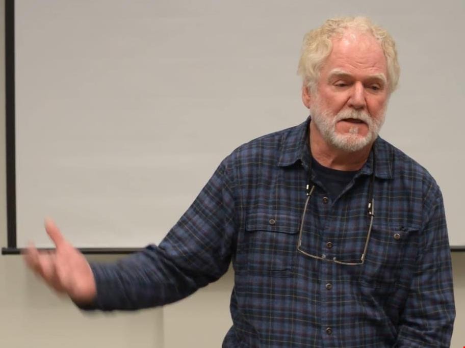
- Video recording of an anecdote shared by Barrie McKenzie, pertaining to Gilmore Avenue School in Burnaby. Barrie attended the school in the 1940s and 1950s. He describes the “punishment paddle” as made by and used on students in the woodworking shop.
- Repository
- Burnaby Village Museum
- Collection/Fonds
- 100 Years of Gilmore School video collection
- Description Level
- Item
- Physical Description
- 1 video recording (mp4) (2 min., 2 sec.) : digital, 23 fps, col., sd., stereo
- Material Details
- Film recorded at the McGill Library on January 17, 2017 as part of an event to screen "100 Years of Gilmore School" by filmmaker Yunuen Perez Vertti.
- Scope and Content
- Video recording of an anecdote shared by Barrie McKenzie, pertaining to Gilmore Avenue School in Burnaby. Barrie attended the school in the 1940s and 1950s. He describes the “punishment paddle” as made by and used on students in the woodworking shop.
- Creator
- Perez Vertti, Yunuen
- Subjects
- Buildings - Schools
- Accession Code
- BV017.48.1
- Access Restriction
- No restrictions
- Reproduction Restriction
- No known restrictions
- Date
- January 17, 2017
- Media Type
- Moving Images
- Historic Neighbourhood
- Vancouver Heights (Historic Neighbourhood)
- Planning Study Area
- Burnaby Heights Area
- Notes
- Title based on contents of film
Images
Video
Film of Barrie McKenzie discussing Gilmore Avenue School, January 17, 2017
Film of Barrie McKenzie discussing Gilmore Avenue School, January 17, 2017
https://search.heritageburnaby.ca/media/hpo/_Data/_BVM_Moving_Images/2017_0048_0001_001.mp4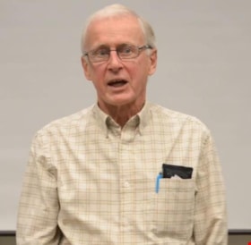
Film of Bruce McRae discussing Gilmore Avenue School
https://search.heritageburnaby.ca/link/museumdescription5118
- Repository
- Burnaby Village Museum
- Date
- January 17, 2017
- Collection/Fonds
- 100 Years of Gilmore School video collection
- Description Level
- Item
- Physical Description
- 1 video recording (mp4) (3 min., 15 sec.) : digital, 23 fps, col., sd., stereo
- Scope and Content
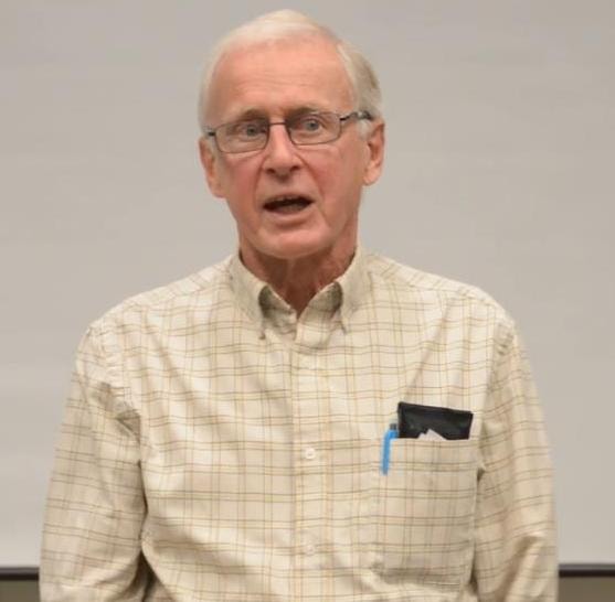
- Recording is of anecdotes shared by Bruce McRae pertaining to Gilmore Avenue School in Burnaby. Bruce recalls that he didn’t attend Gilmore Avenue School, but his mother, Sheila McRae, worked there as an assistant. He describes her work and her enjoyment of it. Bruce also notes that the school had …
- Repository
- Burnaby Village Museum
- Collection/Fonds
- 100 Years of Gilmore School video collection
- Description Level
- Item
- Physical Description
- 1 video recording (mp4) (3 min., 15 sec.) : digital, 23 fps, col., sd., stereo
- Material Details
- Film recorded at the McGill Library on January 17, 2017 as part of an event to screen "100 Years of Gilmore School" by filmmaker Yunuen Perez Vertti.
- Scope and Content
- Recording is of anecdotes shared by Bruce McRae pertaining to Gilmore Avenue School in Burnaby. Bruce recalls that he didn’t attend Gilmore Avenue School, but his mother, Sheila McRae, worked there as an assistant. He describes her work and her enjoyment of it. Bruce also notes that the school had an air raid siren mounted on its roof which sounded terrifying to him when it was tested periodically during the 1950s Cold War era.
- Creator
- Perez Vertti, Yunuen
- Geographic Access
- Gilmore Avenue
- Street Address
- 50 Gilmore Avenue
- Accession Code
- BV017.48.4
- Access Restriction
- No restrictions
- Reproduction Restriction
- No known restrictions
- Date
- January 17, 2017
- Media Type
- Moving Images
- Historic Neighbourhood
- Vancouver Heights (Historic Neighbourhood)
- Planning Study Area
- Burnaby Heights Area
- Notes
- Title based on contents of film
Images
Video
Film of Bruce McRae discussing Gilmore Avenue School, January 17, 2017
Film of Bruce McRae discussing Gilmore Avenue School, January 17, 2017
https://search.heritageburnaby.ca/media/hpo/_Data/_BVM_Moving_Images/2017_0048_0004_001.mp4
Film of Dave Linton discussing Gilmore Avenue School
https://search.heritageburnaby.ca/link/museumdescription5117
- Repository
- Burnaby Village Museum
- Date
- January 17, 2017
- Collection/Fonds
- 100 Years of Gilmore School video collection
- Description Level
- Item
- Physical Description
- 1 video recording (mp4) (51 sec.) : digital, 23 fps, col., sd., stereo
- Scope and Content
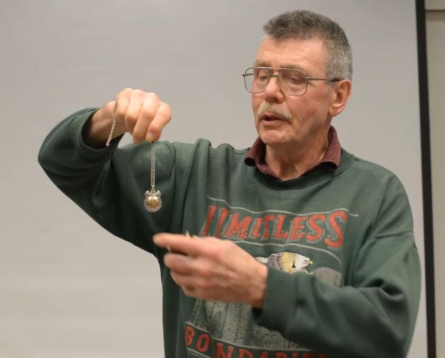
- Recording is an anecdote shared by Dave Linton pertaining to Gilmore Avenue School in Burnaby. Dave displays a medallion which was awarded to his mother by the Burnaby School Board for perfect attendance between the years 1921-1929. Dave attended Gilmore Avenue School, but it is unclear which schoo…
- Repository
- Burnaby Village Museum
- Collection/Fonds
- 100 Years of Gilmore School video collection
- Description Level
- Item
- Physical Description
- 1 video recording (mp4) (51 sec.) : digital, 23 fps, col., sd., stereo
- Material Details
- Film recorded at the McGill Library on January 17, 2017 as part of an event to screen "100 Years of Gilmore School" by filmmaker Yunuen Perez Vertti.
- Scope and Content
- Recording is an anecdote shared by Dave Linton pertaining to Gilmore Avenue School in Burnaby. Dave displays a medallion which was awarded to his mother by the Burnaby School Board for perfect attendance between the years 1921-1929. Dave attended Gilmore Avenue School, but it is unclear which school his mother attended. Asked her name, he replies “Stark”.
- Creator
- Perez Vertti, Yunuen
- Subjects
- Buildings - Schools
- Accession Code
- BV017.48.2
- Access Restriction
- No restrictions
- Reproduction Restriction
- No known restrictions
- Date
- January 17, 2017
- Media Type
- Moving Images
- Historic Neighbourhood
- Vancouver Heights (Historic Neighbourhood)
- Planning Study Area
- Burnaby Heights Area
- Notes
- Title based on contents of film
Images
Video
Film of Dave Linton discussing Gilmore Avenue School, January 17, 2017
Film of Dave Linton discussing Gilmore Avenue School, January 17, 2017
https://search.heritageburnaby.ca/media/hpo/_Data/_BVM_Moving_Images/2017_0048_0002_001.mp4
Film of Julie Lee discussing her family farm in the Big Bend area
https://search.heritageburnaby.ca/link/museumdescription4378
- Repository
- Burnaby Village Museum
- Date
- 6 Oct 2017
- Collection/Fonds
- Burnaby Village Museum fonds
- Description Level
- Item
- Physical Description
- 1 m4v video (13 min., 59 sec.) : digital, 23 fps, col., sd., stereo
- Scope and Content
- Film of Julie Lee discussing her family farm in the Big Bend area of Burnaby during a presentation as part of the "Chinese Canadian Stories" Lecture. This lecture was part of the Burnaby Neighbourhood History Series on October 4, 2017 at the Metrotown branch of the Burnaby Public Library. Julie Lee…
- Repository
- Burnaby Village Museum
- Collection/Fonds
- Burnaby Village Museum fonds
- Description Level
- Item
- Physical Description
- 1 m4v video (13 min., 59 sec.) : digital, 23 fps, col., sd., stereo
- Scope and Content
- Film of Julie Lee discussing her family farm in the Big Bend area of Burnaby during a presentation as part of the "Chinese Canadian Stories" Lecture. This lecture was part of the Burnaby Neighbourhood History Series on October 4, 2017 at the Metrotown branch of the Burnaby Public Library. Julie Lee discusses what life was like growing up on her family farm in the Douglas-Gilpin area, at the corner of Still Creek and Douglas Road in Burnaby.
- History
- Julie Lee is the daughter of Suey Ying Jung (Laura) and Puy Yuen Chan. The couple were married at Fraser Mills in October, 1942. The family owned a farm on Douglas Road near Still Creek in the early 1900s. Their farm was located in front of the Douglas Road interurban tram station.
- Subjects
- Agriculture - Farms
- Accession Code
- BV018.6.1
- Reproduction Restriction
- No known restrictions
- Date
- 6 Oct 2017
- Media Type
- Moving Images
- Historic Neighbourhood
- Burnaby Lake (Historic Neighbourhood)
- Planning Study Area
- Douglas-Gilpin Area
- Notes
- Title based on contents of film
Images

Video
Film of Julie Lee discussing her family farm in the Big Bend area, 6 Oct 2017
Film of Julie Lee discussing her family farm in the Big Bend area, 6 Oct 2017
https://search.heritageburnaby.ca/media/hpo/_Data/_BVM_Moving_Images/2018_0006_0001_001.m4v
Film of Ken Yip discussing his family farm in the Big Bend area
https://search.heritageburnaby.ca/link/museumdescription4379
- Repository
- Burnaby Village Museum
- Date
- 6 Oct 2017
- Collection/Fonds
- Burnaby Village Museum fonds
- Description Level
- Item
- Physical Description
- 1 m4v video (14 min., 57 sec.) : digital, 23 fps, col., sd., stereo
- Scope and Content
- Film of Ken Yip discussing his family farm in the Big Bend area of Burnaby during a presentation as part of the "Chinese Canadian Stories" Lecture. This lecture was part of the Burnaby Neighbourhood History Series on October 4, 2017 at the Metrotown branch of the Burnaby Public Library. Ken Yip dis…
- Repository
- Burnaby Village Museum
- Collection/Fonds
- Burnaby Village Museum fonds
- Description Level
- Item
- Physical Description
- 1 m4v video (14 min., 57 sec.) : digital, 23 fps, col., sd., stereo
- Scope and Content
- Film of Ken Yip discussing his family farm in the Big Bend area of Burnaby during a presentation as part of the "Chinese Canadian Stories" Lecture. This lecture was part of the Burnaby Neighbourhood History Series on October 4, 2017 at the Metrotown branch of the Burnaby Public Library. Ken Yip discusses what life was like growing up on his family farm in the Big Bend area, on Bryne Road in Burnaby.
- Accession Code
- BV018.6.2
- Reproduction Restriction
- No known restrictions
- Date
- 6 Oct 2017
- Media Type
- Moving Images
- Planning Study Area
- Big Bend Area
- Notes
- Title based on contents of film
Images
Video
Film of Ken Yip discussing his family farm in the Big Bend area, 6 Oct 2017
Film of Ken Yip discussing his family farm in the Big Bend area, 6 Oct 2017
https://search.heritageburnaby.ca/media/hpo/_Data/_BVM_Moving_Images/2018_0006_0002_001.m4v
Film of Marcello Agosti discussing Gilmore Avenue School
https://search.heritageburnaby.ca/link/museumdescription5119
- Repository
- Burnaby Village Museum
- Date
- January 17, 2017
- Collection/Fonds
- 100 Years of Gilmore School video collection
- Description Level
- Item
- Physical Description
- 1 video recording (mp4) (2 min., 3 sec.) : digital, 23 fps, col., sd., stereo
- Scope and Content
- Recording is of an anecdote shared by Marcello Agosti pertaining to Gilmore Avenue School in Burnaby. Marcello was a Grade 2 student at the school at the time of the recording. He describes the music class, noting that it has changed greatly since he was in Kindergarten. Marcello talks about the ro…
- Repository
- Burnaby Village Museum
- Collection/Fonds
- 100 Years of Gilmore School video collection
- Description Level
- Item
- Physical Description
- 1 video recording (mp4) (2 min., 3 sec.) : digital, 23 fps, col., sd., stereo
- Material Details
- Film recorded at the McGill Library on January 17, 2017 as part of an event to screen "100 Years of Gilmore School" by filmmaker Yunuen Perez Vertti.
- Scope and Content
- Recording is of an anecdote shared by Marcello Agosti pertaining to Gilmore Avenue School in Burnaby. Marcello was a Grade 2 student at the school at the time of the recording. He describes the music class, noting that it has changed greatly since he was in Kindergarten. Marcello talks about the room, the equipment and resources, the students’ activities, and praises his music teacher.
- Creator
- Perez Vertti, Yunuen
- Subjects
- Buildings - Schools
- Geographic Access
- Gilmore Avenue
- Street Address
- 50 Gilmore Avenue
- Accession Code
- BV017.48.5
- Access Restriction
- No restrictions
- Reproduction Restriction
- May be restricted by third party rights
- Date
- January 17, 2017
- Media Type
- Moving Images
- Historic Neighbourhood
- Vancouver Heights (Historic Neighbourhood)
- Planning Study Area
- Burnaby Heights Area
- Notes
- Title based on contents of film
Images

Video
Film of Marcello Agosti discussing Gilmore Avenue School, January 17, 2017
Film of Marcello Agosti discussing Gilmore Avenue School, January 17, 2017
https://search.heritageburnaby.ca/media/hpo/_Data/_BVM_Moving_Images/2017_0048_0005_001.mp4
Film of Pat Sexsmith discussing Gilmore Avenue School
https://search.heritageburnaby.ca/link/museumdescription5116
- Repository
- Burnaby Village Museum
- Date
- January 17, 2017
- Collection/Fonds
- 100 Years of Gilmore School video collection
- Description Level
- Item
- Physical Description
- 1 video recording (mp4) (2 min., 30 sec.) : digital, 23 fps, col., sd., stereo
- Scope and Content
- Recording is of anecdotes shared by Pat Sexsmith pertaining to Gilmore Avenue School in Burnaby. Pat attended the school in the 1940s and 1950s. She describes recreational activities at the school during a time when resources were few, and recalls the commitment of time made by the school’s teacher…
- Repository
- Burnaby Village Museum
- Collection/Fonds
- 100 Years of Gilmore School video collection
- Description Level
- Item
- Physical Description
- 1 video recording (mp4) (2 min., 30 sec.) : digital, 23 fps, col., sd., stereo
- Material Details
- Film recorded at the McGill Library on January 17, 2017 as part of an event to screen "100 Years of Gilmore School" by filmmaker Yunuen Perez Vertti.
- Scope and Content
- Recording is of anecdotes shared by Pat Sexsmith pertaining to Gilmore Avenue School in Burnaby. Pat attended the school in the 1940s and 1950s. She describes recreational activities at the school during a time when resources were few, and recalls the commitment of time made by the school’s teachers to extracurricular activities for the students.
- Creator
- Perez Vertti, Yunuen
- Subjects
- Buildings - Schools
- Geographic Access
- Gilmore Avenue
- Street Address
- 50 Gilmore Avenue
- Accession Code
- BV017.48.3
- Access Restriction
- No restrictions
- Reproduction Restriction
- No known restrictions
- Date
- January 17, 2017
- Media Type
- Moving Images
- Historic Neighbourhood
- Vancouver Heights (Historic Neighbourhood)
- Planning Study Area
- Burnaby Heights Area
- Notes
- Title based on contents of film
Images
Video
Film of Pat Sexsmith discussing Gilmore Avenue School, January 17, 2017
Film of Pat Sexsmith discussing Gilmore Avenue School, January 17, 2017
https://search.heritageburnaby.ca/media/hpo/_Data/_BVM_Moving_Images/2017_0048_0003_001.mp4
Fire insurance key plan - Greater Vancouver - Volume XIX - Municipality of Burnaby
https://search.heritageburnaby.ca/link/museumdescription17799
- Repository
- Burnaby Village Museum
- Date
- 1927
- Collection/Fonds
- Burnaby Village Museum Map collection
- Description Level
- Item
- Physical Description
- 1 plan on 1 sheet : col. lithographic print ; 64 x 54 cm
- Scope and Content
- Item consists of a one page fire insurance key plan titled "Greater Vancouver / Volume XIX / Municipality / of Burnaby / Key Plan" surveyed May 1927. Key plan from compilation, "Insurance Plans of Greater Vancouver Plan No. 11, Volumes 15 to 19 Burnaby".
- Repository
- Burnaby Village Museum
- Collection/Fonds
- Burnaby Village Museum Map collection
- Description Level
- Item
- Physical Description
- 1 plan on 1 sheet : col. lithographic print ; 64 x 54 cm
- Material Details
- Scale [1:6000]
- Scope and Content
- Item consists of a one page fire insurance key plan titled "Greater Vancouver / Volume XIX / Municipality / of Burnaby / Key Plan" surveyed May 1927. Key plan from compilation, "Insurance Plans of Greater Vancouver Plan No. 11, Volumes 15 to 19 Burnaby".
- Publisher
- Plan Department of Fire Branch of British Columbia Underwriters' Association
- Accession Code
- BV987.1.70
- Access Restriction
- No restrictions
- Reproduction Restriction
- May be restricted by third party rights
- Date
- 1927
- Media Type
- Cartographic Material
- Historic Neighbourhood
- Fraser Arm (Historic Neighbourhood)
- Planning Study Area
- Big Bend Area
- Scan Resolution
- 400
- Scan Date
- 2021-11-17
- Notes
- Title based on contents of item
- Scale 500 feet = 1 inch
- These plans were removed from a bound book with labels on cover page reading: "Plan No. 90 / THIS INSURANCE PLAN / of / Vancouver VOLUME "8" / IN THE PROPERTY OF THE / British Columbia Insurance Underwriter's Association / Vancouver B.C. / AND IS LOANED / MELVILLE F. THOMSON CO. .../ Date May 26th, 1934"; / "Plan No. 74 / THIS INSURANCE PLAN / OF / VANCOUVER VOLUME "9"" / Plan No. 11 / THIS INSURANCE PLAN / OF / BURNABY VOLUMES 15-19" / "THIS PLAN IS THE PROPERTY OF / THE / BRITISH LAW INSURANCE COMPANY / LIMITED"
- Does not include the corresponding key plan page or associated plans numbered 1901 to 1914
- Contact Burnaby Village Museum to view associated fire insurance plans
Zoomable Images

Fire insurance key plan - Greater Vancouver - Volume XIX - Municipality of Burnaby, 1927
Zoom into Image
Fire insurance key plan - Greater Vancouver - Volume XVI - Municipality of Burnaby
https://search.heritageburnaby.ca/link/museumdescription17796
- Repository
- Burnaby Village Museum
- Date
- 1927
- Collection/Fonds
- Burnaby Village Museum Map collection
- Description Level
- Item
- Physical Description
- 2 plans on 2 sheets: col. lithographic print ; 64 x 54 cm
- Scope and Content
- Item consists of a two page fire insurance key plan titled "Greater Vancouver / Volume XVI / Municipality / of Burnaby / Key Plan" surveyed May 1927. Volume XVI includes a two page Key Plan (C and D). .
- Repository
- Burnaby Village Museum
- Collection/Fonds
- Burnaby Village Museum Map collection
- Description Level
- Item
- Physical Description
- 2 plans on 2 sheets: col. lithographic print ; 64 x 54 cm
- Scope and Content
- Item consists of a two page fire insurance key plan titled "Greater Vancouver / Volume XVI / Municipality / of Burnaby / Key Plan" surveyed May 1927. Volume XVI includes a two page Key Plan (C and D). .
- Publisher
- Plan Department of Fire Branch of British Columbia Underwriters Association
- Accession Code
- BV987.1.70
- Access Restriction
- No restrictions
- Reproduction Restriction
- May be restricted by third party rights
- Date
- 1927
- Media Type
- Cartographic Material
- Scan Resolution
- 400
- Scan Date
- 11/17/2021
- Notes
- Title based on contents of item
- Item "GREATER VANCOUVER / VOLUME XVI / MUNICIPALITY OF / BURNABY / KEY PLAN" does not include associated numbered plans (1601 to 1651)
- These plans were removed from a bound book with labels on cover page reading: "Plan No. 90 / THIS INSURANCE PLAN / of / Vancouver VOLUME "8" / IN THE PROPERTY OF THE / British Columbia Insurance Underwriter's Association / Vancouver B.C. / AND IS LOANED / MELVILLE F. THOMSON CO. .../ Date May 26th, 1934"; / "Plan No. 74 / THIS INSURANCE PLAN / OF / VANCOUVER VOLUME "9"" / Plan No. 11 / THIS INSURANCE PLAN / OF / BURNABY VOLUMES 15-19" / "THIS PLAN IS THE PROPERTY OF / THE / BRITISH LAW INSURANCE COMPANY / LIMITED"
Zoomable Images

Fire insurance key plan - Greater Vancouver - Volume XVI - Municipality of Burnaby, 1927
Zoom into Image

From Fuki to Ofuro: Japanese Canadians in Burnaby
https://search.heritageburnaby.ca/link/museumdescription17535
- Repository
- Burnaby Village Museum
- Date
- 7 Oct. 2021
- Collection/Fonds
- Burnaby Village Museum fonds
- Description Level
- Item
- Physical Description
- 1 video recording (mp4) (84 min., 20 sec.) : digital, col., sd., stereo ; 29 fps
- Scope and Content
- Item consists of a video recording of a live Zoom webinar on the Burnaby Village Museum Facebook page on October 7, 2021. The webinar was hosted by Burnaby Village Museum Community Engagement Coordinator, Christina Froschauer and presented by Raymond Nakamura. The webinar is titled "From Fuki to O…
- Repository
- Burnaby Village Museum
- Collection/Fonds
- Burnaby Village Museum fonds
- Description Level
- Item
- Physical Description
- 1 video recording (mp4) (84 min., 20 sec.) : digital, col., sd., stereo ; 29 fps
- Material Details
- Presenter: Raymond Nakamura
- Host: Christina Froschauer
- Date of Presentation: October 7, 2021
- Total Number of tracks: 1
- Total Length of all tracks: 84 min., 20 sec.
- Recording Device: Zoom video communication and Facebook platforms
- Recording Note: Film was edited from it's original recorded version (97 min., 37 sec.) to edited version (84 min., 20 sec.) for public viewing on Heritage Burnaby.
- Scope and Content
- Item consists of a video recording of a live Zoom webinar on the Burnaby Village Museum Facebook page on October 7, 2021. The webinar was hosted by Burnaby Village Museum Community Engagement Coordinator, Christina Froschauer and presented by Raymond Nakamura. The webinar is titled "From Fuki to Ofuro: Japanese Canadians in Burnaby". In this webinar, Raymond Nakamura shares his own Japanese family history (Yamashita and Nakamura families) in British Columbia; provides insight into the Fuki plant (also known as butterbur) which was used by Japanese Canadians as a special culinary plant; describes the customs behind the ofuro (Japanese bathhouse) at Burnaby Village Museum and shares some of his research on Japanese Canadians who lived in Burnaby prior to the internment of Japanese Canadians in World War II. The title slide of Raymond's presentation reads "Japanese Canadians in Pre-War Burnaby". Raymond's presentation is supported with his own illustrations along with historical photographs from personal and public archival collections including the Nikkei National Museum, The City of Burnaby Archives and the Burnaby Village Museum. Japanese families highlighted in Raymond's talk include the Nakamuras; Yamashitas; Yasuis; Kokuryos; Kojimas; Shimotakaharas; Kariatsumaris; Ibatas; Marie Karamoto family and Dr. Taihei Kuzuhara. Many historical references regarding Burnaby residents come from Burnaby publications; "In the Shadow by the Sea : recollections of Burnaby's Barnet Village" and "Pioneer Tales of Burnaby". During breaks in the presentation, Christina and Raymond take questions from webinar participants on zoom as well as viewers from the live recording on Burnaby Village Museum's Facebook page. Resource links shared during presentation include: Nikkei National Museum & Cultural Centre https://centre.nikkeiplace.org/res.../search-the-collection/ Landscapes of Injustic Archive https://loi.uvic.ca/archive/ Raymond's Brain https://www.raymondsbrain.com/ In the Shadow by the Sea : recollections of Burnaby's Barnet Village https://search.heritageburnaby.ca/permalink/museumlibrary5173
- History
- Raymond Nakamura was born and raised in Toronto, and has lived most of his adult life in Vancouver. Holding a PhD in Marine Sciences from University of Toronto, Raymond’s study specializing in the hydrodynamics of sand dollars. More recently, he has been recognized for his research work on Japanese Canadians, leading to fact and fiction writing, co-hosting podcasts and delivering creative presentations on the subject –one of which we are honoured to see today. Raymond has worked collaboratively with cultural centers across the Greater Vancouver Region, including Science World, the Vancouver Aquarium, the Nikkei National Museum, the Gulf of Georgia Cannery, to name a few.
- Names
- Shimotakahara, Hideko
- Yasui, Harding
- Yasui, Sukegoro
- Kokuryo, Hideko
- Karamoto, Marie
- Nakamura, Raymond
- Yamashita family
- Kuzuhara, Dr. Taihei
- Froschauer , Christina
- Burnaby Village Museum
- Kojima family
- Accession Code
- BV021.31.1
- Access Restriction
- No restrictions
- Reproduction Restriction
- No known restrictions
- Date
- 7 Oct. 2021
- Media Type
- Moving Images
- Notes
- Title based on contents of video recording
Images

Video
From Fuki to Ofuro: Japanese Canadians in Burnaby, 7 Oct. 2021
From Fuki to Ofuro: Japanese Canadians in Burnaby, 7 Oct. 2021
https://search.heritageburnaby.ca/media/hpo/_Data/_BVM_Moving_Images/2021_0031_0001_003.mp4![Galiano Island, Oak Theatre and Calgary, [between 1939 and 1941] thumbnail](/media/Hpo/_Data/_Archives_Moving_Images/_Unrestricted/562-003-7.jpg?width=280)
Galiano Island, Oak Theatre and Calgary
https://search.heritageburnaby.ca/link/archivedescription85241
- Repository
- City of Burnaby Archives
- Date
- [between 1939 and 1941]
- Collection/Fonds
- Digney Family fonds
- Description Level
- Item
- Physical Description
- 1 film clip (9 min., 51 sec.) : digital, col., si.
- Scope and Content
- Item is a silent digitized colour film segment identified as Reel 7. The film segment opens with footage of the shores of Galiano Island and soon switches to a game of table tennis and a boat ride up Burrard Inlet with Grannie Swan and company. The boat ride continues to the marina at Horseshoe Bay…
- Repository
- City of Burnaby Archives
- Date
- [between 1939 and 1941]
- Collection/Fonds
- Digney Family fonds
- Physical Description
- 1 film clip (9 min., 51 sec.) : digital, col., si.
- Description Level
- Item
- Record No.
- 562-003-7
- Access Restriction
- No restrictions
- Reproduction Restriction
- May be restricted by third party rights
- Accession Number
- 2014-04
- Scope and Content
- Item is a silent digitized colour film segment identified as Reel 7. The film segment opens with footage of the shores of Galiano Island and soon switches to a game of table tennis and a boat ride up Burrard Inlet with Grannie Swan and company. The boat ride continues to the marina at Horseshoe Bay where the family goes ashore. This footage is followed with a dark segment of footage of a paegant at the Oak Theatre in 1941 and the gardens of the Oak Theatre. The film has a break and continues with footage of the Digney family travels to the Calgary Breweries, Calgary Zoo, and the Calgary Stampede parade and fairgrounds, Alberta, closing with footage of the Rockies and Rogers Pass.
- Subjects
- Animals - Birds
- Events - Parades
- Media Type
- Moving Images
- Photographer
- Digney, Andy
- Creator
- Digney, Andy
- Notes
- Title based on contents of film
- Geographic Access
- Burrard Inlet
- Historic Neighbourhood
- Central Park (Historic Neighbourhood)
- Planning Study Area
- Kingsway-Beresford Area
Images
![Galiano Island, Oak Theatre and Calgary, [between 1939 and 1941] thumbnail](/media/Hpo/_Data/_Archives_Moving_Images/_Unrestricted/562-003-7.jpg)
Video
Galiano Island, Oak Theatre and Calgary, [between 1939 and 1941]
Galiano Island, Oak Theatre and Calgary, [between 1939 and 1941]
https://search.heritageburnaby.ca/media/hpo/_Data/_Archives_Moving_Images/_Unrestricted/562-003-7.m4v
Gilmour Avenue School site
https://search.heritageburnaby.ca/link/museumdescription11129
- Repository
- Burnaby Village Museum
- Date
- May 27, 1915
- Collection/Fonds
- Ronald G. Scobbie collection
- Description Level
- Item
- Physical Description
- 1 survey plan : blueprint on paper ; 56 x 54 cm
- Scope and Content
- Survey plan of Gilmore Avenue School site. Title on plan reads: "Gilmour Avenue School Site / Burnaby Municipality / Being Lots 1-10 inc. & Lots 27-36 inc. of Block 9 / of Subdivision of a Portion of Lot 187, GP.1 / New Westminster District". "Note. School site is as shown below, the original...am…
- Repository
- Burnaby Village Museum
- Collection/Fonds
- Ronald G. Scobbie collection
- Description Level
- Item
- Physical Description
- 1 survey plan : blueprint on paper ; 56 x 54 cm
- Material Details
- Scale: 40 feet = 1 inch
- Scope and Content
- Survey plan of Gilmore Avenue School site. Title on plan reads: "Gilmour Avenue School Site / Burnaby Municipality / Being Lots 1-10 inc. & Lots 27-36 inc. of Block 9 / of Subdivision of a Portion of Lot 187, GP.1 / New Westminster District". "Note. School site is as shown below, the original...amended" "by cancelling Lots 1-10 & 27-30 inc....order of court filed No.4938".
- History
- The school was named after Hugh B. Gilmour, but an error by a municipal clerk in the Street Naming Bylaw in 1912 (Bylaw Number 135) changed the spelling to "Gilmore" Avenue and the school name was spelled "Gilmore" Avenue School hereafter.
- Creator
- McGugan, Donald Johnston
- Subjects
- Buildings - Schools
- Names
- Gilmore Avenue School
- Responsibility
- Burnett & McGugan, Engineers and Surveyors
- Geographic Access
- Gilmore Avenue
- Accession Code
- BV003.83.8
- Access Restriction
- No restrictions
- Reproduction Restriction
- No known restrictions
- Date
- May 27, 1915
- Media Type
- Cartographic Material
- Historic Neighbourhood
- Vancouver Heights (Historic Neighbourhood)
- Planning Study Area
- Willingdon Heights Area
- Scan Resolution
- 440
- Scan Date
- 22-Dec-2020
- Scale
- 100
- Notes
- Transcribed title taken from plan
- Oath in bottom left corner reads: "I, D.J. McGugan...did superintend the survey", "...completed on the 27th day of May 1915" and noterized by Walter Edmonds" "sworn...29th Day of May 1915"; "Burnett and McGugan. B.C. Land Surveyors Etc. New Westminster. B.C."
- Note in black ink on verso of plan reads: "1782"
Zoomable Images

![Give Art a Home campaign, [1992] thumbnail](/media/Hpo/_Data/_Archives_Moving_Images/_Unrestricted/599-001.jpg?width=280)
Give Art a Home campaign
https://search.heritageburnaby.ca/link/archivedescription64770
- Repository
- City of Burnaby Archives
- Date
- [1992]
- Collection/Fonds
- Burnaby Historical Society fonds
- Description Level
- Item
- Physical Description
- 1 file of textual records + 1 videocassette (7 min.)
- Scope and Content
- File consists of records pertaining to the Burnaby Arts Centre for their Capital Campaign entitled, "Give Art a Home" including a seven minute Video Home System (VHS) tape and correspondence. Also included in the file is a box of "Mr. Dressup" crayons.
- Repository
- City of Burnaby Archives
- Date
- [1992]
- Collection/Fonds
- Burnaby Historical Society fonds
- Subseries
- Municipal record subseries
- Physical Description
- 1 file of textual records + 1 videocassette (7 min.)
- Description Level
- Item
- Record No.
- MSS133-001
- 599-001
- Access Restriction
- No restrictions
- Reproduction Restriction
- May be restricted by third party rights
- Accession Number
- BHS2001-14
- Scope and Content
- File consists of records pertaining to the Burnaby Arts Centre for their Capital Campaign entitled, "Give Art a Home" including a seven minute Video Home System (VHS) tape and correspondence. Also included in the file is a box of "Mr. Dressup" crayons.
- Media Type
- Moving Images
- Notes
- Image used in the campaign is by Joe Average
Images
![Give Art a Home campaign, [1992] thumbnail](/media/Hpo/_Data/_Archives_Moving_Images/_Unrestricted/599-001.jpg)
Video
Give Art a Home campaign, [1992]
Give Art a Home campaign, [1992]
https://search.heritageburnaby.ca/media/Hpo/_Data/_Archives_Moving_Images/_Unrestricted/599-001.mp4
Hawaii
https://search.heritageburnaby.ca/link/archivedescription85436
- Repository
- City of Burnaby Archives
- Date
- 1970
- Collection/Fonds
- George H.F. McLean fonds
- Description Level
- Item
- Physical Description
- 1 digital file ( 4 min., 30 sec ) : digital , col., si.
- Scope and Content
- Item consists of one silent colour film of Edna and George McLean's visit to Hawaii. The film opens with blurry footage of Hawiian hula dancers and switches to aerial views of the Hawaiian islands, the oceanside and coastal views. The film closes with Edna McLean exiting an airplane and views of p…
- Repository
- City of Burnaby Archives
- Date
- 1970
- Collection/Fonds
- George H.F. McLean fonds
- Physical Description
- 1 digital file ( 4 min., 30 sec ) : digital , col., si.
- Description Level
- Item
- Record No.
- 567-001-21
- Access Restriction
- No restrictions
- Reproduction Restriction
- May be restricted by third party rights
- Accession Number
- 2014-03
- Scope and Content
- Item consists of one silent colour film of Edna and George McLean's visit to Hawaii. The film opens with blurry footage of Hawiian hula dancers and switches to aerial views of the Hawaiian islands, the oceanside and coastal views. The film closes with Edna McLean exiting an airplane and views of palm trees.
- Media Type
- Moving Images
- Photographer
- McLean, George H.F.
- Notes
- Title based on content of film
- Films originated in an 8mm format and were digitized by George McLean before being donated to the CBA
Images
Video
Hawaii, 1970
Hickory Dickory Dock-What is the time on the clock?
https://search.heritageburnaby.ca/link/museumdescription9679
- Repository
- Burnaby Village Museum
- Date
- 2016
- Collection/Fonds
- Burnaby Village Museum Film and Video collection
- Description Level
- Item
- Physical Description
- 1 video recording (mp4) (14 min., 47 sec.) : digital, 25 fps, col., sd., stereo
- Scope and Content
- In this short film, Yasmin Jamal declares her passion for clocks and fancy watches, but confesses that she has a troubled relationship with them! From her kitchen clock that does not tell the correct time, to her collection of beautiful wrist watches that refuse to do their job, she is beginning to…
- Repository
- Burnaby Village Museum
- Collection/Fonds
- Burnaby Village Museum Film and Video collection
- Description Level
- Item
- Physical Description
- 1 video recording (mp4) (14 min., 47 sec.) : digital, 25 fps, col., sd., stereo
- Scope and Content
- In this short film, Yasmin Jamal declares her passion for clocks and fancy watches, but confesses that she has a troubled relationship with them! From her kitchen clock that does not tell the correct time, to her collection of beautiful wrist watches that refuse to do their job, she is beginning to question this strange relationship. Why does she hold such a love and passion for time pieces that are too stubborn to keep time? She is aware that her attraction to timepieces is about more than needing to know the time. Her touching mediation on the reasons for her attachment reminds her audience that time is a treasure and we should make the most of every moment.
- History
- Yasmin Jamal immigrated from Kenya over 44 years ago. She came to pursue her undergraduate degree at Simon Fraser University. She is a long-time resident of Coquitlam. However, she has always been employed in the Burnaby District. She presently works as a librarian at Burnaby Public Library. Prior to that, she was employed at Simon Fraser University, Burnaby campus. She loves Canada, but still treasures the fond memories of her childhood in Kenya. Yasmin visits Kenya every 8-10 years to feel the warm waters & white sands of the tropical beaches.
- Creator
- Jamal, Yasmin B.
- Other Title Information
- title supplied by film maker
- Subjects
- Timekeeping Tools and Equipment
- Names
- Jamal, Yasmin B.
- Accession Code
- BV016.37.10
- Access Restriction
- No restrictions
- Reproduction Restriction
- May be restricted by third party rights
- Date
- 2016
- Media Type
- Moving Images
- Notes
- Transcribed title
Images
Video
Hickory Dickory Dock-What is the time on the clock?, 2016
Hickory Dickory Dock-What is the time on the clock?, 2016
https://search.heritageburnaby.ca/media/hpo/_Data/_BVM_Moving_Images/2016_0037_0010_001.mp4![Highways map of British Columbia, Alberta and adjacent states, [1930] thumbnail](/media/hpo/_Data/_BVM_Cartographic_Material/1977/1977_0037_0187_001.jpg?width=280)
Highways map of British Columbia, Alberta and adjacent states
https://search.heritageburnaby.ca/link/museumdescription9668
- Repository
- Burnaby Village Museum
- Date
- [1930]
- Collection/Fonds
- Burnaby Village Museum Map collection
- Description Level
- Item
- Physical Description
- 1 map : col. lithographic print ; both sides ; 89.5 x 58 cm, folded to 11.5 x 20 cm
- Scope and Content
- Double sided road map published by Imperial Oil, Ltd. and featuring the main travelled highway routes of British Columbia, Alberta and the Northwestern-most states of the United States of America. The map is a colour lithograph. The main map is green, with the highways highlighted in red. The litho…
- Repository
- Burnaby Village Museum
- Collection/Fonds
- Burnaby Village Museum Map collection
- Description Level
- Item
- Physical Description
- 1 map : col. lithographic print ; both sides ; 89.5 x 58 cm, folded to 11.5 x 20 cm
- Material Details
- Scale 1 inch = 20 miles
- A.R. THOMSON / CHIEF CARTOGRAPHER
- Scope and Content
- Double sided road map published by Imperial Oil, Ltd. and featuring the main travelled highway routes of British Columbia, Alberta and the Northwestern-most states of the United States of America. The map is a colour lithograph. The main map is green, with the highways highlighted in red. The lithograph was created in Canada by Rolph Clark Stone Ltd in Toronto. The opposite side of the map features inset maps of the following: the Trans-Canada Highway, the highway between Prince Rupert and Prince George, the highway through the Canadian Rockies, and the highway through the Peace River District. Small city plan maps of highways through major cities, as well as advertisements for Imperial Oil products, are also found on the opposite side of the main map. This map is one of four produced by Imperial Oil that covered the most populated areas of Canada from coast to coast and paralleled Imperial Oil's distribution service.
- Creator
- Thomson, A.R.
- Publisher
- Imperial Oil Limited
- Accession Code
- HV977.37.187
- Access Restriction
- No restrictions
- Reproduction Restriction
- No known restrictions
- Date
- [1930]
- Media Type
- Cartographic Material
- Scan Resolution
- 600
- Scan Date
- 2023-11-10
- Notes
- Title based on content of map
Zoomable Images
![Highways map of British Columbia, Alberta and adjacent states, [1930] thumbnail](/media/hpo/_Data/_BVM_Cartographic_Material/1977/1977_0037_0187_003_seadragon/1977_0037_0187_003.jpg?w=280)


Howard Avenue School site
https://search.heritageburnaby.ca/link/museumdescription11124
- Repository
- Burnaby Village Museum
- Date
- March 24, 1915
- Collection/Fonds
- Ronald G. Scobbie collection
- Description Level
- Item
- Physical Description
- 1 survey plan : blueprint on paper ; 56 x 54 cm
- Scope and Content
- Survey plan of "Howard Avenue School Site" "Burnaby Municipality", "Being Lots 1-5 and 14-18 Inc. Block 5 of the Subd. of Easterly 3/4 of Lot 127. Group 1, New Westminster District";
- Repository
- Burnaby Village Museum
- Collection/Fonds
- Ronald G. Scobbie collection
- Description Level
- Item
- Physical Description
- 1 survey plan : blueprint on paper ; 56 x 54 cm
- Material Details
- Scale: 40 feet = 1 inch
- Scope and Content
- Survey plan of "Howard Avenue School Site" "Burnaby Municipality", "Being Lots 1-5 and 14-18 Inc. Block 5 of the Subd. of Easterly 3/4 of Lot 127. Group 1, New Westminster District";
- Creator
- McGugan, Donald Johnston
- Subjects
- Buildings - Schools
- Names
- Howard Avenue School
- Responsibility
- Burnett and McGugan B.C. Land Surveyors, New Westminster
- Geographic Access
- Howard Avenue
- Georgia Street
- Accession Code
- BV003.83.4
- Access Restriction
- No restrictions
- Reproduction Restriction
- No known restrictions
- Date
- March 24, 1915
- Media Type
- Cartographic Material
- Historic Neighbourhood
- Capitol Hill (Historic Neighbourhood)
- Planning Study Area
- Capitol Hill Area
- Scan Resolution
- 440
- Scan Date
- 22-Dec-2020
- Scale
- 100
- Notes
- Title based on contents of plan
- Oath in bottom left corner reads: "I, D.J. McGugan...and did personally superintend the survey..." "...completed on the 24th day of March 1915"; signed "D.J. McGugan", notarized on April 12th, 1915 by "R. Chapman"
- handwritten on back, "1754"
Zoomable Images

![Indexed guide map of the City of Vancouver and suburbs, [1920] thumbnail](/media/hpo/_Data/_BVM_Cartographic_Material/1975/1975_0061_0013_001.jpg?width=280)
Indexed guide map of the City of Vancouver and suburbs
https://search.heritageburnaby.ca/link/museumdescription8678
- Repository
- Burnaby Village Museum
- Date
- [1920]
- Collection/Fonds
- Burnaby Village Museum Map collection
- Description Level
- Item
- Physical Description
- 1 map + textual record : col. lithographic print on paper ; 51.5 x 71 cm folded to 21 x 10 cm
- Scope and Content
- Item consists of a fold out map entitled "Indexed Guide Map of Vancouver and Suburbs" with index. Map includes concentric circles raditating out from Vancouver City Hall on corner of Hastings Street and Main Street; electric railways are indicated by heavy red lines in centres of streets. Includes …
- Repository
- Burnaby Village Museum
- Collection/Fonds
- Burnaby Village Museum Map collection
- Description Level
- Item
- Physical Description
- 1 map + textual record : col. lithographic print on paper ; 51.5 x 71 cm folded to 21 x 10 cm
- Material Details
- Scale [1:47520]
- Index on 4 pages within cardstock cover with advertisements on verso
- Scope and Content
- Item consists of a fold out map entitled "Indexed Guide Map of Vancouver and Suburbs" with index. Map includes concentric circles raditating out from Vancouver City Hall on corner of Hastings Street and Main Street; electric railways are indicated by heavy red lines in centres of streets. Includes old and new street names. Index includes a District Lot Index and Street Index.
- Publisher
- Vancouver Map and Blue Print Company
- Accession Code
- HV975.61.13
- Access Restriction
- No restrictions
- Reproduction Restriction
- No known restrictions
- Date
- [1920]
- Media Type
- Cartographic Material
- Textual Record
- Publisher Series
- 6th edition revised June 1920
- Scan Resolution
- 600
- Scan Date
- 2023-11-10
- Notes
- Title based on contents of map
- Cover of booklet reads: "INDEXED / Guide Map / of the CITY of / VANCOUVER / and / SUBURBS / Compiled and Published by / The Vancouver Map & Blue Print Co. / ...."INTERNATIONAL / BOOK SHOP / Cor. Columbia and Hastings Sts._Vancouver, B.C.".
Documents
Zoomable Images
![Indexed guide map of the City of Vancouver and suburbs, [1920] thumbnail](/media/hpo/_Data/_BVM_Cartographic_Material/1975/1975_0061_0013_002_seadragon/1975_0061_0013_002.jpg?w=280)

Indexed guide map of the city of Vancouver and Suburbs
https://search.heritageburnaby.ca/link/museumdescription8694
- Repository
- Burnaby Village Museum
- Date
- 1914
- Collection/Fonds
- Burnaby Village Museum Map collection
- Description Level
- Item
- Physical Description
- 1 map + textual record : col. lithographic print on paper ; 55 x 78 cm on sheet 58.5 x 82 cm folded to 20 x 10 cm
- Scope and Content
- Item consists of a map "Indexed Guide Map of the City of Vancouver and Suburbs compiled and published by The Vancouver Map and Blueprint Co. Ltd. Map shows district lots, blocks and boundaries between City of Vancouver, Point Grey, South Vancouver, Burnaby, New Westminster and parts of Richmond, No…
- Repository
- Burnaby Village Museum
- Collection/Fonds
- Burnaby Village Museum Map collection
- Description Level
- Item
- Physical Description
- 1 map + textual record : col. lithographic print on paper ; 55 x 78 cm on sheet 58.5 x 82 cm folded to 20 x 10 cm
- Material Details
- Scale not defined
- Map is folded into booklet form
- Scope and Content
- Item consists of a map "Indexed Guide Map of the City of Vancouver and Suburbs compiled and published by The Vancouver Map and Blueprint Co. Ltd. Map shows district lots, blocks and boundaries between City of Vancouver, Point Grey, South Vancouver, Burnaby, New Westminster and parts of Richmond, North Vancouver and West Vancouver. Concentric cirlces indicate the distance in miles from the intersection of Main Street and Hastings Street, Vancouver in intervals of 1/2 mile. Map is folded into booklet form and includes a four page index with cardstock cover. Index page 1 is titled "Hotels"; page 2 is titled "District Lot Index"; pages 3-8 "Street Index".
- Publisher
- Vancouver Map and Blueprint Company Limited
- Edition
- 5th Edition revised to June 1914
- Geographic Access
- Vancouver
- Accession Code
- HV983.9.18
- Date
- 1914
- Media Type
- Cartographic Material
- Scan Resolution
- 600
- Scan Date
- 2023-08-17
- Notes
- Transcribed title from map and cover
- Sticker adhered to front cover of index of two lions "Service / "WE GIVE IT" / WESTERN SPECIALTY / LIMITED/ STATIONERS AND PRINTERS / VANCOUVER - B.C."
Documents
Zoomable Images

![Indexed map of Greater Vancouver, [193-] thumbnail](/media/hpo/_Data/_BVM_Cartographic_Material/1976/1976_0026_0001_001.jpg?width=280)
Indexed map of Greater Vancouver
https://search.heritageburnaby.ca/link/museumdescription8201
- Repository
- Burnaby Village Museum
- Date
- [193-]
- Collection/Fonds
- Burnaby Village Museum Map collection
- Description Level
- Item
- Physical Description
- 1 map + 1 p. textual records : b&w lithographic print on 1 sheet ; 46 x 41 cm folded to 23 x 10 cm
- Scope and Content
- Item consists of a promotional brochure for Bekins Moving and Storage, with an indexed map of Greater Vancouver showing distances from the Bekins building located at Pender Street and Beatty Street on one side, and text and images advertising the company's services and facilities on the other side.…
- Repository
- Burnaby Village Museum
- Collection/Fonds
- Burnaby Village Museum Map collection
- Description Level
- Item
- Physical Description
- 1 map + 1 p. textual records : b&w lithographic print on 1 sheet ; 46 x 41 cm folded to 23 x 10 cm
- Material Details
- Scale not defined
- Printing on two sides of sheet
- Folded into eight sections
- Scope and Content
- Item consists of a promotional brochure for Bekins Moving and Storage, with an indexed map of Greater Vancouver showing distances from the Bekins building located at Pender Street and Beatty Street on one side, and text and images advertising the company's services and facilities on the other side. Cover of folded map reads "Indexed Map of Greater Vancouver / The Great Northwest for Opportunity / Compliments of / Bekins Moving and / Storage Co.".
- Responsibility
- Bekins Moving and Storage Company Limited
- Accession Code
- HV976.26.1
- Access Restriction
- No restrictions
- Reproduction Restriction
- No known restrictions
- Date
- [193-]
- Media Type
- Cartographic Material
- Textual Record
- Scan Resolution
- 600
- Scan Date
- 2023-08-17
- Notes
- Title based on contents of map
![Indexed map of Greater Vancouver, [193-] thumbnail](/media/hpo/_Data/_BVM_Cartographic_Material/1976/1976_0026_0001_001_seadragon/1976_0026_0001_001.jpg?w=280)