More like 'E.W. Bateman House 'Elworth''
Narrow Results By
Subject
- Advertising Medium - Signs and Signboards 17
- Buildings - Civic - Hospitals 6
- Buildings - Civic - Libraries 1
- Buildings - Commercial 5
- Buildings - Commercial - Drugstores 1
- Buildings - Commercial - Grocery Stores 12
- Buildings - Commercial - Malls 2
- Buildings - Commercial - Offices 1
- Buildings - Commercial - Restaurants 4
- Buildings - Commercial - Service Stations 1
- Buildings - Commercial - Stores 3
- Buildings - Heritage 1

7530 Buller Avenue
https://search.heritageburnaby.ca/link/archivedescription98686
- Repository
- City of Burnaby Archives
- Date
- 2022
- Collection/Fonds
- Disappearing Burnaby collection
- Description Level
- Item
- Physical Description
- 1 photograph (jpeg) : col.
- Scope and Content
- Photograph of the exterior of a two-storey house located at 7530 Buller Avenue. The photograph depicts the house at dusk; the house stands behind a wooden fence and is surrounded by trees. The house was constructed in 1924 and was formerly known as "Ryverbrae," the William & Esther Burdick Residenc…
- Repository
- City of Burnaby Archives
- Date
- 2022
- Collection/Fonds
- Disappearing Burnaby collection
- Physical Description
- 1 photograph (jpeg) : col.
- Description Level
- Item
- Record No.
- 634-033
- Access Restriction
- No restrictions
- Reproduction Restriction
- No restrictions
- Accession Number
- 2022-14
- Scope and Content
- Photograph of the exterior of a two-storey house located at 7530 Buller Avenue. The photograph depicts the house at dusk; the house stands behind a wooden fence and is surrounded by trees. The house was constructed in 1924 and was formerly known as "Ryverbrae," the William & Esther Burdick Residence.
- Media Type
- Photograph
- Photographer
- Cheung, Nakita
- Notes
- Title taken from the associated blog post
- Associated blog post: https://disappearingburnaby.wordpress.com/2022/06/30/william-esther-burdick-residence/
- Geographic Access
- Buller Avenue
- Street Address
- 7530 Buller Avenue
- Historic Neighbourhood
- Alta Vista (Historic Neighbourhood)
- Planning Study Area
- Clinton-Glenwood Area
Images


3955 Moscrop Street
https://search.heritageburnaby.ca/link/archivedescription98654
- Repository
- City of Burnaby Archives
- Date
- 2021
- Collection/Fonds
- Disappearing Burnaby collection
- Description Level
- Item
- Physical Description
- 1 photograph (jpeg) : col.
- Scope and Content
- Photograph of the exterior of a house located at 3955 Moscrop Street. The house was constructed in 1954. The photograph depicts the house at night, with the house's porch light on, and a car is in the driveway in front of the house.
- Repository
- City of Burnaby Archives
- Date
- 2021
- Collection/Fonds
- Disappearing Burnaby collection
- Physical Description
- 1 photograph (jpeg) : col.
- Description Level
- Item
- Record No.
- 634-001
- Access Restriction
- No restrictions
- Reproduction Restriction
- No restrictions
- Accession Number
- 2022-14
- Scope and Content
- Photograph of the exterior of a house located at 3955 Moscrop Street. The house was constructed in 1954. The photograph depicts the house at night, with the house's porch light on, and a car is in the driveway in front of the house.
- Media Type
- Photograph
- Photographer
- Cheung, Nakita
- Notes
- Title taken from the associated blog post
- Associated blog post: https://disappearingburnaby.wordpress.com/2022/02/24/moscrop-house/
- Geographic Access
- Moscrop Street
- Street Address
- 3955 Moscrop Street
- Historic Neighbourhood
- Broadview (Historic Neighbourhood)
- Planning Study Area
- Cascade-Schou Area
Images


5990 Irmin Street
https://search.heritageburnaby.ca/link/archivedescription98685
- Repository
- City of Burnaby Archives
- Date
- 2022
- Collection/Fonds
- Disappearing Burnaby collection
- Description Level
- Item
- Physical Description
- 1 photograph (jpeg) : col.
- Scope and Content
- Photograph of a multi-storey house located at 5990 Irmin Street. The photograph depicts of the exterior of the house at dusk; a light is on in one of the house's rooms and a vehicle is parked in the house's driveway next to a portable garage. A "For Sale" sign on the edge of the property reads: "Fu…
- Repository
- City of Burnaby Archives
- Date
- 2022
- Collection/Fonds
- Disappearing Burnaby collection
- Physical Description
- 1 photograph (jpeg) : col.
- Description Level
- Item
- Record No.
- 634-032
- Access Restriction
- No restrictions
- Reproduction Restriction
- No restrictions
- Accession Number
- 2022-14
- Scope and Content
- Photograph of a multi-storey house located at 5990 Irmin Street. The photograph depicts of the exterior of the house at dusk; a light is on in one of the house's rooms and a vehicle is parked in the house's driveway next to a portable garage. A "For Sale" sign on the edge of the property reads: "Future Development Land." Another house is visible in the background. The house was constructed in 1923 and is nearby to 7530 Buller Avenue.
- Media Type
- Photograph
- Photographer
- Cheung, Nakita
- Notes
- Title taken from the associated blog post
- Associated blog post: https://disappearingburnaby.wordpress.com/2022/06/30/william-esther-burdick-residence/
- Geographic Access
- Irmin Street
- Street Address
- 5990 Irmin Street
- Historic Neighbourhood
- Alta Vista (Historic Neighbourhood)
- Planning Study Area
- Clinton-Glenwood Area
Images


6410 Denbigh Avenue
https://search.heritageburnaby.ca/link/archivedescription98667
- Repository
- City of Burnaby Archives
- Date
- 2022
- Collection/Fonds
- Disappearing Burnaby collection
- Description Level
- Item
- Physical Description
- 1 photograph (jpeg) : col.
- Scope and Content
- Photograph of the exterior of a single-storey house located at 6410 Denbigh Avenue, taken from across the street at dusk. The house was constructed in 1949. Lights illuminate the front porch and the interior of one of the house's windows and there is a small amount of snow on the lawn in front of t…
- Repository
- City of Burnaby Archives
- Date
- 2022
- Collection/Fonds
- Disappearing Burnaby collection
- Physical Description
- 1 photograph (jpeg) : col.
- Description Level
- Item
- Record No.
- 634-014
- Access Restriction
- No restrictions
- Reproduction Restriction
- No restrictions
- Accession Number
- 2022-14
- Scope and Content
- Photograph of the exterior of a single-storey house located at 6410 Denbigh Avenue, taken from across the street at dusk. The house was constructed in 1949. Lights illuminate the front porch and the interior of one of the house's windows and there is a small amount of snow on the lawn in front of the house.
- Media Type
- Photograph
- Photographer
- Cheung, Nakita
- Notes
- Title taken from the associated blog post
- Associated blog post: https://disappearingburnaby.wordpress.com/2022/05/15/denbigh-ave/
- Geographic Access
- Denbigh Avenue
- Street Address
- 6410 Denbigh Avenue
- Historic Neighbourhood
- Central Park (Historic Neighbourhood)
- Planning Study Area
- Windsor Area
Images


House with Christmas lights
https://search.heritageburnaby.ca/link/archivedescription98655
- Repository
- City of Burnaby Archives
- Date
- 2021
- Collection/Fonds
- Disappearing Burnaby collection
- Description Level
- Item
- Physical Description
- 1 photograph (jpeg) : col.
- Scope and Content
- Photograph of the exterior of a house with an unknown address, located in the area of Inman and Cascade Heights Elementary Schools and near Smith Avenue. The photograph depicts the house at night and lit up with Christmas lights and other holiday decorations. Snow is covering the house's front lawn.
- Repository
- City of Burnaby Archives
- Date
- 2021
- Collection/Fonds
- Disappearing Burnaby collection
- Physical Description
- 1 photograph (jpeg) : col.
- Description Level
- Item
- Record No.
- 634-002
- Access Restriction
- No restrictions
- Reproduction Restriction
- No restrictions
- Accession Number
- 2022-14
- Scope and Content
- Photograph of the exterior of a house with an unknown address, located in the area of Inman and Cascade Heights Elementary Schools and near Smith Avenue. The photograph depicts the house at night and lit up with Christmas lights and other holiday decorations. Snow is covering the house's front lawn.
- Media Type
- Photograph
- Photographer
- Cheung, Nakita
- Notes
- Title taken from the associated blog post
- Associated blog post: https://disappearingburnaby.wordpress.com/2022/03/03/christmas-ho-ho-ho/
- Historic Neighbourhood
- Broadview (Historic Neighbourhood)
- Planning Study Area
- Cascade-Schou Area
- Garden Village Area
Images


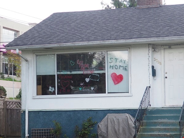
House with positive messages
https://search.heritageburnaby.ca/link/archivedescription95097
- Repository
- City of Burnaby Archives
- Date
- April 23, 2020
- Collection/Fonds
- Burnaby Photographic Society fonds
- Description Level
- Item
- Physical Description
- 1 photograph (tiff)
- Scope and Content
- Photograph of the front window of a single-storey house decorated with positive messages and drawings. Messages written on the window include "Let there be light", "Thank you", and "Stay home". The house is located at 3796 Elmwood Street.
- Repository
- City of Burnaby Archives
- Date
- April 23, 2020
- Collection/Fonds
- Burnaby Photographic Society fonds
- Physical Description
- 1 photograph (tiff)
- Description Level
- Item
- Record No.
- 623-016
- Access Restriction
- No restrictions
- Reproduction Restriction
- No restrictions
- Accession Number
- 2020-10
- Scope and Content
- Photograph of the front window of a single-storey house decorated with positive messages and drawings. Messages written on the window include "Let there be light", "Thank you", and "Stay home". The house is located at 3796 Elmwood Street.
- Subjects
- Buildings - Residential - Houses
- Media Type
- Photograph
- Photographer
- Damer, Eric
- Notes
- Transcribed title
- Geographic Access
- Elmwood Street
- Street Address
- 3796 Elmwood Street
- Planning Study Area
- Cascade-Schou Area
Images
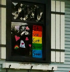
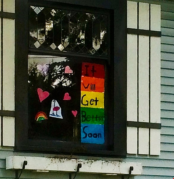
Messages of Comfort
https://search.heritageburnaby.ca/link/archivedescription95090
- Repository
- City of Burnaby Archives
- Date
- April 25, 2020
- Collection/Fonds
- Burnaby Photographic Society fonds
- Description Level
- Item
- Physical Description
- 1 photograph (tiff)
- Scope and Content
- Photograph of a window of a private residence in south east Burnaby. The window is decorated in support of health care workers with a colourful sign in the window reading: "It Will Get Better Soon".
- Repository
- City of Burnaby Archives
- Date
- April 25, 2020
- Collection/Fonds
- Burnaby Photographic Society fonds
- Physical Description
- 1 photograph (tiff)
- Description Level
- Item
- Record No.
- 623-009
- Access Restriction
- No restrictions
- Reproduction Restriction
- Reproduce for fair dealing purposes only
- Accession Number
- 2020-10
- Scope and Content
- Photograph of a window of a private residence in south east Burnaby. The window is decorated in support of health care workers with a colourful sign in the window reading: "It Will Get Better Soon".
- Subjects
- Buildings - Residential - Houses
- Media Type
- Photograph
- Photographer
- Asbia, Cher
- Notes
- Transcribed title
Images
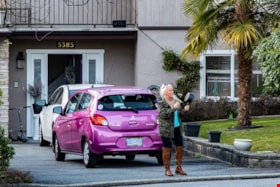
Pots & Pans
https://search.heritageburnaby.ca/link/archivedescription95124
- Repository
- City of Burnaby Archives
- Date
- April 8, 2020
- Collection/Fonds
- Burnaby Photographic Society fonds
- Description Level
- Item
- Physical Description
- 1 photograph (tiff)
- Scope and Content
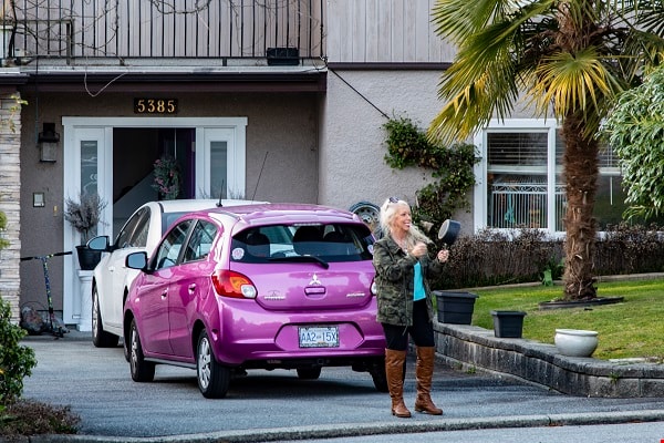
- Photograph of Burnaby resident Michelle Leone banging a pot at the end of her driveway in support of healthcare workers.
- Repository
- City of Burnaby Archives
- Date
- April 8, 2020
- Collection/Fonds
- Burnaby Photographic Society fonds
- Physical Description
- 1 photograph (tiff)
- Description Level
- Item
- Record No.
- 623-042
- Access Restriction
- No restrictions
- Reproduction Restriction
- Reproduce for fair dealing purposes only
- Accession Number
- 2020-10
- Scope and Content
- Photograph of Burnaby resident Michelle Leone banging a pot at the end of her driveway in support of healthcare workers.
- Media Type
- Photograph
- Photographer
- Jerome, Ron
- Notes
- Transcribed title
- Geographic Access
- Heathdale Court
- Street Address
- 5386 Heathdale Court
- Planning Study Area
- Parkcrest-Aubrey Area
Images

Radiate Positive Vibes
https://search.heritageburnaby.ca/link/archivedescription95085
- Repository
- City of Burnaby Archives
- Date
- May 20, 2020
- Collection/Fonds
- Burnaby Photographic Society fonds
- Description Level
- Item
- Physical Description
- 1 photograph (tiff)
- Scope and Content
- Photograph of a multi-coloured chalk drawing in the lane connecting Laurel Street and Hyde Street, at Godwin Avenue. The drawing contains the message "Radiate Positive Vibes" surrounded by wavy concentric rings.
- Repository
- City of Burnaby Archives
- Date
- May 20, 2020
- Collection/Fonds
- Burnaby Photographic Society fonds
- Physical Description
- 1 photograph (tiff)
- Description Level
- Item
- Record No.
- 623-004
- Access Restriction
- No restrictions
- Reproduction Restriction
- No restrictions
- Accession Number
- 2020-10
- Scope and Content
- Photograph of a multi-coloured chalk drawing in the lane connecting Laurel Street and Hyde Street, at Godwin Avenue. The drawing contains the message "Radiate Positive Vibes" surrounded by wavy concentric rings.
- Subjects
- Buildings - Residential - Houses
- Media Type
- Photograph
- Photographer
- Gervan, Bonnie
- Notes
- Transcribed title
- Photographer's caption: "Chalk work by young resident reminding the neighbourhood to try and stay positive during the pandemic."
- Geographic Access
- Laurel Street
- Hyde Street
- Godwin Avenue
- Historic Neighbourhood
- Burnaby Lake (Historic Neighbourhood)
- Planning Study Area
- Douglas-Gilpin Area
Images

RCMP officers saluting with firefighters
https://search.heritageburnaby.ca/link/museumdescription14750
- Repository
- Burnaby Village Museum
- Date
- 12 May 2020
- Collection/Fonds
- Burnaby Village Museum COVID-19 collection
- Description Level
- Item
- Physical Description
- 1 photograph (jpg) : col. ; 144 dpi.
- Scope and Content
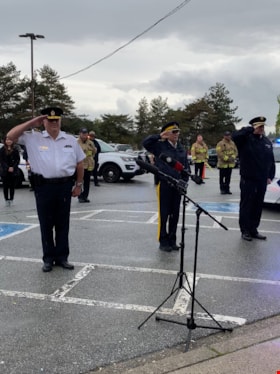
- Photograph of three RCMP officers and firefighter in the parking lot of Burnaby General Hospital. The three RCMP officers are saluting to healthcare workers.
- Repository
- Burnaby Village Museum
- Collection/Fonds
- Burnaby Village Museum COVID-19 collection
- Description Level
- Item
- Physical Description
- 1 photograph (jpg) : col. ; 144 dpi.
- Scope and Content
- Photograph of three RCMP officers and firefighter in the parking lot of Burnaby General Hospital. The three RCMP officers are saluting to healthcare workers.
- History
- Photograph was taken by Richard Liu on May 12, 2020 around 7:00pm. Richard helped organize a 'stick-tap' to salute front line health care workers at the Burnaby Hospital. The Vancouer Canuck's mascot "Fin", Mayor of Burnaby Mike Hurley, MLA Anne Kang and MLA Katrina Chen, MP Peter Juilan, the RCMP Chief, the Fire Chief and Transit Police Chief were in attendance. These 'salutes' to health care workers were common in April and May during the earliest and most uncertain months of the COVID-19 pandemic. Many local neighbourhoods across Burnaby, the Lower Mainland and the Province began regularly gathering at 7:00pm to bang pots and pans, honk horns, and generally celebrate and acknowledge the work of health care professionals. The presence of "Fin" was added because the Vancouver Canuck and NHL were not playing, so Fin was available to make the rounds. His visits were often surprises. Fin played the Canucks goal horn through the Fin Mobile roof speakers, with green and blue flashing lights. Fin visited six hospitals, as well as Canuck Place Children’s Hospice.
- Subjects
- Buildings - Civic - Hospitals
- Occupations - Civic Workers
- Occupations - Fire Fighters
- Occupations - Police Officers
- Occupations - Nurses
- Occupations - Physicians
- Pandemics - COVID-19
- Geographic Access
- Ingleton Avenue
- Street Address
- 3880 Ingleton Avenue
- Accession Code
- BV020.18.1
- Access Restriction
- No restrictions
- Reproduction Restriction
- No known restrictions
- Date
- 12 May 2020
- Media Type
- Photograph
- Historic Neighbourhood
- Broadview (Historic Neighbourhood)
- Planning Study Area
- Cascade-Schou Area
- Photographer
- Liu, Richard
- Notes
- Title based on contents of photograph
Images

Stick tap salute at Burnaby General Hospital
https://search.heritageburnaby.ca/link/museumdescription14751
- Repository
- Burnaby Village Museum
- Date
- 12 May 2020
- Collection/Fonds
- Burnaby Village Museum COVID-19 collection
- Description Level
- Item
- Physical Description
- 1 photograph (tiff) : col. ; 72 dpi.
- Scope and Content
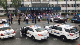
- Photograph of Burnaby General Hospital with RCMP cars, RCMP officers and healthcare workers out in front. Burnaby Mayor Mike Hurley, Vancouver Canucks' mascot "Fin", Richard Liu and another man are dressed in Vancouver Canucks hockey jerseys and are standing near the front of the hospital holding h…
- Repository
- Burnaby Village Museum
- Collection/Fonds
- Burnaby Village Museum COVID-19 collection
- Description Level
- Item
- Physical Description
- 1 photograph (tiff) : col. ; 72 dpi.
- Scope and Content
- Photograph of Burnaby General Hospital with RCMP cars, RCMP officers and healthcare workers out in front. Burnaby Mayor Mike Hurley, Vancouver Canucks' mascot "Fin", Richard Liu and another man are dressed in Vancouver Canucks hockey jerseys and are standing near the front of the hospital holding hockey sticks. They are giving a stick tap salute in appreciation to the healthcare workers.
- History
- Photograph was taken by Richard Liu on May 12, 2020 around 7:00pm. Richard helped organize a 'stick-tap' to salute front line health care workers at the Burnaby Hospital. The Vancouer Canuck's mascot "Fin", Mayor of Burnaby Mike Hurley, MLA Anne Kang and MLA Katrina Chen, MP Peter Juilan, the RCMP Chief, the Fire Chief and Transit Police Chief were in attendance. These 'salutes' to health care workers were common in April and May during the earliest and most uncertain months of the COVID-19 pandemic. Many local neighbourhoods across Burnaby, the Lower Mainland and the Province began regularly gathering at 7:00pm to bang pots and pans, honk horns, and generally celebrate and acknowledge the work of health care professionals. The presence of "Fin" was added because the Vancouver Canuck and NHL were not playing, so Fin was available to make the rounds. His visits were often surprises. Fin played the Canucks goal horn through the Fin Mobile roof speakers, with green and blue flashing lights. Fin visited six hospitals, as well as Canuck Place Children’s Hospice.
- Subjects
- Buildings - Civic - Hospitals
- Occupations - Civic Workers
- Occupations - Fire Fighters
- Occupations - Police Officers
- Occupations - Nurses
- Occupations - Physicians
- Public Services - Health Services
- Pandemics - COVID-19
- Names
- Royal Canadian Mounted Police
- Burnaby Fire Department
- Burnaby General Hospital
- Hurley, Mike
- Liu, Richard N.
- Vancouver Canucks
- Geographic Access
- Ingleton Avenue
- Street Address
- 3880 Ingleton Avenue
- Accession Code
- BV020.18.2
- Access Restriction
- No restrictions
- Reproduction Restriction
- No known restrictions
- Date
- 12 May 2020
- Media Type
- Photograph
- Historic Neighbourhood
- Broadview (Historic Neighbourhood)
- Planning Study Area
- Cascade-Schou Area
- Photographer
- Liu, Richard N.
- Notes
- Title based on contents of photograph
Images

Stick tap salute at Burnaby General Hospital
https://search.heritageburnaby.ca/link/museumdescription14752
- Repository
- Burnaby Village Museum
- Date
- 12 May 2020
- Collection/Fonds
- Burnaby Village Museum COVID-19 collection
- Description Level
- Item
- Physical Description
- 1 photograph (jpg) : col. ; 144 dpi.
- Scope and Content
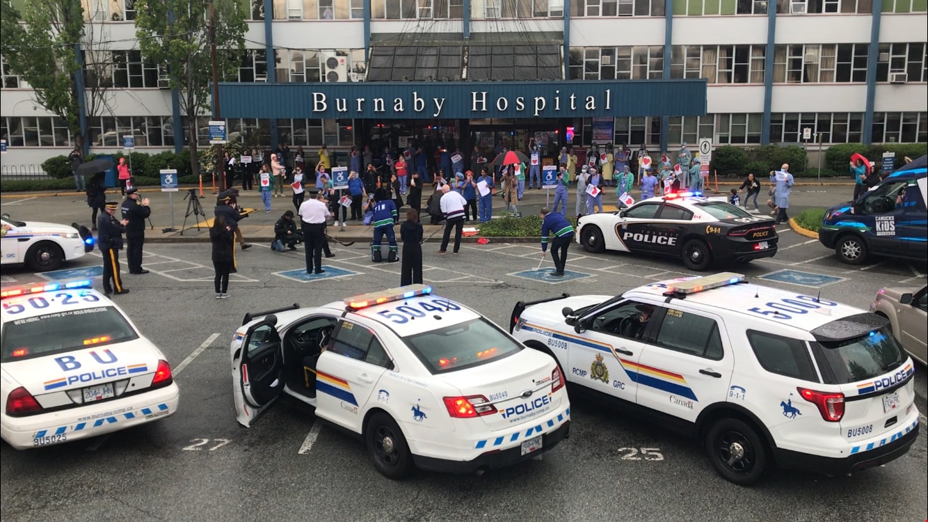
- Photograph of Burnaby Mayor, Mike Hurley (left), "Fin" the Vancouver Canucks' mascot and Richard Liu (right) with hockey sticks. The three are gathered in the parking lot outside of Burnaby General Hospital in a stick tap salute of appreciation to the healthcare workers. Mike Hurley is dressed in a…
- Repository
- Burnaby Village Museum
- Collection/Fonds
- Burnaby Village Museum COVID-19 collection
- Description Level
- Item
- Physical Description
- 1 photograph (jpg) : col. ; 144 dpi.
- Scope and Content
- Photograph of Burnaby Mayor, Mike Hurley (left), "Fin" the Vancouver Canucks' mascot and Richard Liu (right) with hockey sticks. The three are gathered in the parking lot outside of Burnaby General Hospital in a stick tap salute of appreciation to the healthcare workers. Mike Hurley is dressed in a Vancouver Canucks hockey jersey. Members of the Burnaby RCMP and Burnaby Fire Department are standing in the background along with police cars and a fire truck.
- History
- Photograph was taken by Richard Liu on May 12, 2020 around 7:00pm. Richard helped organize a 'stick-tap' to salute front line health care workers at the Burnaby Hospital. The Vancouer Canuck's mascot "Fin", Mayor of Burnaby Mike Hurley, MLA Anne Kang and MLA Katrina Chen, MP Peter Juilan, the RCMP Chief, the Fire Chief and Transit Police Chief were in attendance. These 'salutes' to health care workers were common in April and May during the earliest and most uncertain months of the COVID-19 pandemic. Many local neighbourhoods across Burnaby, the Lower Mainland and the Province began regularly gathering at 7:00pm to bang pots and pans, honk horns, and generally celebrate and acknowledge the work of health care professionals. The presence of "Fin" was added because the Vancouver Canuck and NHL were not playing, so Fin was available to make the rounds. His visits were often surprises. Fin played the Canucks goal horn through the Fin Mobile roof speakers, with green and blue flashing lights. Fin visited six hospitals, as well as Canuck Place Children’s Hospice.
- Subjects
- Buildings - Civic - Hospitals
- Occupations - Civic Workers
- Occupations - Fire Fighters
- Occupations - Police Officers
- Occupations - Nurses
- Occupations - Physicians
- Pandemics - COVID-19
- Names
- Royal Canadian Mounted Police
- Burnaby Fire Department
- Burnaby General Hospital
- Hurley, Mike
- Liu, Richard N.
- Vancouver Canucks
- Geographic Access
- Ingleton Avenue
- Street Address
- 3880 Ingleton Avenue
- Accession Code
- BV020.18.3
- Access Restriction
- No restrictions
- Reproduction Restriction
- No known restrictions
- Date
- 12 May 2020
- Media Type
- Photograph
- Historic Neighbourhood
- Broadview (Historic Neighbourhood)
- Planning Study Area
- Cascade-Schou Area
- Photographer
- Liu, Richard N.
- Notes
- Title based on contents of photograph
Images


5130 Irving Street
https://search.heritageburnaby.ca/link/archivedescription98671
- Repository
- City of Burnaby Archives
- Date
- 2022
- Collection/Fonds
- Disappearing Burnaby collection
- Description Level
- Item
- Physical Description
- 1 photograph (jpeg) : col.
- Scope and Content
- Photograph of the front steps and the entrance of a three-storey apartment building located at 5130 Irving Street. The photograph depicts the building at night, with the lobby and some of the apartments' windows illuminated from inside. The building was constructed in 1971.
- Repository
- City of Burnaby Archives
- Date
- 2022
- Collection/Fonds
- Disappearing Burnaby collection
- Physical Description
- 1 photograph (jpeg) : col.
- Description Level
- Item
- Record No.
- 634-018
- Access Restriction
- No restrictions
- Reproduction Restriction
- No restrictions
- Accession Number
- 2022-14
- Scope and Content
- Photograph of the front steps and the entrance of a three-storey apartment building located at 5130 Irving Street. The photograph depicts the building at night, with the lobby and some of the apartments' windows illuminated from inside. The building was constructed in 1971.
- Media Type
- Photograph
- Photographer
- Cheung, Nakita
- Notes
- Title taken from the associated blog post
- Associated blog post: https://disappearingburnaby.wordpress.com/2022/05/04/e-just-e/
- Geographic Access
- Irving Street
- Street Address
- 5130 Irving Street
- Historic Neighbourhood
- Central Park (Historic Neighbourhood)
- Planning Study Area
- Marlborough Area
Images


5130 Irving Street lobby
https://search.heritageburnaby.ca/link/archivedescription98672
- Repository
- City of Burnaby Archives
- Date
- 2022
- Collection/Fonds
- Disappearing Burnaby collection
- Description Level
- Item
- Physical Description
- 1 photograph (jpeg) : col.
- Scope and Content
- Photograph of the entrance of an apartment building located at 5130 Irving Street. The building was constructed in 1971. The photograph depicts the entrance and the lobby from the exterior at night. The lobby is illuminated and a crest featuring an "E" is on the entrance window.
- Repository
- City of Burnaby Archives
- Date
- 2022
- Collection/Fonds
- Disappearing Burnaby collection
- Physical Description
- 1 photograph (jpeg) : col.
- Description Level
- Item
- Record No.
- 634-019
- Access Restriction
- No restrictions
- Reproduction Restriction
- No restrictions
- Accession Number
- 2022-14
- Scope and Content
- Photograph of the entrance of an apartment building located at 5130 Irving Street. The building was constructed in 1971. The photograph depicts the entrance and the lobby from the exterior at night. The lobby is illuminated and a crest featuring an "E" is on the entrance window.
- Media Type
- Photograph
- Photographer
- Cheung, Nakita
- Notes
- Title taken from the associated blog post
- Associated blog post: https://disappearingburnaby.wordpress.com/2022/05/04/e-just-e/
- Geographic Access
- Irving Street
- Street Address
- 5130 Irving Street
- Historic Neighbourhood
- Central Park (Historic Neighbourhood)
- Planning Study Area
- Marlborough Area
Images


6280 Marlborough Avenue
https://search.heritageburnaby.ca/link/archivedescription98673
- Repository
- City of Burnaby Archives
- Date
- 2022
- Collection/Fonds
- Disappearing Burnaby collection
- Description Level
- Item
- Physical Description
- 1 photograph (jpeg) : col.
- Scope and Content
- Photograph of the front steps and entry to a three-storey apartment building, located at 6280 Marlborough Avenue. The photograph depicts the building at night and shows the brick building's details, including its lion statues and busts along the stair railings and the curved arches in front of the …
- Repository
- City of Burnaby Archives
- Date
- 2022
- Collection/Fonds
- Disappearing Burnaby collection
- Physical Description
- 1 photograph (jpeg) : col.
- Description Level
- Item
- Record No.
- 634-020
- Access Restriction
- No restrictions
- Reproduction Restriction
- No restrictions
- Accession Number
- 2022-14
- Scope and Content
- Photograph of the front steps and entry to a three-storey apartment building, located at 6280 Marlborough Avenue. The photograph depicts the building at night and shows the brick building's details, including its lion statues and busts along the stair railings and the curved arches in front of the front windows and door. The building was constructed in 1973.
- Media Type
- Photograph
- Photographer
- Cheung, Nakita
- Notes
- Title taken from the associated blog post
- Associated blog post: https://disappearingburnaby.wordpress.com/2022/05/12/marlborough-ave/
- Geographic Access
- Marlborough Avenue
- Street Address
- 6280 Marlborough Avenue
- Historic Neighbourhood
- Central Park (Historic Neighbourhood)
- Planning Study Area
- Marlborough Area
Images


6508 Silver Avenue
https://search.heritageburnaby.ca/link/archivedescription98678
- Repository
- City of Burnaby Archives
- Date
- 2022
- Collection/Fonds
- Disappearing Burnaby collection
- Description Level
- Item
- Physical Description
- 1 photograph (jpeg) : col.
- Scope and Content
- Photograph of the corner and side of the exterior of a concrete low-rise apartment building located at 6508 Silver Avenue. The photograph depicts the building at dusk. Some of the apartment windows are lit up from inside, and plant pots are lined up along the third-floor balcony. A chain link fence…
- Repository
- City of Burnaby Archives
- Date
- 2022
- Collection/Fonds
- Disappearing Burnaby collection
- Physical Description
- 1 photograph (jpeg) : col.
- Description Level
- Item
- Record No.
- 634-025
- Access Restriction
- No restrictions
- Reproduction Restriction
- No restrictions
- Accession Number
- 2022-14
- Scope and Content
- Photograph of the corner and side of the exterior of a concrete low-rise apartment building located at 6508 Silver Avenue. The photograph depicts the building at dusk. Some of the apartment windows are lit up from inside, and plant pots are lined up along the third-floor balcony. A chain link fence surrounds the backyard. The building was constructed in 1966.
- Media Type
- Photograph
- Photographer
- Cheung, Nakita
- Notes
- Title taken from the associated blog post
- Associated blog post: https://disappearingburnaby.wordpress.com/2022/06/30/brutalist/
- Geographic Access
- Silver Avenue
- Street Address
- 6508 Silver Avenue
- Historic Neighbourhood
- Central Park (Historic Neighbourhood)
- Planning Study Area
- Maywood Area
Images


6615 Telford Avenue
https://search.heritageburnaby.ca/link/archivedescription98674
- Repository
- City of Burnaby Archives
- Date
- 2022
- Collection/Fonds
- Disappearing Burnaby collection
- Description Level
- Item
- Physical Description
- 1 photograph (jpeg) : col.
- Scope and Content
- Photograph of the entrance, including the front steps and ramp, to a low-rise apartment building located at 6615 Telford Avenue. The building was constructed in 1964. The photograph depicts the building at night, and trees and bushes partially obscure the entrance. The building's lobby is illuminat…
- Repository
- City of Burnaby Archives
- Date
- 2022
- Collection/Fonds
- Disappearing Burnaby collection
- Physical Description
- 1 photograph (jpeg) : col.
- Description Level
- Item
- Record No.
- 634-021
- Access Restriction
- No restrictions
- Reproduction Restriction
- No restrictions
- Accession Number
- 2022-14
- Scope and Content
- Photograph of the entrance, including the front steps and ramp, to a low-rise apartment building located at 6615 Telford Avenue. The building was constructed in 1964. The photograph depicts the building at night, and trees and bushes partially obscure the entrance. The building's lobby is illuminated and the apartments' mailboxes are visible through the window.
- Media Type
- Photograph
- Photographer
- Cheung, Nakita
- Notes
- Title taken from the associated blog post
- Associated blog post: https://disappearingburnaby.wordpress.com/2022/06/09/martello-group/
- Geographic Access
- Telford Avenue
- Street Address
- 6615 Telford Avenue
- Historic Neighbourhood
- Central Park (Historic Neighbourhood)
- Planning Study Area
- Maywood Area
Images


6692 Dow Avenue
https://search.heritageburnaby.ca/link/archivedescription98662
- Repository
- City of Burnaby Archives
- Date
- 2022
- Collection/Fonds
- Disappearing Burnaby collection
- Description Level
- Item
- Physical Description
- 1 photograph (jpeg) : col.
- Scope and Content
- Photograph of the exterior of a two-storey apartment building located at 6692 Dow Avenue. The photograph depicts the building from across the street at night; the lobby and some of the apartment windows are lit up, with a bunch of balloons in one window, and a car is parked on the street in front o…
- Repository
- City of Burnaby Archives
- Date
- 2022
- Collection/Fonds
- Disappearing Burnaby collection
- Physical Description
- 1 photograph (jpeg) : col.
- Description Level
- Item
- Record No.
- 634-009
- Access Restriction
- No restrictions
- Reproduction Restriction
- No restrictions
- Accession Number
- 2022-14
- Scope and Content
- Photograph of the exterior of a two-storey apartment building located at 6692 Dow Avenue. The photograph depicts the building from across the street at night; the lobby and some of the apartment windows are lit up, with a bunch of balloons in one window, and a car is parked on the street in front of the building. The building was constructed in 1959.
- Media Type
- Photograph
- Photographer
- Cheung, Nakita
- Notes
- Title taken from the associated blog post
- Associated blog post: https://disappearingburnaby.wordpress.com/2022/03/01/dow-ave/
- Geographic Access
- Dow Avenue
- Street Address
- 6692 Dow Avenue
- Historic Neighbourhood
- Central Park (Historic Neighbourhood)
- Planning Study Area
- Maywood Area
Images


6700 Dow Avenue
https://search.heritageburnaby.ca/link/archivedescription98663
- Repository
- City of Burnaby Archives
- Date
- 2022
- Collection/Fonds
- Disappearing Burnaby collection
- Description Level
- Item
- Physical Description
- 1 photograph (jpeg) : col.
- Scope and Content
- Photograph of the entrance to an apartment building located at 6700 Dow Avenue. The photograph depicts the building at night; the lobby and stairs are illuminated by exterior and interior lights. The building was constructed in 1968.
- Repository
- City of Burnaby Archives
- Date
- 2022
- Collection/Fonds
- Disappearing Burnaby collection
- Physical Description
- 1 photograph (jpeg) : col.
- Description Level
- Item
- Record No.
- 634-010
- Access Restriction
- No restrictions
- Reproduction Restriction
- No restrictions
- Accession Number
- 2022-14
- Scope and Content
- Photograph of the entrance to an apartment building located at 6700 Dow Avenue. The photograph depicts the building at night; the lobby and stairs are illuminated by exterior and interior lights. The building was constructed in 1968.
- Media Type
- Photograph
- Photographer
- Cheung, Nakita
- Notes
- Title taken from the associated blog post
- Associated blog post: https://disappearingburnaby.wordpress.com/2022/03/29/no-pes/
- Geographic Access
- Dow Avenue
- Street Address
- 6700 Dow Avenue
- Historic Neighbourhood
- Central Park (Historic Neighbourhood)
- Planning Study Area
- Maywood Area
Images


Charmwood Apartments
https://search.heritageburnaby.ca/link/archivedescription98661
- Repository
- City of Burnaby Archives
- Date
- 2022
- Collection/Fonds
- Disappearing Burnaby collection
- Description Level
- Item
- Physical Description
- 1 photograph (jpeg) : col.
- Scope and Content
- Photograph of the entrance to Charmwood Apartments, a low-rise apartment building located at 6558 Sussex Avenue. The building was constructed in 1964. The photograph depicts the building at night; building's stairwell and lobby are visible from the lights shining through the windows.
- Repository
- City of Burnaby Archives
- Date
- 2022
- Collection/Fonds
- Disappearing Burnaby collection
- Physical Description
- 1 photograph (jpeg) : col.
- Description Level
- Item
- Record No.
- 634-008
- Access Restriction
- No restrictions
- Reproduction Restriction
- No restrictions
- Accession Number
- 2022-14
- Scope and Content
- Photograph of the entrance to Charmwood Apartments, a low-rise apartment building located at 6558 Sussex Avenue. The building was constructed in 1964. The photograph depicts the building at night; building's stairwell and lobby are visible from the lights shining through the windows.
- Media Type
- Photograph
- Photographer
- Cheung, Nakita
- Notes
- Title taken from the associated blog post
- Associated blog post: https://disappearingburnaby.wordpress.com/2022/03/12/charmwood-apts/
- Geographic Access
- Sussex Avenue
- Street Address
- 6558 Sussex Avenue
- Historic Neighbourhood
- Central Park (Historic Neighbourhood)
- Planning Study Area
- Maywood Area
Images
