More like 'Snow scene at Edmonds'
Narrow Results By
![Tony Fabian relaxing at a picnic table, [1970]. Item no. 549-026. thumbnail](/media/hpo/_Data/_Archives_Images/_Unrestricted/540/549-026.jpg?width=280)
Interview with Tony Fabian by Eric Damer October 10, 2012 - Track 5
https://search.heritageburnaby.ca/link/oralhistory326
- Repository
- City of Burnaby Archives
- Date Range
- 1971-2012
- Length
- 0:09:30
- Summary
- This portion of the recording pertains to Tony Fabian's memories of the development of the Fraser River Foreshore and the Confederation Community Centre (previously named Confederation House).
- Repository
- City of Burnaby Archives
- Summary
- This portion of the recording pertains to Tony Fabian's memories of the development of the Fraser River Foreshore and the Confederation Community Centre (previously named Confederation House).
- Date Range
- 1971-2012
- Photo Info
- Tony Fabian relaxing at a picnic table, [1970]. Item no. 549-026.
- Length
- 0:09:30
- Interviewer
- Damer, Eric
- Interview Date
- October 10, 2012
- Scope and Content
- Recording is an interview with Tony Fabian conducted by Burnaby Village Museum employee Eric Damer, October 10, 2012. Major theme discussed: environmental conservation practices in Burnaby.
- Biographical Notes
- Tony Fabian was born and raised in rural Saskatchewan in 1934. He and his wife moved to Burnaby in 1957, where he worked for the telephone company and raised a family. Tony has been an advocate for preservation of parklands and watercourses, helping to protect Burnaby and Deer Lake Parks and to create the Burnaby Fraser Foreshore and Barnet Marine Parks in the early nineteen-seventies, serving as a member of Burnaby’s Parks and Recreation Commission. Tony Fabian was presented with the 2008 City of Burnaby Environment Award for Community Stewardship.
- Total Tracks
- 5
- Total Length
- 0:47:48
- Interviewee Name
- Fabian, Tony
- Interview Location
- Burnaby Village Museum
- Interviewer Bio
- Eric Damer is a lifelong British Columbian born in Victoria, raised in Kamloops, and currently residing in Burnaby. After studying philosophy at the University of Victoria, he became interested in the educational forces that had shaped his own life. He completed master’s and doctoral degrees in educational studies at the University of British Columbia with a particular interest in the history of adult and higher education in the province. In 2012, Eric worked for the City of Burnaby as a field researcher and writer, conducting interviews for the City Archives and Museum Oral History Program.
- Collection/Fonds
- Community Heritage Commission Special Projects fonds
- Transcript Available
- None
- Media Type
- Sound Recording
Images
![Tony Fabian relaxing at a picnic table, [1970]. Item no. 549-026. thumbnail](/media/hpo/_Data/_Archives_Images/_Unrestricted/540/549-026.jpg)
Audio Tracks
Track five of recording of interview with Tony Fabian
Track five of recording of interview with Tony Fabian
https://search.heritageburnaby.ca/media/hpo/_Data/_Archives_Oral_Histories/_Unrestricted/MSS171-009/MSS171-009_Track_5.mp3Interview with Tony Fabian by Kathy Bossort October 29, 2015 - Track 5
https://search.heritageburnaby.ca/link/oralhistory600
- Repository
- City of Burnaby Archives
- Date Range
- 1980-2015
- Length
- 0:09:30
- Summary
- This portion of the interview is about Tony Fabian’s involvement with the Burnaby Mountain Preservation Society, further discussion about what Burnaby Mountain is good for, and his views about the kind of forest he would like to see on the mountain.
- Repository
- City of Burnaby Archives
- Summary
- This portion of the interview is about Tony Fabian’s involvement with the Burnaby Mountain Preservation Society, further discussion about what Burnaby Mountain is good for, and his views about the kind of forest he would like to see on the mountain.
- Date Range
- 1980-2015
- Length
- 0:09:30
- Names
- Burnaby Mountain Preservation Society
- Gordon, Merrill
- Lamont, Dean
- Mancinelli, Stephen J. "Steve"
- Simon Fraser University
- Geographic Access
- Burnaby Mountain Conservation Area
- Interviewer
- Bossort, Kathy
- Interview Date
- October 29, 2015
- Scope and Content
- Recording is of an interview with Tony Fabian conducted by Kathy Bossort. Tony Fabian was one of 23 participants interviewed as part of the Community Heritage Commission’s Burnaby Mountain Oral History Project. The interview is mainly about Tony Fabian’s part in park creation and protection of natural areas in Burnaby, particularly as a member of the Park and Recreation Commission in the 1970s; his childhood and how that contributed to his land ethic; and the history of the uses made of and setting aside parkland on Burnaby Mountain.
- Biographical Notes
- Tony S. Fabian was born in 1934 in north Saskatchewan. At less than a year old Tony, along with his siblings, was removed from his family home and eventually placed with an immigrant farm family. As a child he worked on the farm and witnessed what he considered abusive treatment of the land and farm animals. When he was about 12 years old his adoptive family moved to the BC coast where he went on his own, working for a variety of farmers in Richmond and Delta. At 19 he contracted polio, quit farm work, and found work with the telephone company. In 1956 Tony married, and in 1957 he and his wife moved to a home on Hardwick Street in Burnaby where he still lives. Tony entered civic politics in the 1960s when he objected to development on Hardwick Park and became concerned about the destruction of Burnaby’s natural landscapes. He became a life long advocate for preserving natural areas and helped to create large parks in Burnaby on the foreshore of the Fraser River and on Burrard Inlet. He served as a member of the Parks and Recreation Commission 1970-1975, is a long time volunteer with the Burnaby Lake Park Association, and continues to stay current on local and regional environmental issues. In 2008 Tony was presented with the City of Burnaby Environment Award for Community Stewardship.
- Total Tracks
- 7
- Total Length
- 1:43:22
- Interviewee Name
- Fabian, Tony S.
- Interview Location
- Tony Fabian's home in Burnaby
- Interviewer Bio
- Kathy Bossort is a retired archivist living in Ladner, BC. She worked at the Delta Museum and Archives after graduating from SLAIS (UBC) in 2001 with Masters degrees in library science and archival studies. Kathy grew up in Calgary, Alberta, and, prior to this career change, she lived in the West Kootenays, earning her living as a cook for BC tourist lodges and work camps. She continues to be interested in oral histories as a way to fill the gaps in the written record and bring richer meaning to history.
- Collection/Fonds
- Community Heritage Commission Special Projects fonds
- Media Type
- Sound Recording
Audio Tracks
Track five of interview with Tony Fabian
Track five of interview with Tony Fabian
https://search.heritageburnaby.ca/media/hpo/_Data/_Archives_Oral_Histories/_Unrestricted/MSS196-007/MSS196-007_Track_5.mp3![Ken Shymka at Still Creek, [1999] thumbnail](/media/hpo/_Data/_Archives_Images/_Unrestricted/535/535-3319-2.jpg?width=280)
Ken Shymka at Still Creek
https://search.heritageburnaby.ca/link/archivedescription98252
- Repository
- City of Burnaby Archives
- Date
- [1999]
- Collection/Fonds
- Burnaby NewsLeader photograph collection
- Description Level
- File
- Physical Description
- 2 photographs (tiff) : col.
- Scope and Content
- File contains photographs of photographer Ken Shymka posing with his camera at Still Creek.
- Repository
- City of Burnaby Archives
- Date
- [1999]
- Collection/Fonds
- Burnaby NewsLeader photograph collection
- Physical Description
- 2 photographs (tiff) : col.
- Description Level
- File
- Record No.
- 535-3319
- Access Restriction
- No restrictions
- Reproduction Restriction
- No restrictions
- Accession Number
- 2018-12
- Scope and Content
- File contains photographs of photographer Ken Shymka posing with his camera at Still Creek.
- Subjects
- Occupations - Photographers
- Geographic Features - Creeks
- Geographic Features - Streams
- Photographic Tools and Equipment - Camera
- Media Type
- Photograph
- Notes
- Title based on contents of file
- Collected by editorial for use in a September 1999 issue of the Burnaby NewsLeader
- Geographic Access
- Still Creek
Images
![Ken Shymka at Still Creek, [1999] thumbnail](/media/hpo/_Data/_Archives_Images/_Unrestricted/535/535-3319-2.jpg)
![Murky creek, [1999] thumbnail](/media/hpo/_Data/_Archives_Images/_Unrestricted/535/535-3259.jpg?width=280)
Murky creek
https://search.heritageburnaby.ca/link/archivedescription98181
- Repository
- City of Burnaby Archives
- Date
- [1999]
- Collection/Fonds
- Burnaby NewsLeader photograph collection
- Description Level
- Item
- Physical Description
- 1 photograph (tiff) : col.
- Scope and Content
- Photograph of an unidentified person squatting at the edge of a creek and putting their hand into the murky water.
- Repository
- City of Burnaby Archives
- Date
- [1999]
- Collection/Fonds
- Burnaby NewsLeader photograph collection
- Physical Description
- 1 photograph (tiff) : col.
- Description Level
- Item
- Record No.
- 535-3259
- Access Restriction
- No restrictions
- Reproduction Restriction
- No restrictions
- Accession Number
- 2018-12
- Scope and Content
- Photograph of an unidentified person squatting at the edge of a creek and putting their hand into the murky water.
- Media Type
- Photograph
- Notes
- Title based on original file name
- Collected by editorial for use in a July 1999 issue of the Burnaby NewsLeader
Images
![Murky creek, [1999] thumbnail](/media/hpo/_Data/_Archives_Images/_Unrestricted/535/535-3259.jpg)
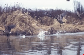
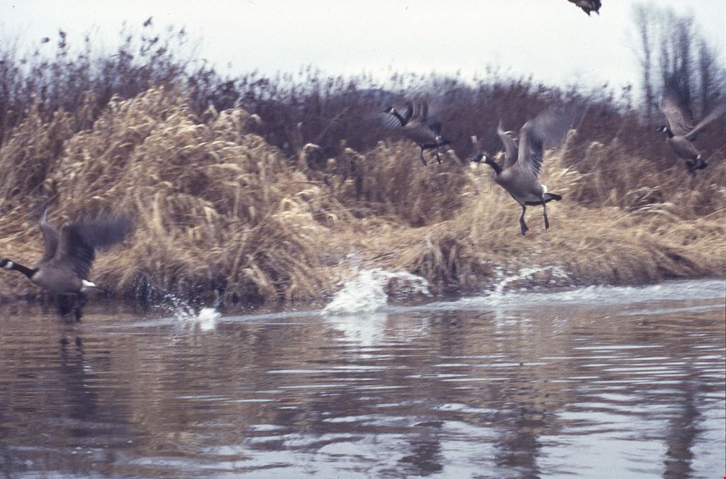
Still Creek and Burnaby Lake photographs
https://search.heritageburnaby.ca/link/archivedescription91584
- Repository
- City of Burnaby Archives
- Date
- February 3, 1998
- Collection/Fonds
- Doreen Lawson fonds
- Description Level
- File
- Physical Description
- 18 photographs : col. slides ; 35 mm
- Scope and Content
- File consists of photographs of Burnaby Lake and Still Creek, with an oil can and other debris in the water. Also included in the file are photographs of Canadian geese taking off and a man and woman kayaking on Still Creek.
- Repository
- City of Burnaby Archives
- Date
- February 3, 1998
- Collection/Fonds
- Doreen Lawson fonds
- Physical Description
- 18 photographs : col. slides ; 35 mm
- Description Level
- File
- Record No.
- 605-017
- Access Restriction
- No restrictions
- Reproduction Restriction
- No restrictions
- Accession Number
- 2003-30
- Scope and Content
- File consists of photographs of Burnaby Lake and Still Creek, with an oil can and other debris in the water. Also included in the file are photographs of Canadian geese taking off and a man and woman kayaking on Still Creek.
- Subjects
- Geographic Features - Lakes and Ponds
- Geographic Features - Forests
- Animals - Birds
- Recreational Activities
- Names
- Lawson, Doreen A.
- Media Type
- Photograph
- Photographer
- Lawson, Doreen A.
- Notes
- Title based on contents of photographs
- Geographic Access
- Burnaby Lake
- Historic Neighbourhood
- Burnaby Lake (Historic Neighbourhood)
- Planning Study Area
- Burnaby Lake Area
Images
2040-2074 Alpha Ave
https://search.heritageburnaby.ca/link/archivedescription93883
- Repository
- City of Burnaby Archives
- Date
- March 8, 1993
- Collection/Fonds
- Grover, Elliott & Co. Ltd. fonds
- Description Level
- File
- Physical Description
- 26 photographs : col. negatives ; 35 mm
- Scope and Content
- Photographs of the commercial buildings located at 2040-2074 Alpha Avenue. Stores visible in the photographs include E.B. Horsman and Bellevue.
- Repository
- City of Burnaby Archives
- Date
- March 8, 1993
- Collection/Fonds
- Grover, Elliott & Co. Ltd. fonds
- Physical Description
- 26 photographs : col. negatives ; 35 mm
- Description Level
- File
- Record No.
- 622-066
- Access Restriction
- No restrictions
- Reproduction Restriction
- No restrictions
- Accession Number
- 2017-39
- Scope and Content
- Photographs of the commercial buildings located at 2040-2074 Alpha Avenue. Stores visible in the photographs include E.B. Horsman and Bellevue.
- Media Type
- Photograph
- Notes
- Transcribed title
- Title transcribed from envelope photographs were originally housed in
- File no. 93-103-B
- Geographic Access
- Alpha Avenue
- Planning Study Area
- Dawson-Delta Area
2238 South Gilmore Ave
https://search.heritageburnaby.ca/link/archivedescription94329
- Repository
- City of Burnaby Archives
- Date
- 1995
- Collection/Fonds
- Grover, Elliott & Co. Ltd. fonds
- Description Level
- File
- Physical Description
- 36 photographs : col. negatives ; 35 mm
- Scope and Content
- Photographs of a truck trailor parking lot located at 2238 Gilmore Avenue (an address that no longer exists) and the surrounding industrial area of Gilmore Avenue and Henning Drive. File also includes photographs of the Gilmore Avenue railroad crossing one block north of Still Creek Avenue.
- Repository
- City of Burnaby Archives
- Date
- 1995
- Collection/Fonds
- Grover, Elliott & Co. Ltd. fonds
- Physical Description
- 36 photographs : col. negatives ; 35 mm
- Description Level
- File
- Record No.
- 622-114
- Access Restriction
- No restrictions
- Reproduction Restriction
- No restrictions
- Accession Number
- 2017-39
- Scope and Content
- Photographs of a truck trailor parking lot located at 2238 Gilmore Avenue (an address that no longer exists) and the surrounding industrial area of Gilmore Avenue and Henning Drive. File also includes photographs of the Gilmore Avenue railroad crossing one block north of Still Creek Avenue.
- Media Type
- Photograph
- Notes
- Transcribed title
- Title transcribed from envelope photographs were originally housed in
- File no. 95-027-B
- Geographic Access
- Gilmore Avenue
- Historic Neighbourhood
- Broadview (Historic Neighbourhood)
- Planning Study Area
- West Central Valley Area
2761 North Rd
https://search.heritageburnaby.ca/link/archivedescription94334
- Repository
- City of Burnaby Archives
- Date
- April 1995
- Collection/Fonds
- Grover, Elliott & Co. Ltd. fonds
- Description Level
- File
- Physical Description
- 24 photographs : col. negatives ; 35 mm
- Scope and Content
- Photographs of an undeveloped property located at 2761 North Road - an address that no longer exists. Three large billboards are posted at the edge of the property, facing onto the street.
- Repository
- City of Burnaby Archives
- Date
- April 1995
- Collection/Fonds
- Grover, Elliott & Co. Ltd. fonds
- Physical Description
- 24 photographs : col. negatives ; 35 mm
- Description Level
- File
- Record No.
- 622-119
- Access Restriction
- No restrictions
- Reproduction Restriction
- No restrictions
- Accession Number
- 2017-39
- Scope and Content
- Photographs of an undeveloped property located at 2761 North Road - an address that no longer exists. Three large billboards are posted at the edge of the property, facing onto the street.
- Media Type
- Photograph
- Photographer
- Young, Richard
- Notes
- Transcribed title
- Title transcribed from envelope photographs were originally housed in
- File no. 95-167-B
- Geographic Access
- North Road
- Historic Neighbourhood
- Burquitlam (Historic Neighbourhood)
- Planning Study Area
- Lyndhurst Area
3710 1st Ave
https://search.heritageburnaby.ca/link/archivedescription94330
- Repository
- City of Burnaby Archives
- Date
- February 1995
- Collection/Fonds
- Grover, Elliott & Co. Ltd. fonds
- Description Level
- File
- Physical Description
- 22 photographs : col. negatives ; 35 mm
- Scope and Content
- Photographs of the commercial property located at 3710 1st Avenue and the intersection at 1st Avenue and Boundary Road.
- Repository
- City of Burnaby Archives
- Date
- February 1995
- Collection/Fonds
- Grover, Elliott & Co. Ltd. fonds
- Physical Description
- 22 photographs : col. negatives ; 35 mm
- Description Level
- File
- Record No.
- 622-115
- Access Restriction
- No restrictions
- Reproduction Restriction
- No restrictions
- Accession Number
- 2017-39
- Scope and Content
- Photographs of the commercial property located at 3710 1st Avenue and the intersection at 1st Avenue and Boundary Road.
- Media Type
- Photograph
- Photographer
- Young, Richard
- Notes
- Transcribed title
- Title transcribed from envelope photographs were originally housed in
- File no. 95-054-B
- Geographic Access
- 1st Avenue
- Boundary Road
- Street Address
- 3710 1st Avenue
- Historic Neighbourhood
- Broadview (Historic Neighbourhood)
- Planning Study Area
- West Central Valley Area
3737 2nd Ave
https://search.heritageburnaby.ca/link/archivedescription94203
- Repository
- City of Burnaby Archives
- Date
- August 1993
- Collection/Fonds
- Grover, Elliott & Co. Ltd. fonds
- Description Level
- File
- Physical Description
- 22 photographs : col. negatives ; 35 mm
- Scope and Content
- Photographs of the exterior of a commercial building located at 3737 2nd Avenue.
- Repository
- City of Burnaby Archives
- Date
- August 1993
- Collection/Fonds
- Grover, Elliott & Co. Ltd. fonds
- Physical Description
- 22 photographs : col. negatives ; 35 mm
- Description Level
- File
- Record No.
- 622-078
- Access Restriction
- No restrictions
- Reproduction Restriction
- No restrictions
- Accession Number
- 2017-39
- Scope and Content
- Photographs of the exterior of a commercial building located at 3737 2nd Avenue.
- Media Type
- Photograph
- Notes
- Transcribed title
- Title transcribed from envelope photographs were originally housed in
- File no. 93-329-B
- Photographer identified as "L.D."
- Geographic Access
- 2nd Avenue
- Street Address
- 3737 2nd Avenue
- Historic Neighbourhood
- Broadview (Historic Neighbourhood)
- Planning Study Area
- West Central Valley Area
3900-3978 Hastings
https://search.heritageburnaby.ca/link/archivedescription93809
- Repository
- City of Burnaby Archives
- Date
- September 12, 1992
- Collection/Fonds
- Grover, Elliott & Co. Ltd. fonds
- Description Level
- File
- Physical Description
- 4 photographs : col. ; 10 cm x 15 cm
- Scope and Content
- Photographs of a two-storey commercial building located at 3900 through 3978 Hastings Street, with a residential tower visible behind it. Stores visible in the photograph include: Budget Video, a dental centre, a produce store, Autoplan Insurance, Da Vinci Travel, Great Pacific Management, and Hea…
- Repository
- City of Burnaby Archives
- Date
- September 12, 1992
- Collection/Fonds
- Grover, Elliott & Co. Ltd. fonds
- Physical Description
- 4 photographs : col. ; 10 cm x 15 cm
- Description Level
- File
- Record No.
- 622-057
- Access Restriction
- No restrictions
- Reproduction Restriction
- No restrictions
- Accession Number
- 2017-39
- Scope and Content
- Photographs of a two-storey commercial building located at 3900 through 3978 Hastings Street, with a residential tower visible behind it. Stores visible in the photograph include: Budget Video, a dental centre, a produce store, Autoplan Insurance, Da Vinci Travel, Great Pacific Management, and Head Waze Hair and Skin Studio.
- Media Type
- Photograph
- Notes
- Transcribed title
- Title transcribed from envelope photographs were originally housed in
- File no. 92-336-B
- Photographer identified as "J.C."
- Geographic Access
- Hastings Street
- Historic Neighbourhood
- Vancouver Heights (Historic Neighbourhood)
- Planning Study Area
- Burnaby Heights Area
4021 Kingsway, Burnaby
https://search.heritageburnaby.ca/link/archivedescription93882
- Repository
- City of Burnaby Archives
- Date
- February 8, 1993
- Collection/Fonds
- Grover, Elliott & Co. Ltd. fonds
- Description Level
- File
- Physical Description
- 22 photographs : col. negatives ; 35 mm
- Scope and Content
- Photographs of an undeveloped property located at 4021 Kingsway and the intersection at Kingsway and Inman Avenue.
- Repository
- City of Burnaby Archives
- Date
- February 8, 1993
- Collection/Fonds
- Grover, Elliott & Co. Ltd. fonds
- Physical Description
- 22 photographs : col. negatives ; 35 mm
- Description Level
- File
- Record No.
- 622-065
- Access Restriction
- No restrictions
- Reproduction Restriction
- No restrictions
- Accession Number
- 2017-39
- Scope and Content
- Photographs of an undeveloped property located at 4021 Kingsway and the intersection at Kingsway and Inman Avenue.
- Subjects
- Geographic Features - Roads
- Buildings
- Media Type
- Photograph
- Notes
- Transcribed title
- Title transcribed from envelope photographs were originally housed in
- File no. 93-058-B
- Geographic Access
- Kingsway
- Inman Avenue
- Street Address
- 4021 Kingsway
- Historic Neighbourhood
- Central Park (Historic Neighbourhood)
- Planning Study Area
- Garden Village Area
4250 Grange St
https://search.heritageburnaby.ca/link/archivedescription93892
- Repository
- City of Burnaby Archives
- Date
- June 1993
- Collection/Fonds
- Grover, Elliott & Co. Ltd. fonds
- Description Level
- File
- Physical Description
- 25 photographs : col. negatives ; 35 mm
- Scope and Content
- Photographs of an undeveloped property located at 4250 Grange Street - an address that no longer exists. The property's current address is 5833 Wilson Avenue. A billboard in front of the property reads: Paramount / Coming Soon / Two 21-Storey Luxury Twin Towers".
- Repository
- City of Burnaby Archives
- Date
- June 1993
- Collection/Fonds
- Grover, Elliott & Co. Ltd. fonds
- Physical Description
- 25 photographs : col. negatives ; 35 mm
- Description Level
- File
- Record No.
- 622-075
- Access Restriction
- No restrictions
- Reproduction Restriction
- No restrictions
- Accession Number
- 2017-39
- Scope and Content
- Photographs of an undeveloped property located at 4250 Grange Street - an address that no longer exists. The property's current address is 5833 Wilson Avenue. A billboard in front of the property reads: Paramount / Coming Soon / Two 21-Storey Luxury Twin Towers".
- Media Type
- Photograph
- Notes
- Transcribed title
- Title transcribed from envelope photographs were originally housed in
- File no. 93-284-B
- Photographer identified as "J.C."
- Geographic Access
- Wilson Avenue
- Grange Street
- Street Address
- 5833 Wilson Avenue
- Historic Neighbourhood
- Central Park (Historic Neighbourhood)
- Planning Study Area
- Garden Village Area
4350 Grange St
https://search.heritageburnaby.ca/link/archivedescription93886
- Repository
- City of Burnaby Archives
- Date
- March 1993
- Collection/Fonds
- Grover, Elliott & Co. Ltd. fonds
- Description Level
- File
- Physical Description
- 24 photographs : col. negatives ; 35 mm
- Scope and Content
- Photographs of an undeveloped property located at 4350 Grange Street (an address that no longer exists) and the intersection of Grange Street and Wilson Avenue.
- Repository
- City of Burnaby Archives
- Date
- March 1993
- Collection/Fonds
- Grover, Elliott & Co. Ltd. fonds
- Physical Description
- 24 photographs : col. negatives ; 35 mm
- Description Level
- File
- Record No.
- 622-069
- Access Restriction
- No restrictions
- Reproduction Restriction
- No restrictions
- Accession Number
- 2017-39
- Scope and Content
- Photographs of an undeveloped property located at 4350 Grange Street (an address that no longer exists) and the intersection of Grange Street and Wilson Avenue.
- Media Type
- Photograph
- Notes
- Transcribed title
- Title transcribed from envelope photographs were originally housed in
- File no. 93-150-B
- Photographer identified as "J.C."
- Geographic Access
- Grange Street
- Historic Neighbourhood
- Central Park (Historic Neighbourhood)
- Planning Study Area
- Garden Village Area
5573-5623 Buckingham Ave
https://search.heritageburnaby.ca/link/archivedescription94323
- Repository
- City of Burnaby Archives
- Date
- November 1994
- Collection/Fonds
- Grover, Elliott & Co. Ltd. fonds
- Description Level
- File
- Physical Description
- 37 photographs : col. negatives ; 35 mm
- Scope and Content
- Photographs of a single-family home located at 5573 Buckingham Avenue and the surrounding property. File also contains photographs of the 5500 and 5600 blocks of Bucking Avenue and the corner of Buckingham Avenue and Haszard Street.
- Repository
- City of Burnaby Archives
- Date
- November 1994
- Collection/Fonds
- Grover, Elliott & Co. Ltd. fonds
- Physical Description
- 37 photographs : col. negatives ; 35 mm
- Description Level
- File
- Record No.
- 622-108
- Access Restriction
- No restrictions
- Reproduction Restriction
- No restrictions
- Accession Number
- 2017-39
- Scope and Content
- Photographs of a single-family home located at 5573 Buckingham Avenue and the surrounding property. File also contains photographs of the 5500 and 5600 blocks of Bucking Avenue and the corner of Buckingham Avenue and Haszard Street.
- Media Type
- Photograph
- Notes
- Transcribed title
- Title transcribed from envelope photographs were originally housed in
- File no. 94-391-B
- Geographic Access
- Buckingham Avenue
- Street Address
- 5573 Buckingham Avenue
- Historic Neighbourhood
- Burnaby Lake (Historic Neighbourhood)
- Planning Study Area
- Morley-Buckingham Area
5608-5628 Imperial Street
https://search.heritageburnaby.ca/link/archivedescription94343
- Repository
- City of Burnaby Archives
- Date
- July 1995
- Collection/Fonds
- Grover, Elliott & Co. Ltd. fonds
- Description Level
- File
- Physical Description
- 25 photographs : col. negatives ; 35 mm
- Scope and Content
- Photographs of the commerical buildings located along the 5600 block of Imperial Street and the intersection at Imperial Street and Macpherson Avenue.
- Repository
- City of Burnaby Archives
- Date
- July 1995
- Collection/Fonds
- Grover, Elliott & Co. Ltd. fonds
- Physical Description
- 25 photographs : col. negatives ; 35 mm
- Description Level
- File
- Record No.
- 622-128
- Access Restriction
- No restrictions
- Reproduction Restriction
- No restrictions
- Accession Number
- 2017-39
- Scope and Content
- Photographs of the commerical buildings located along the 5600 block of Imperial Street and the intersection at Imperial Street and Macpherson Avenue.
- Media Type
- Photograph
- Notes
- Transcribed title
- Title transcribed from envelope photographs were originally housed in
- File no. 95-263-B
- Geographic Access
- Imperial Street
- MacPherson Avenue
- Street Address
- 5608 Imperial Street
- 5628 Imperial Street
- Historic Neighbourhood
- Central Park (Historic Neighbourhood)
- Planning Study Area
- Windsor Area
6622 Willingdon Ave
https://search.heritageburnaby.ca/link/archivedescription93750
- Repository
- City of Burnaby Archives
- Date
- July 18, 1990
- Collection/Fonds
- Grover, Elliott & Co. Ltd. fonds
- Description Level
- File
- Physical Description
- 20 photographs : col. negatives ; 35 mm
- Scope and Content
- Photographs of the exterior of a three-storey apartment complex located at 6622 Willingdon Avenue and the surrounding area.
- Repository
- City of Burnaby Archives
- Date
- July 18, 1990
- Collection/Fonds
- Grover, Elliott & Co. Ltd. fonds
- Physical Description
- 20 photographs : col. negatives ; 35 mm
- Description Level
- File
- Record No.
- 622-035
- Access Restriction
- No restrictions
- Reproduction Restriction
- No restrictions
- Accession Number
- 2017-39
- Scope and Content
- Photographs of the exterior of a three-storey apartment complex located at 6622 Willingdon Avenue and the surrounding area.
- Media Type
- Photograph
- Notes
- Transcribed title
- Title transcribed from envelope photographs were originally housed in
- File no. 90V-002-B
- Geographic Access
- Willingdon Avenue
- Street Address
- 6622 Willingdon Avenue
- Historic Neighbourhood
- Central Park (Historic Neighbourhood)
- Planning Study Area
- Maywood Area
6745 Station Hill Crt
https://search.heritageburnaby.ca/link/archivedescription94204
- Repository
- City of Burnaby Archives
- Date
- September 1993
- Collection/Fonds
- Grover, Elliott & Co. Ltd. fonds
- Description Level
- File
- Physical Description
- 21 photographs : col. negatives ; 35 mm
- Scope and Content
- Photographs of an undeveloped property located at 6745 Station Hill Court.
- Repository
- City of Burnaby Archives
- Date
- September 1993
- Collection/Fonds
- Grover, Elliott & Co. Ltd. fonds
- Physical Description
- 21 photographs : col. negatives ; 35 mm
- Description Level
- File
- Record No.
- 622-079
- Access Restriction
- No restrictions
- Reproduction Restriction
- No restrictions
- Accession Number
- 2017-39
- Scope and Content
- Photographs of an undeveloped property located at 6745 Station Hill Court.
- Subjects
- Geographic Features - Roads
- Media Type
- Photograph
- Notes
- Transcribed title
- Title transcribed from envelope photographs were originally housed in
- File no. 93-463-B
- Photographer identified as "K.H."
- Geographic Access
- Station Hill Court
- Street Address
- 6745 Station Hill Court
- Historic Neighbourhood
- Edmonds (Historic Neighbourhood)
- Planning Study Area
- Stride Avenue Area
6900 [and] 7000 bk Hastings St. / 7000 blk Pandora St. 200 [and] 300 blks Cliff Ave Burnaby
https://search.heritageburnaby.ca/link/archivedescription94205
- Repository
- City of Burnaby Archives
- Date
- November 1993 - December 1993
- Collection/Fonds
- Grover, Elliott & Co. Ltd. fonds
- Description Level
- File
- Physical Description
- 96 photographs : col. negatives ; 35 mm
- Scope and Content
- Photographs of various residential and commercial streets in Burnaby.
- Repository
- City of Burnaby Archives
- Date
- November 1993 - December 1993
- Collection/Fonds
- Grover, Elliott & Co. Ltd. fonds
- Physical Description
- 96 photographs : col. negatives ; 35 mm
- Description Level
- File
- Record No.
- 622-080
- Access Restriction
- No restrictions
- Reproduction Restriction
- No restrictions
- Accession Number
- 2017-39
- Scope and Content
- Photographs of various residential and commercial streets in Burnaby.
- Subjects
- Geographic Features - Roads
- Buildings - Residential - Apartments
- Buildings - Residential - Houses
- Buildings - Commercial
- Media Type
- Photograph
- Notes
- Transcribed title
- Title transcribed from envelope photographs were originally housed in
- File no. 93-455-B
- Note on negative envelope housing photographs 622-080-1 : 622-080-74 reads: "93-11-26 / Inlet Dr/Hastings, Bby, / 93-455-B"
- Note on negative envelope housing photographs 622-080-75 : 622-080-96 reads: "93-12-01 / Comp's / 93-455"
- Photographer identified as "K.H."
- Geographic Access
- Hastings Street
- Cliff Avenue
- Pandora Street
6979 Hastings St / 6941 Hastings St / 6951 Hastings St / 6939 Hastings St
https://search.heritageburnaby.ca/link/archivedescription94169
- Repository
- City of Burnaby Archives
- Date
- July 30, 1993
- Collection/Fonds
- Grover, Elliott & Co. Ltd. fonds
- Description Level
- File
- Physical Description
- 141 photographs : col. negatives ; 35 mm
- Scope and Content
- Photographs of various residential and commercial properties located throughout Burnaby. Stores visible in the photographs include Cafe Classico at 4293 Hastings Street, Firestone at 6941 Hastings Street, Coast Automatic Transmissions at 4700 Imperial Street, and Bill's Tune Up at 6979 Hastings St…
- Repository
- City of Burnaby Archives
- Date
- July 30, 1993
- Collection/Fonds
- Grover, Elliott & Co. Ltd. fonds
- Physical Description
- 141 photographs : col. negatives ; 35 mm
- Description Level
- File
- Record No.
- 622-077
- Access Restriction
- No restrictions
- Reproduction Restriction
- No restrictions
- Accession Number
- 2017-39
- Scope and Content
- Photographs of various residential and commercial properties located throughout Burnaby. Stores visible in the photographs include Cafe Classico at 4293 Hastings Street, Firestone at 6941 Hastings Street, Coast Automatic Transmissions at 4700 Imperial Street, and Bill's Tune Up at 6979 Hastings Street.
- Media Type
- Photograph
- Notes
- Transcribed title
- File nos. 93-309-B, 93-310-B, 39-308-B, and 93-307-B
- Title and file numbers transcribed from manilla envelope photographs were originally housed in.
- Date transcribed from manilla envelope photographs were originally housed in.
- File no. 93-309-B is titled "6979 Hastings St."
- File no. 93-310-B is titled "6941 Hastings St."
- File no. 93-308-B is titled "6951 Hastings St."
- File no. 93-307-B is titled "3939 Hastings St."
- It is not known which photographs were originally contained in each file.
- Photographer identified as "H., Karl"
- Geographic Access
- Hastings Street
- Imperial Street