Narrow Results By
5190 Norfolk St
https://search.heritageburnaby.ca/link/archivedescription93756
- Repository
- City of Burnaby Archives
- Date
- April 14, 1992
- Collection/Fonds
- Grover, Elliott & Co. Ltd. fonds
- Description Level
- File
- Physical Description
- 25 photographs : col. negatives ; 35 mm
- Scope and Content
- Photographs of the exterior of the Royal Oak Baptist Church located at 5190 Norfolk Street.
- Repository
- City of Burnaby Archives
- Date
- April 14, 1992
- Collection/Fonds
- Grover, Elliott & Co. Ltd. fonds
- Physical Description
- 25 photographs : col. negatives ; 35 mm
- Description Level
- File
- Record No.
- 622-041
- Access Restriction
- No restrictions
- Reproduction Restriction
- No restrictions
- Accession Number
- 2017-39
- Scope and Content
- Photographs of the exterior of the Royal Oak Baptist Church located at 5190 Norfolk Street.
- Subjects
- Buildings - Religious - Churches
- Media Type
- Photograph
- Photographer
- Young, Richard
- Notes
- Transcribed title
- Title transcribed from envelope photographs were originally housed in
- File no. 92-167-B
- Geographic Access
- Norfolk Street
- Street Address
- 5190 Norfolk Street
- Planning Study Area
- Douglas-Gilpin Area
Anniversary Sunday
https://search.heritageburnaby.ca/link/archivedescription78042
- Repository
- City of Burnaby Archives
- Date
- 2012
- Collection/Fonds
- Gordon Presbyterian Church fonds
- Description Level
- Item
- Physical Description
- 1 photograph : col ; 10 x 15 cm
- Scope and Content
- Photograph of "Anniversary Sunday" inside the Gordon Presbyterian Church, the celebration of the church's one hundredth anniversary.
- Repository
- City of Burnaby Archives
- Date
- 2012
- Collection/Fonds
- Gordon Presbyterian Church fonds
- Physical Description
- 1 photograph : col ; 10 x 15 cm
- Description Level
- Item
- Record No.
- 555-002
- Access Restriction
- In Archives only
- Reproduction Restriction
- Reproduce for fair dealing purposes only
- Accession Number
- 2013-12
- Scope and Content
- Photograph of "Anniversary Sunday" inside the Gordon Presbyterian Church, the celebration of the church's one hundredth anniversary.
- Subjects
- Buildings - Religious - Churches
- Media Type
- Photograph
- Notes
- Title based on accompanying photo identification key
- Geographic Access
- Edmonds Street
- Street Address
- 7457 Edmonds Street
- Historic Neighbourhood
- Edmonds (Historic Neighbourhood)
- Planning Study Area
- Richmond Park Area
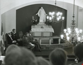
Danish Lutheran Church
https://search.heritageburnaby.ca/link/archivedescription36620
- Repository
- City of Burnaby Archives
- Date
- October 16, 1991
- Collection/Fonds
- Burnaby Historical Society fonds
- Description Level
- Item
- Physical Description
- 1 photograph : b&w ; 19 x 24 cm
- Scope and Content
- Photograph of Her Royal Highness Queen Margrethe II and Prince Henrik of Denmark attending services at the Danish Lutheran Church in Burnaby.
- Repository
- City of Burnaby Archives
- Date
- October 16, 1991
- Collection/Fonds
- Burnaby Historical Society fonds
- Subseries
- Gavel Historical Society subseries
- Physical Description
- 1 photograph : b&w ; 19 x 24 cm
- Description Level
- Item
- Record No.
- 311-002
- Access Restriction
- No restrictions
- Reproduction Restriction
- Reproduce for fair dealing purposes only
- Accession Number
- BHS1994-03
- Scope and Content
- Photograph of Her Royal Highness Queen Margrethe II and Prince Henrik of Denmark attending services at the Danish Lutheran Church in Burnaby.
- Names
- Danish Evangelical Lutheran Church of Vancouver
- Margrethe II Queen of Denmark, 1940-
- Henrik, Prince, consort of Margarethe II, Queen of Denmark, 1934-
- Media Type
- Photograph
- Photographer
- Harrison, Jim
- Notes
- Title based on contents of photograph
- Geographic Access
- Kincaid Street
- Street Address
- 6010 Kincaid Street
- Historic Neighbourhood
- Burnaby Lake (Historic Neighbourhood)
- Planning Study Area
- Douglas-Gilpin Area
Images

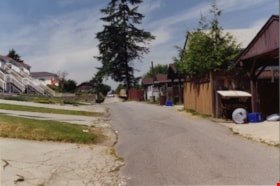
Looking west along the back lane
https://search.heritageburnaby.ca/link/archivedescription91860
- Repository
- City of Burnaby Archives
- Date
- June 1994
- Collection/Fonds
- Small family fonds
- Description Level
- Item
- Physical Description
- 1 photograph : col. copy print ; 10 cm x 15 cm
- Scope and Content
- Photograph of the back lane between Dominion Street and Norfolk Street, looking west. The fir tree in the centre of the photograph is one of many planted by John Roberts along the south property line of 5538 Dominion Street. The other trees were removed in 1982 when the Roberts' property was larg…
- Repository
- City of Burnaby Archives
- Date
- June 1994
- Collection/Fonds
- Small family fonds
- Physical Description
- 1 photograph : col. copy print ; 10 cm x 15 cm
- Description Level
- Item
- Record No.
- 620-041
- Access Restriction
- No restrictions
- Reproduction Restriction
- No reproduction permitted
- Accession Number
- 2017-01
- Scope and Content
- Photograph of the back lane between Dominion Street and Norfolk Street, looking west. The fir tree in the centre of the photograph is one of many planted by John Roberts along the south property line of 5538 Dominion Street. The other trees were removed in 1982 when the Roberts' property was largely cleared in order to relocate the house 100 feet west and subdivide the property into 33 foot lots.
- Subjects
- Geographic Features - Lanes
- Media Type
- Photograph
- Notes
- Transcribed title
- Title transcribed from donor's notes
- Note in blue ink on verso of photograph reads: "P.4"
- Note in blue ink on verso of photograph reads: "The Back lane behind 3131 Douglas Rd to 5496 etc Dominion St. / June 1994"
- 5118 Douglas Road renumbered to 3131 Douglas Road in 1958 and to 5538 Dominion Street in 1970 or 1971
- Street Address
- 3131 Douglas Road
- 5118 Douglas Road
- 5538 Dominion Street
- Historic Neighbourhood
- Burnaby Lake (Historic Neighbourhood)
- Planning Study Area
- Ardingley-Sprott Area
Images


Looking west along the back lane
https://search.heritageburnaby.ca/link/archivedescription91861
- Repository
- City of Burnaby Archives
- Date
- April 2015
- Collection/Fonds
- Small family fonds
- Description Level
- Item
- Physical Description
- 1 photograph : col. ; 10 cm x 15 cm
- Scope and Content
- Photograph of the back lane between Dominion Street and Norfolk Street, looking west. Visible along the Norfolk Street side of the lane are houses with garages and longer driveways. Along the Dominion Street side the lane is abutted by trees and open carports. The houses along Norfolk Street wer…
- Repository
- City of Burnaby Archives
- Date
- April 2015
- Collection/Fonds
- Small family fonds
- Physical Description
- 1 photograph : col. ; 10 cm x 15 cm
- Description Level
- Item
- Record No.
- 620-042
- Access Restriction
- No restrictions
- Reproduction Restriction
- No reproduction permitted
- Accession Number
- 2017-01
- Scope and Content
- Photograph of the back lane between Dominion Street and Norfolk Street, looking west. Visible along the Norfolk Street side of the lane are houses with garages and longer driveways. Along the Dominion Street side the lane is abutted by trees and open carports. The houses along Norfolk Street were constructed in the 1980s and 1990s following the rezoning of the properties.
- Media Type
- Photograph
- Notes
- Transcribed title
- Title transcribed from donor's notes
- Note in blue ink on verso of photograph reads: "P.5"
- Note in blue ink on verso of photograph reads: "April 1, 2015"
- Historic Neighbourhood
- Burnaby Lake (Historic Neighbourhood)
- Planning Study Area
- Ardingley-Sprott Area
Images


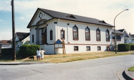
Vancouver Heights Presbyterian Church
https://search.heritageburnaby.ca/link/archivedescription38238
- Repository
- City of Burnaby Archives
- Date
- 1998
- Collection/Fonds
- Burnaby Historical Society fonds
- Description Level
- Item
- Physical Description
- 1 photograph : col. ; 15 x 25 cm
- Scope and Content
- Photograph of two unidentified women walking a dog past the Vancouver Heights Presbyterian Church.
- Repository
- City of Burnaby Archives
- Date
- 1998
- Collection/Fonds
- Burnaby Historical Society fonds
- Subseries
- Photographs subseries
- Physical Description
- 1 photograph : col. ; 15 x 25 cm
- Description Level
- Item
- Record No.
- 373-001
- Access Restriction
- No restrictions
- Reproduction Restriction
- Reproduce for fair dealing purposes only
- Accession Number
- BHS2007-04
- Scope and Content
- Photograph of two unidentified women walking a dog past the Vancouver Heights Presbyterian Church.
- Subjects
- Buildings - Religious - Churches
- Media Type
- Photograph
- Notes
- Title based on contents of photograph
- Geographic Access
- Esmond Avenue
- Street Address
- 140 Esmond Avenue
- Historic Neighbourhood
- Vancouver Heights (Historic Neighbourhood)
- Planning Study Area
- Burnaby Heights Area
Images
Welcoming visitors
https://search.heritageburnaby.ca/link/archivedescription78075
- Repository
- City of Burnaby Archives
- Date
- 2012
- Collection/Fonds
- Gordon Presbyterian Church fonds
- Description Level
- Item
- Physical Description
- 1 photograph : col ; 10 x 15 cm
- Scope and Content
- Photograph of affiliates of the Gordon Presbyterian Church "welcoming visitors" to the church's one hundredth anniversary.
- Repository
- City of Burnaby Archives
- Date
- 2012
- Collection/Fonds
- Gordon Presbyterian Church fonds
- Physical Description
- 1 photograph : col ; 10 x 15 cm
- Description Level
- Item
- Record No.
- 555-005
- Access Restriction
- In Archives only
- Reproduction Restriction
- Reproduce for fair dealing purposes only
- Accession Number
- 2013-12
- Scope and Content
- Photograph of affiliates of the Gordon Presbyterian Church "welcoming visitors" to the church's one hundredth anniversary.
- Subjects
- Buildings - Religious - Churches
- Media Type
- Photograph
- Notes
- Title based on accompanying photo identification key
- Geographic Access
- Edmonds Street
- Street Address
- 7457 Edmonds Street
- Historic Neighbourhood
- Edmonds (Historic Neighbourhood)
- Planning Study Area
- Richmond Park Area