More like 'Painting new false front of Whitechurch Hardware building'
Narrow Results By
Subject
- Advertising Medium - Signs and Signboards 1
- Buildings - Civic - Community Centres 1
- Buildings - Civic - Museums 1
- Buildings - Commercial 10
- Buildings - Commercial - Malls 2
- Buildings - Commercial - Stores 1
- Buildings - Commercial - Train Stations 1
- Buildings - Heritage 3
- Buildings - Industrial 7
- Buildings - Residential 3
- Buildings - Residential - Apartments 4
- Buildings - Residential - Houses 4
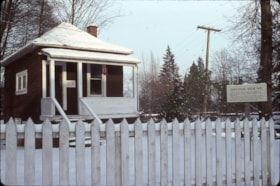
Heritage Village
https://search.heritageburnaby.ca/link/archivedescription91713
- Repository
- City of Burnaby Archives
- Date
- January 1985
- Collection/Fonds
- Doreen Lawson fonds
- Description Level
- File
- Physical Description
- 20 photographs : col. slides ; 35 mm
- Scope and Content
- File consists of photographs of Heritage Village (Burnaby Village Museum) in the snow. Buildings depicted in the photographs include: Jubilee Music store, optometrist, Electric Theatre, real estate office, Chinese Herbalist store, church, and Village blacksmith. Also included in the file are photo…
- Repository
- City of Burnaby Archives
- Date
- January 1985
- Collection/Fonds
- Doreen Lawson fonds
- Physical Description
- 20 photographs : col. slides ; 35 mm
- Description Level
- File
- Record No.
- 618-031
- Access Restriction
- No restrictions
- Reproduction Restriction
- No restrictions
- Accession Number
- 2015-15
- Scope and Content
- File consists of photographs of Heritage Village (Burnaby Village Museum) in the snow. Buildings depicted in the photographs include: Jubilee Music store, optometrist, Electric Theatre, real estate office, Chinese Herbalist store, church, and Village blacksmith. Also included in the file are photographs of the Heritage Burnaby entrance sign and donation plaque for the Japanese Bathhouse.
- Names
- Burnaby Village Museum
- Media Type
- Photograph
- Photographer
- Lawson, Doreen A.
- Notes
- Transcribed title
- Title transcribed from label on original slide cases
- Street Address
- 6501 Deer Lake Avenue
- Historic Neighbourhood
- Burnaby Lake (Historic Neighbourhood)
- Planning Study Area
- Morley-Buckingham Area
Images
Mountainside Village Commercial / 8650 Cinnamon Drive
https://search.heritageburnaby.ca/link/archivedescription93714
- Repository
- City of Burnaby Archives
- Date
- 1987
- Collection/Fonds
- Grover, Elliott & Co. Ltd. fonds
- Description Level
- File
- Physical Description
- 7 photographs : col. ; 10 cm x 15 cm
- Scope and Content
- Photographs of the Mountainside Village Shops commerical complex located at 8650 Cinnamon Drive. Stores visible in the photographs include Video Link, Country Hair, and Pizza and Pastry.
- Repository
- City of Burnaby Archives
- Date
- 1987
- Collection/Fonds
- Grover, Elliott & Co. Ltd. fonds
- Physical Description
- 7 photographs : col. ; 10 cm x 15 cm
- Description Level
- File
- Record No.
- 622-003
- Access Restriction
- No restrictions
- Reproduction Restriction
- No restrictions
- Accession Number
- 2017-39
- Scope and Content
- Photographs of the Mountainside Village Shops commerical complex located at 8650 Cinnamon Drive. Stores visible in the photographs include Video Link, Country Hair, and Pizza and Pastry.
- Subjects
- Buildings - Commercial - Stores
- Media Type
- Photograph
- Notes
- Transcribed title
- Title transcribed from original print envelope
- File no. 87-190-B
- Geographic Access
- Cinnamon Drive
- Street Address
- 8650 Cinnamon Drive
- Planning Study Area
- Lake City Area

Metrotown Station Square
https://search.heritageburnaby.ca/link/archivedescription93745
- Repository
- City of Burnaby Archives
- Date
- November 1989
- Collection/Fonds
- Grover, Elliott & Co. Ltd. fonds
- Description Level
- File
- Physical Description
- 83 photographs : col. negatives ; 35 mm + 2 computer disks ; 14 x 14 cm
- Scope and Content
- Photographs of Metrotown Station Square during construction. Businesses visible in the photographs include: Eastons, Holiday Inn, Future Shop, Great Canadian Superstore, and Toy City Consumers.
- Repository
- City of Burnaby Archives
- Date
- November 1989
- Collection/Fonds
- Grover, Elliott & Co. Ltd. fonds
- Physical Description
- 83 photographs : col. negatives ; 35 mm + 2 computer disks ; 14 x 14 cm
- Description Level
- File
- Record No.
- 622-030
- Access Restriction
- No restrictions
- Reproduction Restriction
- No restrictions
- Accession Number
- 2017-39
- Scope and Content
- Photographs of Metrotown Station Square during construction. Businesses visible in the photographs include: Eastons, Holiday Inn, Future Shop, Great Canadian Superstore, and Toy City Consumers.
- Media Type
- Photograph
- Notes
- Transcribed title
- Title transcribed from print envelopes photographs were originally housed in
- File no. 89-512-B
- Computer disks are labelled "Station Square Metro Town Nov /89". Computer disk envelopes are labelled "Suite 660-1380 Burrard ST / Van, BC"
- Geographic Access
- McKay Avenue
- Street Address
- 6200 McKay Avenue
- Historic Neighbourhood
- Central Park (Historic Neighbourhood)
- Planning Study Area
- Maywood Area
Images

Family interviews
https://search.heritageburnaby.ca/link/museumdescription9831
- Repository
- Burnaby Village Museum
- Date
- 1989-1997
- Collection/Fonds
- Burnaby Village Museum fonds
- Description Level
- File
- Physical Description
- 2 cm of textual records
- Scope and Content
- File consists of several pages of handwritten documents with notes and interview questions transcribed by Lisa Langlet. These notes were taken during telephone and in person interviews between Lisa Langlet (or Jim Wolf) and members of the Love family including: Albert Parker; Esther Stanley (nee Lo…
- Repository
- Burnaby Village Museum
- Collection/Fonds
- Burnaby Village Museum fonds
- Series
- Jesse Love farmhouse series
- Subseries
- Love farmhouse research files subseries
- Description Level
- File
- Physical Description
- 2 cm of textual records
- Scope and Content
- File consists of several pages of handwritten documents with notes and interview questions transcribed by Lisa Langlet. These notes were taken during telephone and in person interviews between Lisa Langlet (or Jim Wolf) and members of the Love family including: Albert Parker; Esther Stanley (nee Love); Leonard Love; Mrs. Bill Parker; Annie Chamberlain (nee McKenzie); Ruth Boruck (nee Love); Elsie Hughes (nee Parker) and Gordon Love. Notes include information about growing up and living in the house on Cumberland Street. This information was used by the curator to assist in designing the exhibits within the farmhouse. Information in these interviews was broken down into references to rooms within the house, gardens, outbuildings and activities at home.
- Subjects
- Buildings - Heritage
- Names
- Parker, Albert "Bert"
- Love, John Leonard
- Stanley, Esther Love
- Chamberlain, Annie McKenzie
- Love, Gordon Wesley
- Hughes, Elsie Roberta Parker
- Accession Code
- BV018.41.44
- Access Restriction
- Subject to FIPPA
- Reproduction Restriction
- Reproductions subject to FIPPA
- Date
- 1989-1997
- Media Type
- Textual Record
- Notes
- Title based on content of file
Jesse Love house - Photographic documentation of changes and move
https://search.heritageburnaby.ca/link/museumdescription9873
- Repository
- Burnaby Village Museum
- Date
- 1988
- Collection/Fonds
- Burnaby Village Museum fonds
- Description Level
- File
- Physical Description
- Approx. 274 photographs : col. , b&w negatives ; 35 mm + 24 photographs : b&w ; 9 x 13.5 cm
- Scope and Content
- File consists of a collection of photographs which were taken between April 8 and May 20, 1988 by Jim Wolf to document the Love farmhouse from it's original location at 7651 Cumberland Street (the corner of 14th Avenue and Cumberland Street) and the move to the Burnaby Village Museum site. The purp…
- Repository
- Burnaby Village Museum
- Collection/Fonds
- Burnaby Village Museum fonds
- Series
- Jesse Love farmhouse series
- Description Level
- File
- Physical Description
- Approx. 274 photographs : col. , b&w negatives ; 35 mm + 24 photographs : b&w ; 9 x 13.5 cm
- Scope and Content
- File consists of a collection of photographs which were taken between April 8 and May 20, 1988 by Jim Wolf to document the Love farmhouse from it's original location at 7651 Cumberland Street (the corner of 14th Avenue and Cumberland Street) and the move to the Burnaby Village Museum site. The purpose of this documentary collection was to help capture the original character of the house and record any evident changes over time as modern renovations were discovered along with any changes that were made in order to move the house from it's original site to the museum. Jim Wolf created a "Love House Photo Index" including descriptions for most of the photographs that he created. Film "Rolls A-E" were taken of the house once it was saved and acquired by the Burnaby Village Museum. Film "Rolls F & G" were taken prior to this event and were meant to provide evidence for preserving the house and create a permanent record of an historic building - with the imminent threat of its destruction. Interior shots of the upstairs of the house were recorded on film roll "D" according to another alphabetic system that was used to record each "artifact" ie: fixtures, walls, moulding etc. since there was a good possibility that the mid-section of the second floor would be severed and/or damaged once the kitchen was removed in order to transport the house. Film "roll E" and several other rolls have an emphasis on the kitchen because of the threat of its individual destruction given budgetary, spatial and other constraints.
- Subjects
- Buildings - Heritage
- Geographic Access
- Cumberland Street
- Street Address
- 7651 Cumberland Street
- Accession Code
- BV018.41.82
- Access Restriction
- No restrictions
- Reproduction Restriction
- May be restricted by third party rights
- Date
- 1988
- Media Type
- Photograph
- Photographer
- Wolf, Jim
- Notes
- Title based on content of file
- 284 b&w and col. prints accompanying (most are copies of the original negatives)
Love farmhouse restoration photographs
https://search.heritageburnaby.ca/link/museumdescription9872
- Repository
- Burnaby Village Museum
- Date
- 1988-1999, predominant 1996-1998
- Collection/Fonds
- Burnaby Village Museum fonds
- Description Level
- File
- Physical Description
- Approx. 728 photographs : col. ; 10.5 x 15.5` cm + col. slides ; 35 mm + col. negatives ; 35 mm + b&w negatives ; 35 mm
- Scope and Content
- File consists of a large binder containing photographs documenting the restoration and conservation of the Love farmhouse after it was moved to the Burnaby Village Museum site in May 1988. Photographs were arranged by Conservator, Elisabeth Czerwinski and are indexed and divided into the following …
- Repository
- Burnaby Village Museum
- Collection/Fonds
- Burnaby Village Museum fonds
- Series
- Jesse Love farmhouse series
- Description Level
- File
- Physical Description
- Approx. 728 photographs : col. ; 10.5 x 15.5` cm + col. slides ; 35 mm + col. negatives ; 35 mm + b&w negatives ; 35 mm
- Scope and Content
- File consists of a large binder containing photographs documenting the restoration and conservation of the Love farmhouse after it was moved to the Burnaby Village Museum site in May 1988. Photographs were arranged by Conservator, Elisabeth Czerwinski and are indexed and divided into the following subjects: 1) Intial Roof and shingle condition- reroofing 2) Porches - rebuilding (1994) 3) Windows (1995) 4) Shingles and Painting [1997] 5) Front Hallway, Dining Room and Bedroom - doors / paint (1996-1999) 6) Wallpaper (1998) 7) Chimney / Fire break / Kitchen before wall moved (1996-1998) 8) Kitchen Ceilings - wires to lights (1997) 9) Dining Room - ceiling and walls [1997] 10) Front Bedroom - original wallpaper (1997) 11) Front Hallway - tin ceiling, wallpaper (1996-1999) 12) Dining Room closet - wallpaper (1995-1997) 13) Kitchen (1996-1997) 14) Kitchen / Dining Room / doorway floor (1996-1997) 15) Front bedroom - door closed in / Kitchen wall finished (1997) 16) New Kitchen side door (1997) 17) Music Room - tin ceiling - paint history (1996-1997) 18) Kitchen paint sandings [1996-1997] 19) Pantry floor and walls ( 1997) 20) Love farmhouse after restoration (1999) 21) Water damage [1997-1998] 22) Heating panels in ceiling (1997) 23) Intial house move to BVM - removing roof - Kitchen reattached - paint on siding (1988-1998) 24) Wallpaper - installlation (1998) 25) Roof repairs
- Subjects
- Buildings - Heritage
- Names
- Burnaby Village Museum
- Accession Code
- BV018.41.81
- Access Restriction
- No restrictions
- Reproduction Restriction
- No known restrictions
- Date
- 1988-1999, predominant 1996-1998
- Media Type
- Photograph
- Notes
- Title based on contents of file
- A selection of 171 photographs have been scanned and described at item level - see BV018.41.523 to BV018.41.694
![Edmonds House fire, [after 4 Dec. 1982] thumbnail](/media/hpo/_Data/_Archives_Images/_Restricted/580/680-036-1.jpg?width=280)
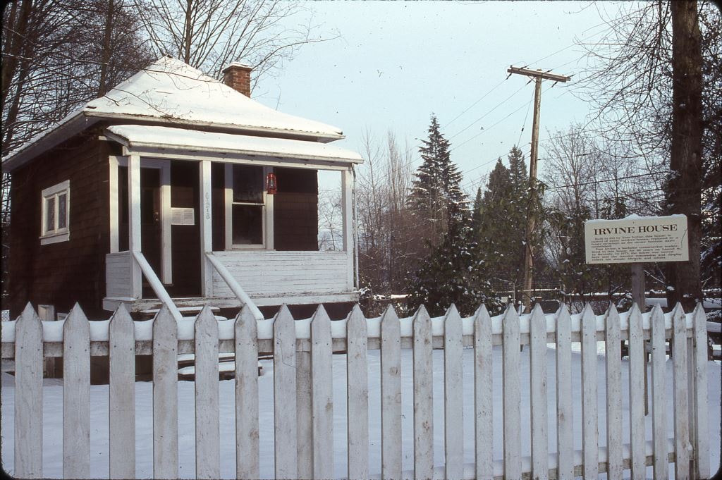
Edmonds House fire
https://search.heritageburnaby.ca/link/archivedescription91730
- Repository
- City of Burnaby Archives
- Date
- [after 4 Dec. 1982]
- Collection/Fonds
- Doreen Lawson fonds
- Description Level
- File
- Physical Description
- 5 photographs : col. negatives ; 35 mm
- Scope and Content
- File consists of photographs that document the damage caused by a fire at the Edmonds Community Centre for the Retired (also known as Edmonds House). Three of these photographs were enlarged through the inter-negative process to 11'' x 14'' col. prints for a juried exhibition of British Columbian P…
- Repository
- City of Burnaby Archives
- Date
- [after 4 Dec. 1982]
- Collection/Fonds
- Doreen Lawson fonds
- Physical Description
- 5 photographs : col. negatives ; 35 mm
- Description Level
- File
- Record No.
- 618-036
- Access Restriction
- No restrictions
- Reproduction Restriction
- No restrictions
- Accession Number
- 2015-15
- Scope and Content
- File consists of photographs that document the damage caused by a fire at the Edmonds Community Centre for the Retired (also known as Edmonds House). Three of these photographs were enlarged through the inter-negative process to 11'' x 14'' col. prints for a juried exhibition of British Columbian Photographers, put on by the Burnaby Photographic Society in 1988.
- Names
- Edmonds House
- Media Type
- Photograph
- Photographer
- Lawson, Doreen A.
- Notes
- Title based on contents of photographs
- Note in blue ink on ABC Photocolor envelope reads: "Print Full Frame"
- Historic Neighbourhood
- Edmonds (Historic Neighbourhood)
Images
![Edmonds House fire, [after 4 Dec. 1982] thumbnail](/media/hpo/_Data/_Archives_Images/_Restricted/580/680-036-1.jpg)
3000, 3100, 3200 Beta Ave
https://search.heritageburnaby.ca/link/archivedescription93739
- Repository
- City of Burnaby Archives
- Date
- 1989
- Collection/Fonds
- Grover, Elliott & Co. Ltd. fonds
- Description Level
- File
- Physical Description
- 40 photographs : col. negatives ; 35 mm
- Scope and Content
- Photographs of the commercial buildings and loading bays located at 3000, 3100, and 3200 Beta Avenue.
- Repository
- City of Burnaby Archives
- Date
- 1989
- Collection/Fonds
- Grover, Elliott & Co. Ltd. fonds
- Physical Description
- 40 photographs : col. negatives ; 35 mm
- Description Level
- File
- Record No.
- 622-024
- Access Restriction
- No restrictions
- Reproduction Restriction
- No restrictions
- Accession Number
- 2017-39
- Scope and Content
- Photographs of the commercial buildings and loading bays located at 3000, 3100, and 3200 Beta Avenue.
- Subjects
- Buildings - Commercial
- Media Type
- Photograph
- Notes
- Transcribed title
- Title transcribed from print envelope photographs were originally housed in
- File no. 89-214-B
- Geographic Access
- Beta Avenue
- Street Address
- 3000 Beta Avenue
- 3100 Beta Avenue
- 3200 Beta Avenue
- Planning Study Area
- Douglas-Gilpin Area
3650 Bonneville Place
https://search.heritageburnaby.ca/link/archivedescription93737
- Repository
- City of Burnaby Archives
- Date
- March 1989
- Collection/Fonds
- Grover, Elliott & Co. Ltd. fonds
- Description Level
- File
- Physical Description
- 8 photographs : col. ; 10 cm x 15 cm
- Scope and Content
- Photographs of the commercial complex located at 3650 Bonneville Place. Phase I of the complex is complete and Phase II is under construction. Businesses visible in the photographs include Four Seasons Greenhouses and Shaw.
- Repository
- City of Burnaby Archives
- Date
- March 1989
- Collection/Fonds
- Grover, Elliott & Co. Ltd. fonds
- Physical Description
- 8 photographs : col. ; 10 cm x 15 cm
- Description Level
- File
- Record No.
- 622-022
- Access Restriction
- No restrictions
- Reproduction Restriction
- No restrictions
- Accession Number
- 2017-39
- Scope and Content
- Photographs of the commercial complex located at 3650 Bonneville Place. Phase I of the complex is complete and Phase II is under construction. Businesses visible in the photographs include Four Seasons Greenhouses and Shaw.
- Subjects
- Buildings - Commercial
- Construction
- Media Type
- Photograph
- Notes
- Transcribed title
- Title transcribed from sticky note adhered to photograph 622-022-1
- File no. 89-124-B
- Photograph 622-022-1 captions reads: "3650 Bonneville - south view"
- Photograph 622-022-2 caption reads: "North and east facade"
- Photograph 622-022-3 caption reads: "View north along Broadway Street; Note entry bridges"
- Photograph 622-022-4 caption reads: "Southern view along Broadway Street"
- Photograph 622-022-5 caption reads: "Front facade and main entry for Phase I"
- Photograph 622-022-6 caption reads: "Rear and loading facilities for Phase I"
- Photograph 622-022-7 caption reads: "View west to Phase II from entry driveway"
- Photograph 622-022-8 caption reads: "Site preparation for Phase I
- Photograph captions transcribed from the paper on which the photographs were originally adhered.
- Geographic Access
- Bonneville Place
- Street Address
- 3650 Bonneville Place
- Planning Study Area
- Lake City Area
5499-5495 Regent Street / 2857 Douglas Road
https://search.heritageburnaby.ca/link/archivedescription93713
- Repository
- City of Burnaby Archives
- Date
- 1987
- Collection/Fonds
- Grover, Elliott & Co. Ltd. fonds
- Description Level
- File
- Physical Description
- 24 photographs : col. negatives ; 35 mm
- Scope and Content
- Photographs of the building exterior and loading bays of Loomis, located at 5499 and 5495 Regent Street, and of 2857 Douglas Road. 5499 and 5495 Regent Street are addresses that no longer exist; the current address is 5491 Regent Street.
- Repository
- City of Burnaby Archives
- Date
- 1987
- Collection/Fonds
- Grover, Elliott & Co. Ltd. fonds
- Physical Description
- 24 photographs : col. negatives ; 35 mm
- Description Level
- File
- Record No.
- 622-002
- Access Restriction
- No restrictions
- Reproduction Restriction
- No restrictions
- Accession Number
- 2017-39
- Scope and Content
- Photographs of the building exterior and loading bays of Loomis, located at 5499 and 5495 Regent Street, and of 2857 Douglas Road. 5499 and 5495 Regent Street are addresses that no longer exist; the current address is 5491 Regent Street.
- Media Type
- Photograph
- Notes
- Transcribed title
- Title transcribed from original print envelope
- File no. 87-133-B
- Geographic Access
- Douglas Road
- Regent Street
- Street Address
- 2857 Douglas Road
- 5491 Regent Street
- Historic Neighbourhood
- Burnaby Lake (Historic Neighbourhood)
- Planning Study Area
- Dawson-Delta Area
5608 to 5628 Imperial Street
https://search.heritageburnaby.ca/link/archivedescription93730
- Repository
- City of Burnaby Archives
- Date
- 1989
- Collection/Fonds
- Grover, Elliott & Co. Ltd. fonds
- Description Level
- File
- Physical Description
- 16 photographs : col. negatives ; 35 mm
- Scope and Content
- Photographs of the commerical properties located between 5608 and 5628 Imperial Street and the intersection at Imperial Street and MacPherson Avenue. Businesses visible in the photographs include Galaxie Collision, Minit-tune, and Canadian Cash and Carry Tire Centre.
- Repository
- City of Burnaby Archives
- Date
- 1989
- Collection/Fonds
- Grover, Elliott & Co. Ltd. fonds
- Physical Description
- 16 photographs : col. negatives ; 35 mm
- Description Level
- File
- Record No.
- 622-018
- Access Restriction
- No restrictions
- Reproduction Restriction
- No restrictions
- Accession Number
- 2017-39
- Scope and Content
- Photographs of the commerical properties located between 5608 and 5628 Imperial Street and the intersection at Imperial Street and MacPherson Avenue. Businesses visible in the photographs include Galaxie Collision, Minit-tune, and Canadian Cash and Carry Tire Centre.
- Media Type
- Photograph
- Photographer
- Young, J.
- Notes
- Transcribed title
- Title transcribed from original print envelope
- Geographic Access
- Imperial Street
- MacPherson Avenue
- Street Address
- 5608 Imperial Street
- 5628 Imperial Street
- Historic Neighbourhood
- Central Park (Historic Neighbourhood)
- Planning Study Area
- Windsor Area
5621 Imperial Street
https://search.heritageburnaby.ca/link/archivedescription93712
- Repository
- City of Burnaby Archives
- Date
- 1987
- Collection/Fonds
- Grover, Elliott & Co. Ltd. fonds
- Description Level
- File
- Physical Description
- 8 photographs : col. ; 10 cm x 15 cm
- Scope and Content
- Photographs of the exterior of the commerical property located at 5621 Imperial Street.
- Repository
- City of Burnaby Archives
- Date
- 1987
- Collection/Fonds
- Grover, Elliott & Co. Ltd. fonds
- Physical Description
- 8 photographs : col. ; 10 cm x 15 cm
- Description Level
- File
- Record No.
- 622-001
- Access Restriction
- No restrictions
- Reproduction Restriction
- No restrictions
- Accession Number
- 2017-39
- Scope and Content
- Photographs of the exterior of the commerical property located at 5621 Imperial Street.
- Subjects
- Buildings - Commercial
- Media Type
- Photograph
- Notes
- Transcribed title
- Title transcribed from original print envelope
- File no. 87-056-B
- Geographic Access
- Imperial Street
- Street Address
- 5621 Imperial Street
- Historic Neighbourhood
- Central Park (Historic Neighbourhood)
- Planning Study Area
- Windsor Area
7018-7092 Lougheed Hwy [at] SW intersection w/ Bainbridge Ave
https://search.heritageburnaby.ca/link/archivedescription93715
- Repository
- City of Burnaby Archives
- Date
- 1987
- Collection/Fonds
- Grover, Elliott & Co. Ltd. fonds
- Description Level
- File
- Physical Description
- 17 photographs : col. ; 10 cm x 15 cm
- Scope and Content
- Photographs of the commercial properties located at 7018-7092 Lougheed Highway and the surrounding area. Photographs depict the buildings' exteriors, interiors, and roof. Also included in the file is one photograph of a map of Sechelt being marked up.
- Repository
- City of Burnaby Archives
- Date
- 1987
- Collection/Fonds
- Grover, Elliott & Co. Ltd. fonds
- Physical Description
- 17 photographs : col. ; 10 cm x 15 cm
- Description Level
- File
- Record No.
- 622-004
- Access Restriction
- No restrictions
- Reproduction Restriction
- No restrictions
- Accession Number
- 2017-39
- Scope and Content
- Photographs of the commercial properties located at 7018-7092 Lougheed Highway and the surrounding area. Photographs depict the buildings' exteriors, interiors, and roof. Also included in the file is one photograph of a map of Sechelt being marked up.
- Media Type
- Photograph
- Notes
- Transcribed title
- Title transcribed from original print envelope
- File no. 87-201-B
- Geographic Access
- Lougheed Highway
- Street Address
- 7018 Lougheed Highway
- Planning Study Area
- Government Road Area
7818 6th Street
https://search.heritageburnaby.ca/link/archivedescription93731
- Repository
- City of Burnaby Archives
- Date
- 1989
- Collection/Fonds
- Grover, Elliott & Co. Ltd. fonds
- Description Level
- File
- Physical Description
- 26 photographs : col. negatives ; 35 mm
- Scope and Content
- Photographs of the exterior of a Benjamin Moore Paints store and surrounding area. The store is located on a corner opposite Microtel and outside the store, a sign for the Skytrain Operations and Maintenance Centre is visible.
- Repository
- City of Burnaby Archives
- Date
- 1989
- Collection/Fonds
- Grover, Elliott & Co. Ltd. fonds
- Physical Description
- 26 photographs : col. negatives ; 35 mm
- Description Level
- File
- Record No.
- 622-019
- Access Restriction
- No restrictions
- Reproduction Restriction
- No restrictions
- Accession Number
- 2017-39
- Scope and Content
- Photographs of the exterior of a Benjamin Moore Paints store and surrounding area. The store is located on a corner opposite Microtel and outside the store, a sign for the Skytrain Operations and Maintenance Centre is visible.
- Media Type
- Photograph
- Notes
- Transcribed title
- Title transcribed from original print envelope
- File no. 89v-004-O
- Property address could not be confirmed at time of description.
- Geographic Access
- 6th Street
- 12th Avenue
- Street Address
- 7818 6th Street
- Historic Neighbourhood
- East Burnaby (Historic Neighbourhood)
- Planning Study Area
- Second Street Area
7973-7993 Enterprise St
https://search.heritageburnaby.ca/link/archivedescription93718
- Repository
- City of Burnaby Archives
- Date
- 1987
- Collection/Fonds
- Grover, Elliott & Co. Ltd. fonds
- Description Level
- File
- Physical Description
- 14 photographs : col. ; 10 cm x 15 cm
- Scope and Content
- Photographs of the exterior of the commercial complex located at 7973 and 7993 Enterprise Street. Businesses visible in the photographs include: Universal, Philips, Canpar, Boss Cartage, and Hercules Forwarding Ltd.
- Repository
- City of Burnaby Archives
- Date
- 1987
- Collection/Fonds
- Grover, Elliott & Co. Ltd. fonds
- Physical Description
- 14 photographs : col. ; 10 cm x 15 cm
- Description Level
- File
- Record No.
- 622-007
- Access Restriction
- No restrictions
- Reproduction Restriction
- No restrictions
- Accession Number
- 2017-39
- Scope and Content
- Photographs of the exterior of the commercial complex located at 7973 and 7993 Enterprise Street. Businesses visible in the photographs include: Universal, Philips, Canpar, Boss Cartage, and Hercules Forwarding Ltd.
- Media Type
- Photograph
- Notes
- Transcribed title
- Title transcribed from original print envelope
- File no. 87-485-B
- Geographic Access
- Enterprise Street
- Street Address
- 7973 Enterprise Street
- 7993 Enterprise Street
- Planning Study Area
- Lake City Area

Lougheed Mall skyline at night
https://search.heritageburnaby.ca/link/archivedescription91699
- Repository
- City of Burnaby Archives
- Date
- 1986-1989
- Collection/Fonds
- Doreen Lawson fonds
- Description Level
- File
- Physical Description
- 6 photographs : col. slides ; 35 mm
- Scope and Content
- File consists of scenic photographs of Burnaby Lake at sunset and nighttime with the Lougheed Mall skyline lit up in the distance.
- Repository
- City of Burnaby Archives
- Date
- 1986-1989
- Collection/Fonds
- Doreen Lawson fonds
- Physical Description
- 6 photographs : col. slides ; 35 mm
- Description Level
- File
- Record No.
- 618-017
- Access Restriction
- No restrictions
- Reproduction Restriction
- No restrictions
- Accession Number
- 2015-15
- Scope and Content
- File consists of scenic photographs of Burnaby Lake at sunset and nighttime with the Lougheed Mall skyline lit up in the distance.
- Media Type
- Photograph
- Photographer
- Lawson, Doreen A.
- Notes
- Title based on contents of photographs
- Historic Neighbourhood
- Burnaby Lake (Historic Neighbourhood)
- Planning Study Area
- Burnaby Lake Area
Images

"Prospero Centre" / 4361 Kingsway
https://search.heritageburnaby.ca/link/archivedescription93749
- Repository
- City of Burnaby Archives
- Date
- 1989
- Collection/Fonds
- Grover, Elliott & Co. Ltd. fonds
- Description Level
- File
- Physical Description
- 24 photographs : col. negatives ; 35 mm
- Scope and Content
- Photographs of Prospero Centre, a commercial complex located at 4361 Kingsway.
- Repository
- City of Burnaby Archives
- Date
- 1989
- Collection/Fonds
- Grover, Elliott & Co. Ltd. fonds
- Physical Description
- 24 photographs : col. negatives ; 35 mm
- Description Level
- File
- Record No.
- 622-034
- Access Restriction
- No restrictions
- Reproduction Restriction
- No restrictions
- Accession Number
- 2017-39
- Scope and Content
- Photographs of Prospero Centre, a commercial complex located at 4361 Kingsway.
- Media Type
- Photograph
- Notes
- Transcribed title
- Title transcribed from print envelope photographs were originally housed in
- File no. 89-554-B
- Geographic Access
- Kingsway
- Street Address
- 4361 Kingsway
- Historic Neighbourhood
- Central Park (Historic Neighbourhood)
- Planning Study Area
- Garden Village Area
Strata Lots 5 to 8 / 3965 Kingsway
https://search.heritageburnaby.ca/link/archivedescription93748
- Repository
- City of Burnaby Archives
- Date
- 1989
- Collection/Fonds
- Grover, Elliott & Co. Ltd. fonds
- Description Level
- File
- Physical Description
- 19 photographs : col. negatives ; 35 mm
- Scope and Content
- Photographs of the exterior of the three-storey commercial building located at 3965 Kingsway.
- Repository
- City of Burnaby Archives
- Date
- 1989
- Collection/Fonds
- Grover, Elliott & Co. Ltd. fonds
- Physical Description
- 19 photographs : col. negatives ; 35 mm
- Description Level
- File
- Record No.
- 622-033
- Access Restriction
- No restrictions
- Reproduction Restriction
- No restrictions
- Accession Number
- 2017-39
- Scope and Content
- Photographs of the exterior of the three-storey commercial building located at 3965 Kingsway.
- Media Type
- Photograph
- Notes
- Transcribed title
- Title transcribed from print envelope photographs were originally housed in
- File no. 89-542-B
- Geographic Access
- Kingsway
- Street Address
- 3965 Kingsway
- Historic Neighbourhood
- Central Park (Historic Neighbourhood)
- Planning Study Area
- Garden Village Area
3051-75 Underhill Ave
https://search.heritageburnaby.ca/link/archivedescription93744
- Repository
- City of Burnaby Archives
- Date
- 1989
- Collection/Fonds
- Grover, Elliott & Co. Ltd. fonds
- Description Level
- File
- Physical Description
- 11 photographs : col. negatives ; 35 mm
- Scope and Content
- Photographs of two industrial buildings and a residential building in Burnaby, BC.
- Repository
- City of Burnaby Archives
- Date
- 1989
- Collection/Fonds
- Grover, Elliott & Co. Ltd. fonds
- Physical Description
- 11 photographs : col. negatives ; 35 mm
- Description Level
- File
- Record No.
- 622-029
- Access Restriction
- No restrictions
- Reproduction Restriction
- No restrictions
- Accession Number
- 2017-39
- Scope and Content
- Photographs of two industrial buildings and a residential building in Burnaby, BC.
- Media Type
- Photograph
- Notes
- Transcribed title
- Title transcribed from print envelope photographs were originally housed in
- File no. 89-394-B
- Geographic Access
- Underhill Avenue
- Planning Study Area
- Lake City Area
6622 Willingdon
https://search.heritageburnaby.ca/link/archivedescription93741
- Repository
- City of Burnaby Archives
- Date
- 1989
- Collection/Fonds
- Grover, Elliott & Co. Ltd. fonds
- Description Level
- File
- Physical Description
- 14 photographs : col. negatives ; 35 mm + 3 photographs : col. ; 10 cm x 15 cm
- Scope and Content
- Photographs of the exterior of a three-storey apartment complex located at 6622 Willingdon Avenue, an unidentified industrial complex (Norland), and Heywood Park Place.
- Repository
- City of Burnaby Archives
- Date
- 1989
- Collection/Fonds
- Grover, Elliott & Co. Ltd. fonds
- Physical Description
- 14 photographs : col. negatives ; 35 mm + 3 photographs : col. ; 10 cm x 15 cm
- Description Level
- File
- Record No.
- 622-026
- Access Restriction
- No restrictions
- Reproduction Restriction
- No restrictions
- Accession Number
- 2017-39
- Scope and Content
- Photographs of the exterior of a three-storey apartment complex located at 6622 Willingdon Avenue, an unidentified industrial complex (Norland), and Heywood Park Place.
- Media Type
- Photograph
- Notes
- Transcribed title
- Title transcribed from print envelope photographs were originally housed in
- File no. 89-235-B
- Photographs 622-026-15 : 622-026-17 depict 6622 Willingdon Avenue
- Geographic Access
- Willingdon Avenue
- Street Address
- 6622 Willingdon Avenue
- Historic Neighbourhood
- Central Park (Historic Neighbourhood)
- Planning Study Area
- Maywood Area