More like 'Ilza Bebris with Burnaby Art Gallery exhibition'
Narrow Results By
Subject
- Advertising Medium - Signs and Signboards 1
- Buildings - Civic - Community Centres 1
- Buildings - Civic - Museums 1
- Buildings - Commercial 10
- Buildings - Commercial - Malls 2
- Buildings - Commercial - Stores 1
- Buildings - Commercial - Train Stations 1
- Buildings - Heritage 3
- Buildings - Industrial 7
- Buildings - Residential 3
- Buildings - Residential - Apartments 4
- Buildings - Residential - Houses 4
![Edmonds House fire, [after 4 Dec. 1982] thumbnail](/media/hpo/_Data/_Archives_Images/_Restricted/580/680-036-1.jpg?width=280)
Edmonds House fire
https://search.heritageburnaby.ca/link/archivedescription91730
- Repository
- City of Burnaby Archives
- Date
- [after 4 Dec. 1982]
- Collection/Fonds
- Doreen Lawson fonds
- Description Level
- File
- Physical Description
- 5 photographs : col. negatives ; 35 mm
- Scope and Content
- File consists of photographs that document the damage caused by a fire at the Edmonds Community Centre for the Retired (also known as Edmonds House). Three of these photographs were enlarged through the inter-negative process to 11'' x 14'' col. prints for a juried exhibition of British Columbian P…
- Repository
- City of Burnaby Archives
- Date
- [after 4 Dec. 1982]
- Collection/Fonds
- Doreen Lawson fonds
- Physical Description
- 5 photographs : col. negatives ; 35 mm
- Description Level
- File
- Record No.
- 618-036
- Access Restriction
- No restrictions
- Reproduction Restriction
- No restrictions
- Accession Number
- 2015-15
- Scope and Content
- File consists of photographs that document the damage caused by a fire at the Edmonds Community Centre for the Retired (also known as Edmonds House). Three of these photographs were enlarged through the inter-negative process to 11'' x 14'' col. prints for a juried exhibition of British Columbian Photographers, put on by the Burnaby Photographic Society in 1988.
- Names
- Edmonds House
- Media Type
- Photograph
- Photographer
- Lawson, Doreen A.
- Notes
- Title based on contents of photographs
- Note in blue ink on ABC Photocolor envelope reads: "Print Full Frame"
- Historic Neighbourhood
- Edmonds (Historic Neighbourhood)
Images
![Edmonds House fire, [after 4 Dec. 1982] thumbnail](/media/hpo/_Data/_Archives_Images/_Restricted/580/680-036-1.jpg)
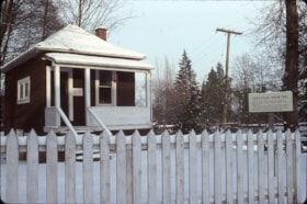
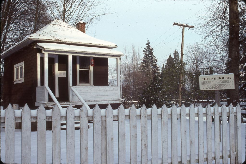
Heritage Village
https://search.heritageburnaby.ca/link/archivedescription91713
- Repository
- City of Burnaby Archives
- Date
- January 1985
- Collection/Fonds
- Doreen Lawson fonds
- Description Level
- File
- Physical Description
- 20 photographs : col. slides ; 35 mm
- Scope and Content
- File consists of photographs of Heritage Village (Burnaby Village Museum) in the snow. Buildings depicted in the photographs include: Jubilee Music store, optometrist, Electric Theatre, real estate office, Chinese Herbalist store, church, and Village blacksmith. Also included in the file are photo…
- Repository
- City of Burnaby Archives
- Date
- January 1985
- Collection/Fonds
- Doreen Lawson fonds
- Physical Description
- 20 photographs : col. slides ; 35 mm
- Description Level
- File
- Record No.
- 618-031
- Access Restriction
- No restrictions
- Reproduction Restriction
- No restrictions
- Accession Number
- 2015-15
- Scope and Content
- File consists of photographs of Heritage Village (Burnaby Village Museum) in the snow. Buildings depicted in the photographs include: Jubilee Music store, optometrist, Electric Theatre, real estate office, Chinese Herbalist store, church, and Village blacksmith. Also included in the file are photographs of the Heritage Burnaby entrance sign and donation plaque for the Japanese Bathhouse.
- Names
- Burnaby Village Museum
- Media Type
- Photograph
- Photographer
- Lawson, Doreen A.
- Notes
- Transcribed title
- Title transcribed from label on original slide cases
- Street Address
- 6501 Deer Lake Avenue
- Historic Neighbourhood
- Burnaby Lake (Historic Neighbourhood)
- Planning Study Area
- Morley-Buckingham Area
Images
3051-75 Underhill Ave
https://search.heritageburnaby.ca/link/archivedescription93744
- Repository
- City of Burnaby Archives
- Date
- 1989
- Collection/Fonds
- Grover, Elliott & Co. Ltd. fonds
- Description Level
- File
- Physical Description
- 11 photographs : col. negatives ; 35 mm
- Scope and Content
- Photographs of two industrial buildings and a residential building in Burnaby, BC.
- Repository
- City of Burnaby Archives
- Date
- 1989
- Collection/Fonds
- Grover, Elliott & Co. Ltd. fonds
- Physical Description
- 11 photographs : col. negatives ; 35 mm
- Description Level
- File
- Record No.
- 622-029
- Access Restriction
- No restrictions
- Reproduction Restriction
- No restrictions
- Accession Number
- 2017-39
- Scope and Content
- Photographs of two industrial buildings and a residential building in Burnaby, BC.
- Media Type
- Photograph
- Notes
- Transcribed title
- Title transcribed from print envelope photographs were originally housed in
- File no. 89-394-B
- Geographic Access
- Underhill Avenue
- Planning Study Area
- Lake City Area
6622 Willingdon
https://search.heritageburnaby.ca/link/archivedescription93741
- Repository
- City of Burnaby Archives
- Date
- 1989
- Collection/Fonds
- Grover, Elliott & Co. Ltd. fonds
- Description Level
- File
- Physical Description
- 14 photographs : col. negatives ; 35 mm + 3 photographs : col. ; 10 cm x 15 cm
- Scope and Content
- Photographs of the exterior of a three-storey apartment complex located at 6622 Willingdon Avenue, an unidentified industrial complex (Norland), and Heywood Park Place.
- Repository
- City of Burnaby Archives
- Date
- 1989
- Collection/Fonds
- Grover, Elliott & Co. Ltd. fonds
- Physical Description
- 14 photographs : col. negatives ; 35 mm + 3 photographs : col. ; 10 cm x 15 cm
- Description Level
- File
- Record No.
- 622-026
- Access Restriction
- No restrictions
- Reproduction Restriction
- No restrictions
- Accession Number
- 2017-39
- Scope and Content
- Photographs of the exterior of a three-storey apartment complex located at 6622 Willingdon Avenue, an unidentified industrial complex (Norland), and Heywood Park Place.
- Media Type
- Photograph
- Notes
- Transcribed title
- Title transcribed from print envelope photographs were originally housed in
- File no. 89-235-B
- Photographs 622-026-15 : 622-026-17 depict 6622 Willingdon Avenue
- Geographic Access
- Willingdon Avenue
- Street Address
- 6622 Willingdon Avenue
- Historic Neighbourhood
- Central Park (Historic Neighbourhood)
- Planning Study Area
- Maywood Area

Metrotown Station Square
https://search.heritageburnaby.ca/link/archivedescription93745
- Repository
- City of Burnaby Archives
- Date
- November 1989
- Collection/Fonds
- Grover, Elliott & Co. Ltd. fonds
- Description Level
- File
- Physical Description
- 83 photographs : col. negatives ; 35 mm + 2 computer disks ; 14 x 14 cm
- Scope and Content
- Photographs of Metrotown Station Square during construction. Businesses visible in the photographs include: Eastons, Holiday Inn, Future Shop, Great Canadian Superstore, and Toy City Consumers.
- Repository
- City of Burnaby Archives
- Date
- November 1989
- Collection/Fonds
- Grover, Elliott & Co. Ltd. fonds
- Physical Description
- 83 photographs : col. negatives ; 35 mm + 2 computer disks ; 14 x 14 cm
- Description Level
- File
- Record No.
- 622-030
- Access Restriction
- No restrictions
- Reproduction Restriction
- No restrictions
- Accession Number
- 2017-39
- Scope and Content
- Photographs of Metrotown Station Square during construction. Businesses visible in the photographs include: Eastons, Holiday Inn, Future Shop, Great Canadian Superstore, and Toy City Consumers.
- Media Type
- Photograph
- Notes
- Transcribed title
- Title transcribed from print envelopes photographs were originally housed in
- File no. 89-512-B
- Computer disks are labelled "Station Square Metro Town Nov /89". Computer disk envelopes are labelled "Suite 660-1380 Burrard ST / Van, BC"
- Geographic Access
- McKay Avenue
- Street Address
- 6200 McKay Avenue
- Historic Neighbourhood
- Central Park (Historic Neighbourhood)
- Planning Study Area
- Maywood Area
Images

SFU Residence
https://search.heritageburnaby.ca/link/archivedescription93721
- Repository
- City of Burnaby Archives
- Date
- 1989
- Collection/Fonds
- Grover, Elliott & Co. Ltd. fonds
- Description Level
- File
- Physical Description
- 25 photographs : col. negatives ; 35 mm
- Scope and Content
- Photographs of the exteriors of four Simon Fraser University (SFU) residences: Shell House, Madge Hogarth House, Louis Riel House, and McTaggart-Cowan Hall
- Repository
- City of Burnaby Archives
- Date
- 1989
- Collection/Fonds
- Grover, Elliott & Co. Ltd. fonds
- Physical Description
- 25 photographs : col. negatives ; 35 mm
- Description Level
- File
- Record No.
- 622-010
- Access Restriction
- No restrictions
- Reproduction Restriction
- No restrictions
- Accession Number
- 2017-39
- Scope and Content
- Photographs of the exteriors of four Simon Fraser University (SFU) residences: Shell House, Madge Hogarth House, Louis Riel House, and McTaggart-Cowan Hall
- Names
- Simon Fraser University
- Media Type
- Photograph
- Notes
- Transcribed title
- Title transcribed from original print envelope
- Photographs 622-010-1 : 622-010-6 depict Madge Hogarth House
- Photographs 622-010-7 : 622-010-12 depict Shell House
- Photographs 622-010-13 : 622-010-15 and 622-010-19 : 622-010-21 depict Louis Riel Hous
- Photographs 622-010-16 : 622-010-18 and 622-010-22 : 622-010-25 depict McTaggart-Cowan Hall
- Residences were identified using notes on verso of accompanying prints
- Geographic Access
- Burnaby Mountain Conservation Area
- Planning Study Area
- Burnaby Mountain Area
3000, 3100, 3200 Beta Ave
https://search.heritageburnaby.ca/link/archivedescription93739
- Repository
- City of Burnaby Archives
- Date
- 1989
- Collection/Fonds
- Grover, Elliott & Co. Ltd. fonds
- Description Level
- File
- Physical Description
- 40 photographs : col. negatives ; 35 mm
- Scope and Content
- Photographs of the commercial buildings and loading bays located at 3000, 3100, and 3200 Beta Avenue.
- Repository
- City of Burnaby Archives
- Date
- 1989
- Collection/Fonds
- Grover, Elliott & Co. Ltd. fonds
- Physical Description
- 40 photographs : col. negatives ; 35 mm
- Description Level
- File
- Record No.
- 622-024
- Access Restriction
- No restrictions
- Reproduction Restriction
- No restrictions
- Accession Number
- 2017-39
- Scope and Content
- Photographs of the commercial buildings and loading bays located at 3000, 3100, and 3200 Beta Avenue.
- Subjects
- Buildings - Commercial
- Media Type
- Photograph
- Notes
- Transcribed title
- Title transcribed from print envelope photographs were originally housed in
- File no. 89-214-B
- Geographic Access
- Beta Avenue
- Street Address
- 3000 Beta Avenue
- 3100 Beta Avenue
- 3200 Beta Avenue
- Planning Study Area
- Douglas-Gilpin Area
3650 Bonneville Place
https://search.heritageburnaby.ca/link/archivedescription93737
- Repository
- City of Burnaby Archives
- Date
- March 1989
- Collection/Fonds
- Grover, Elliott & Co. Ltd. fonds
- Description Level
- File
- Physical Description
- 8 photographs : col. ; 10 cm x 15 cm
- Scope and Content
- Photographs of the commercial complex located at 3650 Bonneville Place. Phase I of the complex is complete and Phase II is under construction. Businesses visible in the photographs include Four Seasons Greenhouses and Shaw.
- Repository
- City of Burnaby Archives
- Date
- March 1989
- Collection/Fonds
- Grover, Elliott & Co. Ltd. fonds
- Physical Description
- 8 photographs : col. ; 10 cm x 15 cm
- Description Level
- File
- Record No.
- 622-022
- Access Restriction
- No restrictions
- Reproduction Restriction
- No restrictions
- Accession Number
- 2017-39
- Scope and Content
- Photographs of the commercial complex located at 3650 Bonneville Place. Phase I of the complex is complete and Phase II is under construction. Businesses visible in the photographs include Four Seasons Greenhouses and Shaw.
- Subjects
- Buildings - Commercial
- Construction
- Media Type
- Photograph
- Notes
- Transcribed title
- Title transcribed from sticky note adhered to photograph 622-022-1
- File no. 89-124-B
- Photograph 622-022-1 captions reads: "3650 Bonneville - south view"
- Photograph 622-022-2 caption reads: "North and east facade"
- Photograph 622-022-3 caption reads: "View north along Broadway Street; Note entry bridges"
- Photograph 622-022-4 caption reads: "Southern view along Broadway Street"
- Photograph 622-022-5 caption reads: "Front facade and main entry for Phase I"
- Photograph 622-022-6 caption reads: "Rear and loading facilities for Phase I"
- Photograph 622-022-7 caption reads: "View west to Phase II from entry driveway"
- Photograph 622-022-8 caption reads: "Site preparation for Phase I
- Photograph captions transcribed from the paper on which the photographs were originally adhered.
- Geographic Access
- Bonneville Place
- Street Address
- 3650 Bonneville Place
- Planning Study Area
- Lake City Area
5499-5495 Regent Street / 2857 Douglas Road
https://search.heritageburnaby.ca/link/archivedescription93713
- Repository
- City of Burnaby Archives
- Date
- 1987
- Collection/Fonds
- Grover, Elliott & Co. Ltd. fonds
- Description Level
- File
- Physical Description
- 24 photographs : col. negatives ; 35 mm
- Scope and Content
- Photographs of the building exterior and loading bays of Loomis, located at 5499 and 5495 Regent Street, and of 2857 Douglas Road. 5499 and 5495 Regent Street are addresses that no longer exist; the current address is 5491 Regent Street.
- Repository
- City of Burnaby Archives
- Date
- 1987
- Collection/Fonds
- Grover, Elliott & Co. Ltd. fonds
- Physical Description
- 24 photographs : col. negatives ; 35 mm
- Description Level
- File
- Record No.
- 622-002
- Access Restriction
- No restrictions
- Reproduction Restriction
- No restrictions
- Accession Number
- 2017-39
- Scope and Content
- Photographs of the building exterior and loading bays of Loomis, located at 5499 and 5495 Regent Street, and of 2857 Douglas Road. 5499 and 5495 Regent Street are addresses that no longer exist; the current address is 5491 Regent Street.
- Media Type
- Photograph
- Notes
- Transcribed title
- Title transcribed from original print envelope
- File no. 87-133-B
- Geographic Access
- Douglas Road
- Regent Street
- Street Address
- 2857 Douglas Road
- 5491 Regent Street
- Historic Neighbourhood
- Burnaby Lake (Historic Neighbourhood)
- Planning Study Area
- Dawson-Delta Area
5507 to 5555 Inman Ave
https://search.heritageburnaby.ca/link/archivedescription93747
- Repository
- City of Burnaby Archives
- Date
- 1989
- Collection/Fonds
- Grover, Elliott & Co. Ltd. fonds
- Description Level
- File
- Physical Description
- 19 photographs : col. negatives ; 35 mm
- Scope and Content
- Photographs of the properties located at 5507 to 5555 Inman Avenue - addresses that no longer exist. Buildings on the properties are single-storey houses.
- Repository
- City of Burnaby Archives
- Date
- 1989
- Collection/Fonds
- Grover, Elliott & Co. Ltd. fonds
- Physical Description
- 19 photographs : col. negatives ; 35 mm
- Description Level
- File
- Record No.
- 622-032
- Access Restriction
- No restrictions
- Reproduction Restriction
- No restrictions
- Accession Number
- 2017-39
- Scope and Content
- Photographs of the properties located at 5507 to 5555 Inman Avenue - addresses that no longer exist. Buildings on the properties are single-storey houses.
- Media Type
- Photograph
- Notes
- Transcribed title
- Title transcribed from print envelope photographs were originally housed in
- File no. 89-519-B
- Geographic Access
- Inman Avenue
- Historic Neighbourhood
- Central Park (Historic Neighbourhood)
- Planning Study Area
- Garden Village Area
5516-84 Barker St.
https://search.heritageburnaby.ca/link/archivedescription93740
- Repository
- City of Burnaby Archives
- Date
- 1989
- Collection/Fonds
- Grover, Elliott & Co. Ltd. fonds
- Description Level
- File
- Physical Description
- 14 photographs : col. negatives ; 35 mm
- Scope and Content
- Photographs of Barker Avenue and the properties located at 5516-5584 Barker Avenue - addresses that no longer exist. File also contains a photograph of the Sheffield Court at Central Park condominium development being constructed. Sheffield Court is located at 5635 Patterson Avenue
- Repository
- City of Burnaby Archives
- Date
- 1989
- Collection/Fonds
- Grover, Elliott & Co. Ltd. fonds
- Physical Description
- 14 photographs : col. negatives ; 35 mm
- Description Level
- File
- Record No.
- 622-025
- Access Restriction
- No restrictions
- Reproduction Restriction
- No restrictions
- Accession Number
- 2017-39
- Scope and Content
- Photographs of Barker Avenue and the properties located at 5516-5584 Barker Avenue - addresses that no longer exist. File also contains a photograph of the Sheffield Court at Central Park condominium development being constructed. Sheffield Court is located at 5635 Patterson Avenue
- Media Type
- Photograph
- Notes
- Transcribed title
- Title transcribed from print envelope photographs were originally housed in
- File no. 89-217-B
- Geographic Access
- Barker Avenue
- Patterson Avenue
- Street Address
- 5635 Patterson Avenue
- Historic Neighbourhood
- Central Park (Historic Neighbourhood)
- Planning Study Area
- Garden Village Area
5608 to 5628 Imperial Street
https://search.heritageburnaby.ca/link/archivedescription93730
- Repository
- City of Burnaby Archives
- Date
- 1989
- Collection/Fonds
- Grover, Elliott & Co. Ltd. fonds
- Description Level
- File
- Physical Description
- 16 photographs : col. negatives ; 35 mm
- Scope and Content
- Photographs of the commerical properties located between 5608 and 5628 Imperial Street and the intersection at Imperial Street and MacPherson Avenue. Businesses visible in the photographs include Galaxie Collision, Minit-tune, and Canadian Cash and Carry Tire Centre.
- Repository
- City of Burnaby Archives
- Date
- 1989
- Collection/Fonds
- Grover, Elliott & Co. Ltd. fonds
- Physical Description
- 16 photographs : col. negatives ; 35 mm
- Description Level
- File
- Record No.
- 622-018
- Access Restriction
- No restrictions
- Reproduction Restriction
- No restrictions
- Accession Number
- 2017-39
- Scope and Content
- Photographs of the commerical properties located between 5608 and 5628 Imperial Street and the intersection at Imperial Street and MacPherson Avenue. Businesses visible in the photographs include Galaxie Collision, Minit-tune, and Canadian Cash and Carry Tire Centre.
- Media Type
- Photograph
- Photographer
- Young, J.
- Notes
- Transcribed title
- Title transcribed from original print envelope
- Geographic Access
- Imperial Street
- MacPherson Avenue
- Street Address
- 5608 Imperial Street
- 5628 Imperial Street
- Historic Neighbourhood
- Central Park (Historic Neighbourhood)
- Planning Study Area
- Windsor Area
5621 Imperial Street
https://search.heritageburnaby.ca/link/archivedescription93712
- Repository
- City of Burnaby Archives
- Date
- 1987
- Collection/Fonds
- Grover, Elliott & Co. Ltd. fonds
- Description Level
- File
- Physical Description
- 8 photographs : col. ; 10 cm x 15 cm
- Scope and Content
- Photographs of the exterior of the commerical property located at 5621 Imperial Street.
- Repository
- City of Burnaby Archives
- Date
- 1987
- Collection/Fonds
- Grover, Elliott & Co. Ltd. fonds
- Physical Description
- 8 photographs : col. ; 10 cm x 15 cm
- Description Level
- File
- Record No.
- 622-001
- Access Restriction
- No restrictions
- Reproduction Restriction
- No restrictions
- Accession Number
- 2017-39
- Scope and Content
- Photographs of the exterior of the commerical property located at 5621 Imperial Street.
- Subjects
- Buildings - Commercial
- Media Type
- Photograph
- Notes
- Transcribed title
- Title transcribed from original print envelope
- File no. 87-056-B
- Geographic Access
- Imperial Street
- Street Address
- 5621 Imperial Street
- Historic Neighbourhood
- Central Park (Historic Neighbourhood)
- Planning Study Area
- Windsor Area
5707 Sidley Street
https://search.heritageburnaby.ca/link/archivedescription93726
- Repository
- City of Burnaby Archives
- Date
- 1989
- Collection/Fonds
- Grover, Elliott & Co. Ltd. fonds
- Description Level
- File
- Physical Description
- 16 photographs : col. negatives ; 35 mm
- Scope and Content
- Photographs of the exterior of an industrial development located at 5707 Sidley Street.
- Repository
- City of Burnaby Archives
- Date
- 1989
- Collection/Fonds
- Grover, Elliott & Co. Ltd. fonds
- Physical Description
- 16 photographs : col. negatives ; 35 mm
- Description Level
- File
- Record No.
- 622-014
- Access Restriction
- No restrictions
- Reproduction Restriction
- No restrictions
- Accession Number
- 2017-39
- Scope and Content
- Photographs of the exterior of an industrial development located at 5707 Sidley Street.
- Subjects
- Buildings - Industrial
- Media Type
- Photograph
- Notes
- Transcribed title
- Title transcribed from note on verso of photograph
- Geographic Access
- Sidley Street
- Street Address
- 5707 Sidley Street
- Historic Neighbourhood
- Alta Vista (Historic Neighbourhood)
- Planning Study Area
- Clinton-Glenwood Area
6088 Cassie Avenue
https://search.heritageburnaby.ca/link/archivedescription93717
- Repository
- City of Burnaby Archives
- Date
- 1987
- Collection/Fonds
- Grover, Elliott & Co. Ltd. fonds
- Description Level
- File
- Physical Description
- 14 photographs : col. negatives ; 35 mm + 5 photographs : col. ; 10 cm x 15 cm
- Scope and Content
- Photographs of the private residence and garden located at 6088 Cassie Avenue - an address that no longer exists.
- Repository
- City of Burnaby Archives
- Date
- 1987
- Collection/Fonds
- Grover, Elliott & Co. Ltd. fonds
- Physical Description
- 14 photographs : col. negatives ; 35 mm + 5 photographs : col. ; 10 cm x 15 cm
- Description Level
- File
- Record No.
- 622-006
- Access Restriction
- No restrictions
- Reproduction Restriction
- No restrictions
- Accession Number
- 2017-39
- Scope and Content
- Photographs of the private residence and garden located at 6088 Cassie Avenue - an address that no longer exists.
- Media Type
- Photograph
- Notes
- Transcribed title
- Title transcribed from original print envelope
- File no. 87-300-B
- Geographic Access
- Cassie Avenue
- Historic Neighbourhood
- Central Park (Historic Neighbourhood)
- Planning Study Area
- Maywood Area
7018-7092 Lougheed Hwy [at] SW intersection w/ Bainbridge Ave
https://search.heritageburnaby.ca/link/archivedescription93715
- Repository
- City of Burnaby Archives
- Date
- 1987
- Collection/Fonds
- Grover, Elliott & Co. Ltd. fonds
- Description Level
- File
- Physical Description
- 17 photographs : col. ; 10 cm x 15 cm
- Scope and Content
- Photographs of the commercial properties located at 7018-7092 Lougheed Highway and the surrounding area. Photographs depict the buildings' exteriors, interiors, and roof. Also included in the file is one photograph of a map of Sechelt being marked up.
- Repository
- City of Burnaby Archives
- Date
- 1987
- Collection/Fonds
- Grover, Elliott & Co. Ltd. fonds
- Physical Description
- 17 photographs : col. ; 10 cm x 15 cm
- Description Level
- File
- Record No.
- 622-004
- Access Restriction
- No restrictions
- Reproduction Restriction
- No restrictions
- Accession Number
- 2017-39
- Scope and Content
- Photographs of the commercial properties located at 7018-7092 Lougheed Highway and the surrounding area. Photographs depict the buildings' exteriors, interiors, and roof. Also included in the file is one photograph of a map of Sechelt being marked up.
- Media Type
- Photograph
- Notes
- Transcribed title
- Title transcribed from original print envelope
- File no. 87-201-B
- Geographic Access
- Lougheed Highway
- Street Address
- 7018 Lougheed Highway
- Planning Study Area
- Government Road Area
7818 6th Street
https://search.heritageburnaby.ca/link/archivedescription93731
- Repository
- City of Burnaby Archives
- Date
- 1989
- Collection/Fonds
- Grover, Elliott & Co. Ltd. fonds
- Description Level
- File
- Physical Description
- 26 photographs : col. negatives ; 35 mm
- Scope and Content
- Photographs of the exterior of a Benjamin Moore Paints store and surrounding area. The store is located on a corner opposite Microtel and outside the store, a sign for the Skytrain Operations and Maintenance Centre is visible.
- Repository
- City of Burnaby Archives
- Date
- 1989
- Collection/Fonds
- Grover, Elliott & Co. Ltd. fonds
- Physical Description
- 26 photographs : col. negatives ; 35 mm
- Description Level
- File
- Record No.
- 622-019
- Access Restriction
- No restrictions
- Reproduction Restriction
- No restrictions
- Accession Number
- 2017-39
- Scope and Content
- Photographs of the exterior of a Benjamin Moore Paints store and surrounding area. The store is located on a corner opposite Microtel and outside the store, a sign for the Skytrain Operations and Maintenance Centre is visible.
- Media Type
- Photograph
- Notes
- Transcribed title
- Title transcribed from original print envelope
- File no. 89v-004-O
- Property address could not be confirmed at time of description.
- Geographic Access
- 6th Street
- 12th Avenue
- Street Address
- 7818 6th Street
- Historic Neighbourhood
- East Burnaby (Historic Neighbourhood)
- Planning Study Area
- Second Street Area
7973-7993 Enterprise St
https://search.heritageburnaby.ca/link/archivedescription93718
- Repository
- City of Burnaby Archives
- Date
- 1987
- Collection/Fonds
- Grover, Elliott & Co. Ltd. fonds
- Description Level
- File
- Physical Description
- 14 photographs : col. ; 10 cm x 15 cm
- Scope and Content
- Photographs of the exterior of the commercial complex located at 7973 and 7993 Enterprise Street. Businesses visible in the photographs include: Universal, Philips, Canpar, Boss Cartage, and Hercules Forwarding Ltd.
- Repository
- City of Burnaby Archives
- Date
- 1987
- Collection/Fonds
- Grover, Elliott & Co. Ltd. fonds
- Physical Description
- 14 photographs : col. ; 10 cm x 15 cm
- Description Level
- File
- Record No.
- 622-007
- Access Restriction
- No restrictions
- Reproduction Restriction
- No restrictions
- Accession Number
- 2017-39
- Scope and Content
- Photographs of the exterior of the commercial complex located at 7973 and 7993 Enterprise Street. Businesses visible in the photographs include: Universal, Philips, Canpar, Boss Cartage, and Hercules Forwarding Ltd.
- Media Type
- Photograph
- Notes
- Transcribed title
- Title transcribed from original print envelope
- File no. 87-485-B
- Geographic Access
- Enterprise Street
- Street Address
- 7973 Enterprise Street
- 7993 Enterprise Street
- Planning Study Area
- Lake City Area
8357 Tenth Avenue, 8350 and 8353 Eleventh Avenue
https://search.heritageburnaby.ca/link/archivedescription93724
- Repository
- City of Burnaby Archives
- Date
- 1989
- Collection/Fonds
- Grover, Elliott & Co. Ltd. fonds
- Description Level
- File
- Physical Description
- 24 photographs : col. negatives ; 35 mm
- Scope and Content
- Photographs of the exterior of the low-rise apartment complex located at 8357 10th Avenue and 8350 and 8353 11th Avenue and the laneway running between the buildings.
- Repository
- City of Burnaby Archives
- Date
- 1989
- Collection/Fonds
- Grover, Elliott & Co. Ltd. fonds
- Physical Description
- 24 photographs : col. negatives ; 35 mm
- Description Level
- File
- Record No.
- 622-013
- Access Restriction
- No restrictions
- Reproduction Restriction
- No restrictions
- Accession Number
- 2017-39
- Scope and Content
- Photographs of the exterior of the low-rise apartment complex located at 8357 10th Avenue and 8350 and 8353 11th Avenue and the laneway running between the buildings.
- Media Type
- Photograph
- Notes
- Transcribed title
- Title transcribed from original print envelope
- Geographic Access
- 10th Avenue
- 11th Avenue
- Street Address
- 8357 10th Avenue
- 8350 11th Avenue
- 8353 11th Avenue
- Historic Neighbourhood
- East Burnaby (Historic Neighbourhood)
- Planning Study Area
- Cariboo-Armstrong Area
8575 Government Street
https://search.heritageburnaby.ca/link/archivedescription93738
- Repository
- City of Burnaby Archives
- Date
- March 1989
- Collection/Fonds
- Grover, Elliott & Co. Ltd. fonds
- Description Level
- File
- Physical Description
- 4 photographs : col. ; 10 cm x 15 cm
- Scope and Content
- Photographs of the industrial complex located at 8575 Government Street under construction.
- Repository
- City of Burnaby Archives
- Date
- March 1989
- Collection/Fonds
- Grover, Elliott & Co. Ltd. fonds
- Physical Description
- 4 photographs : col. ; 10 cm x 15 cm
- Description Level
- File
- Record No.
- 622-023
- Access Restriction
- No restrictions
- Reproduction Restriction
- No restrictions
- Accession Number
- 2017-39
- Scope and Content
- Photographs of the industrial complex located at 8575 Government Street under construction.
- Media Type
- Photograph
- Notes
- Transcribed title
- Title transcribed from sticky note adhered to photograph 622-023-1
- File no. 89-125-B
- Photograph 622-023-1 caption reads: "View north from Government Street"
- Photograph 622-023-2 caption reads: "Eastern view along Government Street; Note Gaglardi Way overpass"
- Photograph 622-023-3 caption reads: "Rear of building"
- Photograph 622-023-4 caption reads: "Southern view along main facade"
- Photograph captions transcribed from the paper on which the photographs were originally adhered.
- Geographic Access
- Government Street
- Street Address
- 8575 Government Street
- Planning Study Area
- Lake City Area