More like 'O.G. Naud house'
Narrow Results By
Decade
- 2020s 119
- 2010s 118
- 2000s
- 1990s 641
- 1980s
- 1970s 946
- 1960s 378
- 1950s 544
- 1940s 596
- 1930s 608
- 1920s 651
- 1910s 604
- 1900s 269
- 1890s 36
- 1880s 70
- 1870s 5
- 1860s 3
- 1850s 1
- 1840s 1
- 1830s 1
- 1820s 1
- 1810s 1
- 1800s 1
- 1790s 1
- 1780s 1
- 1770s 1
- 1760s 1
- 1750s 1
- 1740s 1
- 1730s 1
- 1720s 1
- 1710s 1
- 1700s 1
- 1690s 1
- 1680s 1
- 1670s 1
- 1660s 1
- 1650s 1
- 1640s 1
- 1630s 1
- 1620s 1
- 1610s 1
- 1600s 1

Canada geese in the park
https://search.heritageburnaby.ca/link/archivedescription59046
- Repository
- City of Burnaby Archives
- Date
- ca.1983
- Collection/Fonds
- Columbian Newspaper collection
- Description Level
- Item
- Physical Description
- 1 photograph : b&w ; 17.5 x 20 cm
- Scope and Content
- Photograph of a flock of Canada geese on a grassy field in a park.
- Repository
- City of Burnaby Archives
- Date
- ca.1983
- Collection/Fonds
- Columbian Newspaper collection
- Physical Description
- 1 photograph : b&w ; 17.5 x 20 cm
- Description Level
- Item
- Record No.
- 480-1452
- Access Restriction
- No restrictions
- Reproduction Restriction
- Reproduce for fair dealing purposes only
- Accession Number
- 2009-01
- Scope and Content
- Photograph of a flock of Canada geese on a grassy field in a park.
- Subjects
- Geographic Features - Fields
- Geographic Features - Lakes and Ponds
- Geographic Features - Parks
- Animals - Birds
- Media Type
- Photograph
- Photographer
- Battistoni, Peter
- Notes
- Title based on contents of photograph
- Photographer's stamp on verso
- Note on verso reads: "page 4 / Burnaby / Today / PMT 100%"
Images

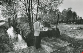
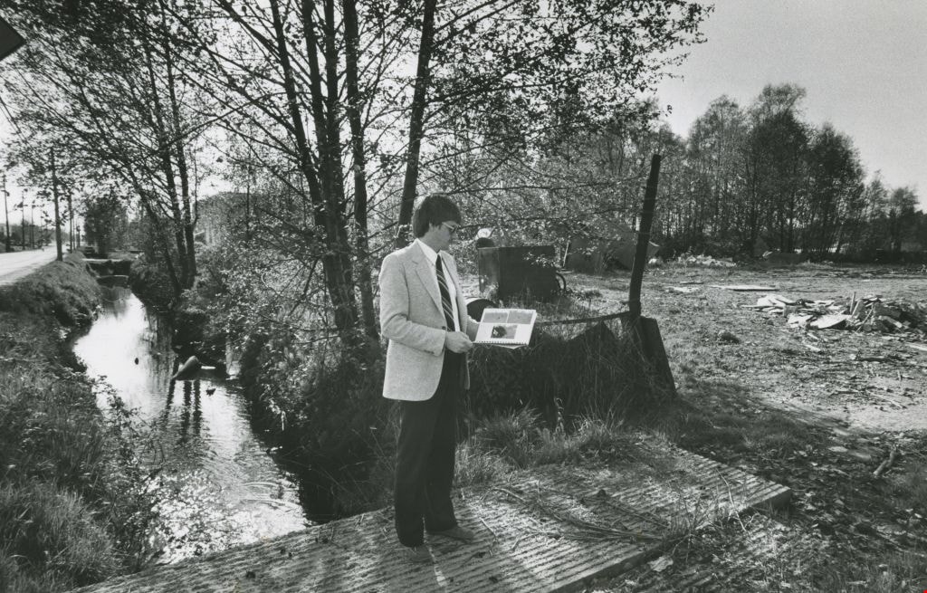
Man in the park
https://search.heritageburnaby.ca/link/archivedescription58992
- Repository
- City of Burnaby Archives
- Date
- 1983
- Collection/Fonds
- Columbian Newspaper collection
- Description Level
- Item
- Physical Description
- 1 photograph : b&w ; 18 x 25.5 cm
- Scope and Content
- Photograph of a man in a suit next to an empty lot or park. He is standing on a plank bridge over a ditch by the road that is filled with water and reviewing a book or report.
- Repository
- City of Burnaby Archives
- Date
- 1983
- Collection/Fonds
- Columbian Newspaper collection
- Physical Description
- 1 photograph : b&w ; 18 x 25.5 cm
- Description Level
- Item
- Record No.
- 480-1402
- Access Restriction
- No restrictions
- Reproduction Restriction
- Reproduce for fair dealing purposes only
- Accession Number
- 2009-01
- Scope and Content
- Photograph of a man in a suit next to an empty lot or park. He is standing on a plank bridge over a ditch by the road that is filled with water and reviewing a book or report.
- Media Type
- Photograph
- Photographer
- Battistoni, Peter
- Notes
- Title based on contents of photograph
- Photographer's stamp on verso
- Note on verso reads: "PMT 100% / page A-3 / Burnaby Today"
Images
6088 Cassie Avenue
https://search.heritageburnaby.ca/link/archivedescription93717
- Repository
- City of Burnaby Archives
- Date
- 1987
- Collection/Fonds
- Grover, Elliott & Co. Ltd. fonds
- Description Level
- File
- Physical Description
- 14 photographs : col. negatives ; 35 mm + 5 photographs : col. ; 10 cm x 15 cm
- Scope and Content
- Photographs of the private residence and garden located at 6088 Cassie Avenue - an address that no longer exists.
- Repository
- City of Burnaby Archives
- Date
- 1987
- Collection/Fonds
- Grover, Elliott & Co. Ltd. fonds
- Physical Description
- 14 photographs : col. negatives ; 35 mm + 5 photographs : col. ; 10 cm x 15 cm
- Description Level
- File
- Record No.
- 622-006
- Access Restriction
- No restrictions
- Reproduction Restriction
- No restrictions
- Accession Number
- 2017-39
- Scope and Content
- Photographs of the private residence and garden located at 6088 Cassie Avenue - an address that no longer exists.
- Media Type
- Photograph
- Notes
- Transcribed title
- Title transcribed from original print envelope
- File no. 87-300-B
- Geographic Access
- Cassie Avenue
- Historic Neighbourhood
- Central Park (Historic Neighbourhood)
- Planning Study Area
- Maywood Area
Edmonds St + 18th Ave (SW of 16th Street)
https://search.heritageburnaby.ca/link/archivedescription93727
- Repository
- City of Burnaby Archives
- Date
- March 1989
- Collection/Fonds
- Grover, Elliott & Co. Ltd. fonds
- Description Level
- File
- Physical Description
- 14 photographs : col. negatives ; 35 mm
- Scope and Content
- Photographs of the intersections at Edmonds Street and 18th Avenue and Edmonds Street and 16th Avenue and an unidentified residential lane.
- Repository
- City of Burnaby Archives
- Date
- March 1989
- Collection/Fonds
- Grover, Elliott & Co. Ltd. fonds
- Physical Description
- 14 photographs : col. negatives ; 35 mm
- Description Level
- File
- Record No.
- 622-015
- Access Restriction
- No restrictions
- Reproduction Restriction
- No restrictions
- Accession Number
- 2017-39
- Scope and Content
- Photographs of the intersections at Edmonds Street and 18th Avenue and Edmonds Street and 16th Avenue and an unidentified residential lane.
- Media Type
- Photograph
- Notes
- Transcribed title
- Title transcribed from original print envelope
- Photographs 622-015-001 : 622-015-002 depict Edmonds Street and 16th Avenue, facing south
- Photographs 622-015-003 : 622-015-004 depict the view southwest along Edmonds Street
- Photographs 622-015-006 : 622-015-008 depict the view southeast along 16th Street
- Photographs 622-015-009 : 622-015-011 depict the view southwest along 18th Avenue
- Locations were identified using notes on verso of accompanying prints
- Geographic Access
- 18th Avenue
- Edmonds Street
- 16th Avenue
- Historic Neighbourhood
- Edmonds (Historic Neighbourhood)
- Planning Study Area
- Stride Avenue Area
![SFU Terry Fox Field running track, [2001] thumbnail](/media/hpo/_Data/_Archives_Images/_Unrestricted/535/535-2847.jpg?width=280)
SFU Terry Fox Field running track
https://search.heritageburnaby.ca/link/archivedescription97508
- Repository
- City of Burnaby Archives
- Date
- [2001]
- Collection/Fonds
- Burnaby NewsLeader photograph collection
- Description Level
- Item
- Physical Description
- 1 photograph (tiff) : col.
- Scope and Content
- Photograph of an unidentified person painting the lane markers on the running track at Terry Fox Field at Simon Fraser University.
- Repository
- City of Burnaby Archives
- Date
- [2001]
- Collection/Fonds
- Burnaby NewsLeader photograph collection
- Physical Description
- 1 photograph (tiff) : col.
- Description Level
- Item
- Record No.
- 535-2847
- Access Restriction
- No restrictions
- Reproduction Restriction
- No restrictions
- Accession Number
- 2018-12
- Scope and Content
- Photograph of an unidentified person painting the lane markers on the running track at Terry Fox Field at Simon Fraser University.
- Subjects
- Geographic Features - Athletic Fields
- Buildings - Schools - Universities and Colleges
- Buildings - Recreational - Sports
- Names
- Simon Fraser University
- Media Type
- Photograph
- Photographer
- Bartel, Mario
- Notes
- Title based on caption
- Collected by editorial for use in a September 2001 issue of the Burnaby NewsLeader
- Caption from metadata: "The newly-rebuilt running track at Terry Fox Field at Simon Fraser University finally earns its stripes as a worker paints the lane markers."
- Geographic Access
- Burnaby Mountain Conservation Area
- University Drive
- Street Address
- 8888 University Drive
- Planning Study Area
- Burnaby Mountain Area
Images
![SFU Terry Fox Field running track, [2001] thumbnail](/media/hpo/_Data/_Archives_Images/_Unrestricted/535/535-2847.jpg)
![Burnaby Lake Sports Complex observation tower, [2002] thumbnail](/media/hpo/_Data/_Archives_Images/_Unrestricted/535/535-2923-1.jpg?width=280)
Burnaby Lake Sports Complex observation tower
https://search.heritageburnaby.ca/link/archivedescription97607
- Repository
- City of Burnaby Archives
- Date
- [2002]
- Collection/Fonds
- Burnaby NewsLeader photograph collection
- Description Level
- File
- Physical Description
- 2 photographs (tiff) : col.
- Scope and Content
- File contains photographs of Tom Sadler, an employee with the City of Burnaby Parks and Recreation Department, at the new and under-construction observation tower at the Burnaby Lake Sports Complex. Photographs depict Sadler looking over the fields of the Burnaby Lake Sports Complex from the tower,…
- Repository
- City of Burnaby Archives
- Date
- [2002]
- Collection/Fonds
- Burnaby NewsLeader photograph collection
- Physical Description
- 2 photographs (tiff) : col.
- Description Level
- File
- Record No.
- 535-2923
- Access Restriction
- No restrictions
- Reproduction Restriction
- No restrictions
- Accession Number
- 2018-12
- Scope and Content
- File contains photographs of Tom Sadler, an employee with the City of Burnaby Parks and Recreation Department, at the new and under-construction observation tower at the Burnaby Lake Sports Complex. Photographs depict Sadler looking over the fields of the Burnaby Lake Sports Complex from the tower, and inside the tower, demonstrating the tower's sliding windows.
- Subjects
- Buildings - Recreational - Sports
- Geographic Features - Athletic Fields
- Occupations - Civic Workers
- Media Type
- Photograph
- Photographer
- Bartel, Mario
- Notes
- Title based on caption
- Collected by editorial for use in a January 2002 issue of the Burnaby NewsLeader
- Caption from metadata for 535-2923-1: "Tom Sadler, of Burnaby's Parks and Rec Department, gets a spotter's-eye view of the playing fields at Burnaby Lake Sports Complex from the roof of the new viewing tower that is nearing completion. He says the rooftop area will be particularly useful for spotters working football games. The tower looks out over fields one and three."
- Caption from metadata for 535-2923-2: "Tom Sadler, of Burnaby's Parks and Rec Department, demonstrates how the sliding windows in the new observation tower at Burnaby Lake Sports Complex can open to give an unobstructed view to the playing fields below. The windows had to be specially imported from Germany, and allows a tv camera to be set up inside the tower, safe from the elements, and still shoot the whole field."
- Geographic Access
- Kensington Avenue
- Burnaby Lake Sports Complex
- Historic Neighbourhood
- Burnaby Lake (Historic Neighbourhood)
- Planning Study Area
- Ardingley-Sprott Area
Images
![Burnaby Lake Sports Complex observation tower, [2002] thumbnail](/media/hpo/_Data/_Archives_Images/_Unrestricted/535/535-2923-1.jpg)
![Don Brown at Bonsor, [2002] thumbnail](/media/hpo/_Data/_Archives_Images/_Unrestricted/535/535-2778.jpg?width=280)
Don Brown at Bonsor
https://search.heritageburnaby.ca/link/archivedescription97403
- Repository
- City of Burnaby Archives
- Date
- [2002]
- Collection/Fonds
- Burnaby NewsLeader photograph collection
- Description Level
- Item
- Physical Description
- 1 photograph (tiff) : col.
- Scope and Content
- Photograph of Don Brown posing against a playing field's fence. The Bonsor Recreation Complex, where the South Burnaby Metro Club is based, and neighbouring office and apartment towers are visible in the background.
- Repository
- City of Burnaby Archives
- Date
- [2002]
- Collection/Fonds
- Burnaby NewsLeader photograph collection
- Physical Description
- 1 photograph (tiff) : col.
- Description Level
- Item
- Record No.
- 535-2778
- Access Restriction
- No restrictions
- Reproduction Restriction
- No restrictions
- Accession Number
- 2018-12
- Scope and Content
- Photograph of Don Brown posing against a playing field's fence. The Bonsor Recreation Complex, where the South Burnaby Metro Club is based, and neighbouring office and apartment towers are visible in the background.
- Media Type
- Photograph
- Photographer
- Bartel, Mario
- Notes
- Title based on caption
- Collected by editorial for use in a September 2002 issue of the Burnaby NewsLeader
- Caption from metadata: "Don Brown surveys all that has grown from the South Burnaby Men's Club's initial investment of $7500 to begin acquiring properties in the heart of Burnaby in 1965. He says the playing fields and Bonsor Recreation Centre, where the South Burnaby Metro Club is now based, are "an oasis" in the densely developed Metrotown area."
- Geographic Access
- Bonsor Avenue
- Street Address
- 6550 Bonsor Avenue
- Historic Neighbourhood
- Central Park (Historic Neighbourhood)
- Planning Study Area
- Marlborough Area
Images
![Don Brown at Bonsor, [2002] thumbnail](/media/hpo/_Data/_Archives_Images/_Unrestricted/535/535-2778.jpg)
![SFU Terry Fox Run, [2001] thumbnail](/media/hpo/_Data/_Archives_Images/_Unrestricted/535/535-2849.jpg?width=280)
SFU Terry Fox Run
https://search.heritageburnaby.ca/link/archivedescription97510
- Repository
- City of Burnaby Archives
- Date
- [2001]
- Collection/Fonds
- Burnaby NewsLeader photograph collection
- Description Level
- Item
- Physical Description
- 1 photograph (tiff) : col.
- Scope and Content
- Photograph of Simon Fraser University students and staff walking on the Terry Fox Field running track, next to the SFU gymnasium, during the university's Terry Fox Run.
- Repository
- City of Burnaby Archives
- Date
- [2001]
- Collection/Fonds
- Burnaby NewsLeader photograph collection
- Physical Description
- 1 photograph (tiff) : col.
- Description Level
- Item
- Record No.
- 535-2849
- Access Restriction
- No restrictions
- Reproduction Restriction
- No restrictions
- Accession Number
- 2018-12
- Scope and Content
- Photograph of Simon Fraser University students and staff walking on the Terry Fox Field running track, next to the SFU gymnasium, during the university's Terry Fox Run.
- Subjects
- Persons - Students
- Events - Fundraising
- Buildings - Schools - Universities and Colleges
- Geographic Features - Athletic Fields
- Names
- Simon Fraser University
- Media Type
- Photograph
- Photographer
- Bartel, Mario
- Notes
- Title based on caption
- Collected by editorial for use in a September 2001 issue of the Burnaby NewsLeader
- Caption from metadata: "Students, staff and faculty at Simon Fraser University honor the spirit of Terry Fox at their own Terry Fox Run on Wednesday. The University, where Fox was a student before he embarked on his cross-country journey, also unveiled a new statue of Fox, in the Academic Quadrangle."
- Geographic Access
- Burnaby Mountain Conservation Area
- University Drive
- Street Address
- 8888 University Drive
- Planning Study Area
- Burnaby Mountain Area
Images
![SFU Terry Fox Run, [2001] thumbnail](/media/hpo/_Data/_Archives_Images/_Unrestricted/535/535-2849.jpg)
![Baldwin House, [2002] thumbnail](/media/hpo/_Data/_Archives_Images/_Unrestricted/535/535-2830-2.jpg?width=280)
Baldwin House
https://search.heritageburnaby.ca/link/archivedescription97491
- Repository
- City of Burnaby Archives
- Date
- [2002]
- Collection/Fonds
- Burnaby NewsLeader photograph collection
- Description Level
- File
- Physical Description
- 4 photographs (tiff) : col.
- Scope and Content
- File contains of photographs of Baldwin House on Deer Lake, the home designed for the Baldwins by Arthur Erickson, prior to its heritage designation by the City of Burnaby. Photographs depict Ruth Baldwin posing on the house's deck by Deer Lake; an exterior view of the home; the home's dock; and a …
- Repository
- City of Burnaby Archives
- Date
- [2002]
- Collection/Fonds
- Burnaby NewsLeader photograph collection
- Physical Description
- 4 photographs (tiff) : col.
- Description Level
- File
- Record No.
- 535-2830
- Access Restriction
- No restrictions
- Reproduction Restriction
- No restrictions
- Accession Number
- 2018-12
- Scope and Content
- File contains of photographs of Baldwin House on Deer Lake, the home designed for the Baldwins by Arthur Erickson, prior to its heritage designation by the City of Burnaby. Photographs depict Ruth Baldwin posing on the house's deck by Deer Lake; an exterior view of the home; the home's dock; and a view of the interior living room with its original drapes and Scandinavian furniture.
- Subjects
- Buildings - Heritage
- Buildings - Residential - Houses
- Geographic Features - Lakes and Ponds
- Names
- Baldwin, Ruth
- Media Type
- Photograph
- Photographer
- Bartel, Mario
- Notes
- Title based on caption
- Collected by editorial for use in an October 2002 issue of the Burnaby NewsLeader
- Caption from metadata for 535-2830-1: "Ruth Baldwin enjoys the view of Deer Lake from the lower level of the house designed for her and her husband by Arthur Erickson, an old school chum. The house is now owned by the City of Burnaby, which wants to give it a heritage designation."
- Caption from metadata for 535-2830-2: "Architect Arthur Erickson designed Baldwin House to complement its surroundings, on the southern shore of Deer Lake. But there were technical challenges, like supporting the house in the swampy soil."
- Caption from metadata for 535-2830-4: "The living room of Baldwin House is like a time capsule to the 1960's, with the original drapes and contemporary Scandanavian furniture that was in style at the time."
- Geographic Access
- Deer Lake Drive
- Deer Lake
- Street Address
- 6543 Deer Lake Drive
- Historic Neighbourhood
- Burnaby Lake (Historic Neighbourhood)
- Planning Study Area
- Morley-Buckingham Area
Images
![Baldwin House, [2002] thumbnail](/media/hpo/_Data/_Archives_Images/_Unrestricted/535/535-2830-2.jpg)
![4674 Southlawn Drive, [1989 or 1990] (date of original), copied 1991 thumbnail](/media/hpo/_Data/_Archives_Images/_Unrestricted/370/370-463.jpg?width=280)
4674 Southlawn Drive
https://search.heritageburnaby.ca/link/archivedescription37875
- Repository
- City of Burnaby Archives
- Date
- [1989 or 1990] (date of original), copied 1991
- Collection/Fonds
- Burnaby Historical Society fonds
- Description Level
- Item
- Physical Description
- 1 photograph : b&w ; 3.7 x 4.7 cm print on contact sheet 20.1 x 26.7 cm
- Scope and Content
- Photograph taken from 4674 Southlawn Drive after a snowfall, facing northwest.
- Repository
- City of Burnaby Archives
- Date
- [1989 or 1990] (date of original), copied 1991
- Collection/Fonds
- Burnaby Historical Society fonds
- Subseries
- Burnaby Image Bank subseries
- Physical Description
- 1 photograph : b&w ; 3.7 x 4.7 cm print on contact sheet 20.1 x 26.7 cm
- Description Level
- Item
- Record No.
- 370-463
- Access Restriction
- No restrictions
- Reproduction Restriction
- No restrictions
- Accession Number
- BHS1999-03
- Scope and Content
- Photograph taken from 4674 Southlawn Drive after a snowfall, facing northwest.
- Media Type
- Photograph
- Notes
- Title based on contents of photograph
- 1 b&w copy negative accompanying
- Negative has a pink cast
- Copied from col. photograph
- Geographic Access
- Southlawn Drive
- Planning Study Area
- Brentwood Area
Images
![4674 Southlawn Drive, [1989 or 1990] (date of original), copied 1991 thumbnail](/media/hpo/_Data/_Archives_Images/_Unrestricted/370/370-463.jpg)
![Herman Peterson, [2000] thumbnail](/media/hpo/_Data/_Archives_Images/_Unrestricted/535/535-2706.jpg?width=280)
Herman Peterson
https://search.heritageburnaby.ca/link/archivedescription97310
- Repository
- City of Burnaby Archives
- Date
- [2000]
- Collection/Fonds
- Burnaby NewsLeader photograph collection
- Description Level
- Item
- Physical Description
- 1 photograph (tiff) : col.
- Scope and Content
- Photograph of Herman Peterson posing with a handheld video camera in front of a residential home.
- Repository
- City of Burnaby Archives
- Date
- [2000]
- Collection/Fonds
- Burnaby NewsLeader photograph collection
- Physical Description
- 1 photograph (tiff) : col.
- Description Level
- Item
- Record No.
- 535-2706
- Access Restriction
- No restrictions
- Reproduction Restriction
- Reproduce for fair dealing purposes only
- Accession Number
- 2018-12
- Scope and Content
- Photograph of Herman Peterson posing with a handheld video camera in front of a residential home.
- Media Type
- Photograph
- Photographer
- Bartel, Mario
- Notes
- Title based on caption
- Collected by editorial for use in a September 2000 issue of the Burnaby NewsLeader
- Caption from metadata: "Herman Peterson used his video camera to tape the comings and goings of a suspected crack house in his neighborhood, helping police take steps to shut it down."
Images
![Herman Peterson, [2000] thumbnail](/media/hpo/_Data/_Archives_Images/_Unrestricted/535/535-2706.jpg)

Looking south from 5496 Dominion Street
https://search.heritageburnaby.ca/link/archivedescription91863
- Repository
- City of Burnaby Archives
- Date
- September 1984
- Collection/Fonds
- Small family fonds
- Description Level
- Item
- Physical Description
- 1 photograph : col. ; 10 cm x 15 cm
- Scope and Content
- Photograph of the backyard at 5496 Dominion Street. Beyond the fence, the double garage built at 5495 Norfolk Street (right) and the original house at 5511 Norfolk Street (left) are visible. The photograph was taken from 5496 Dominion Street, looking south.
- Repository
- City of Burnaby Archives
- Date
- September 1984
- Collection/Fonds
- Small family fonds
- Physical Description
- 1 photograph : col. ; 10 cm x 15 cm
- Description Level
- Item
- Record No.
- 620-044
- Access Restriction
- No restrictions
- Reproduction Restriction
- No reproduction permitted
- Accession Number
- 2017-01
- Scope and Content
- Photograph of the backyard at 5496 Dominion Street. Beyond the fence, the double garage built at 5495 Norfolk Street (right) and the original house at 5511 Norfolk Street (left) are visible. The photograph was taken from 5496 Dominion Street, looking south.
- Media Type
- Photograph
- Notes
- Transcribed title
- Title transcribed from donor's notes
- Note in blue ink on verso of photograph reads: "P7"
- Note in black ink on verso of photograph reads: "5496 Dominion St. / Burnaby, B.C. / Sept. 1984"
- 5495 Norfolk Street was previously numbered 3155 Norfolk Street. The property was later subdivided into two lots: 5491 and 5497 Norfolk Street.
- 5511 Norfolk Street was previously numbered 3149 Norfolk Street. The property was later subdivided into two lots: 5503 and 5521 Norfolk Street.
- Street Address
- 5495 Norfolk Street
- 5496 Dominion Street
- 5511 Norfolk Street
- Historic Neighbourhood
- Burnaby Lake (Historic Neighbourhood)
- Planning Study Area
- Ardingley-Sprott Area
Images


Looking south from 5496 Dominion Street
https://search.heritageburnaby.ca/link/archivedescription91864
- Repository
- City of Burnaby Archives
- Date
- July 1989
- Collection/Fonds
- Small family fonds
- Description Level
- Item
- Physical Description
- 1 photograph : col. ; 10 cm x 15 cm
- Scope and Content
- Photograph of the backyard at 5496 Dominion Street. The backyard landscaping includes a cement pathway and vegetable garden. The photograph was taken from 5496 Dominion Street, looking south.
- Repository
- City of Burnaby Archives
- Date
- July 1989
- Collection/Fonds
- Small family fonds
- Physical Description
- 1 photograph : col. ; 10 cm x 15 cm
- Description Level
- Item
- Record No.
- 620-045
- Access Restriction
- No restrictions
- Reproduction Restriction
- No reproduction permitted
- Accession Number
- 2017-01
- Scope and Content
- Photograph of the backyard at 5496 Dominion Street. The backyard landscaping includes a cement pathway and vegetable garden. The photograph was taken from 5496 Dominion Street, looking south.
- Media Type
- Photograph
- Notes
- Transcribed title
- Title transcribed from donor's notes
- Note in blue ink on verso of photograph reads: "P8"
- Note in black ink on verso of photograph reads: "July 1989"
- Street Address
- 5496 Dominion Street
- Historic Neighbourhood
- Burnaby Lake (Historic Neighbourhood)
- Planning Study Area
- Ardingley-Sprott Area
Images


Venables Street
https://search.heritageburnaby.ca/link/archivedescription52845
- Repository
- City of Burnaby Archives
- Date
- 1981
- Collection/Fonds
- Harold H. Johnston fonds
- Description Level
- Item
- Physical Description
- 1 photograph (jpeg) : b&w
- Scope and Content
- Photograph of a woman standing next to two children on a tricycle on Venables Street. A man is on the far right standing next to a parked car. Three of the people in the photograph are identified by first name only as Sharron, Andrea and Frank. The photograph was most likely taken near the Johnston…
- Repository
- City of Burnaby Archives
- Date
- 1981
- Collection/Fonds
- Harold H. Johnston fonds
- Physical Description
- 1 photograph (jpeg) : b&w
- Description Level
- Item
- Record No.
- 483-102
- Access Restriction
- No restrictions
- Reproduction Restriction
- No reproduction permitted
- Accession Number
- 2008-08
- Scope and Content
- Photograph of a woman standing next to two children on a tricycle on Venables Street. A man is on the far right standing next to a parked car. Three of the people in the photograph are identified by first name only as Sharron, Andrea and Frank. The photograph was most likely taken near the Johnston family home at 4447 Venables Street.
- Subjects
- Transportation - Automobiles
- Transportation - Bicycles
- Buildings - Residential - Houses
- Geographic Features - Roads
- Media Type
- Photograph
- Photographer
- Johnston, Harold H.
- Notes
- Title based on contents of photograph
- Geographic Access
- Venables Street
- Historic Neighbourhood
- Vancouver Heights (Historic Neighbourhood)
- Planning Study Area
- Willingdon Heights Area
Images

![Burnaby Central track, [2001] thumbnail](/media/hpo/_Data/_Archives_Images/_Unrestricted/535/535-1631.jpg?width=280)
Burnaby Central track
https://search.heritageburnaby.ca/link/archivedescription95806
- Repository
- City of Burnaby Archives
- Date
- [2001]
- Collection/Fonds
- Burnaby NewsLeader photograph collection
- Description Level
- Item
- Physical Description
- 1 photograph (tiff) : col.
- Scope and Content
- Photograph of a person in cold weather outdoor gear speedwalking along the track in front of Burnaby Central Secondary School.
- Repository
- City of Burnaby Archives
- Date
- [2001]
- Collection/Fonds
- Burnaby NewsLeader photograph collection
- Physical Description
- 1 photograph (tiff) : col.
- Description Level
- Item
- Record No.
- 535-1631
- Access Restriction
- No restrictions
- Reproduction Restriction
- No restrictions
- Accession Number
- 2018-12
- Scope and Content
- Photograph of a person in cold weather outdoor gear speedwalking along the track in front of Burnaby Central Secondary School.
- Media Type
- Photograph
- Photographer
- Bartel, Mario
- Notes
- Title based on caption
- Collected by editorial for use in a February 2001 issue of the Burnaby NewsLeader
- Caption from metadata: "The track at Burnaby Central Secondary School is a popular destination for joggers, runners and speedwalkers working out on a Saturday morning."
- Geographic Access
- Canada Way
- Street Address
- 4939 Canada Way
- Historic Neighbourhood
- Burnaby Lake (Historic Neighbourhood)
- Planning Study Area
- Douglas-Gilpin Area
Images
![Burnaby Central track, [2001] thumbnail](/media/hpo/_Data/_Archives_Images/_Unrestricted/535/535-1631.jpg)
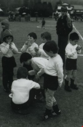
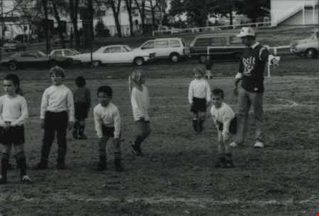
Cliff Avenue playoffs
https://search.heritageburnaby.ca/link/archivedescription38205
- Repository
- City of Burnaby Archives
- Date
- March 5, 1988 (date of original), copied 1991
- Collection/Fonds
- Burnaby Historical Society fonds
- Description Level
- Item
- Physical Description
- 1 photograph : b&w ; 4.6 x 3.0 cm print on contact sheet 20.3 x 26.6 cm
- Scope and Content
- Photograph of the Cliff Avenue soccer playoffs. The Aztecs team are shown at half time: Liam, Adam, Jason F., Marvin, Josh, Morgan, and Jonathan. Leanne F. and Jim Owen are in the background.
- Repository
- City of Burnaby Archives
- Date
- March 5, 1988 (date of original), copied 1991
- Collection/Fonds
- Burnaby Historical Society fonds
- Subseries
- Burnaby Image Bank subseries
- Physical Description
- 1 photograph : b&w ; 4.6 x 3.0 cm print on contact sheet 20.3 x 26.6 cm
- Description Level
- Item
- Record No.
- 370-792
- Access Restriction
- No restrictions
- Reproduction Restriction
- No restrictions
- Accession Number
- BHS1999-03
- Scope and Content
- Photograph of the Cliff Avenue soccer playoffs. The Aztecs team are shown at half time: Liam, Adam, Jason F., Marvin, Josh, Morgan, and Jonathan. Leanne F. and Jim Owen are in the background.
- Names
- Owen, Jim
- Media Type
- Photograph
- Notes
- Title based on contents of photograph
- 1 b&w copy negative accompanying
- Copied from col. photograph
- Historic Neighbourhood
- Capitol Hill (Historic Neighbourhood)
- Planning Study Area
- Capitol Hill Area
Images

![Development on Big Bend agricultural land, [2000] thumbnail](/media/hpo/_Data/_Archives_Images/_Unrestricted/535/535-1685-2.jpg?width=280)
Development on Big Bend agricultural land
https://search.heritageburnaby.ca/link/archivedescription95885
- Repository
- City of Burnaby Archives
- Date
- [2000]
- Collection/Fonds
- Burnaby NewsLeader photograph collection
- Description Level
- File
- Physical Description
- 2 photographs (tiff) : col.
- Scope and Content
- File contains photographs of Burnaby citizens concerned about industrial and big box retail development in the Big Bend area. One photograph shows Shawn Wade leaning against a fence next to a sign that reads "Western Garden Soil Mushroom Manure Bark Mulch." The other photograph shows Ed Leong holdi…
- Repository
- City of Burnaby Archives
- Date
- [2000]
- Collection/Fonds
- Burnaby NewsLeader photograph collection
- Physical Description
- 2 photographs (tiff) : col.
- Description Level
- File
- Record No.
- 535-1685
- Access Restriction
- No restrictions
- Reproduction Restriction
- No restrictions
- Accession Number
- 2018-12
- Scope and Content
- File contains photographs of Burnaby citizens concerned about industrial and big box retail development in the Big Bend area. One photograph shows Shawn Wade leaning against a fence next to a sign that reads "Western Garden Soil Mushroom Manure Bark Mulch." The other photograph shows Ed Leong holding soil in the fields at Leong's Nursery.
- Media Type
- Photograph
- Photographer
- Bartel, Mario
- Notes
- Title based on caption
- Collected by editorial for use in a November 2000 issue of the Burnaby NewsLeader
- Caption from metadata for 535-1685-1: "Shawn Wade is concerned the City of Burnaby's plans to allow big box retail development in the Big Bend area along Marine Way would threaten the unique agricultural flavor of the area, including nurseries, and the allotment gardens."
- Caption from metadata for 535-1685-2: "Ed Leong, who's run Leong's Nursery since the 1960s, says industrial development in the Big Bend area has already destroyed his ability to grow crops like Chinese vegetables, green onions, lettuce and carrots, as water gets trapped in the already boggy soil by surrounding landfill."
- Historic Neighbourhood
- Fraser Arm (Historic Neighbourhood)
- Planning Study Area
- Big Bend Area
Images
![Development on Big Bend agricultural land, [2000] thumbnail](/media/hpo/_Data/_Archives_Images/_Unrestricted/535/535-1685-2.jpg)
![John Yanko in Kelliher, [198-] thumbnail](/media/hpo/_Data/_Archives_Images/_Unrestricted/540/545-245.jpg?width=280)
John Yanko in Kelliher
https://search.heritageburnaby.ca/link/archivedescription79773
- Repository
- City of Burnaby Archives
- Date
- [198-]
- Collection/Fonds
- Yanko family fonds
- Description Level
- Item
- Physical Description
- 1 photograph : col. ; 12 x 17.5 cm
- Scope and Content
- Photograph of John Ivan Yanko standing alone in a field in Kelliher, Saskatchewan.
- Repository
- City of Burnaby Archives
- Date
- [198-]
- Collection/Fonds
- Yanko family fonds
- Physical Description
- 1 photograph : col. ; 12 x 17.5 cm
- Material Details
- Secured to album page with photo corners
- Description Level
- Item
- Record No.
- 545-245
- Access Restriction
- No restrictions
- Reproduction Restriction
- No restrictions
- Accession Number
- 2012-09
- Scope and Content
- Photograph of John Ivan Yanko standing alone in a field in Kelliher, Saskatchewan.
- Subjects
- Geographic Features - Fields
- Names
- Yanko, John Ivan
- Media Type
- Photograph
- Notes
- Title based on contents of photograph
- Note written on album page reads: "Kelliher"
Images
![John Yanko in Kelliher, [198-] thumbnail](/media/hpo/_Data/_Archives_Images/_Unrestricted/540/545-245.jpg)
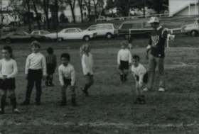
Soccer game at Capitol Hill
https://search.heritageburnaby.ca/link/archivedescription38204
- Repository
- City of Burnaby Archives
- Date
- September 26, 1987 (date of original), copied 1991
- Collection/Fonds
- Burnaby Historical Society fonds
- Description Level
- Item
- Physical Description
- 1 photograph : b&w ; 3.3 x 4.9 cm print on contact sheet 20.3 x 26.6 cm
- Scope and Content
- Photograph of children playing the first soccer game of the season at Capitol Hill, the Aztecs (in white shirts) vs. the Timbers. Left to right: Ryan, Jonathan, Marvin, Tiffany, Jason Foxon, and Morgan. The coach is Chris Foxon. Cars can be seen in the background.
- Repository
- City of Burnaby Archives
- Date
- September 26, 1987 (date of original), copied 1991
- Collection/Fonds
- Burnaby Historical Society fonds
- Subseries
- Burnaby Image Bank subseries
- Physical Description
- 1 photograph : b&w ; 3.3 x 4.9 cm print on contact sheet 20.3 x 26.6 cm
- Description Level
- Item
- Record No.
- 370-791
- Access Restriction
- No restrictions
- Reproduction Restriction
- No restrictions
- Accession Number
- BHS1999-03
- Scope and Content
- Photograph of children playing the first soccer game of the season at Capitol Hill, the Aztecs (in white shirts) vs. the Timbers. Left to right: Ryan, Jonathan, Marvin, Tiffany, Jason Foxon, and Morgan. The coach is Chris Foxon. Cars can be seen in the background.
- Names
- Foxon, Chris
- Foxon, Jason
- Media Type
- Photograph
- Notes
- Title based on contents of photograph
- 1 b&w copy negative accompanying
- Copied from col. photograph
- Historic Neighbourhood
- Capitol Hill (Historic Neighbourhood)
- Planning Study Area
- Capitol Hill Area
Images
![3700 block of Hastings Street, [2000] thumbnail](/media/hpo/_Data/_Archives_Images/_Unrestricted/535/535-3066.jpg?width=280)
3700 block of Hastings Street
https://search.heritageburnaby.ca/link/archivedescription97940
- Repository
- City of Burnaby Archives
- Date
- [2000]
- Collection/Fonds
- Burnaby NewsLeader photograph collection
- Description Level
- Item
- Physical Description
- 1 photograph (tiff) : b&w
- Scope and Content
- Photograph of the 3700 block of Hastings Street in North Burnaby, looking southeast. Kato Japanese Chinese Restaurant is one of the visible businesses and some snow is on the ground.
- Repository
- City of Burnaby Archives
- Date
- [2000]
- Collection/Fonds
- Burnaby NewsLeader photograph collection
- Physical Description
- 1 photograph (tiff) : b&w
- Description Level
- Item
- Record No.
- 535-3066
- Access Restriction
- No restrictions
- Reproduction Restriction
- No restrictions
- Accession Number
- 2018-12
- Scope and Content
- Photograph of the 3700 block of Hastings Street in North Burnaby, looking southeast. Kato Japanese Chinese Restaurant is one of the visible businesses and some snow is on the ground.
- Subjects
- Geographic Features - Roads
- Buildings - Commercial
- Buildings - Commercial - Restaurants
- Buildings - Residential
- Media Type
- Photograph
- Notes
- Title based on contents of photograph
- Collected by editorial for use in a January 2000 issue of the Burnaby NewsLeader
- Geographic Access
- Hastings Street
- Street Address
- 3700 Hastings Street
- Historic Neighbourhood
- Vancouver Heights (Historic Neighbourhood)
- Planning Study Area
- Burnaby Heights Area
Images
![3700 block of Hastings Street, [2000] thumbnail](/media/hpo/_Data/_Archives_Images/_Unrestricted/535/535-3066.jpg)