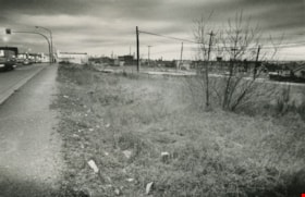
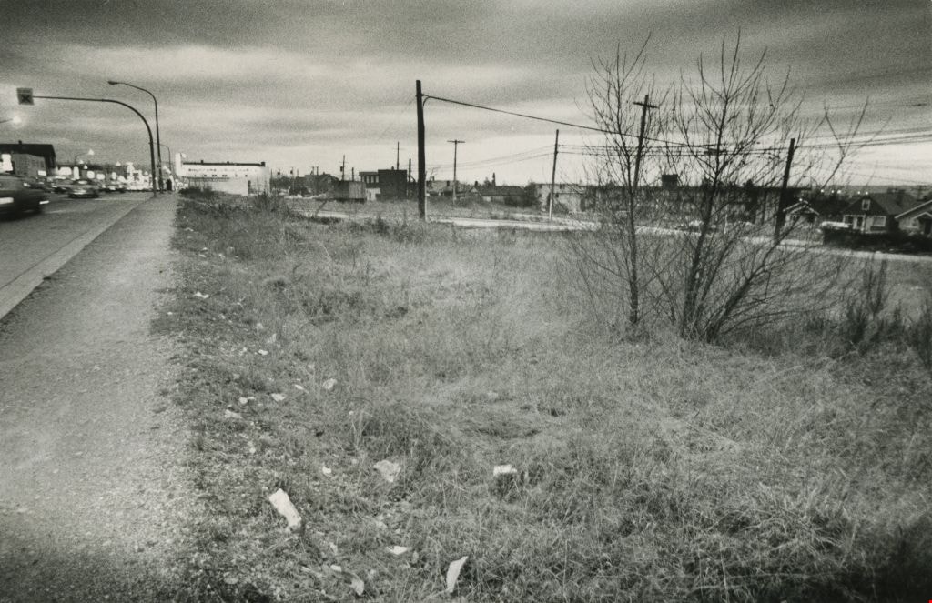
Vacant land
https://search.heritageburnaby.ca/link/archivedescription45418
- Repository
- City of Burnaby Archives
- Date
- February 1977
- Collection/Fonds
- Columbian Newspaper collection
- Description Level
- Item
- Physical Description
- 1 photograph : b&w ; 9 x 14 cm
- Scope and Content
- Photograph of vacant land, believed to be the 3900 block of Hastings, owned by the municipality.
- Repository
- City of Burnaby Archives
- Date
- February 1977
- Collection/Fonds
- Columbian Newspaper collection
- Physical Description
- 1 photograph : b&w ; 9 x 14 cm
- Description Level
- Item
- Record No.
- 480-313
- Access Restriction
- No restrictions
- Reproduction Restriction
- No restrictions
- Accession Number
- 2003-02
- Scope and Content
- Photograph of vacant land, believed to be the 3900 block of Hastings, owned by the municipality.
- Media Type
- Photograph
- Photographer
- Battistoni, Peter
- Notes
- Title based on contents of photograph
- Geographic Access
- Hastings Street
- Historic Neighbourhood
- Vancouver Heights (Historic Neighbourhood)
- Planning Study Area
- Burnaby Heights Area
Images
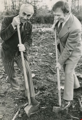
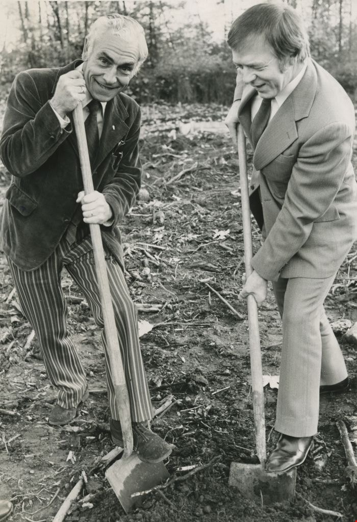
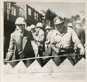
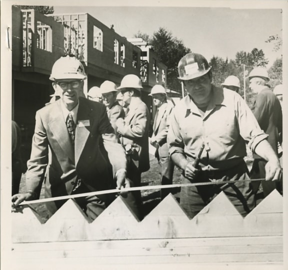
Tony Schmand with Mayor Tom Constable
https://search.heritageburnaby.ca/link/archivedescription45992
- Repository
- City of Burnaby Archives
- Date
- October 1973
- Collection/Fonds
- Columbian Newspaper collection
- Description Level
- Item
- Physical Description
- 1 photograph : b&w ; 20.5 x 14 cm
- Scope and Content
- Photograph of British Columbia Association for the Mentally Retarded president Tony Schmand with Mayor Tom Constable performing the sod turning ceremony for the site of a facility to accomodate the developmentally challenged in Burnaby.
- Repository
- City of Burnaby Archives
- Date
- October 1973
- Collection/Fonds
- Columbian Newspaper collection
- Physical Description
- 1 photograph : b&w ; 20.5 x 14 cm
- Description Level
- Item
- Record No.
- 480-887
- Access Restriction
- No restrictions
- Reproduction Restriction
- Reproduce for fair dealing purposes only
- Accession Number
- 2003-02
- Scope and Content
- Photograph of British Columbia Association for the Mentally Retarded president Tony Schmand with Mayor Tom Constable performing the sod turning ceremony for the site of a facility to accomodate the developmentally challenged in Burnaby.
- Subjects
- Land Clearing
- Ceremonies
- Media Type
- Photograph
- Photographer
- Battistoni, Peter
- Notes
- Title based on contents of photograph
- Geographic Access
- Banff Avenue
Images

Widening of Scott Road
https://search.heritageburnaby.ca/link/archivedescription56677
- Repository
- City of Burnaby Archives
- Date
- March 1976, published March 24, 1976
- Collection/Fonds
- Columbian Newspaper collection
- Description Level
- Item
- Physical Description
- 1 photograph : b&w ; 7.5 x 14 cm
- Scope and Content
- Photograph of the process of widening Scott Road in Surrey BC. The process was undertaken by the provincial government. Citizens were upset as this process included cutting down century-old trees (stumps of these former trees are visible in this photograph).
- Repository
- City of Burnaby Archives
- Date
- March 1976, published March 24, 1976
- Collection/Fonds
- Columbian Newspaper collection
- Physical Description
- 1 photograph : b&w ; 7.5 x 14 cm
- Description Level
- Item
- Record No.
- 480-531
- Access Restriction
- No restrictions
- Reproduction Restriction
- No restrictions
- Accession Number
- 2003-02
- Scope and Content
- Photograph of the process of widening Scott Road in Surrey BC. The process was undertaken by the provincial government. Citizens were upset as this process included cutting down century-old trees (stumps of these former trees are visible in this photograph).
- Media Type
- Photograph
- Photographer
- King, Basil
- Notes
- Title based on contents of photograph
- Newspaper clipping attached to verso of photograph reads: "Road-widening on Scott Rd. in Surrey has taken its toll of old trees."
Images

Baldwin family subseries
https://search.heritageburnaby.ca/link/archivedescription65666
- Repository
- City of Burnaby Archives
- Date
- 1964-2002
- Collection/Fonds
- Burnaby Historical Society fonds
- Description Level
- Subseries
- Physical Description
- Textual records and photographs
- Scope and Content
- Subseries consist of records pertaining to the Baldwin family home. Included in the fonds are newspaper clippings, magazine articles, and photographs of the house taken by Basil King.
- Repository
- City of Burnaby Archives
- Date
- 1964-2002
- Collection/Fonds
- Burnaby Historical Society fonds
- Subseries
- Baldwin family subseries
- Physical Description
- Textual records and photographs
- Description Level
- Subseries
- Accession Number
- BHS1998-03
- Scope and Content
- Subseries consist of records pertaining to the Baldwin family home. Included in the fonds are newspaper clippings, magazine articles, and photographs of the house taken by Basil King.
- History
- In 1959 Dr. William "Bill" Baldwin (d. 1987) and his wife Ruth (d. 2009) bought a cottage and approximately two and a half acres of land on the shores of Deer Lake for $16,000. The cottage and land had been owned by one of Dr. Baldwin’s colleagues at Burnaby Hospital. The couple lived in the cottage with their two young children John (b.1958) and Susan (b.1959) for a few years before deciding to renovate and expand their home. William was close friends with Arthur Erickson, the two having gone to Prince of Wales High School and McGill University together. Ruth decided that they needed a lakeshore home rather than a renovation on their cottage and Arthur Erickson would be the man to design it. Local builder Torstein Kravik completed the house in 1965. The home is considered an early example of Erickson’s design aesthetic, demonstrating his vision of "site, light and cadence." It is thought to be the best example of West Coast contemporary architecture in Burnaby. In 2001, at the age of seventy-eight, Ruth approached the City of Burnaby about buying the property,on the condition that the house be protected and that Ruth could continue to rent the home. The City purchased it and gave it Heritage designation. As of 2010, the Baldwin home and garden is on lease to The Land Conservancy of BC (TLC) to serve as a “guest house.” It is available for lease to local residents and visitors for overnight stays.
- Media Type
- Photograph
- Textual Record
- Creator
- Baldwin, Ruth
- Notes
- Title based on contents of subseries
- Photo catalogue 357, MSS145
Small family fonds
https://search.heritageburnaby.ca/link/archivedescription91819
- Repository
- City of Burnaby Archives
- Date
- 1922-2016
- Collection/Fonds
- Small family fonds
- Description Level
- Fonds
- Physical Description
- 75 photographs : b&w & col. + 1 plan
- Scope and Content
- Fonds consists of photographs documenting the transformation of the Burnaby Lake area of Burnaby, B.C. from semi-rural in the 1920s to urbanized in 2016. Photographs depict the land and houses located on the corner of Douglas Road and Dominion Street as the property was rezoned and its density quad…
- Repository
- City of Burnaby Archives
- Date
- 1922-2016
- Collection/Fonds
- Small family fonds
- Physical Description
- 75 photographs : b&w & col. + 1 plan
- Description Level
- Fonds
- Access Restriction
- Open access
- Reproduction Restriction
- May be restricted by third party rights
- Accession Number
- 2017-01
- Scope and Content
- Fonds consists of photographs documenting the transformation of the Burnaby Lake area of Burnaby, B.C. from semi-rural in the 1920s to urbanized in 2016. Photographs depict the land and houses located on the corner of Douglas Road and Dominion Street as the property was rezoned and its density quadrupled. Fonds also includes photographs of the Small family house being moved to 5496 Dominion Street and the original landscape plan for 5118 Douglas Road.
- History
- In 1915, John W. Roberts and his wife Mary Allen Roberts moved from the United States to Canada along with their daughter, Lauretta. On first moving to Canada, the family lived in a rented house in Vancouver and John worked as a movie projectionist in the city. The couple had three more children, all sons: John A., Edward, and Roland. Circa 1921, John purchased a large parcel of land at the corner of Douglas Road and Dominion Street in Burnaby. This parcel encompassed the equivalent of at least six 66-foot lots along the south side of Dominion Street and the same along the north side of Norfolk Street. On their property, a barn and small living quarters were built. The family moved in, raising goats and growing potatoes to supplement their income. They also planted cherry, apple, and pear trees; hazelnut and walnut trees; raspberries; and a large vegetable garden, the fruits of which Mary preserved for year-round use. At this time, agricultural activities were common for families in the area: the Roberts' neighbours kept chickens for personal use and for selling eggs; grew mushrooms for commercial sale; and sold manure from an old buckboard drawn by Clydesdale horses. John built a new house in the middle of the Roberts’ lots on the southwest corner of Douglas Road and Dominion Street. The house faced Douglas Road and overlooked a large, well-landscaped front yard to the east and a full-sized, clay tennis court to the north. The family moved into this new house in 1925. When the Roberts ceased raising goats, the barn and original living quarters were reduced to a double-car garage with storage space plus a sawdust-insulated “root cellar”. John also built a house on the northwest corner of the lot at Douglas Road and Dominion Street (3093 Douglas Road), which was purchased by the Hardy family. In 1957, part of this property (3071 Douglas Road) was sold to the Brocklebanks who built a house and lived there. In addition, John built a house at the northwest corner of Douglas Road and Norfolk Street (5106 Douglas Road). The original purchaser of this house is unknown, but in 1949, it was bought by the Meyers family. In 1952 or 1953, the Meyers sold part of this property and the Manahans built a house on it, facing Douglas Road. Several other lots that John owned were also sold off over the years. By the 1950s, John owned only five 66-foot lots from Douglas Road west, along the south side Dominion Street. In 1954, John sold the lot furthest from Douglas Road (5486 Dominion Street) to a builder who built a “ranch-style” house and put it up for sale. John retired from his career as a movie projectionist in the 1950s. He, Mary, and Lauretta retained their US citizenship all their lives, although they never returned to the USA except for brief visits. John A., Edward, and Roland who, as children of US citizens, also had US citizenship, eventually moved to the US, where they remained for the rest of their lives. In 1945, Lauretta married Frederick Small. The couple lived in a rented house in Vancouver for a few years before moving in with John and Mary in Burnaby. The couple had four children: Elizabeth, Kathryn, Charles, and Martin. In 1955, Frederick purchased the rancher at 5486 Dominion Street and the family moved in. The Small children grew up enjoying the freedom of having their grandparent’s large property in addition to their parent’s yard to play in. The back lane that ran between Dominion Street and Norfolk Street was filled with trees and bushes, creating a narrow bit of “forest” to explore. In 1957, John died. Mary died in 1969, as did Frederick. Lauretta was executor for her mother’s and husband’s estates. After much consideration, she decided to sell the house at 5486 Dominion Street and move back into her childhood home. By doing so, she was able to settle her mother’s estate to the satisfaction of her brothers. Elizabeth married and moved away. Over the next few years, the “Roberts” house was home to Lauretta, Kathryn, Charles, and Martin, with the three grown children moving in and out several times during the 1970s. In 1981, Lauretta died. Her children discussed at length how to divide up the property, which consisted of four 66-foot lots, according to her will. None of her children wanted to see the old family house destroyed but the house straddled two lots. They finally decided that if one of them wanted to pay to move the house to sit on one of the lots, the “value” of the house would not enter into the settlement of the estate. Kathryn chose to do this. In 1982, the old house was moved to 5496 Dominion Street and Kathryn continued to live in it. Martin died in 1982. Elizabeth and Charles each inherited one lot and the last lot, which would have gone to Martin, was sold, the funds divided equally between Elizabeth, Kathryn, and Charles. The three lots between 5496 Dominion Street and Douglas Road were subdivided into 33-foot lots and six new houses were built. In 1993, the Meyers property and the Manahan property were subdivided into 33-foot lots facing Norfolk Street and the old houses were torn down and four new houses were built.
- Media Type
- Photograph
- Technical Drawing
- Creator
- Small family
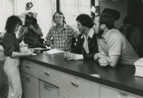
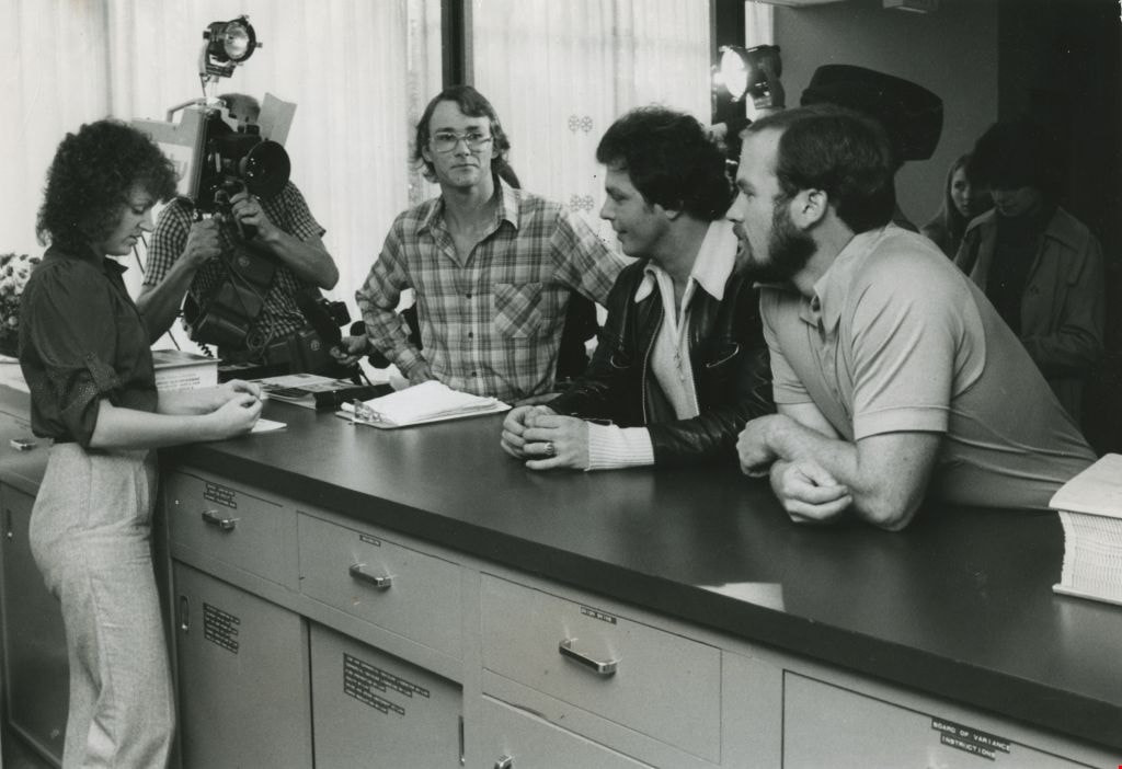
Students wait for Mayor to protest expropriation
https://search.heritageburnaby.ca/link/archivedescription45394
- Repository
- City of Burnaby Archives
- Date
- 1979
- Collection/Fonds
- Columbian Newspaper collection
- Description Level
- Item
- Physical Description
- 1 photograph : b&w ; 16.5 x 14 cm
- Scope and Content
- Photograph of University of British Columbia students L. Eric Sorensen, Nick Moldovan and Bill Buckler standing at the front desk in City Hall waiting to speak to Mayor Tom Constable. The students wished to protest the expropriation of Lillian Mann's property at 9637 Cameron Street.
- Repository
- City of Burnaby Archives
- Date
- 1979
- Collection/Fonds
- Columbian Newspaper collection
- Physical Description
- 1 photograph : b&w ; 16.5 x 14 cm
- Description Level
- Item
- Record No.
- 480-289
- Access Restriction
- No restrictions
- Reproduction Restriction
- Reproduce for fair dealing purposes only
- Accession Number
- 2003-02
- Scope and Content
- Photograph of University of British Columbia students L. Eric Sorensen, Nick Moldovan and Bill Buckler standing at the front desk in City Hall waiting to speak to Mayor Tom Constable. The students wished to protest the expropriation of Lillian Mann's property at 9637 Cameron Street.
- Subjects
- Protests and Demonstrations
- Media Type
- Photograph
- Photographer
- King, Basil
- Notes
- Title based on contents of photograph
- Newspaper clipping attached to verso of photograph reads: "UBC students, from left, Eric Sorensen, Nick Moldovan and Bill Buckler, wait for Mayor Tom Constable to protest expropriation."
- Lillian Mann was a war widow who fought with the courts to maintain ownership of her land. After much controversy, City of Burnaby eventually successfully expropriated the land, and converted it into a parking lot for the Cameron Library and Recreation Complex.
- Geographic Access
- Canada Way
- Street Address
- 4949 Canada Way
- Historic Neighbourhood
- Burnaby Lake (Historic Neighbourhood)
- Planning Study Area
- Douglas-Gilpin Area
Images
Advisory Planning Commission subseries
https://search.heritageburnaby.ca/link/archivedescription96030
- Repository
- City of Burnaby Archives
- Date
- [1960]-2012
- Collection/Fonds
- City Council and Office of the City Clerk fonds
- Description Level
- Subseries
- Physical Description
- 40 folders of textual records + 1 photograph
- Scope and Content
- Subseries consists of commission records for the Advisory Planning Commission including agendas, minutes, reports, and correspondence and a Commission portrait.
- Repository
- City of Burnaby Archives
- Date
- [1960]-2012
- Collection/Fonds
- City Council and Office of the City Clerk fonds
- Series
- Council Committee series
- Subseries
- Advisory Planning Commission subseries
- Physical Description
- 40 folders of textual records + 1 photograph
- Description Level
- Subseries
- Scope and Content
- Subseries consists of commission records for the Advisory Planning Commission including agendas, minutes, reports, and correspondence and a Commission portrait.
- History
- The Advisory Planning Commission was established in July of 1963. The Advisory Planning Commission was the successor to the Town Planning Commission. The Commission was responsible for advising Council on land use matters and reviewing all zoning bylaw amendments before being forwarded to public hearing. The Commission was disbanded on February 20, 2017.
- Media Type
- Textual Record
- Photograph
- Graphic Material
Doreen Lawson fonds
https://search.heritageburnaby.ca/link/archivedescription58356
- Repository
- City of Burnaby Archives
- Date
- 1950-2002
- Collection/Fonds
- Doreen Lawson fonds
- Description Level
- Fonds
- Physical Description
- 18 cm of textual records + approx. 1000 photographs
- Scope and Content
- Fonds consists of records created and received by Doreen Lawson during her career as Parks Commissioner (1965-1971), Burnaby City Council member (1972-1985, 1990-1999) and environmental advocate following her retirement from Council in 1999. Records include election campaign materials, congratulat…
- Repository
- City of Burnaby Archives
- Date
- 1950-2002
- Collection/Fonds
- Doreen Lawson fonds
- Physical Description
- 18 cm of textual records + approx. 1000 photographs
- Description Level
- Fonds
- Accession Number
- 2003-30
- 2015-15
- Scope and Content
- Fonds consists of records created and received by Doreen Lawson during her career as Parks Commissioner (1965-1971), Burnaby City Council member (1972-1985, 1990-1999) and environmental advocate following her retirement from Council in 1999. Records include election campaign materials, congratulatory letters and correspondence, community speeches and slideshow presentations regarding the conservation of Burnaby Lake, the administrative papers of the Burnaby Centennial Rhododendron and Spring Flower Show Society, and photographs of Burnaby waterways and wildlife.
- History
- Doreen Anne Fowler Lawson was born July 8, 1928, to Eva Barnhill and Leonard Fowler. Her parents met in Alberta but decided to move to Vancouver where they got married and Doreen was born. The family moved to the north side of Claude Avenue in Burnaby when Doreen was a few months old. In 1931, they moved to a house with an acre of land directly across the street from their first house.
- When Doreen was six, her family moved to Collingwood, Vancouver, near where her father grew up. This is where her brother Ron was born. The family moved again to County Line in Langley Prairie in 1944, which is where Doreen met Edward Lawson, her future husband. Soon after, they moved to a seven-acre plot in Burquitlam. Ed and Doreen Lawson’s eldest daughter, Linda, was born in 1954. Their second daughter, Wendy, was born in 1959 and their youngest, Lisa, was born in 1961. They lived in the Brentwood area, where all three daughters attended Brentwood Elementary School. Linda went on to Alpha Secondary School.
- In 1945, Doreen began her first of several office jobs, and in the early 1950s she became the first woman to be elected into a vice-president position within the BC Trade Union Congress (now the BC Federation of Labour).
- Doreen Lawson had a long and prolific political career, starting as Parks Commissioner in 1965, and serving as its chair from 1969 to 1971. She was instrumental in the selection and promotion of the rhododendron as the official flower of Burnaby in 1966. In 1971, she was elected to Burnaby City Council and, in 1972, Doreen proposed that Council take action to declare Burnaby Lake a wildlife sanctuary. After a 10-year campaign, she was able to convince Council to declare the park “a nature conservation area.” She put forward a policy of preservation for creeks and streams, as well as a proposal to preserve trees in subdivisions, both of which were adopted by Council. Doreen continued to serve on Council until 1985, during which time she initiated and chaired the Burnaby Information Committee, which designed the present Burnaby logo (and official flower pins) and established the Information Burnaby Newsletter. In 1979 Doreen Lawson won Vancouver Natural History Society’s Frank Sanford Award.
- In 1984, Doreen was elected the first woman president of the Federation of Canadian Municipalities. Doreen ran as a BC Liberal Party candidate in the new Federal Riding of Burnaby in 1979, and from 1985 to 1987, she served as the Executive Director of the British Columbia Liberal Party. As the B.C. Liberal Party Executive Director, her major responsibility was to work with both the Federal and Provincial Associations in implementing riding organizations and fundraising programs in preparation for election time. In the 1980s, Doreen was an active guest lecturer at Burnaby Elementary and High Schools as well as at the University of British Columbia and Simon Fraser University. Doreen was active in a variety of community clubs and organizations including: the Burnaby Library Board; Greater Vancouver Spinners and Weavers Guild; and Vancouver Natural History Society. She was an executive member of the Burnaby-New Westminster Canada Summer Games; the Burnaby Division of the United Way; Information Burnaby Committee; and the Brentwood Parent Teachers Association; as well as serving as the President of the Burnaby Voters Association from 1988-1990.
- In 1990, Doreen was elected back to Burnaby Council and put forward the rejuvenation of Burnaby Lake which she saw completed before her final year on Council in 1999. Doreen continued to be a strong environmental advocate for the protection and rejuvenation of Burnaby Lake after she retired from council.
- Doreen Lawson died October 11, 2003.
- Media Type
- Textual Record
- Photograph
- Creator
- Lawson, Doreen A.
- Notes
- Title based on contents of fonds
- MSS071, photo catalogue 605, photo catalogue 618
Ettinger family subseries
https://search.heritageburnaby.ca/link/archivedescription36
- Repository
- City of Burnaby Archives
- Date
- 1898-1971
- Collection/Fonds
- Burnaby Historical Society fonds
- Description Level
- Subseries
- Physical Description
- Textual records and photographs
- Scope and Content
- Subseries consists of photographs, newspaper clippings and legal documents related to the Ettinger family of Burnaby.
- Repository
- City of Burnaby Archives
- Date
- 1898-1971
- Collection/Fonds
- Burnaby Historical Society fonds
- Subseries
- Ettinger family subseries
- Physical Description
- Textual records and photographs
- Description Level
- Subseries
- Accession Number
- BHS2002-03
- Scope and Content
- Subseries consists of photographs, newspaper clippings and legal documents related to the Ettinger family of Burnaby.
- History
- James Gilmore Ettinger was born in Noel Road, Nova Scotia in 1863. He worked his way across Canada with the Canadian Pacific Railway (CPR) and landed in New Westminster in 1888. He was one of the first men who helped log the area for the settlement that is now Burnaby. With two other men, James started a brick manufacturing plant in the area of Deer Lake. In 1889, a second brick plant was started on Brickyard Road in Surrey on the bank of the Fraser River. Martha Harriet Hembrough was born in Leeds, England in 1874 and later moved to Haney. James Gilmore and Martha married in 1890 and had seven children: Evelina "Eve" (b. August 8, 1891, d. January 1, 1976); Ella May (b. ca. 1894, d. February 1983); Leonard; George William "Bill" (b. February 18, 1899, d. November 26, 1970); Stanley (b. December 27, 1901, d. March 10, 1966); Ethel (b. ca. 1904, d. December 22, 1982); and James. On May 19, 1911, the Ettingers bought parcel Lot 8, Block C sub-division 19 and 20 of DL 95 no. 556 for $350.00. Their eldest daughter, Evelina was signed over the Deed of Land for this property on April 21, 1914. In 1919, the Ettinger family was living at 1177 19th Avenue, Edmonds, Burnaby. James worked as a Road Foreman in Edmonds, and later as ward foreman for the Municipality. Ella May married Charles Morton Marshall on July 7, 1926. Evelina married Don Digby (d. October 21, 1965) on April 30, 1930. Ethel married George H. McKennell (d. June 18, 1985) on March 16, 1931. Bill worked as a Pacific Stage Lines (PSL) bus operator who “pulled” the first bus service between Vancouver and New Westminster and between Vancouver and Chilliwack in 1924. He received a number of National Safety Council non-accident awards during his career. He married Jane Wilson on July 11, 1931. James Gilmore died on June 9, 1948 at the age of 85. Martha died on February 9, 1955 at the age of 80.
- Media Type
- Textual Record
- Photograph
- Creator
- Ettinger, James Gilmore
- Notes
- Title based on contents of subseries
- PC 428, MSS147
Hill family and Vidal family fonds
https://search.heritageburnaby.ca/link/archivedescription82116
- Repository
- City of Burnaby Archives
- Date
- [1850-1983]
- Collection/Fonds
- Hill family and Vidal family fonds
- Description Level
- Fonds
- Physical Description
- 255 photographs : b&w and sepia and 9.5 cm of textual records : ill. (some col.)
- Scope and Content
- Fonds consists of photographs and textual records from the Vidal and Hill family. Textual records include handwritten family trees, typed and handwritten biographical information of the Jones, Wright, Hyde, Vidal, and Hill families, copies of photographic prints, published works by J. H. Vidal and …
- Repository
- City of Burnaby Archives
- Date
- [1850-1983]
- Collection/Fonds
- Hill family and Vidal family fonds
- Physical Description
- 255 photographs : b&w and sepia and 9.5 cm of textual records : ill. (some col.)
- Description Level
- Fonds
- Access Restriction
- No restrictions
- Accession Number
- 2013-03
- Scope and Content
- Fonds consists of photographs and textual records from the Vidal and Hill family. Textual records include handwritten family trees, typed and handwritten biographical information of the Jones, Wright, Hyde, Vidal, and Hill families, copies of photographic prints, published works by J. H. Vidal and William Cowper, newspaper clippings, and a New Testament.
- History
- Minard Gerald “Gerry” Hill was born in Burnaby on July 31, 1893, to Marian (nee Berkeley) and Bernard Richard Hill. Marian was born in London, England. Bernard Hill, born in Bengal, India, in 1858 to Sir Richard Hill and Jane Ann (nee Rollinson) where his father worked for the East Indian Railway, was one of the early inhabitants of Burnaby. Despite their years of training as engineers, Bernard, along with his brother, Louis Claude Hill, became strawberry farmers and owned all the land between Burnaby Lake and Deer Lake where Deer Creek runs, and halfway around Deer Lake. Bernard built his family home at Douglas Road near Deer Lake in 1892. After the decline in the strawberry industry, Bernard worked as a surveyor for the municipality. Bernard also served as a Burnaby trustee and as councilor of Burnaby in 1904, 1905, 1906, and 1909. Bernard and Marian had four children: A. Claude (born in England around 1885, married Marion “Mamie”), Frank L., Winnifred “Winnie” L., and Gerry. Gerry attended Miss Harriet Woodward’s kindergarten class, and went on to Edmonds School with Miss Ellen Lister as his teacher. He later went to Central High School in New Westminster, often on horseback. Gerry served in World War I, signing his recruitment papers on November 9, 1914. When he returned home, he worked felling trees, then as an apprentice surveyor and finally as a carpenter. His father, Bernard, died in Burnaby on March 27, 1939, at the age of 80. Bernard's brother, Louis, was one of the first members elected to the Burnaby council and served in 1892, 1893, 1894, and again from 1909-1910. Louis, born in 1860, married Annie Sarah Kendrick (born in 1896) and they moved to the Burnaby Lake area in the early 1890s. Together they had one child, Katherine “Kitty” Maude, born in 1898. The first Hill family home, “Brookfield,” was sold around 1907 and the family moved to their new home, “Broadview,” which was also built in the vicinity of Deer Lake. Kitty, their only child, married William “Bob” John Peers in 1925 and they went on to have three children: Robert C.K., Barbara (later Barbara Jeffrey), and Anne (later Anne Latham). Charlotte Elizabeth Vidal was born in 1897 in the United States to Louisa Sophia (nee Jones) and Herbert P. Vidal. Louisa Vidal (1871-1943) was a descendent of Jones of Exeter of England and the House of Llanio Cardigan of Wales. Herbert Vidal (1868-1934)’s father was Alexander Vidal (1819-1906). Alexander Vidal, born in Brocknell, England, immigrated to Upper Canada in 1835 and later served as a senator of Canada from 1873 to 1906. He married Catherine Louisa Wright, the daughter of Capt. William Elliot Wright. Both of Charlotte’s parents, Louisa and Herbert, were born in Ontario. Charlotte Vidal was sister to Dorothy Kate and Alexander E. E. Vidal. Gerry Hill (aged 27) and Charlotte E. Vidal (aged 23) married on September 28, 1920, in Vancouver. Gerry built a house for him and his wife about a thousand feet from his parents’ home. He also bought property at Yellow Point on Vancouver Island around this time. By the early 1930s, Gerry had moved to Yellow Point permanently and begun building the Yellow Point Lodge. Gerry and Charlotte bore three children: David, Lesley C. (born in 1929), and Gerald. Gerry was later remarried to Elizabeth (nee Holen) and had one child: Richard Grant McEwan Hill, born in Ladysmith. Lesley married M. Clarke and had two boys: Roy and Graham. She later married B. Durban and had four boys: Patrick, Michael, Gary, and Grant. Charlotte died on February 11, 1984, at the age of 87. Gerry died on January 30, 1988, in Ladysmith at the age of 93.
- Media Type
- Photograph
- Textual Record
- Creator
- Hill Family
- Vidal family
- Notes
- Title based on contents of fonds
- Photo catalogue 550, MSS176
Kathleen Moore family subseries
https://search.heritageburnaby.ca/link/archivedescription75
- Repository
- City of Burnaby Archives
- Date
- [1918]-1985
- Collection/Fonds
- Burnaby Historical Society fonds
- Description Level
- Subseries
- Physical Description
- 4 photographs and 1 pamphlet
- Scope and Content
- Subseries consists of a photograph of the Moxham residence on 6th Street in Burnaby, photograph of Edmonds Street School class, and a pamphlet called "Gilmore Generations". Also included are two photographs of the Brook House at 7725 4th Street.
- Repository
- City of Burnaby Archives
- Date
- [1918]-1985
- Collection/Fonds
- Burnaby Historical Society fonds
- Subseries
- Kathleen Moore family subseries
- Physical Description
- 4 photographs and 1 pamphlet
- Description Level
- Subseries
- Accession Number
- BHS1985-03
- BHS1985-09
- BHS1991-33
- Scope and Content
- Subseries consists of a photograph of the Moxham residence on 6th Street in Burnaby, photograph of Edmonds Street School class, and a pamphlet called "Gilmore Generations". Also included are two photographs of the Brook House at 7725 4th Street.
- History
- Kathleen Moxham was born in England in 1911. She emigrated from England with her family in 1912, settling first in New Westminster, BC. A year later, they moved to a large house on Sixth Street in Burnaby, BC. Kathleen’s father, Godfrey Moxham, worked as a contractor. He cleared land and built houses, including the Brook House (now the Normanna Rest Home). He died April 8, 1968. Kathleen attended Edmonds Elementary School and later Burnaby South High School. She remembers going on strike with fellow Edmonds Elementary students in 1919 when teachers refused to allow students a spring holiday after so much time had been lost to school closures brought on by the influenza epidemic earlier in the school year.
- Media Type
- Textual Record
- Photograph
- Creator
- Moore, Kathleen Agnes Moxham
- Notes
- Title based on creator of subseries
- PC 135, PC139, PC266, MSS156
Krewenchuk family fonds
https://search.heritageburnaby.ca/link/archivedescription88389
- Repository
- City of Burnaby Archives
- Date
- 1949-1993
- Collection/Fonds
- Krewenchuk family fonds
- Description Level
- Fonds
- Physical Description
- 5 cm. of textual records + 6 photographs : b&w + 10 photographs : col. + 2 architectural plans
- Scope and Content
- Records consist of personal and business records and photographs for Mike and Mary Krewenchuk and their son, Dennis Krewenchuk. Business records include photographs, guest books, property deeds, and land appraisals from when the Krewenchuks owned and operated the Nelson Hotel. Personal records inc…
- Repository
- City of Burnaby Archives
- Date
- 1949-1993
- Collection/Fonds
- Krewenchuk family fonds
- Physical Description
- 5 cm. of textual records + 6 photographs : b&w + 10 photographs : col. + 2 architectural plans
- Description Level
- Fonds
- Access Restriction
- No restrictions
- Reproduction Restriction
- Reproductions subject to FOIPPA
- Accession Number
- 2014-23
- 2015-05
- Scope and Content
- Records consist of personal and business records and photographs for Mike and Mary Krewenchuk and their son, Dennis Krewenchuk. Business records include photographs, guest books, property deeds, and land appraisals from when the Krewenchuks owned and operated the Nelson Hotel. Personal records include photographs, a last will and testament for Mike Krewenchuk, property records, appraisals and plans for 7460 Salisbury Avenue, and photographs and documents relating to their son, Dennis Krewenchuck's 1941 Packard convertible.
- History
- Michael (Mike) and Mary Krewenchuk lived in Burnaby and Vancouver, raising their five children, three boys and two girls. The family moved to Burnaby from Grand Forks in 1943 and purchased property on Grovenor Street on Capital Hill. Mike and Mary owned and operated a variety of small businesses in Burnaby and Vancouver, including: The Central Meat Market located at Sperling and Hastings Street; The Capital Hill General Store at 5530 Hastings Street in Burnaby from 1949; The Penny Market at 1806 Victoria Drive in Vancouver which they sold in 1953; The Payless Market at 5098 Joyce Street in Vancouver from 1954 to 1955; and the Nelson Motel (also known as The Nelson Bungalow Court and Nelson Auto Court) from 1956 to 1967. The couple sold the Nelson Motel in 1967, retiring and purchasing property at 7460 Salisbury Avenue where they built a new house. Mike Krewenchuk died in 1981 at the age of 79 years.
- Media Type
- Textual Record
- Photograph
- Creator
- Krewenchuk family
- Notes
- Title based on contents of fonds
- MSS191, MSS192, photo catalogue 582
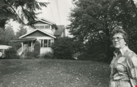
Lillian Mann
https://search.heritageburnaby.ca/link/archivedescription46226
- Repository
- City of Burnaby Archives
- Date
- 1979
- Collection/Fonds
- Columbian Newspaper collection
- Description Level
- Item
- Physical Description
- 1 photograph : b&w ; 15.5 x 24.5 cm
- Scope and Content
- Photograph of Lillian Mann standing outside her home on Cameron Street. Lillian Mann was a war widow who fought for ownership of her property but the City of Burnaby eventually successfully expropriated the land to be used as part of Cameron Library and Recreation Complex.
- Repository
- City of Burnaby Archives
- Date
- 1979
- Collection/Fonds
- Columbian Newspaper collection
- Physical Description
- 1 photograph : b&w ; 15.5 x 24.5 cm
- Description Level
- Item
- Record No.
- 480-1114
- Access Restriction
- No restrictions
- Reproduction Restriction
- Reproduce for fair dealing purposes only
- Accession Number
- 2003-02
- Scope and Content
- Photograph of Lillian Mann standing outside her home on Cameron Street. Lillian Mann was a war widow who fought for ownership of her property but the City of Burnaby eventually successfully expropriated the land to be used as part of Cameron Library and Recreation Complex.
- Subjects
- Buildings - Residential - Houses
- Names
- Mann, Lillian
- Media Type
- Photograph
- Notes
- Title based on contents of photograph
- Geographic Access
- Cameron Street
- Historic Neighbourhood
- Burquitlam (Historic Neighbourhood)
- Planning Study Area
- Lyndhurst Area
Images
![Lillian Mann, [between 1979 and 1982] thumbnail](/media/hpo/_Data/_Archives_Images/_Unrestricted/480/480-1115.jpg?width=280)
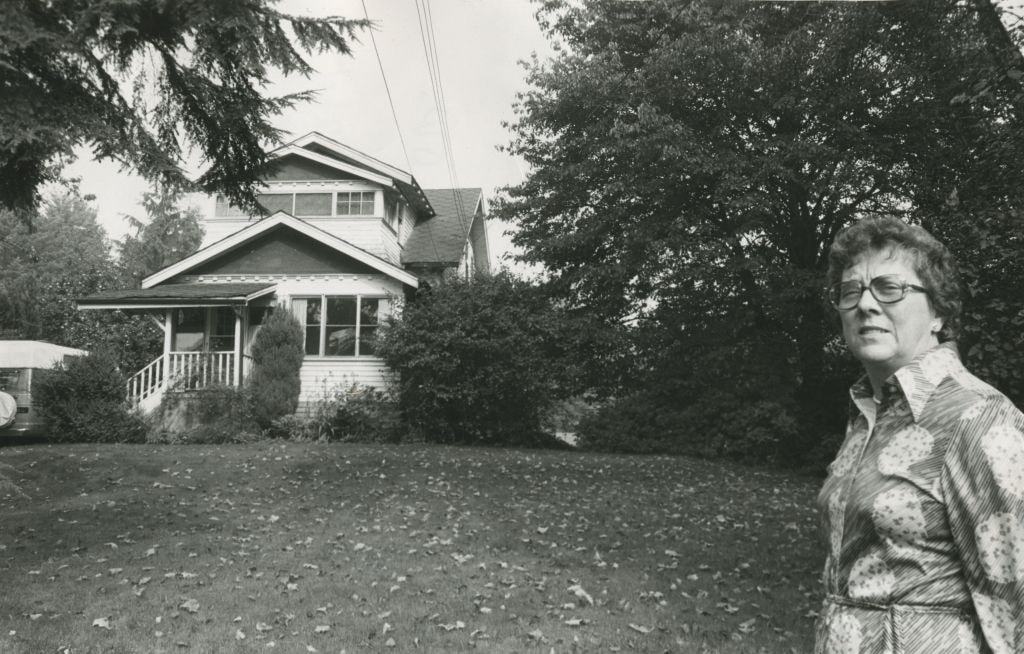
Lillian Mann
https://search.heritageburnaby.ca/link/archivedescription46227
- Repository
- City of Burnaby Archives
- Date
- [between 1979 and 1982]
- Collection/Fonds
- Columbian Newspaper collection
- Description Level
- Item
- Physical Description
- 1 photograph : b&w ; 16 x 22.5 cm
- Scope and Content
- Photograph of Lillian Mann standing outside her home on Cameron Street. Lillian Mann was a war widow who fought for ownership of her property but the City of Burnaby eventually successfully expropriated the land to be used as part of Cameron Library and Recreation Complex.
- Repository
- City of Burnaby Archives
- Date
- [between 1979 and 1982]
- Collection/Fonds
- Columbian Newspaper collection
- Physical Description
- 1 photograph : b&w ; 16 x 22.5 cm
- Description Level
- Item
- Record No.
- 480-1115
- Access Restriction
- No restrictions
- Reproduction Restriction
- Reproduce for fair dealing purposes only
- Accession Number
- 2003-02
- Scope and Content
- Photograph of Lillian Mann standing outside her home on Cameron Street. Lillian Mann was a war widow who fought for ownership of her property but the City of Burnaby eventually successfully expropriated the land to be used as part of Cameron Library and Recreation Complex.
- Subjects
- Buildings - Residential - Houses
- Names
- Mann, Lillian
- Media Type
- Photograph
- Photographer
- Battistoni, Peter
- Notes
- Title based on contents of photograph
- Geographic Access
- Cameron Street
- Historic Neighbourhood
- Burquitlam (Historic Neighbourhood)
- Planning Study Area
- Lyndhurst Area
Images
![Lillian Mann, [between 1979 and 1982] thumbnail](/media/hpo/_Data/_Archives_Images/_Unrestricted/480/480-1115.jpg)
![Lillian Mann, [between 1979 and 1983] thumbnail](/media/hpo/_Data/_Archives_Images/_Unrestricted/480/480-1129.jpg?width=280)
Lillian Mann
https://search.heritageburnaby.ca/link/archivedescription46241
- Repository
- City of Burnaby Archives
- Date
- [between 1979 and 1983]
- Collection/Fonds
- Columbian Newspaper collection
- Description Level
- Item
- Physical Description
- 1 photograph : b&w ; 22.5 x14 cm
- Scope and Content
- Photograph of Lillian Mann standing outside her home on Cameron Street. Lillian Mann was a war widow who fought for ownership of her property but the City of Burnaby eventually successfully expropriated the land to be used as part of Cameron Library and Recreation Complex.
- Repository
- City of Burnaby Archives
- Date
- [between 1979 and 1983]
- Collection/Fonds
- Columbian Newspaper collection
- Physical Description
- 1 photograph : b&w ; 22.5 x14 cm
- Description Level
- Item
- Record No.
- 480-1129
- Access Restriction
- No restrictions
- Reproduction Restriction
- Reproduce for fair dealing purposes only
- Accession Number
- 2003-02
- Scope and Content
- Photograph of Lillian Mann standing outside her home on Cameron Street. Lillian Mann was a war widow who fought for ownership of her property but the City of Burnaby eventually successfully expropriated the land to be used as part of Cameron Library and Recreation Complex.
- Names
- Mann, Lillian
- Media Type
- Photograph
- Photographer
- Battistoni, Peter
- Notes
- Title based on contents of photograph
Images
![Lillian Mann, [between 1979 and 1983] thumbnail](/media/hpo/_Data/_Archives_Images/_Unrestricted/480/480-1129.jpg)
Lou Marcoux and Fred Iacobucci
https://search.heritageburnaby.ca/link/archivedescription56668
- Repository
- City of Burnaby Archives
- Date
- May 1977
- Collection/Fonds
- Columbian Newspaper collection
- Description Level
- Item
- Physical Description
- 1 photograph : b&w ; 13.5 x 14.5 cm
- Scope and Content
- Photograph of Lou Marcoux director of field operations for the ministry of housing, and "worker" Fred Iacobucci when they "got together to try to figure out the metric measurements" at the Forest Meadows open house. Forest Meadows is operated by Strata Council and has 134 suites.
- Repository
- City of Burnaby Archives
- Date
- May 1977
- Collection/Fonds
- Columbian Newspaper collection
- Physical Description
- 1 photograph : b&w ; 13.5 x 14.5 cm
- Description Level
- Item
- Record No.
- 480-1254
- Access Restriction
- No restrictions
- Reproduction Restriction
- No restrictions
- Accession Number
- 2003-02
- Scope and Content
- Photograph of Lou Marcoux director of field operations for the ministry of housing, and "worker" Fred Iacobucci when they "got together to try to figure out the metric measurements" at the Forest Meadows open house. Forest Meadows is operated by Strata Council and has 134 suites.
- Subjects
- Buildings - Residential - Townhouses
- Names
- Marcoux, Lou
- Iacobucci, Fred
- Media Type
- Photograph
- Photographer
- King, Basil
- Notes
- Title based on contents of photograph
- Newspaper clipping attached to verso of photograph reads: "Lou Marcoux, left, director of field operations for the ministry of housing, and worker Fred Iacobucci got together to try to figure out metric measurements Friday at the open house at Forest Meadows housing project in burnaby. The B.C. Housing Corporation is constructing the 134 condominiums on provincial land."
- Geographic Access
- Amberwood Place
- Rosswood Place
- Planning Study Area
- Lake City Area
Images
Peers Family and Hill Family fonds
https://search.heritageburnaby.ca/link/archivedescription98
- Repository
- City of Burnaby Archives
- Date
- [1880-1980]
- Collection/Fonds
- Peers Family and Hill Family fonds
- Description Level
- Fonds
- Physical Description
- ca. 1200 photographs and other material
- Scope and Content
- Fonds consists of records, primarily photographs, compiled by various members of both the Hill and Peers families that document their lives during the early days of settlement in Burnaby. The fonds includes records of citizenship, wills and other official papers pertaining to the life and activitie…
- Repository
- City of Burnaby Archives
- Date
- [1880-1980]
- Collection/Fonds
- Peers Family and Hill Family fonds
- Physical Description
- ca. 1200 photographs and other material
- Description Level
- Fonds
- Access Restriction
- No restrictions
- Accession Number
- 2007-12
- Scope and Content
- Fonds consists of records, primarily photographs, compiled by various members of both the Hill and Peers families that document their lives during the early days of settlement in Burnaby. The fonds includes records of citizenship, wills and other official papers pertaining to the life and activities of L. Claude Hill; photographs of the Peers family’s Burnaby Lake home, Greyfriars, and pictures taken by Arthur Peers during his work and travels throughout British Columbia in the first part of the 20th century; and photographs of the family of Claude Hill, early Burnaby Lake residents and scenes, and pictures Kitty took as an adult documenting the growth of her own family. Also included in this fonds are a number of photographs showing Yellow Point, Vancouver Island, where the Peers and Hill families often vacationed.
- History
- Bob Peers was born William John Peers, the son of real estate broker and early Burnaby resident, Francis John Peers and his wife Elizabeth Frisby. Originally from England, the family moved to Vancouver in 1905 and soon after settled at Burnaby Lake. The family included one daughter (Mary Elizabeth Dora) and four boys (Arthur Francis, William John “Bob”, Geoffrey Hugh, and Richard Dominic). When they arrived in Burnaby, Francis Peers purchased a piece of land from another early settler, Claude Hill, and built the family home “Greyfriars” near Deer Lake. The children attended school in the home of Miss Harriet Woodward, the first school to be held in the Burnaby Lake area. In 1925, Bob married Claude Hill’s daughter and another former pupil of “Miss Harry’s,” Kitty Hill. Kitty (born Katherine Maude Hill) was the only child of Burnaby pioneers L. Claude Hill and Annie Sara Kenrick. Having moved to the Burnaby Lake area in the early 1890s, Claude went on to operate a successful strawberry farm and soon became active in the political development of Burnaby – being elected to the first Burnaby Council and serving from 1892-1894 and again from 1909-1910. The first Hill family home, “Brookfield,” was sold around 1907 and the family moved to their new home, “Broadview,” which was also built in the vicinity of Deer Lake. In 1925, Bob and Kitty were married and they went on to have three children, Robert C.K., Barbara (later Barbara Jeffrey), and Anne (later Anne Latham).
- Formats
- All photographic records have been scanned and are saved in jpeg format on the City of Burnaby network. Archival master copies have also been produced in tiff format and have been burned to CD for preservation purposes.
- Media Type
- Textual Record
- Photograph
- Creator
- Peers family
- Hill family
- Notes
- Title based on contents of fonds
Pixie McGeachie subseries
https://search.heritageburnaby.ca/link/archivedescription101
- Repository
- City of Burnaby Archives
- Date
- 1910 (date of original)-2004
- Collection/Fonds
- Burnaby Historical Society fonds
- Description Level
- Subseries
- Physical Description
- Textual records and photographs
- Scope and Content
- Subseries consists of papers and photographs collected by Pixie McGeachie during her tenure as archivist for the Burnaby Historical Society Community Archives. Also included are newspaper articles and essays penned by Pixie, a series of research files collected and organized for her own personal u…
- Repository
- City of Burnaby Archives
- Date
- 1910 (date of original)-2004
- Collection/Fonds
- Burnaby Historical Society fonds
- Subseries
- Pixie McGeachie subseries
- Physical Description
- Textual records and photographs
- Description Level
- Subseries
- Accession Number
- BHS1989-28
- BHS1991-07
- BHS1992-39
- BHS1992-56
- BHS1992-58
- BHS1996-06
- BHS1996-16
- BHS1997-01
- BHS2004-02
- BHS1991-16
- BHS1999-13
- BHS1996-08
- BHS1996-07
- BHS2000-03
- BHS2003-01
- Scope and Content
- Subseries consists of papers and photographs collected by Pixie McGeachie during her tenure as archivist for the Burnaby Historical Society Community Archives. Also included are newspaper articles and essays penned by Pixie, a series of research files collected and organized for her own personal use and a selection of ephemera.
- History
- Doreen "Pixie" McGeachie was a resident of Burnaby for over 60 years. She served as the editor for the Burnaby Examiner newspaper and wrote a column entitled "Burnaby History" for The News. In 1974 she authored her first book titled "Bygones of Burnaby" which was one of the first to develop anecdotal stories about pioneer life in Burnaby. She authored "Burnaby - A Proud Century" in 1992 and in 2002 she wrote a biography of the city's namesake in the book "Land of Promise: Robert Burnaby's letters from Colonial B.C." Pixie also contributed many hours of volunteering; helping to establish Burnaby's first museum Heritage Village in 1971, serving as President of the Burnaby Historical Society from 1991-1993. She served a six year term on Burnaby's Heritage Commission, leading the charge to preserve many historic sites throughout the city, and during her twenty years as the Community Archives volunteer archivist for the Historical Society, she succeeded in gathering thousands of rare and valuable historic photographs and documents which now forms the core of the photograph collection on the Heritage Burnaby website. The City of Burnaby awarded Pixie McGeachie the Kushiro Cup as Citizen of the Year in 2002. In 2006 she received a Heritage BC project award for leading the Friends of Interurban 1223 project, and in 2008 Heritage BC recognised her again by presenting her with the Ruby Nobb Award. Pixie McGeachie passed away in August of 2010. On 24 September, 2011, the City of Burnaby dedicated the reading room at the City Archives in her honour and formally named it the Pixie McGeachie Reading Room in recognition of her years of service to the community.
- Media Type
- Textual Record
- Photograph
- Creator
- McGeachie, Doreen “Pixie”
- Notes
- Title based on creator of subseries
- PC299, PC237, PC332, PC460, MSS054, MSS065, and MSS081
Planning Department fonds
https://search.heritageburnaby.ca/link/archivedescription102
- Repository
- City of Burnaby Archives
- Date
- 1940-2016
- Collection/Fonds
- Planning Department fonds
- Description Level
- Fonds
- Physical Description
- 80 m of textual records and other material
- Scope and Content
- Fonds consists of those records created during the regular conduct of business by the Planning Department and its predecessor agencies according to their mandate of providing professional and technical advice to Council on the current and future uses of City land and resources.
- Repository
- City of Burnaby Archives
- Date
- 1940-2016
- Collection/Fonds
- Planning Department fonds
- Physical Description
- 80 m of textual records and other material
- Description Level
- Fonds
- File Class
- 71000 10 (add. 2020)
- 71000 20 (add. 2020)
- 71000 30 (add. 2020)
- 71000 40 (add. 2020)
- Access Restriction
- Subject to FOIPPA
- Reproduction Restriction
- Reproductions subject to FOIPPA.
- Scope and Content
- Fonds consists of those records created during the regular conduct of business by the Planning Department and its predecessor agencies according to their mandate of providing professional and technical advice to Council on the current and future uses of City land and resources.
- History
- The City of Burnaby Planning Department was established on October 9, 1956, when the City Council unanimously carried the motion to create a distinct department to deal with planning issues within the City and appointed Mr. William John Blakely as its head. This decision followed a report and recommendation made by the City’s Chief Administrative Officer which indicated that the role of the Planning Engineer and his staff had quickly expanded to become a separate division within the Engineering Department and that they were functioning as an independent unit in all but name. The proposed separation of the Engineering and Planning departments had been in the works since the early part of 1956 when staff changes and restructuring within the Engineering Department’s Planning Division illustrated the undermanned condition of the Planning Engineer’s office. As a result, Council asked the Chief Administrative Officer to undertake a study examining the feasibility of creating a distinct Planning Department. This report was delivered to Council on July 3, 1956, but was laid over until a Committee of the Council had the opportunity to study the functions of the Planning department to determine the necessity of the proposal. The Committee’s findings were in line with the initial report and the Planning Department was established with a staff of nine (the head Planning Engineer, an Administrative Planner, three Research Planning Assistants, a Draughtsman, a Subdivision Control Clerk, a department Clerk and a Clerk Stenographer). This new department was to offer advice and carry out the work intensive in matters such as zoning and rezoning applications, subdivision control, traffic and transportation planning, and general City planning schemes. Prior to the creation of the Planning Department, a number of bodies within the City had been responsible for fulfilling the functions carried out by this new unit. In the earliest years of the City, the members of Council were responsible for matters of planning and were assisted in their job by the City’s Engineer or any number of hired consultants (e.g. surveyors, cartographers). By 1906, however, the provincial laws surrounding the subdivision process had changed, and local governments were charged with the task of approving all private subdivision plans in their respective Municipalities. In Burnaby, the City Council passed a bylaw decreeing that all subdivision plans were to be submitted to Council for review and the City Engineer was responsible for ensuring compliance with the law. After the first Town Planning Bylaw in 1924 which restricted the type and size of construction that could occur in certain City areas, the Engineering and Building departments were to work together to oversee the enforcement of the Bylaw and the development of City plans. The scope and competence required to carry out this work grew as Burnaby’s population expanded, and in 1930 Council passed the Town Planning Commission Bylaw (No. 1028) that saw the creation of a permanent body – the Town Planning Commission – which was to serve as an advisory body to help direct the planning activities in the City while the actual work continued to be carried out by the Engineering Department. This body was comprised of the Reeve, the Chairman of the School Board, the Chairman of the Park Committee (later, the Board of Parks Commissioners), and six appointed citizens who served three-year terms. Council referred all matters of subdivisions, transportation planning, and rezoning to this Commission, which was later supported in its work by several other special or standing committees such as the Subdivision Committee, the Apartment Committee, the Transportation Committee or the Town Planning Board of Appeal. By 1953, it had become apparent that the advisory committees that were dedicated to these planning issues needed a permanent staff to carry out the work intensive, so a restructuring of the Engineering department resulted in a permanent Planning Engineer’s office being created. The Town Planning Commission continued in its advisory capacity even after the determination came in 1956 to create a separate Planning Department. When Bylaw No. 4473 was passed in 1963, the Town Planning Commission was disbanded in favour of a new Advisory Planning Commission that would turn over all routine matters such as subdivision and rezoning applications to the Planning Department but would offer advice and community input into the more complex planning schemes within the City and act as an intermediary in cases where Council and Planning staff were in disagreement. A new Advisory Planning Commission Bylaw (No. 7600) was adopted in 1980 which allowed for even greater community participation in the planning process. The Planning Department was initially responsible to report directly to Council, but in 1957, the administrative structure of Municipal staff changed with the introduction of the Burnaby Municipal Manager Bylaw (No. 3859) and from that point on, the head of the Planning Department held a direct reporting relationship to the Municipal Manager, who in turn was responsible for reporting the activities of the Department to the City Council. Over the years, the internal structure and the scope of responsibilities of the Department have changed during periods of staff reorganizations. Under the larger umbrella of the Planning and Building Department, Planning has come to be comprised of two divisions: the Current Planning Division and the Long Range Planning Division. The functions of the Current Planning Division include rezoning, subdivision, development plan areas, preliminary plan approvals, urban design, heritage planning, and urban trails and bicycle routes. The Long Range Planning Division is responsible for environmental planning concerns, transportation planning, housing, neighbourhood area planning, social planning and planning information services. In 2022, the Planning and Building Department was reorganized to better align functions with delivery of services. The Climate Action and Engery Division moved from Corporate Services to the Planning and Building Department, while Indigenous Relations and Facilities Management moved to Corporate Services and Lands and Facilities, respectively. The position of Director of Planning and Building was changed to General Manager, Planning and Development. The following individuals have served as Planning Engineer and/or Director of the Planning Department and/or General Manager, Planning and Development for the City of Burnaby: William John Blakely 1954-1956 (as Planning Engineer) 1956-1963 (as Head of the Department) Anthony P. Parr 1964-1993 Don G. Stenson 1993-2001 Jack S. Belhouse 2001-2006 Basil Luksun 2006-2012 Lou Pelletier 2012-2019 Edward Kozak 2019-present
- Formats
- Microforms exist for some records. See series descriptions.
- Media Type
- Textual Record
- Photograph
- Moving Images
- Creator
- City of Burnaby
- Notes
- Title based on contents of fonds
Ross family subseries
https://search.heritageburnaby.ca/link/archivedescription114
- Repository
- City of Burnaby Archives
- Date
- 1922(date of originals)-[1998]
- Collection/Fonds
- Burnaby Historical Society fonds
- Description Level
- Subseries
- Physical Description
- 2 files of textual records and 2 photographs
- Scope and Content
- Subseries consists of Ross family history, memories of the Burnaby Lake Interurban, Ross Service Station letterhead and photographs of the Ross Service Station.
- Repository
- City of Burnaby Archives
- Date
- 1922(date of originals)-[1998]
- Collection/Fonds
- Burnaby Historical Society fonds
- Subseries
- Ross family subseries
- Physical Description
- 2 files of textual records and 2 photographs
- Description Level
- Subseries
- Accession Number
- BHS1998-05
- BHS1999-14
- Scope and Content
- Subseries consists of Ross family history, memories of the Burnaby Lake Interurban, Ross Service Station letterhead and photographs of the Ross Service Station.
- History
- Frederick "Fred" Sullivan Ross was born 1887 in Edinburgh, Scotland. He took his apprenticeship in mechanics in Glasgow prior to 1911, following which he immigrated to Canada. During the First World War he returned to Britain and joined the Royal Navy. He was a Chief Petty Officer, working in the engine room of a mine sweeper in the North Atlantic. Margaret Binnie Dougal was in 1884 in Linlithgow, Scotland. She trained as a nurse before emigrating to Canada in 1911. She also returned to Britain during the war years, nursing at Boulogne in France and later Bristol before returning to Vancouver in 1919. She met Fred through a mutual friend, Agnes Rhind. Fred and Margaret married in 1920 in Vancouver, BC. Their first home was in North Vancouver and was where their first child, Ronald, was born. In 1921 or 1922 they moved to the Burnaby Lake area, buying a three-quarter acre parcel of land at 2974 Sprott Street and had two more children, Ian and Alistair. Fred built, owned and operated the Ross Service Station on Douglas Road, established in 1922 or 1923. The station property ran from Douglas Road up to the Douglas Road School’s fence line. After the municipality appropriated part of the property in the 1930s to create a junction for the new Grandview Highway and existing Douglas Road, Fred got permission to build an upper station with two more pumps. The driveway curved down to the station from where Sprott Street now joins Canada Way and rejoined that road near its junction with Douglas Road. At Ross Service Station, Fred did automobile repairs and used the family car, a Studebaker Commander, as a towing vehicle. He created a garden north of the service station on the upper level where he grew chrysanthemums and daises. In the 1930s, Terry Rowley worked at the service station as one of Fred’s assistants. Fred ran the station until he sold it in about 1949. Margaret died December 29, 1969 at the age of 85. Fred died on August 21, 1971 at the age of 84.
- Media Type
- Textual Record
- Photograph
- Creator
- Ross family
- Notes
- Title based on contents of subseries
- PC58 and MSS146