More like 'Lyle Le Grove'
Narrow Results By
Decade
- 2020s 86
- 2010s 41
- 2000s 480
- 1990s 378
- 1980s 370
- 1970s
- 1960s 280
- 1950s 462
- 1940s 419
- 1930s 348
- 1920s 370
- 1910s 440
- 1900s 173
- 1890s 23
- 1880s 49
- 1870s 3
- 1860s 1
- 1850s 1
- 1840s 1
- 1830s 1
- 1820s 1
- 1810s 1
- 1800s 1
- 1790s 1
- 1780s 1
- 1770s 1
- 1760s 1
- 1750s 1
- 1740s 1
- 1730s 1
- 1720s 1
- 1710s 1
- 1700s 1
- 1690s 1
- 1680s 1
- 1670s 1
- 1660s 1
- 1650s 1
- 1640s 1
- 1630s 1
- 1620s 1
- 1610s 1
- 1600s 1
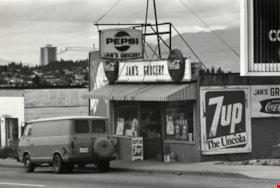
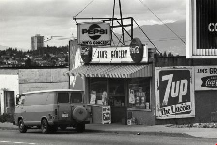
Jan's Grocery Store
https://search.heritageburnaby.ca/link/archivedescription79080
- Repository
- City of Burnaby Archives
- Date
- October, 1976
- Collection/Fonds
- Burnaby Public Library Contemporary Visual Archive Project
- Description Level
- Item
- Physical Description
- 1 photograph : b&w ; 11 x 16 cm mounted on cardboard
- Scope and Content
- Photograph shows Jan's Grocery store located at 4759 Hastings Street.
- Repository
- City of Burnaby Archives
- Date
- October, 1976
- Collection/Fonds
- Burnaby Public Library Contemporary Visual Archive Project
- Physical Description
- 1 photograph : b&w ; 11 x 16 cm mounted on cardboard
- Description Level
- Item
- Record No.
- 556-140
- Access Restriction
- No restrictions
- Reproduction Restriction
- Reproduce for fair dealing purposes only
- Accession Number
- 2013-13
- Scope and Content
- Photograph shows Jan's Grocery store located at 4759 Hastings Street.
- Names
- Jan's Grocery
- Media Type
- Photograph
- Photographer
- Cook, Alan
- Notes
- Scope note taken directly from BPL photograph description.
- 1 b&w copy negative : 10 x 12.5 cm accompanying
- Geographic Access
- Hastings Street
- Street Address
- 4759 Hastings Street
- Historic Neighbourhood
- Capitol Hill (Historic Neighbourhood)
- Planning Study Area
- Capitol Hill Area
Images
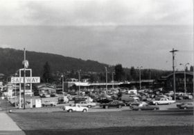
Kensington Plaza
https://search.heritageburnaby.ca/link/archivedescription79133
- Repository
- City of Burnaby Archives
- Date
- October 16, 1976
- Collection/Fonds
- Burnaby Public Library Contemporary Visual Archive Project
- Description Level
- Item
- Physical Description
- 1 photograph : b&w ; 11 x 16 cm mounted on cardboard
- Scope and Content
- Photograph shows the parking lot at the Kensington Plaza on Hastings Street at the corner of Kensington Avenue.
- Repository
- City of Burnaby Archives
- Date
- October 16, 1976
- Collection/Fonds
- Burnaby Public Library Contemporary Visual Archive Project
- Physical Description
- 1 photograph : b&w ; 11 x 16 cm mounted on cardboard
- Description Level
- Item
- Record No.
- 556-175
- Access Restriction
- No restrictions
- Reproduction Restriction
- Reproduce for fair dealing purposes only
- Accession Number
- 2013-13
- Scope and Content
- Photograph shows the parking lot at the Kensington Plaza on Hastings Street at the corner of Kensington Avenue.
- Subjects
- Buildings - Commercial - Stores
- Names
- Safeway
- Media Type
- Photograph
- Notes
- Scope note taken directly from BPL photograph description.
- 1 b&w copy negative : 10 x 12.5 cm accompanying
- Photographers identified by surnames only: Carr and Vardeman
- Geographic Access
- Hastings Street
- Street Address
- 6500 Hastings Street
- Historic Neighbourhood
- Lochdale (Historic Neighbourhood)
- Planning Study Area
- Lochdale Area
Images

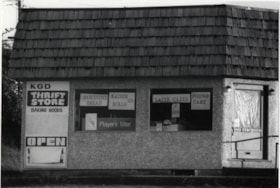
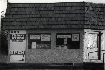
KGD Thrift Store
https://search.heritageburnaby.ca/link/archivedescription79109
- Repository
- City of Burnaby Archives
- Date
- September, 1976
- Collection/Fonds
- Burnaby Public Library Contemporary Visual Archive Project
- Description Level
- Item
- Physical Description
- 1 photograph : b&w ; 11 x 16 cm mounted on cardboard
- Scope and Content
- Photograph shows the KDG Thrift Store at 4626 Canada Way near Wayburne Drive. The building was constructed approximately 1946.
- Repository
- City of Burnaby Archives
- Date
- September, 1976
- Collection/Fonds
- Burnaby Public Library Contemporary Visual Archive Project
- Physical Description
- 1 photograph : b&w ; 11 x 16 cm mounted on cardboard
- Description Level
- Item
- Record No.
- 556-158
- Access Restriction
- No restrictions
- Reproduction Restriction
- Reproduce for fair dealing purposes only
- Accession Number
- 2013-13
- Scope and Content
- Photograph shows the KDG Thrift Store at 4626 Canada Way near Wayburne Drive. The building was constructed approximately 1946.
- Names
- KGD Thrift Store
- Media Type
- Photograph
- Photographer
- Salmon, Stu
- Notes
- Scope note taken directly from BPL photograph description.
- 1 b&w copy negative : 10 x 12.5 cm accompanying
- Geographic Access
- Canada Way
- Street Address
- 4626 Canada Way
- Planning Study Area
- Douglas-Gilpin Area
Images
![Libonati's Gun Shop exterior, [1970] thumbnail](/media/hpo/_Data/_Archives_Images/_Unrestricted/513/522-001.JPG?width=280)
Libonati's Gun Shop exterior
https://search.heritageburnaby.ca/link/archivedescription66101
- Repository
- City of Burnaby Archives
- Date
- [1970]
- Collection/Fonds
- Libonati family fonds
- Description Level
- Item
- Physical Description
- 1 photograph (jpeg)
- Scope and Content
- Photograph depicts an exterior view of Libonati's Gun Shop and Sporting Goods at 4261 Kingsway, along with other businesses on that block. Businesses left to right: Quality Auto Electric, Libonati's Gun Shop and Sporting Goods and Inter City Bowl bowling alley. Not shown in the picture were two o…
- Repository
- City of Burnaby Archives
- Date
- [1970]
- Collection/Fonds
- Libonati family fonds
- Physical Description
- 1 photograph (jpeg)
- Description Level
- Item
- Record No.
- 522-001
- Access Restriction
- No restrictions
- Reproduction Restriction
- Reproduce for fair dealing purposes only
- Accession Number
- 2011-02
- Scope and Content
- Photograph depicts an exterior view of Libonati's Gun Shop and Sporting Goods at 4261 Kingsway, along with other businesses on that block. Businesses left to right: Quality Auto Electric, Libonati's Gun Shop and Sporting Goods and Inter City Bowl bowling alley. Not shown in the picture were two other business east of the bowling alley; namely, Low Cost Transmission and Kilpatrick Nursing Home which was at the corner of Chaffey before Chaffey was realigned. Libonati's Gun Shop was owned and operated by Denzil (Dan) Libonati, a long-time Burnaby businessman. Cars in the picture are a 1959 Willy's Jeep (Denzil's) and 1958 Chevrolet (unknown owner).
- Names
- Libonati's Gun Shop
- Media Type
- Photograph
- Geographic Access
- Kingsway
- Street Address
- 4261 Kingsway
- Historic Neighbourhood
- Central Park (Historic Neighbourhood)
- Planning Study Area
- Maywood Area
Images
![Libonati's Gun Shop exterior, [1970] thumbnail](/media/hpo/_Data/_Archives_Images/_Unrestricted/513/522-001.JPG)
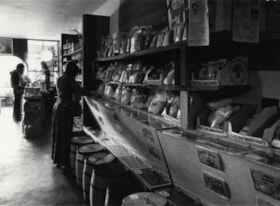
Manna Natural Foods
https://search.heritageburnaby.ca/link/archivedescription79119
- Repository
- City of Burnaby Archives
- Date
- September, 1976
- Collection/Fonds
- Burnaby Public Library Contemporary Visual Archive Project
- Description Level
- Item
- Physical Description
- 1 photograph : b&w ; 11 x 16 cm mounted on cardboard
- Scope and Content
- Photograph shows customers inside Manna Natural Foods at 4521 Hastings Street.
- Repository
- City of Burnaby Archives
- Date
- September, 1976
- Collection/Fonds
- Burnaby Public Library Contemporary Visual Archive Project
- Physical Description
- 1 photograph : b&w ; 11 x 16 cm mounted on cardboard
- Description Level
- Item
- Record No.
- 556-165
- Access Restriction
- No restrictions
- Reproduction Restriction
- Reproduce for fair dealing purposes only
- Accession Number
- 2013-13
- Scope and Content
- Photograph shows customers inside Manna Natural Foods at 4521 Hastings Street.
- Names
- Manna Natural Foods
- Media Type
- Photograph
- Photographer
- Campbell, Peg
- Notes
- Scope note taken directly from BPL photograph description.
- 1 b&w copy negative : 10 x 12.5 cm accompanying
- Geographic Access
- Hastings Street
- Street Address
- 4521 Hastings Street
- Historic Neighbourhood
- Capitol Hill (Historic Neighbourhood)
- Planning Study Area
- Capitol Hill Area
Images

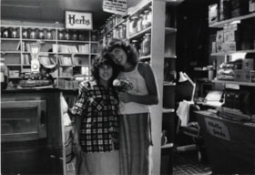
Manna Natural Foods
https://search.heritageburnaby.ca/link/archivedescription79120
- Repository
- City of Burnaby Archives
- Date
- September, 1976
- Collection/Fonds
- Burnaby Public Library Contemporary Visual Archive Project
- Description Level
- Item
- Physical Description
- 1 photograph : b&w ; 11 x 16 cm mounted on cardboard
- Scope and Content
- Photograph shows two employees inside Manna Natural Foods in front of the herb counter.
- Repository
- City of Burnaby Archives
- Date
- September, 1976
- Collection/Fonds
- Burnaby Public Library Contemporary Visual Archive Project
- Physical Description
- 1 photograph : b&w ; 11 x 16 cm mounted on cardboard
- Description Level
- Item
- Record No.
- 556-166
- Access Restriction
- No restrictions
- Reproduction Restriction
- Reproduce for fair dealing purposes only
- Accession Number
- 2013-13
- Scope and Content
- Photograph shows two employees inside Manna Natural Foods in front of the herb counter.
- Names
- Manna Natural Foods
- Media Type
- Photograph
- Photographer
- Campbell, Peg
- Notes
- Scope note taken directly from BPL photograph description.
- 1 b&w copy negative : 10 x 12.5 cm accompanying
- Geographic Access
- Hastings Street
- Street Address
- 4521 Hastings Street
- Historic Neighbourhood
- Capitol Hill (Historic Neighbourhood)
- Planning Study Area
- Capitol Hill Area
Images


Nelsons Grocery
https://search.heritageburnaby.ca/link/archivedescription79100
- Repository
- City of Burnaby Archives
- Date
- October, 1976
- Collection/Fonds
- Burnaby Public Library Contemporary Visual Archive Project
- Description Level
- Item
- Physical Description
- 1 photograph : b&w ; 11 x 16 cm mounted on cardboard
- Scope and Content
- Photograph shows Nelsons Grocery at 4909 Rumble Street at the corner of Nelson Avenue and Rumble Street.
- Repository
- City of Burnaby Archives
- Date
- October, 1976
- Collection/Fonds
- Burnaby Public Library Contemporary Visual Archive Project
- Physical Description
- 1 photograph : b&w ; 11 x 16 cm mounted on cardboard
- Description Level
- Item
- Record No.
- 556-152
- Access Restriction
- No restrictions
- Reproduction Restriction
- Reproduce for fair dealing purposes only
- Accession Number
- 2013-13
- Scope and Content
- Photograph shows Nelsons Grocery at 4909 Rumble Street at the corner of Nelson Avenue and Rumble Street.
- Names
- Nelsons Grocery
- Media Type
- Photograph
- Photographer
- McCarron, John
- Notes
- Scope note taken directly from BPL photograph description.
- 1 b&w copy negative : 10 x 12.5 cm accompanying
- Geographic Access
- Rumble Street
- Nelson Avenue
- Street Address
- 4909 Rumble Street
- Historic Neighbourhood
- Alta-Vista (Historic Neighbourhood)
- Planning Study Area
- Sussex-Nelson Area
Images


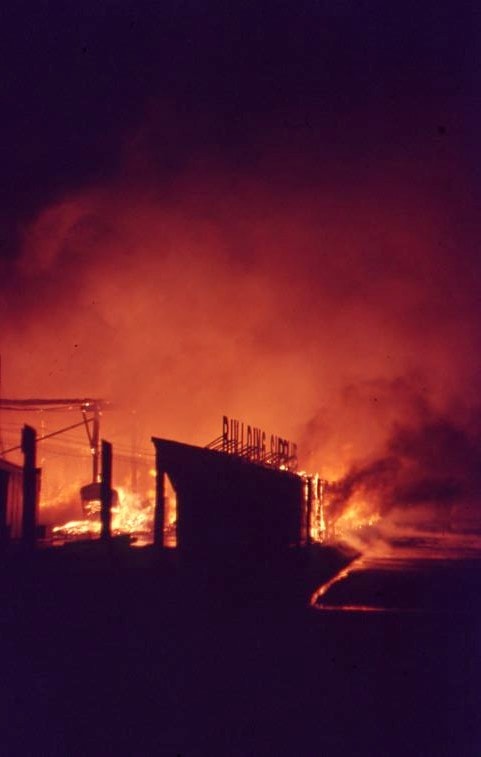
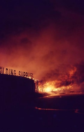
Nighttime fire at Lumberland
https://search.heritageburnaby.ca/link/museumdescription4312
- Repository
- Burnaby Village Museum
- Date
- 24 Aug. 1970
- Collection/Fonds
- Burnaby Village Museum Photograph collection
- Description Level
- Item
- Physical Description
- 1 photograph : col. ; 35 mm
- Scope and Content
- Photograph of a nighttime fire at Lumberland, located at 5650 Lougheed Highway.
- Repository
- Burnaby Village Museum
- Collection/Fonds
- Burnaby Village Museum Photograph collection
- Description Level
- Item
- Physical Description
- 1 photograph : col. ; 35 mm
- Material Details
- The slide was processed in Canachrome by Mortifee.
- Handwritten text in ink on slide frame reads: "Lumberland / Aug 24 /70".
- Scope and Content
- Photograph of a nighttime fire at Lumberland, located at 5650 Lougheed Highway.
- Names
- Farmer, Joanne
- Lumberland
- Geographic Access
- Lougheed Highway
- Street Address
- 5650 Lougheed Highway
- Accession Code
- BV017.42.7
- Access Restriction
- No restrictions
- Reproduction Restriction
- No known restrictions
- Date
- 24 Aug. 1970
- Media Type
- Photograph
- Planning Study Area
- Dawson-Delta Area
- Scan Resolution
- 600
- Scan Date
- 05-Jun-2018
- Notes
- Title based on content of photograph.
Images
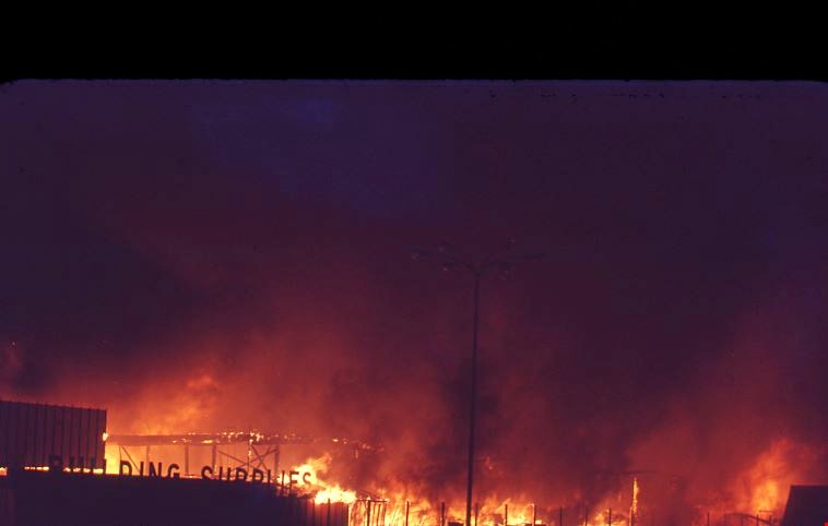
Nighttime fire at Lumberland
https://search.heritageburnaby.ca/link/museumdescription4313
- Repository
- Burnaby Village Museum
- Date
- 24 Aug. 1970
- Collection/Fonds
- Burnaby Village Museum Photograph collection
- Description Level
- Item
- Physical Description
- 1 photograph : col. ; 35 mm
- Scope and Content
- Photograph of a nighttime fire at Lumberland, located at 5650 Lougheed Highway.
- Repository
- Burnaby Village Museum
- Collection/Fonds
- Burnaby Village Museum Photograph collection
- Description Level
- Item
- Physical Description
- 1 photograph : col. ; 35 mm
- Material Details
- The slide was processed in Canachrome by Mortifee.
- Handwritten text in ink on slide frame reads: "Lumberland / Fire Aug 24 /70".
- Scope and Content
- Photograph of a nighttime fire at Lumberland, located at 5650 Lougheed Highway.
- Names
- Farmer, Joanne
- Lumberland
- Geographic Access
- Lougheed Highway
- Street Address
- 5650 Lougheed Highway
- Accession Code
- BV017.42.8
- Access Restriction
- No restrictions
- Reproduction Restriction
- No known restrictions
- Date
- 24 Aug. 1970
- Media Type
- Photograph
- Planning Study Area
- Dawson-Delta Area
- Scan Resolution
- 600
- Scan Date
- 05-Jun-2018
- Notes
- Title based on contents of photograph
Images


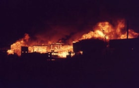
Nighttime fire at Lumberland
https://search.heritageburnaby.ca/link/museumdescription4314
- Repository
- Burnaby Village Museum
- Date
- 24 Aug. 1970
- Collection/Fonds
- Burnaby Village Museum Photograph collection
- Description Level
- Item
- Physical Description
- 1 photograph : col. ; 35 mm
- Scope and Content
- Photograph of a nighttime fire at Lumberland, located at 5650 Lougheed Highway.
- Repository
- Burnaby Village Museum
- Collection/Fonds
- Burnaby Village Museum Photograph collection
- Description Level
- Item
- Physical Description
- 1 photograph : col. ; 35 mm
- Material Details
- The slide was processed in Canachrome by Mortifee.
- Handwritten text in ink on slide frame reads: "Lumberland Fire / Aug 24 /70".
- Scope and Content
- Photograph of a nighttime fire at Lumberland, located at 5650 Lougheed Highway.
- Names
- Farmer, Joanne
- Lumberland
- Geographic Access
- Lougheed Highway
- Street Address
- 5650 Lougheed Highway
- Accession Code
- BV017.42.9
- Access Restriction
- No restrictions
- Reproduction Restriction
- No known restrictions
- Date
- 24 Aug. 1970
- Media Type
- Photograph
- Planning Study Area
- Dawson-Delta Area
- Scan Resolution
- 600
- Scan Date
- 05-Jun-2018
- Notes
- Title based on contents of photograph
Images
Nighttime fire at Lumberland
https://search.heritageburnaby.ca/link/museumdescription4315
- Repository
- Burnaby Village Museum
- Date
- 24 Aug. 1970
- Collection/Fonds
- Burnaby Village Museum Photograph collection
- Description Level
- Item
- Physical Description
- 1 photograph : col. ; 35 mm
- Scope and Content
- Photograph of a nighttime fire at Lumberland, located at 5650 Lougheed Highway.
- Repository
- Burnaby Village Museum
- Collection/Fonds
- Burnaby Village Museum Photograph collection
- Description Level
- Item
- Physical Description
- 1 photograph : col. ; 35 mm
- Material Details
- The slide was processed in Canachrome by Mortifee.
- Handwritten text in ink on slide frame reads: "Lumberland / Fire Aug 24 /70".
- Scope and Content
- Photograph of a nighttime fire at Lumberland, located at 5650 Lougheed Highway.
- Other Title Information
- Title based on content of photograph.
- Names
- Farmer, Joanne
- Lumberland
- Geographic Access
- Lougheed Highway
- Street Address
- 5650 Lougheed Highway
- Accession Code
- BV017.42.10
- Access Restriction
- No restrictions
- Reproduction Restriction
- No known restrictions
- Date
- 24 Aug. 1970
- Media Type
- Photograph
- Planning Study Area
- Dawson-Delta Area
- Scan Resolution
- 600
- Scan Date
- 05-Jun-2018
- Notes
- Title based on contents of photograph
Images

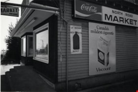
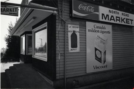
North Road Market
https://search.heritageburnaby.ca/link/archivedescription79108
- Repository
- City of Burnaby Archives
- Date
- September 20, 1976
- Collection/Fonds
- Burnaby Public Library Contemporary Visual Archive Project
- Description Level
- Item
- Physical Description
- 1 photograph : b&w ; 11 x 16 cm mounted on cardboard
- Scope and Content
- Photograph shows the North Road Market located at 3569 North Road.
- Repository
- City of Burnaby Archives
- Date
- September 20, 1976
- Collection/Fonds
- Burnaby Public Library Contemporary Visual Archive Project
- Physical Description
- 1 photograph : b&w ; 11 x 16 cm mounted on cardboard
- Description Level
- Item
- Record No.
- 556-157
- Access Restriction
- No restrictions
- Reproduction Restriction
- Reproduce for fair dealing purposes only
- Accession Number
- 2013-13
- Scope and Content
- Photograph shows the North Road Market located at 3569 North Road.
- Names
- North Road Market
- Media Type
- Photograph
- Photographer
- Campbell, Peg
- Notes
- Scope note taken directly from BPL photograph description.
- 1 b&w copy negative : 10 x 12.5 cm accompanying
- Geographic Access
- North Road
- Street Address
- 3569 North Road
- Historic Neighbourhood
- Burquitlam (Historic Neighbourhood)
- Planning Study Area
- Cameron Area
Images
![Paulette's Beauty Salon, [196-] thumbnail](/media/hpo/_Data/_Archives_Images/_Unrestricted/316/366-030.jpg?width=280)
Paulette's Beauty Salon
https://search.heritageburnaby.ca/link/archivedescription97615
- Repository
- City of Burnaby Archives
- Date
- [196-]
- Collection/Fonds
- Burnaby Historical Society fonds
- Description Level
- Item
- Physical Description
- 1 photograph : b&w negative
- Scope and Content
- Photograph of Paulette's Beauty Salon located at 3945 East Hastings Street in North Burnaby.
- Repository
- City of Burnaby Archives
- Date
- [196-]
- Collection/Fonds
- Burnaby Historical Society fonds
- Subseries
- Municipal record subseries
- Physical Description
- 1 photograph : b&w negative
- Description Level
- Item
- Record No.
- 366-030
- Access Restriction
- No restrictions
- Reproduction Restriction
- Reproduce for fair dealing purposes only
- Accession Number
- BHS1998-12
- Scope and Content
- Photograph of Paulette's Beauty Salon located at 3945 East Hastings Street in North Burnaby.
- Subjects
- Buildings - Commercial - Stores
- Names
- Paulettes Beauty Salon
- Media Type
- Photograph
- Notes
- Title based on content of photograph
- Geographic Access
- Hastings Street
- Historic Neighbourhood
- Vancouver Heights (Historic Neighbourhood)
- Planning Study Area
- Burnaby Heights Area
Images
![Paulette's Beauty Salon, [196-] thumbnail](/media/hpo/_Data/_Archives_Images/_Unrestricted/316/366-030.jpg)
![Ray Loewen with his family, [between 1975 and 1979] thumbnail](/media/hpo/_Data/_Archives_Images/_Unrestricted/480/480-834.jpg?width=280)
Ray Loewen with his family
https://search.heritageburnaby.ca/link/archivedescription45940
- Repository
- City of Burnaby Archives
- Date
- [between 1975 and 1979]
- Collection/Fonds
- Columbian Newspaper collection
- Description Level
- Item
- Physical Description
- 1 photograph : b&w ; 7.5 x 11 cm
- Scope and Content
- Photograph of Ray Loewen going through the checkout at the grocery store with his wife Ann and their two children. Ray Loewen represented the provincial constituency of Burnaby-Edmonds from 1975 to 1979, and was at one time listed as the 17th wealthiest person in Canada.
- Repository
- City of Burnaby Archives
- Date
- [between 1975 and 1979]
- Collection/Fonds
- Columbian Newspaper collection
- Physical Description
- 1 photograph : b&w ; 7.5 x 11 cm
- Description Level
- Item
- Record No.
- 480-834
- Access Restriction
- No restrictions
- Reproduction Restriction
- Reproduce for fair dealing purposes only
- Accession Number
- 2003-02
- Scope and Content
- Photograph of Ray Loewen going through the checkout at the grocery store with his wife Ann and their two children. Ray Loewen represented the provincial constituency of Burnaby-Edmonds from 1975 to 1979, and was at one time listed as the 17th wealthiest person in Canada.
- Media Type
- Photograph
- Notes
- Title based on contents of photograph
Images
![Ray Loewen with his family, [between 1975 and 1979] thumbnail](/media/hpo/_Data/_Archives_Images/_Unrestricted/480/480-834.jpg)
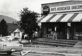
Ray's Associated Grocery
https://search.heritageburnaby.ca/link/archivedescription79086
- Repository
- City of Burnaby Archives
- Date
- September 5, 1976
- Collection/Fonds
- Burnaby Public Library Contemporary Visual Archive Project
- Description Level
- Item
- Physical Description
- 1 photograph : b&w ; 11 x 16 cm mounted on cardboard
- Scope and Content
- Photograph shows people going in and out of Ray's Associated Grocery at the corner of McGill Street and Gilmore Avenue.
- Repository
- City of Burnaby Archives
- Date
- September 5, 1976
- Collection/Fonds
- Burnaby Public Library Contemporary Visual Archive Project
- Physical Description
- 1 photograph : b&w ; 11 x 16 cm mounted on cardboard
- Description Level
- Item
- Record No.
- 556-143
- Access Restriction
- No restrictions
- Reproduction Restriction
- Reproduce for fair dealing purposes only
- Accession Number
- 2013-13
- Scope and Content
- Photograph shows people going in and out of Ray's Associated Grocery at the corner of McGill Street and Gilmore Avenue.
- Names
- Ray's Associated Grocery
- Media Type
- Photograph
- Notes
- Scope note taken directly from BPL photograph description.
- 1 b&w copy negative : 10 x 12.5 cm accompanying
- Photographers identified by surnames only: Carr and Vardeman
- Geographic Access
- McGill Street
- Gilmore Avenue
- Historic Neighbourhood
- Vancouver Heights (Historic Neighbourhood)
- Planning Study Area
- Burnaby Heights Area
Images


Royal Oak Grocery
https://search.heritageburnaby.ca/link/archivedescription79092
- Repository
- City of Burnaby Archives
- Date
- September 13, 1976
- Collection/Fonds
- Burnaby Public Library Contemporary Visual Archive Project
- Description Level
- Item
- Physical Description
- 1 photograph : b&w ; 11 x 16 cm mounted on cardboard
- Scope and Content
- Photograph shows Royal Oak Grocery located at 6537 Royal Oak Avenue. The store was built in approximately 1946 and has living quarters above.
- Repository
- City of Burnaby Archives
- Date
- September 13, 1976
- Collection/Fonds
- Burnaby Public Library Contemporary Visual Archive Project
- Physical Description
- 1 photograph : b&w ; 11 x 16 cm mounted on cardboard
- Description Level
- Item
- Record No.
- 556-146
- Access Restriction
- No restrictions
- Reproduction Restriction
- Reproduce for fair dealing purposes only
- Accession Number
- 2013-13
- Scope and Content
- Photograph shows Royal Oak Grocery located at 6537 Royal Oak Avenue. The store was built in approximately 1946 and has living quarters above.
- Names
- Royal Oak Grocery
- Media Type
- Photograph
- Photographer
- McCarron, John
- Notes
- Scope note taken directly from BPL photograph description.
- 1 b&w copy negative : 10 x 12.5 cm accompanying
- Geographic Access
- Royal Oak Avenue
- Street Address
- 6537 Royal Oak Avenue
- Historic Neighbourhood
- Central Park (Historic Neighbourhood)
- Planning Study Area
- Marlborough Area
Images


Royal Oak Grocery
https://search.heritageburnaby.ca/link/archivedescription79093
- Repository
- City of Burnaby Archives
- Date
- October 9, 1976
- Collection/Fonds
- Burnaby Public Library Contemporary Visual Archive Project
- Description Level
- Item
- Physical Description
- 1 photograph : b&w ; 11 x 16 cm mounted on cardboard
- Scope and Content
- Photograph shows a young child drinking milk outside the Royal Oak Grocery located at 6537 Royal Oak Avenue.
- Repository
- City of Burnaby Archives
- Date
- October 9, 1976
- Collection/Fonds
- Burnaby Public Library Contemporary Visual Archive Project
- Physical Description
- 1 photograph : b&w ; 11 x 16 cm mounted on cardboard
- Description Level
- Item
- Record No.
- 556-147
- Access Restriction
- No restrictions
- Reproduction Restriction
- Reproduce for fair dealing purposes only
- Accession Number
- 2013-13
- Scope and Content
- Photograph shows a young child drinking milk outside the Royal Oak Grocery located at 6537 Royal Oak Avenue.
- Names
- Royal Oak Grocery
- Media Type
- Photograph
- Photographer
- McCarron, John
- Notes
- Scope note taken directly from BPL photograph description.
- 1 b&w copy negative : 10 x 12.5 cm accompanying
- Geographic Access
- Royal Oak Avenue
- Street Address
- 6537 Royal Oak Avenue
- Historic Neighbourhood
- Central Park (Historic Neighbourhood)
- Planning Study Area
- Marlborough Area
Images

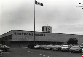
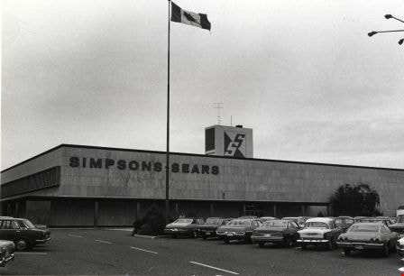
Simpson-Sears
https://search.heritageburnaby.ca/link/archivedescription79135
- Repository
- City of Burnaby Archives
- Date
- September 13, 1976
- Collection/Fonds
- Burnaby Public Library Contemporary Visual Archive Project
- Description Level
- Item
- Physical Description
- 1 photograph : b&w ; 11 x 16 cm mounted on cardboard
- Scope and Content
- Photograph shows Simpson-Sears store at 4750 Kingsway.
- Repository
- City of Burnaby Archives
- Date
- September 13, 1976
- Collection/Fonds
- Burnaby Public Library Contemporary Visual Archive Project
- Physical Description
- 1 photograph : b&w ; 11 x 16 cm mounted on cardboard
- Description Level
- Item
- Record No.
- 556-176
- Access Restriction
- No restrictions
- Reproduction Restriction
- Reproduce for fair dealing purposes only
- Accession Number
- 2013-13
- Scope and Content
- Photograph shows Simpson-Sears store at 4750 Kingsway.
- Subjects
- Buildings - Commercial - Stores
- Names
- Simpsons-Sears Limited
- Media Type
- Photograph
- Photographer
- McCarron, John
- Notes
- Scope note taken directly from BPL photograph description.
- 1 b&w copy negative : 10 x 12.5 cm accompanying
- Geographic Access
- Kingsway
- Street Address
- 4750 Kingsway
- Historic Neighbourhood
- Central Park (Historic Neighbourhood)
- Planning Study Area
- Maywood Area
Images

Tommy's Produce
https://search.heritageburnaby.ca/link/archivedescription79096
- Repository
- City of Burnaby Archives
- Date
- September 15, 1976
- Collection/Fonds
- Burnaby Public Library Contemporary Visual Archive Project
- Description Level
- Item
- Physical Description
- 1 photograph : b&w ; 11 x 16 cm mounted on cardboard
- Scope and Content
- Photograph shows Tommy's Produce at 4520 Kingsway between Willingdon and Cassie Avenue. The sign for the Dragon Inn can be seen in the background.
- Repository
- City of Burnaby Archives
- Date
- September 15, 1976
- Collection/Fonds
- Burnaby Public Library Contemporary Visual Archive Project
- Physical Description
- 1 photograph : b&w ; 11 x 16 cm mounted on cardboard
- Description Level
- Item
- Record No.
- 556-149
- Access Restriction
- No restrictions
- Reproduction Restriction
- Reproduce for fair dealing purposes only
- Accession Number
- 2013-13
- Scope and Content
- Photograph shows Tommy's Produce at 4520 Kingsway between Willingdon and Cassie Avenue. The sign for the Dragon Inn can be seen in the background.
- Names
- Tommy's Produce
- Media Type
- Photograph
- Photographer
- McCarron, John
- Notes
- Scope note taken directly from BPL photograph description.
- 1 b&w copy negative : 10 x 12.5 cm accompanying
- Geographic Access
- Kingsway
- Street Address
- 4520 Kingsway
- Historic Neighbourhood
- Central Park (Historic Neighbourhood)
- Planning Study Area
- Maywood Area
Images

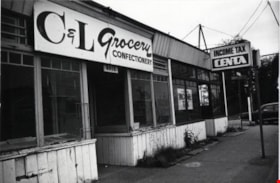
Vacant Stores at Kingsway and Griffiths
https://search.heritageburnaby.ca/link/archivedescription79089
- Repository
- City of Burnaby Archives
- Date
- September 22, 1976
- Collection/Fonds
- Burnaby Public Library Contemporary Visual Archive Project
- Description Level
- Item
- Physical Description
- 1 photograph : b&w ; 11 x 16 cm mounted on cardboard
- Scope and Content
- Photograph shows two vacant stores at the corner of Kingsway and Griffiths Avenue formerly occupied by C & L Grocery Confectionary at 6912 Kingsway and Centa Income Tax.
- Repository
- City of Burnaby Archives
- Date
- September 22, 1976
- Collection/Fonds
- Burnaby Public Library Contemporary Visual Archive Project
- Physical Description
- 1 photograph : b&w ; 11 x 16 cm mounted on cardboard
- Description Level
- Item
- Record No.
- 556-144
- Access Restriction
- No restrictions
- Reproduction Restriction
- Reproduce for fair dealing purposes only
- Accession Number
- 2013-13
- Scope and Content
- Photograph shows two vacant stores at the corner of Kingsway and Griffiths Avenue formerly occupied by C & L Grocery Confectionary at 6912 Kingsway and Centa Income Tax.
- Media Type
- Photograph
- Photographer
- Ross, Martha
- Notes
- Scope note taken directly from BPL photograph description.
- 1 b&w copy negative : 10 x 12.5 cm accompanying
- Geographic Access
- Kingsway
- Griffiths Avenue
- Street Address
- 6912 Kingsway
- Historic Neighbourhood
- Edmonds (Historic Neighbourhood)
- Planning Study Area
- Stride Avenue Area
Images
