More like 'Alfred Bingham's writings - Track 1'
Narrow Results By
![Burnaby Council, [1973] thumbnail](/media/hpo/_Data/_Archives_Images/_Unrestricted/204/204-804.jpg?width=280)
Burnaby Council
https://search.heritageburnaby.ca/link/archivedescription35944
- Repository
- City of Burnaby Archives
- Date
- [1973]
- Collection/Fonds
- Burnaby Historical Society fonds
- Description Level
- Item
- Physical Description
- 1 photograph : col. ; 12.7 x 17.8 cm
- Scope and Content
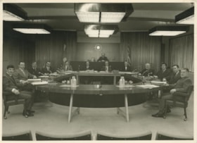
- Photograph of the Burnaby Council in chambers. The council members have nameplates in front of them.
- Repository
- City of Burnaby Archives
- Date
- [1973]
- Collection/Fonds
- Burnaby Historical Society fonds
- Subseries
- Pioneer Tales subseries
- Physical Description
- 1 photograph : col. ; 12.7 x 17.8 cm
- Description Level
- Item
- Record No.
- 204-804
- Access Restriction
- No restrictions
- Reproduction Restriction
- Reproduce for fair dealing purposes only
- Accession Number
- BHS1988-03
- Scope and Content
- Photograph of the Burnaby Council in chambers. The council members have nameplates in front of them.
- Subjects
- Officials - Alderman and Councillors
- Buildings - Civic - City Halls
- Officials - Mayors and Reeves
- Government - Local Government
- Names
- Blair, William A.
- Clark, Warren R.
- Constable, Thomas W. "Tom"
- Drummond, John D. "Doug"
- Gordon, Merrill
- Lawson, Doreen A.
- McLean, George H.F.
- Mercier, James L "Jim"
- Prittie, Robert W. "Bob"
- Burnaby City Hall
- Media Type
- Photograph
- Photographer
- Croton Studio Limited
- Notes
- Title based on contents of photograph
- Geographic Access
- Canada Way
- Street Address
- 4949 Canada Way
- Historic Neighbourhood
- Burnaby Lake (Historic Neighbourhood)
- Planning Study Area
- Douglas-Gilpin Area
Images
![Burnaby Council, [1973] thumbnail](/media/hpo/_Data/_Archives_Images/_Unrestricted/204/204-804.jpg)
Burnaby Municipal Council
https://search.heritageburnaby.ca/link/archivedescription55602
- Repository
- City of Burnaby Archives
- Date
- 1971
- Collection/Fonds
- John Shaw fonds
- Description Level
- Item
- Physical Description
- 1 photograph : b&w ; 12.5 x 17 cm
- Scope and Content
- Photograph is an official photograph of the Burnaby Municipal Council members, in the Council Chambers. From left to right (clockwise) around the table are: Hugh Ladner, Warren Clark, Jim Dailly, William Blair, Anthony Parr (Municipal Planner), Ted Ward (Deputy Municipal Clerk), Mayor Bob Prittie …
- Repository
- City of Burnaby Archives
- Date
- 1971
- Collection/Fonds
- John Shaw fonds
- Series
- Civil Service series
- Physical Description
- 1 photograph : b&w ; 12.5 x 17 cm
- Description Level
- Item
- Record No.
- 485-077
- Access Restriction
- No restrictions
- Reproduction Restriction
- Reproduce for fair dealing purposes only
- Accession Number
- 2005-15
- 2006-01
- 2007-18
- Scope and Content
- Photograph is an official photograph of the Burnaby Municipal Council members, in the Council Chambers. From left to right (clockwise) around the table are: Hugh Ladner, Warren Clark, Jim Dailly, William Blair, Anthony Parr (Municipal Planner), Ted Ward (Deputy Municipal Clerk), Mayor Bob Prittie (at the back), John Shaw (Municipal Clerk), Mel Shelley (Municipal Manager), George H.F. McLean, Dave Mercier, Alan Emmott, and Doug Drummond.
- Subjects
- Officials - Alderman and Councillors
- Buildings - Civic - City Halls
- Occupations - Civic Workers
- Names
- Ladner, Hugh G.
- Clark, Warren R.
- Dailly, James
- Blair, William A.
- Parr, Anthony L.
- Ward, Ted
- Shaw, John Horace "Jack"
- Prittie, Robert W. "Bob"
- Shelley, Melvin
- McLean, George H.F.
- Mercier, David M. "Dave"
- Emmott, Alan H.
- Drummond, John D. "Doug"
- Burnaby City Hall
- Media Type
- Photograph
- Photographer
- LeBlanc, Don
- Notes
- Title based on contents of photograph
- Note on verso reads: "1971 Council Corporation of Burnaby" and identifies the members of council
- Photographer's stamp on verso
- Photographer identifies photograph as no. 7143
- Geographic Access
- Canada Way
- Street Address
- 4949 Canada Way
- Historic Neighbourhood
- Burnaby Lake (Historic Neighbourhood)
- Planning Study Area
- Douglas-Gilpin Area
Images

Council discusses proposed Mosque
https://search.heritageburnaby.ca/link/archivedescription45426
- Repository
- City of Burnaby Archives
- Date
- April 18, 1978
- Collection/Fonds
- Columbian Newspaper collection
- Description Level
- Item
- Physical Description
- 1 photograph : b&w ; 9.5 x 18.5 cm
- Scope and Content
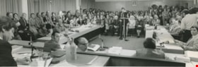
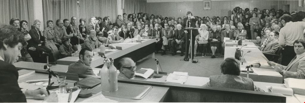
- Photograph of the council chambers overflowing with a crowd of people during a council meeting when the proposed Ismaili mosque was discussed.
- Repository
- City of Burnaby Archives
- Date
- April 18, 1978
- Collection/Fonds
- Columbian Newspaper collection
- Physical Description
- 1 photograph : b&w ; 9.5 x 18.5 cm
- Description Level
- Item
- Record No.
- 480-321
- Access Restriction
- No restrictions
- Reproduction Restriction
- Reproduce for fair dealing purposes only
- Accession Number
- 2003-02
- Scope and Content
- Photograph of the council chambers overflowing with a crowd of people during a council meeting when the proposed Ismaili mosque was discussed.
- Subjects
- Officials - Alderman and Councillors
- Buildings - Civic - City Halls
- Protests and Demonstrations
- Media Type
- Photograph
- Photographer
- Battistoni, Peter
- Notes
- Title based on contents of photograph
- Newspaper clipping attached to verso of photograph reads: "Crowd at hearing into proposed mosque overflowed council chambers and trailed down the stairs."
- Geographic Access
- Canada Way
- Street Address
- 4949 Canada Way
- Historic Neighbourhood
- Burnaby Lake (Historic Neighbourhood)
- Planning Study Area
- Douglas-Gilpin Area
Images
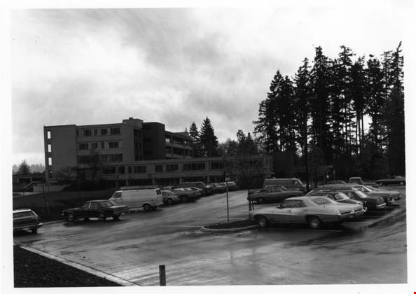
Burnaby Municipal Hall & Parking Lot
https://search.heritageburnaby.ca/link/archivedescription93635
- Repository
- City of Burnaby Archives
- Date
- October 26, 1977
- Collection/Fonds
- Burnaby Public Library Contemporary Visual Archive Project
- Description Level
- Item
- Physical Description
- 1 photograph : b&w ; 12.5 x 17.5 cm
- Scope and Content
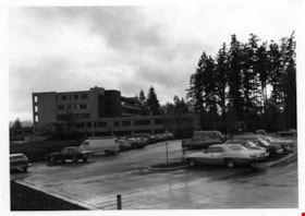
- Photograph of the side of the exterior of Burnaby Municipal Hall, with a parking lot in the foreground. The photograph is taken facing south.
- Repository
- City of Burnaby Archives
- Date
- October 26, 1977
- Collection/Fonds
- Burnaby Public Library Contemporary Visual Archive Project
- Physical Description
- 1 photograph : b&w ; 12.5 x 17.5 cm
- Description Level
- Item
- Record No.
- 556-592
- Access Restriction
- No restrictions
- Reproduction Restriction
- Reproduce for fair dealing purposes only
- Accession Number
- 2017-57
- Scope and Content
- Photograph of the side of the exterior of Burnaby Municipal Hall, with a parking lot in the foreground. The photograph is taken facing south.
- Names
- Burnaby City Hall
- Media Type
- Photograph
- Photographer
- Surridge, Jack
- Notes
- Title taken from project information form
- Accompanied by a project information form and 1 photograph (b&w negative ; 9.5 x 12.5 cm)
- BPL no. 41
- Street Address
- 4949 Canada Way
- Historic Neighbourhood
- Burnaby Lake (Historic Neighbourhood)
- Planning Study Area
- Douglas-Gilpin Area
Images

Crossing Royal Oak & Rumble Street
https://search.heritageburnaby.ca/link/archivedescription93686
- Repository
- City of Burnaby Archives
- Date
- May 19, 1978
- Collection/Fonds
- Burnaby Public Library Contemporary Visual Archive Project
- Description Level
- Item
- Physical Description
- 1 photograph : b&w ; 12.5 x 17.5 cm
- Scope and Content
- Photograph of the intersection of Royal Oak Avenue and Rumble Street. Cars and pedestrians are crossing the intersection, and the signs for businesses TD Bank, Standard Oil/Chevron gas station, Gulf gas station, and Baxter's Market are visible. The photograph is taken from a corner of the intersect…
- Repository
- City of Burnaby Archives
- Date
- May 19, 1978
- Collection/Fonds
- Burnaby Public Library Contemporary Visual Archive Project
- Physical Description
- 1 photograph : b&w ; 12.5 x 17.5 cm
- Description Level
- Item
- Record No.
- 556-643
- Access Restriction
- No restrictions
- Reproduction Restriction
- Reproduce for fair dealing purposes only
- Accession Number
- 2017-57
- Scope and Content
- Photograph of the intersection of Royal Oak Avenue and Rumble Street. Cars and pedestrians are crossing the intersection, and the signs for businesses TD Bank, Standard Oil/Chevron gas station, Gulf gas station, and Baxter's Market are visible. The photograph is taken from a corner of the intersection, facing southeast.
- Subjects
- Geographic Features - Roads
- Advertising Medium - Signs and Signboards
- Buildings - Commercial - Service Stations
- Transportation - Automobiles
- Buildings - Commercial
- Media Type
- Photograph
- Photographer
- van Mannen, Mark
- Notes
- Title taken from project information form
- Accompanied by a project information form and 1 photograph (b&w negative ; 9.5 x 12.5 cm)
- BPL no. 91
- Geographic Access
- Royal Oak Avenue
- Rumble Street
- Historic Neighbourhood
- Alta Vista (Historic Neighbourhood)
- Planning Study Area
- Sussex-Nelson Area
Images


Crossing Royal Oak & Rumble Street
https://search.heritageburnaby.ca/link/archivedescription93687
- Repository
- City of Burnaby Archives
- Date
- May 19, 1978
- Collection/Fonds
- Burnaby Public Library Contemporary Visual Archive Project
- Description Level
- Item
- Physical Description
- 1 photograph : b&w ; 12.5 x 17.5 cm
- Scope and Content
- Photograph of the intersection of Royal Oak Avenue and Rumble Street. Cars and pedestrians are crossing the intersection, and the signs for businesses Grace United Pharmacy, Standard Oil/Chevron gas station, Gulf gas station, and Royal Meats are visible. The photograph is taken from the Gulf gas st…
- Repository
- City of Burnaby Archives
- Date
- May 19, 1978
- Collection/Fonds
- Burnaby Public Library Contemporary Visual Archive Project
- Physical Description
- 1 photograph : b&w ; 12.5 x 17.5 cm
- Description Level
- Item
- Record No.
- 556-644
- Access Restriction
- No restrictions
- Reproduction Restriction
- Reproduce for fair dealing purposes only
- Accession Number
- 2017-57
- Scope and Content
- Photograph of the intersection of Royal Oak Avenue and Rumble Street. Cars and pedestrians are crossing the intersection, and the signs for businesses Grace United Pharmacy, Standard Oil/Chevron gas station, Gulf gas station, and Royal Meats are visible. The photograph is taken from the Gulf gas station parking lot, facing northwest.
- Subjects
- Advertising Medium - Signs and Signboards
- Geographic Features - Roads
- Transportation - Automobiles
- Buildings - Commercial
- Buildings - Commercial - Service Stations
- Media Type
- Photograph
- Photographer
- van Mannen, Mark
- Notes
- Title taken from project information form
- Accompanied by a project information form and 1 photograph (b&w negative ; 9.5 x 12.5 cm)
- BPL no. 92
- Geographic Access
- Royal Oak Avenue
- Rumble Street
- Historic Neighbourhood
- Alta Vista (Historic Neighbourhood)
- Planning Study Area
- Sussex-Nelson Area
Images

![Highway Improvement Project signage, [1972] thumbnail](/media/hpo/_Data/_Archives_Images/_Unrestricted/480/480-280.jpg?width=280)
Highway Improvement Project signage
https://search.heritageburnaby.ca/link/archivedescription45385
- Repository
- City of Burnaby Archives
- Date
- [1972]
- Collection/Fonds
- Columbian Newspaper collection
- Description Level
- Item
- Physical Description
- 1 photograph : b&w ; 14 x 21 cm
- Scope and Content
- Photograph of Highway Improvement Project signage (developed by the British Columbian Government under W.A.C. Bennett) along the Trans Canada Highway.
- Repository
- City of Burnaby Archives
- Date
- [1972]
- Collection/Fonds
- Columbian Newspaper collection
- Physical Description
- 1 photograph : b&w ; 14 x 21 cm
- Description Level
- Item
- Record No.
- 480-280
- Access Restriction
- No restrictions
- Reproduction Restriction
- No restrictions
- Accession Number
- 2003-02
- Scope and Content
- Photograph of Highway Improvement Project signage (developed by the British Columbian Government under W.A.C. Bennett) along the Trans Canada Highway.
- Media Type
- Photograph
- Photographer
- King, Basil
- Notes
- Title based on contents of photograph
Images
![Highway Improvement Project signage, [1972] thumbnail](/media/hpo/_Data/_Archives_Images/_Unrestricted/480/480-280.jpg)