Narrow Results By
Subject
- Animals - Horses 7
- Arts - Paintings 1
- Arts - Sculptures 3
- Buildings - Civic 1
- Buildings - Civic - Archives 3
- Buildings - Civic - Art Galleries 24
- Buildings - Civic - City Halls 1
- Buildings - Civic - Museums 17
- Buildings - Commercial - Banks 1
- Buildings - Commercial - Drugstores 1
- Buildings - Commercial - General Stores 1
- Buildings Components - Fireplaces 1

Burnaby Village Museum
https://search.heritageburnaby.ca/link/landmark808
- Repository
- Burnaby Heritage Planning
- Geographic Access
- Deer Lake Avenue
- Associated Dates
- 1971
- Heritage Value
- The Burnaby Village Museum is a ten-acre heritage site located adjacent to Deer Lake. The site was originally created as a B.C. Centennial Project in 1971. The official sod turning for was April 11, 1971 by the then Governor General of Canada Roland Mitchener. The Village was initially managed by the Century Park Museum Association, a volunteer society of Burnaby citizens. Over the years many heritage building which could not be maintained in their original locations have been moved to the museum. Today half of the buildings in the village are heritage structures and the remainder are reproductions. In 1990 the City of Burnaby assumed direct management of the Village, and the museum became part of the Parks, Recreation and Culture Department. Visitors can enjoy the shops on Hill Street, ride the Parker 119 Carousel, and climb aboard the Interurban 1223 tram.
- Historic Neighbourhood
- Burnaby Lake (Historic Neighbourhood)
- Planning Study Area
- Douglas-Gilpin Area
- Morley-Buckingham Area
- Street Address
- 6501 Deer Lake Avenue
- Street View URL
- Google Maps Street View
Images


Shadbolt Centre for the Arts
https://search.heritageburnaby.ca/link/landmark820
- Repository
- Burnaby Heritage Planning
- Geographic Access
- Deer Lake Avenue
- Associated Dates
- 1995
- Heritage Value
- The Shadbolt Centre for the Arts opened in 1995. The Shadbolt Centre was named after two Burnaby residents who dedicated a lifetime of support and cultivation of the arts locally, nationally and internationally. Doris and Jack Shadbolt resided in Burnaby for over 50 years until Jack's death in November 1998. Doris Shadbolt spent her life's work bringing the artist and the audience closer together through her writing and curatorial work. Jack Shadbolt was an internationally recognized Canadian painter. He was also an author and both received many awards including the Order of Canada. In keeping with the Shadbolts' generosity the arts, Jack Shadbolt donated two of his paintings to the Centre for permanent display.
- Historic Neighbourhood
- Burnaby Lake (Historic Neighbourhood)
- Planning Study Area
- Douglas-Gilpin Area
- Street Address
- 6450 Deer Lake Avenue
- Street View URL
- Google Maps Street View
Images

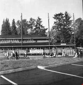
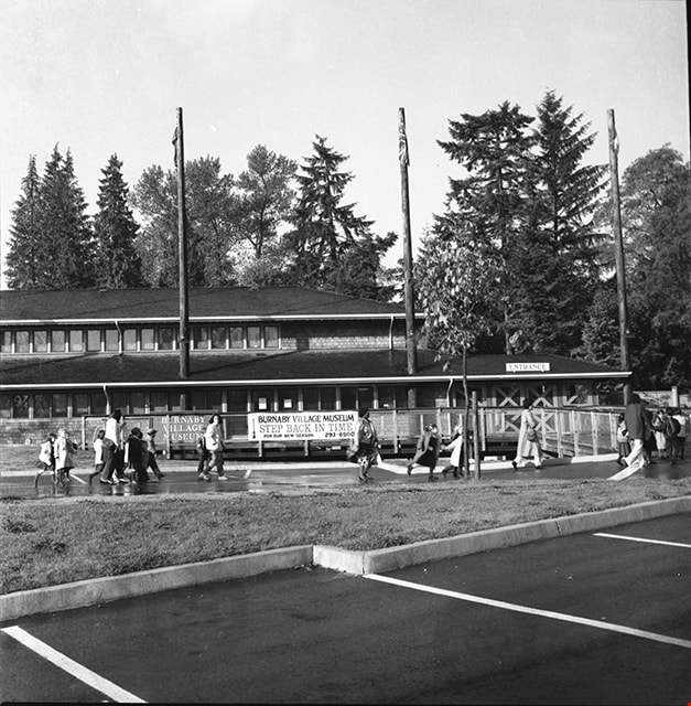
Adminstration building and entrance to Burnaby Village Museum
https://search.heritageburnaby.ca/link/museumdescription17505
- Repository
- Burnaby Village Museum
- Date
- 1990
- Collection/Fonds
- Burnaby Village Museum fonds
- Description Level
- Item
- Physical Description
- 1 photograph : b&w negative ; 6 x 6 cm
- Scope and Content
- Photograph of Burnaby Village Museum adminstration building, parking lot and entrance. A group of visitors are walking through the parking lot towards the entrance.
- Repository
- Burnaby Village Museum
- Collection/Fonds
- Burnaby Village Museum fonds
- Series
- Museum photographs series
- Description Level
- Item
- Physical Description
- 1 photograph : b&w negative ; 6 x 6 cm
- Scope and Content
- Photograph of Burnaby Village Museum adminstration building, parking lot and entrance. A group of visitors are walking through the parking lot towards the entrance.
- Names
- Burnaby Village Museum
- Geographic Access
- Deer Lake Avenue
- Street Address
- 6501 Deer Lake Avenue
- Accession Code
- BV019.2.66
- Access Restriction
- No restrictions
- Reproduction Restriction
- No known restrictions
- Date
- 1990
- Media Type
- Photograph
- Historic Neighbourhood
- Burnaby Lake (Historic Neighbourhood)
- Scan Resolution
- 1200
- Scan Date
- 2021-09-29
- Photographer
- Stevens, Colin
- Notes
- Title based on contents of photograph
- Photograph from negative roll "P90-19"
Images
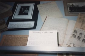
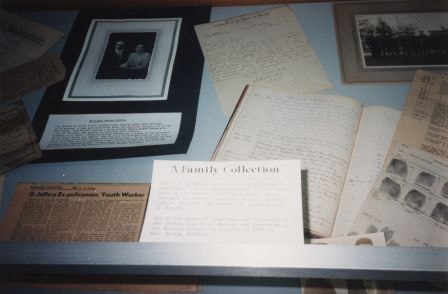
A Family Collection
https://search.heritageburnaby.ca/link/archivedescription36452
- Repository
- City of Burnaby Archives
- Date
- 1990
- Collection/Fonds
- Burnaby Historical Society fonds
- Description Level
- Item
- Physical Description
- 1 photograph : col. ; 10 x 15 cm
- Scope and Content
- Photograph of the George Jeffrey family collection on display during the opening of the Burnaby Community Archives at the Burnaby Village Museum.
- Repository
- City of Burnaby Archives
- Date
- 1990
- Collection/Fonds
- Burnaby Historical Society fonds
- Subseries
- Donald N. Brown subseries
- Physical Description
- 1 photograph : col. ; 10 x 15 cm
- Description Level
- Item
- Record No.
- 271-020
- Access Restriction
- No restrictions
- Reproduction Restriction
- Reproduce for fair dealing purposes only
- Accession Number
- BHS1991-41
- Scope and Content
- Photograph of the George Jeffrey family collection on display during the opening of the Burnaby Community Archives at the Burnaby Village Museum.
- Media Type
- Photograph
- Notes
- 1 col. negative accompanying
- Geographic Access
- Deer Lake Avenue
- Street Address
- 6501 Deer Lake Avenue
- Historic Neighbourhood
- Burnaby Lake (Historic Neighbourhood)
- Planning Study Area
- Morley-Buckingham Area
Images
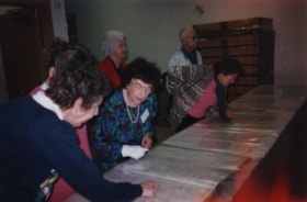
Archivist Pixie McGeachie
https://search.heritageburnaby.ca/link/archivedescription36448
- Repository
- City of Burnaby Archives
- Date
- 1990
- Collection/Fonds
- Burnaby Historical Society fonds
- Description Level
- Item
- Physical Description
- 1 photograph : col. ; 10 x 15 cm
- Scope and Content
- Photograph of archivist Pixie McGeachie showing onlookers community records inside the storage area during the opening of the Burnaby Community Archives at the Burnaby Village Museum.
- Repository
- City of Burnaby Archives
- Date
- 1990
- Collection/Fonds
- Burnaby Historical Society fonds
- Subseries
- Donald N. Brown subseries
- Physical Description
- 1 photograph : col. ; 10 x 15 cm
- Description Level
- Item
- Record No.
- 271-016
- Access Restriction
- No restrictions
- Reproduction Restriction
- Reproduce for fair dealing purposes only
- Accession Number
- BHS1991-41
- Scope and Content
- Photograph of archivist Pixie McGeachie showing onlookers community records inside the storage area during the opening of the Burnaby Community Archives at the Burnaby Village Museum.
- Subjects
- Events - Openings
- Media Type
- Photograph
- Notes
- Title based on contents of photograph
- 1 photograph : col. negative ; 35 mm accompanying
- Geographic Access
- Deer Lake Avenue
- Street Address
- 6501 Deer Lake Avenue
- Historic Neighbourhood
- Burnaby Lake (Historic Neighbourhood)
- Planning Study Area
- Morley-Buckingham Area
Images


Art Gallery
https://search.heritageburnaby.ca/link/archivedescription93607
- Repository
- City of Burnaby Archives
- Date
- October 16, 1977
- Collection/Fonds
- Burnaby Public Library Contemporary Visual Archive Project
- Description Level
- Item
- Physical Description
- 1 photograph : b&w ; 12.5 x 17.5 cm
- Scope and Content
- Photograph of the front exterior of the Burnaby Art Gallery (Ceperley/Fairacres) and Century Gardens. The photograph is taken from a garden path, facing northwest.
- Repository
- City of Burnaby Archives
- Date
- October 16, 1977
- Collection/Fonds
- Burnaby Public Library Contemporary Visual Archive Project
- Physical Description
- 1 photograph : b&w ; 12.5 x 17.5 cm
- Description Level
- Item
- Record No.
- 556-564
- Access Restriction
- No restrictions
- Reproduction Restriction
- Reproduce for fair dealing purposes only
- Accession Number
- 2017-57
- Scope and Content
- Photograph of the front exterior of the Burnaby Art Gallery (Ceperley/Fairacres) and Century Gardens. The photograph is taken from a garden path, facing northwest.
- Names
- Burnaby Art Gallery
- Media Type
- Photograph
- Photographer
- Chapman, Fred
- Notes
- Title taken from project information form
- Accompanied by a project information form and 1 photograph (b&w negative ; 9.5 x 12.5 cm)
- BPL no. 8
- Geographic Access
- Deer Lake Avenue
- Street Address
- 6344 Deer Lake Avenue
- Historic Neighbourhood
- Burnaby Lake (Historic Neighbourhood)
- Planning Study Area
- Douglas-Gilpin Area
Images


Art Gallery
https://search.heritageburnaby.ca/link/archivedescription93608
- Repository
- City of Burnaby Archives
- Date
- October 16, 1977
- Collection/Fonds
- Burnaby Public Library Contemporary Visual Archive Project
- Description Level
- Item
- Physical Description
- 1 photograph : b&w ; 12.5 x 17.5 cm
- Scope and Content
- Photograph of the rear exterior of the Burnaby Art Gallery (Ceperley/Fairacres). The photograph is taken from a parking lot, facing east, and shows the entrance to the Art Gallery.
- Repository
- City of Burnaby Archives
- Date
- October 16, 1977
- Collection/Fonds
- Burnaby Public Library Contemporary Visual Archive Project
- Physical Description
- 1 photograph : b&w ; 12.5 x 17.5 cm
- Description Level
- Item
- Record No.
- 556-565
- Access Restriction
- No restrictions
- Reproduction Restriction
- Reproduce for fair dealing purposes only
- Accession Number
- 2017-57
- Scope and Content
- Photograph of the rear exterior of the Burnaby Art Gallery (Ceperley/Fairacres). The photograph is taken from a parking lot, facing east, and shows the entrance to the Art Gallery.
- Names
- Burnaby Art Gallery
- Media Type
- Photograph
- Photographer
- Chapman, Fred
- Notes
- Title taken from project information form
- Accompanied by a project information form and 1 photograph (b&w negative ; 9.5 x 12.5 cm)
- BPL no. 9
- Geographic Access
- Deer Lake Avenue
- Street Address
- 6344 Deer Lake Avenue
- Historic Neighbourhood
- Burnaby Lake (Historic Neighbourhood)
- Planning Study Area
- Douglas-Gilpin Area
Images


Bird's Eye View of the Burnaby Lake Area
https://search.heritageburnaby.ca/link/museumdescription15144
- Repository
- Burnaby Village Museum
- Date
- 1977
- Collection/Fonds
- Century Park Museum Association fonds
- Description Level
- Item
- Physical Description
- 1 map : b&w print on paper ; 43 x 63.5 cm
- Scope and Content
- Item consists of a map titled "Birds Eye View of the Burnaby Lake Area Circa 1910". The overview of the Burnaby Lake area was compiled and drawn at Heritage Village by curator John Adams and artist, Carol Swan. The map identifies the Burnaby Lake inter-urban tram line; roads including: Sperling Ave…
- Repository
- Burnaby Village Museum
- Collection/Fonds
- Century Park Museum Association fonds
- Description Level
- Item
- Physical Description
- 1 map : b&w print on paper ; 43 x 63.5 cm
- Material Details
- Scale indeterminable
- Scope and Content
- Item consists of a map titled "Birds Eye View of the Burnaby Lake Area Circa 1910". The overview of the Burnaby Lake area was compiled and drawn at Heritage Village by curator John Adams and artist, Carol Swan. The map identifies the Burnaby Lake inter-urban tram line; roads including: Sperling Avenue (Pole Line Road); Gilpin Avenue; Douglas Road; trail to Vancouver Westminster Road (Kingsway); Buckingham Avenue; Haszard Street; various farms and residences including: Charles Sprott "Norland"; H.T. Ceperley "Fairacres"; Claude Hill's "Brookfield farm" and "Broadview"; F.J. Hart's "Avalon"; Miss Woodward's former and new home, school and post office; Councillor Edgar's hunting cabin; Edgar Sprott's "Mayfield farm" and "Mayfield Lodge"; F.J. Peers "Greyfriars"; Arthur de Windt Haszard; Bernard Hill's boathouse as well as other landmarks including: Doran's Mill; tram stations; Burnaby Lake Store; logging camps; wood cutter's shacks; ice houses; cranberry bog; Still Creek; Deer Lake; Burnaby Lake; Deer Lake Creek; Provincial Government Reserve Proposed Hospital (later Oakalla Prison).
- Creator
- Adams, John
- Swan, Carol
- Names
- Hill, Arthur Claude
- Sprott, Charles Frederick
- Sprott, Louis "Edgar"
- Hart, Frederick John, 1884-1945
- Ceperley, H.T.
- Woodward, Maude
- Woodward, Harriet
- Peers, Francis J.
- Haszard, Arthur de Windt
- Hill, Bernard R.
- Geographic Access
- Deer Lake Avenue
- Sperling Avenue
- Haszard Street
- Buckingham Avenue
- Accession Code
- BV021.1.3
- Access Restriction
- No restrictions
- Reproduction Restriction
- No known restrictions
- Date
- 1977
- Media Type
- Cartographic Material
- Historic Neighbourhood
- Burnaby Lake (Historic Neighbourhood)
- Planning Study Area
- Burnaby Lake Area
- Related Material
- See also: Life with the Moores of Hart House : pioneer days on Burnaby's Deer Lake
- Scan Resolution
- 600
- Scan Date
- 2021-11-12
- Scale
- 100
- Notes
- Transcribed title
- Compiled by John Adams; illustration by Carol Swan
- The map depicts the Burnaby Lake Tram Line as being double tracked, whereas in reality it was single tracked.
- Map is part of the book "Life with the Moores of Hart House : pioneer days on Burnaby's Deer Lake https://search.heritageburnaby.ca/permalink/museumlibrary6314-102
Images


Bird's Eye View of the Burnaby Lake Area
https://search.heritageburnaby.ca/link/museumdescription17543
- Repository
- Burnaby Village Museum
- Date
- 1977
- Collection/Fonds
- Century Park Museum Association fonds
- Description Level
- Item
- Physical Description
- 1 map : b&w print with watercolour ; 43 x 63.5 cm
- Scope and Content
- Item consists of a map titled "Birds Eye View of the Burnaby Lake Area Circa 1910". The overview of the Burnaby Lake area was compiled and drawn at Heritage Village by curator John Adams and artist, Carol Swan. The map identifies the Burnaby Lake inter-urban tram line; roads including: Sperling Ave…
- Repository
- Burnaby Village Museum
- Collection/Fonds
- Century Park Museum Association fonds
- Description Level
- Item
- Physical Description
- 1 map : b&w print with watercolour ; 43 x 63.5 cm
- Material Details
- Scale indeterminable
- Scope and Content
- Item consists of a map titled "Birds Eye View of the Burnaby Lake Area Circa 1910". The overview of the Burnaby Lake area was compiled and drawn at Heritage Village by curator John Adams and artist, Carol Swan. The map identifies the Burnaby Lake inter-urban tram line; roads including: Sperling Avenue (Pole Line Road); Gilpin Avenue; Douglas Road; trail to Vancouver Westminster Road (Kingsway); Buckingham Avenue; Haszard Street; various farms and residences including: Charles Sprott "Norland"; H.T. Ceperley "Fairacres"; Claude Hill's "Brookfield farm" and "Broadview"; F.J. Hart's "Avalon"; Miss Woodward's former and new home, school and post office; Councillor Edgar's hunting cabin; Edgar Sprott's "Mayfield farm" and "Mayfield Lodge"; F.J. Peers "Greyfriars"; Arthur de Windt Haszard; Bernard Hill's boathouse as well as other landmarks including: Doran's Mill; tram stations; Burnaby Lake Store; logging camps; wood cutter's shacks; ice houses; cranberry bog; Still Creek; Deer Lake; Burnaby Lake; Deer Lake Creek; Provincial Government Reserve Proposed Hospital (later Oakalla Prison).
- Creator
- Adams, John
- Swan, Carol
- Names
- Hill, Arthur Claude
- Sprott, Charles Frederick
- Sprott, Louis "Edgar"
- Hart, Frederick John, 1884-1945
- Ceperley, H.T.
- Woodward, Maude
- Woodward, Harriet
- Peers, Francis J.
- Haszard, Arthur de Windt
- Hill, Bernard R.
- Geographic Access
- Deer Lake Avenue
- Sperling Avenue
- Haszard Street
- Buckingham Avenue
- Accession Code
- BV021.1.4
- Access Restriction
- No restrictions
- Reproduction Restriction
- No known restrictions
- Date
- 1977
- Media Type
- Cartographic Material
- Historic Neighbourhood
- Burnaby Lake (Historic Neighbourhood)
- Planning Study Area
- Burnaby Lake Area
- Related Material
- See also: Life with the Moores of Hart House : pioneer days on Burnaby's Deer Lake
- Scan Resolution
- 600
- Scan Date
- 2021-11-12
- Scale
- 100
- Notes
- Transcribed title
- Compiled by John Adams; illustration by Carol Swan
- The map depicts the Burnaby Lake Tram Line as being double tracked, whereas in reality it was single tracked.
- Map is part of the book "Life with the Moores of Hart House : pioneer days on Burnaby's Deer Lake https://search.heritageburnaby.ca/permalink/museumlibrary6314-102
- This is a print made from original illustration and appears to be hand-coloured with watercolour at a later date.
Images

![Blacksmith shop inside Heritage Village, [between Dec. 1971 and Jan. 1972] thumbnail](/media/hpo/_Data/_BVM_Images//2022/2022_0009_0027_001.jpg?width=280)
Blacksmith shop inside Heritage Village
https://search.heritageburnaby.ca/link/museumdescription18477
- Repository
- Burnaby Village Museum
- Date
- [between Dec. 1971 and Jan. 1972]
- Collection/Fonds
- Century Park Museum Association fonds
- Description Level
- Item
- Physical Description
- 1 photograph : col. slide ; 35 mm
- Scope and Content
- Photograph of the Blacksmith shop inside Heritage Village located at the south end of Hill Street. The ground and rooftop is covered with snow.
- Repository
- Burnaby Village Museum
- Collection/Fonds
- Century Park Museum Association fonds
- Description Level
- Item
- Physical Description
- 1 photograph : col. slide ; 35 mm
- Scope and Content
- Photograph of the Blacksmith shop inside Heritage Village located at the south end of Hill Street. The ground and rooftop is covered with snow.
- Subjects
- Natural Phenomena - Snow
- Names
- Burnaby Village Museum
- Geographic Access
- Deer Lake Avenue
- Accession Code
- BV022.9.27
- Access Restriction
- No restrictions
- Reproduction Restriction
- No known restrictions
- Date
- [between Dec. 1971 and Jan. 1972]
- Media Type
- Photograph
- Photographer
- Lott, Richard
- Notes
- Title based on contents of photograph
Images
![Blacksmith shop inside Heritage Village, [between Dec. 1971 and Jan. 1972] thumbnail](/media/hpo/_Data/_BVM_Images//2022/2022_0009_0027_001.jpg)
![Brookfield house and yard of Elworth house, [1970] thumbnail](/media/hpo/_Data/_BVM_Images//2022/2022_0009_0012_001.jpg?width=280)
Brookfield house and yard of Elworth house
https://search.heritageburnaby.ca/link/museumdescription18460
- Repository
- Burnaby Village Museum
- Date
- [1970]
- Collection/Fonds
- Burnaby Centennial '71 Committee collection
- Description Level
- Item
- Physical Description
- 1 photograph : b&w ; 9 x 12.5 cm
- Scope and Content
- Photograph of yard of Elworth house in foreground with garage and white stucco house in background identified as "Brookfield". "Brookfield" house was the former residence of Louis Claude and Annie Hill [1895-1906]. Sometime after the Hills moved out, the original one story house was renovated with …
- Repository
- Burnaby Village Museum
- Collection/Fonds
- Burnaby Centennial '71 Committee collection
- Description Level
- Item
- Physical Description
- 1 photograph : b&w ; 9 x 12.5 cm
- Scope and Content
- Photograph of yard of Elworth house in foreground with garage and white stucco house in background identified as "Brookfield". "Brookfield" house was the former residence of Louis Claude and Annie Hill [1895-1906]. Sometime after the Hills moved out, the original one story house was renovated with a basement and second story dormers added. The Waplingtons lived in the house (1926-1947) and the Flemings (1947-1958). Dowad is noted as owning the property when it was acquired for the site of Heritage Village in 1971 and the house was demolished. The address for Brookfield house was 5016 Deer Lake Avenue (1958-1971) and 3813 Deer Lake Avenue (1926-1958). The address for Elworth house in 1970 was 4950 Deer Lake Avenue. Elworth house was acquired as an integral part of the Heritage Village Museum which opened in November 1971.
- Geographic Access
- Deer Lake Avenue
- Accession Code
- BV022.9.12
- Access Restriction
- No restrictions
- Reproduction Restriction
- No known restrictions
- Date
- [1970]
- Media Type
- Photograph
- Scan Resolution
- 600
- Scan Date
- 2022-03-15
- Photographer
- Lott, Richard
- Notes
- Title based on contents of photograph
- Handwritten note in blue ink on verso of photograph reads: "1970 / Bby H Village / site"
- Stamp in black ink on verso of photograph reads: "N2194 / 19.2.71"
Images
![Brookfield house and yard of Elworth house, [1970] thumbnail](/media/hpo/_Data/_BVM_Images//2022/2022_0009_0012_001.jpg)
![Brookfield house prior to demolition, [1970] thumbnail](/media/hpo/_Data/_BVM_Images//2022/2022_0009_0007_001.jpg?width=280)
Brookfield house prior to demolition
https://search.heritageburnaby.ca/link/museumdescription18457
- Repository
- Burnaby Village Museum
- Date
- [1970]
- Collection/Fonds
- Burnaby Centennial '71 Committee collection
- Description Level
- Item
- Physical Description
- 1 photograph : b&w ; 9 x 12.5 cm
- Scope and Content
- Photograph of white stucco house and front yard identified as "Brookfield" the former residence of Louis Claude and Annie Hill [1895-1906]. Sometime after the Hills moved out, the original one story house was renovated with a basement and second story dormers added. The Waplingtons lived in the hou…
- Repository
- Burnaby Village Museum
- Collection/Fonds
- Burnaby Centennial '71 Committee collection
- Description Level
- Item
- Physical Description
- 1 photograph : b&w ; 9 x 12.5 cm
- Scope and Content
- Photograph of white stucco house and front yard identified as "Brookfield" the former residence of Louis Claude and Annie Hill [1895-1906]. Sometime after the Hills moved out, the original one story house was renovated with a basement and second story dormers added. The Waplingtons lived in the house (1926-1947) and the Flemings (1947-1958). Dowad is noted as owning the property when it was acquired for the site of Heritage Village in 1971 and the house was demolished. The address for the house was 5016 Deer Lake Avenue (1958-1971) and 3813 Deer Lake Avenue (1926-1958). Elworth house is visible in the background to the right.
- Geographic Access
- Deer Lake Avenue
- Street Address
- 5016 Deer Lake Avenue
- Accession Code
- BV022.9.7
- Access Restriction
- No restrictions
- Reproduction Restriction
- No known restrictions
- Date
- [1970]
- Media Type
- Photograph
- Scan Resolution
- 600
- Scan Date
- 2022-03-15
- Photographer
- Lott, Richard
- Notes
- Title based on contents of photograph
- Handwritten note in blue ink on verso of photograph reads: "Dowad house / 1970"
- Stamp in black ink on verso of photograph reads: "N2194 / 19.2.71"
Images
![Brookfield house prior to demolition, [1970] thumbnail](/media/hpo/_Data/_BVM_Images//2022/2022_0009_0007_001.jpg)
![Brookfield house prior to demolition, [1970] thumbnail](/media/hpo/_Data/_BVM_Images//2022/2022_0009_0009_001.jpg?width=280)
Brookfield house prior to demolition
https://search.heritageburnaby.ca/link/museumdescription18458
- Repository
- Burnaby Village Museum
- Date
- [1970]
- Collection/Fonds
- Burnaby Centennial '71 Committee collection
- Description Level
- Item
- Physical Description
- 1 photograph : b&w ; 9 x 12.5 cm
- Scope and Content
- Photograph of white stucco house identified as "Brookfield" the former residence of Louis Claude and Annie Hill [1895-1906]. Sometime after the Hills moved out, the original one story house was renovated with a basement and second story dormers added. The Waplingtons lived in the house (1926-1947) …
- Repository
- Burnaby Village Museum
- Collection/Fonds
- Burnaby Centennial '71 Committee collection
- Description Level
- Item
- Physical Description
- 1 photograph : b&w ; 9 x 12.5 cm
- Scope and Content
- Photograph of white stucco house identified as "Brookfield" the former residence of Louis Claude and Annie Hill [1895-1906]. Sometime after the Hills moved out, the original one story house was renovated with a basement and second story dormers added. The Waplingtons lived in the house (1926-1947) and the Flemings (1947-1958). Dowad is noted as owning the property when it was acquired for the site of Heritage Village in 1971 and the house was demolished. The address for the house was 5016 Deer Lake Avenue (1958-1971) and 3813 Deer Lake Avenue (1926-1958). Elworth house is visible in the background to the right.
- Geographic Access
- Deer Lake Avenue
- Street Address
- 5016 Deer Lake Avenue
- Accession Code
- BV022.9.9
- Access Restriction
- No restrictions
- Reproduction Restriction
- No known restrictions
- Date
- [1970]
- Media Type
- Photograph
- Scan Resolution
- 600
- Scan Date
- 2022-03-15
- Photographer
- Lott, Richard
- Notes
- Title based on contents of photograph
- Handwritten note in blue ink on verso of photograph reads: "Dowad house / 1970"
- Stamp in black ink on verso of photograph reads: "N2194 / 19.2.71"
Images
![Brookfield house prior to demolition, [1970] thumbnail](/media/hpo/_Data/_BVM_Images//2022/2022_0009_0009_001.jpg)
![Brookfield house prior to demolition, [1970] thumbnail](/media/hpo/_Data/_BVM_Images//2022/2022_0009_0011_001.jpg?width=280)
Brookfield house prior to demolition
https://search.heritageburnaby.ca/link/museumdescription18459
- Repository
- Burnaby Village Museum
- Date
- [1970]
- Collection/Fonds
- Burnaby Centennial '71 Committee collection
- Description Level
- Item
- Physical Description
- 1 photograph : b&w ; 9 x 12.5 cm
- Scope and Content
- Photograph of white stucco house and front yard identified as "Brookfield" the former residence of Louis Claude and Annie Hill [1895-1906]. Sometime after the Hills moved out, the original one story house was renovated with a basement and second story dormers added. The Waplingtons lived in the hou…
- Repository
- Burnaby Village Museum
- Collection/Fonds
- Burnaby Centennial '71 Committee collection
- Description Level
- Item
- Physical Description
- 1 photograph : b&w ; 9 x 12.5 cm
- Scope and Content
- Photograph of white stucco house and front yard identified as "Brookfield" the former residence of Louis Claude and Annie Hill [1895-1906]. Sometime after the Hills moved out, the original one story house was renovated with a basement and second story dormers added. The Waplingtons lived in the house (1926-1947) and the Flemings (1947-1958). Dowad is noted as owning the property when it was acquired for the site of Heritage Village in 1971 and the house was demolished. The address for the house was 5016 Deer Lake Avenue (1958-1971) and 3813 Deer Lake Avenue (1926-1958). Elworth house and garage are visible in the background to the right.
- Geographic Access
- Deer Lake Avenue
- Street Address
- 5016 Deer Lake Avenue
- Accession Code
- BV022.9.11
- Access Restriction
- No restrictions
- Reproduction Restriction
- No known restrictions
- Date
- [1970]
- Media Type
- Photograph
- Scan Resolution
- 600
- Scan Date
- 2022-03-15
- Photographer
- Lott, Richard
- Notes
- Title based on contents of photograph
- Handwritten note in blue ink on verso of photograph reads: "Bby H Village site / 1970"
- Stamp in black ink on verso of photograph reads: "N2194 / 19.2.71"
Images
![Brookfield house prior to demolition, [1970] thumbnail](/media/hpo/_Data/_BVM_Images//2022/2022_0009_0011_001.jpg)
![Brookfield house prior to demolition, [1970] thumbnail](/media/hpo/_Data/_BVM_Images//2022/2022_0009_0017_001.jpg?width=280)
Brookfield house prior to demolition
https://search.heritageburnaby.ca/link/museumdescription18466
- Repository
- Burnaby Village Museum
- Date
- [1970]
- Collection/Fonds
- Burnaby Centennial '71 Committee collection
- Description Level
- Item
- Physical Description
- 1 photograph : b&w ; 9 x 12.5 cm
- Scope and Content
- Photograph of white stucco house identified as "Brookfield" the former residence of Louis Claude and Annie Hill [1895-1906]. Sometime after the Hills moved out, the original one story house was renovated with a basement and second story dormers added. The Waplingtons lived in the house (1926-1947) …
- Repository
- Burnaby Village Museum
- Collection/Fonds
- Burnaby Centennial '71 Committee collection
- Description Level
- Item
- Physical Description
- 1 photograph : b&w ; 9 x 12.5 cm
- Scope and Content
- Photograph of white stucco house identified as "Brookfield" the former residence of Louis Claude and Annie Hill [1895-1906]. Sometime after the Hills moved out, the original one story house was renovated with a basement and second story dormers added. The Waplingtons lived in the house (1926-1947) and the Flemings (1947-1958). Dowad is noted as owning the property when it was acquired for the site of Heritage Village in 1971 and the house was demolished. The address for the house was 5016 Deer Lake Avenue (1958-1971) and 3813 Deer Lake Avenue (1926-1958). Elworth house is visible in the background to the right.
- Geographic Access
- Deer Lake Avenue
- Street Address
- 5016 Deer Lake Avenue
- Accession Code
- BV022.9.17
- Access Restriction
- No restrictions
- Reproduction Restriction
- No known restrictions
- Date
- [1970]
- Media Type
- Photograph
- Scan Resolution
- 600
- Scan Date
- 2022-03-15
- Photographer
- Lott, Richard
- Notes
- Title based on contents of photograph
- Handwritten note in blue ink on verso of photograph reads: "Bby Museum site / Dowad house (crossed out) / 1970"
- Stamp in black ink on verso of photograph reads: "N2194 / 19.2.71"
Images
![Brookfield house prior to demolition, [1970] thumbnail](/media/hpo/_Data/_BVM_Images//2022/2022_0009_0017_001.jpg)
![Building on the northwest corner of Hill Street, [between Dec. 1971 and Jan. 1972] thumbnail](/media/hpo/_Data/_BVM_Images//2022/2022_0009_0023_001.jpg?width=280)
Building on the northwest corner of Hill Street
https://search.heritageburnaby.ca/link/museumdescription18472
- Repository
- Burnaby Village Museum
- Date
- [between Dec. 1971 and Jan. 1972]
- Collection/Fonds
- Century Park Museum Association fonds
- Description Level
- Item
- Physical Description
- 1 photograph : col. slide ; 35 mm
- Scope and Content
- Photograph of building on the northwest corner of Hill Street inside Heritage Village. Entrance to the left held the Real Estate Loans and Insurance window display and the entrance to the right held the Jail House window display. The ground and rooftops are covered with snow.
- Repository
- Burnaby Village Museum
- Collection/Fonds
- Century Park Museum Association fonds
- Description Level
- Item
- Physical Description
- 1 photograph : col. slide ; 35 mm
- Scope and Content
- Photograph of building on the northwest corner of Hill Street inside Heritage Village. Entrance to the left held the Real Estate Loans and Insurance window display and the entrance to the right held the Jail House window display. The ground and rooftops are covered with snow.
- Subjects
- Natural Phenomena - Snow
- Names
- Burnaby Village Museum
- Geographic Access
- Deer Lake Avenue
- Accession Code
- BV022.9.23
- Access Restriction
- No restrictions
- Reproduction Restriction
- No known restrictions
- Date
- [between Dec. 1971 and Jan. 1972]
- Media Type
- Photograph
- Photographer
- Lott, Richard
- Notes
- Title based on contents of photograph
Images
![Building on the northwest corner of Hill Street, [between Dec. 1971 and Jan. 1972] thumbnail](/media/hpo/_Data/_BVM_Images//2022/2022_0009_0023_001.jpg)
![Buildings along the east side of Hill Street, [between Dec. 1971 and Jan. 1972] thumbnail](/media/hpo/_Data/_BVM_Images//2022/2022_0009_0021_001.jpg?width=280)
Buildings along the east side of Hill Street
https://search.heritageburnaby.ca/link/museumdescription18470
- Repository
- Burnaby Village Museum
- Date
- [between Dec. 1971 and Jan. 1972]
- Collection/Fonds
- Century Park Museum Association fonds
- Description Level
- Item
- Physical Description
- 1 photograph : col. slide ; 35 mm
- Scope and Content
- Photograph of buildings along the east side of Hill Street on the site of Heritage Village Museum. Buildings left to right include, the Ice Cream Parlour, the Chinese Importers window display, Pharmacy and The News and Art Printing shop. The ground is covered with snow and there is a chain link fen…
- Repository
- Burnaby Village Museum
- Collection/Fonds
- Century Park Museum Association fonds
- Description Level
- Item
- Physical Description
- 1 photograph : col. slide ; 35 mm
- Scope and Content
- Photograph of buildings along the east side of Hill Street on the site of Heritage Village Museum. Buildings left to right include, the Ice Cream Parlour, the Chinese Importers window display, Pharmacy and The News and Art Printing shop. The ground is covered with snow and there is a chain link fence at the end of the street.
- Subjects
- Natural Phenomena - Snow
- Names
- Burnaby Village Museum
- Geographic Access
- Deer Lake Avenue
- Accession Code
- BV022.9.21
- Access Restriction
- No restrictions
- Reproduction Restriction
- No known restrictions
- Date
- [between Dec. 1971 and Jan. 1972]
- Media Type
- Photograph
- Photographer
- Lott, Richard
- Notes
- Title based on contents of photograph
Images
![Buildings along the east side of Hill Street, [between Dec. 1971 and Jan. 1972] thumbnail](/media/hpo/_Data/_BVM_Images//2022/2022_0009_0021_001.jpg)
![Buildings along the west side of Hill Street and Elworth, [between Dec. 1971 and Jan. 1972] thumbnail](/media/hpo/_Data/_BVM_Images//2022/2022_0009_0030_001.jpg?width=280)
Buildings along the west side of Hill Street and Elworth
https://search.heritageburnaby.ca/link/museumdescription18480
- Repository
- Burnaby Village Museum
- Date
- [between Dec. 1971 and Jan. 1972]
- Collection/Fonds
- Century Park Museum Association fonds
- Description Level
- Item
- Physical Description
- 1 photograph : col. slide ; 35 mm
- Scope and Content
- Photograph of buildings located on the west side of Hill Street and Elworth house at the north end of the street inside Heritage Village. Buildings from left to right; the General Supply Store Hardware, Real Estate Loans Insurance building and Elworth house. The ground and rooftops are covered wit…
- Repository
- Burnaby Village Museum
- Collection/Fonds
- Century Park Museum Association fonds
- Description Level
- Item
- Physical Description
- 1 photograph : col. slide ; 35 mm
- Scope and Content
- Photograph of buildings located on the west side of Hill Street and Elworth house at the north end of the street inside Heritage Village. Buildings from left to right; the General Supply Store Hardware, Real Estate Loans Insurance building and Elworth house. The ground and rooftops are covered with snow.
- Subjects
- Natural Phenomena - Snow
- Names
- Burnaby Village Museum
- Geographic Access
- Deer Lake Avenue
- Accession Code
- BV022.9.30
- Access Restriction
- No restrictions
- Reproduction Restriction
- No known restrictions
- Date
- [between Dec. 1971 and Jan. 1972]
- Media Type
- Photograph
- Photographer
- Lott, Richard
- Notes
- Title based on contents of photograph
Images
![Buildings along the west side of Hill Street and Elworth, [between Dec. 1971 and Jan. 1972] thumbnail](/media/hpo/_Data/_BVM_Images//2022/2022_0009_0030_001.jpg)
![Burnaby Art Gallery, [1999] thumbnail](/media/hpo/_Data/_Archives_Images/_Unrestricted/535/535-3355.jpg?width=280)
Burnaby Art Gallery
https://search.heritageburnaby.ca/link/archivedescription98345
- Repository
- City of Burnaby Archives
- Date
- [1999]
- Collection/Fonds
- Burnaby NewsLeader photograph collection
- Description Level
- Item
- Physical Description
- 1 photograph (tiff) : col.
- Scope and Content
- Photograph of Sarah Dobbs, of the Burnaby Art Gallery, seated in one of the galleries at the Burnaby Art Gallery's location in Ceperley House.
- Repository
- City of Burnaby Archives
- Date
- [1999]
- Collection/Fonds
- Burnaby NewsLeader photograph collection
- Physical Description
- 1 photograph (tiff) : col.
- Description Level
- Item
- Record No.
- 535-3355
- Access Restriction
- No restrictions
- Reproduction Restriction
- No restrictions
- Accession Number
- 2018-12
- Scope and Content
- Photograph of Sarah Dobbs, of the Burnaby Art Gallery, seated in one of the galleries at the Burnaby Art Gallery's location in Ceperley House.
- Names
- Burnaby Art Gallery
- Media Type
- Photograph
- Notes
- Title based on contents of photograph
- Collected by editorial for use in an October 1999 issue of the Burnaby NewsLeader
- Geographic Access
- Deer Lake Avenue
- Street Address
- 6344 Deer Lake Avenue
- Historic Neighbourhood
- Burnaby Lake (Historic Neighbourhood)
- Planning Study Area
- Douglas-Gilpin Area
Images
![Burnaby Art Gallery, [1999] thumbnail](/media/hpo/_Data/_Archives_Images/_Unrestricted/535/535-3355.jpg)
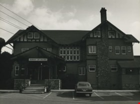
Burnaby Art Gallery
https://search.heritageburnaby.ca/link/archivedescription36265
- Repository
- City of Burnaby Archives
- Date
- 1976
- Collection/Fonds
- Burnaby Historical Society fonds
- Description Level
- Item
- Physical Description
- 1 photograph : b&w ; 18 x 24 cm, mounted on board 26 x 32.5 cm
- Scope and Content
- Photograph of the front of the Burnaby Art Gallery. There is a Datsun in the parking lot.
- Repository
- City of Burnaby Archives
- Date
- 1976
- Collection/Fonds
- Burnaby Historical Society fonds
- Subseries
- Burnaby Art Gallery subseries
- Physical Description
- 1 photograph : b&w ; 18 x 24 cm, mounted on board 26 x 32.5 cm
- Description Level
- Item
- Record No.
- 242-015
- Access Restriction
- No restrictions
- Reproduction Restriction
- Reproduce for fair dealing purposes only
- Accession Number
- BHS1990-05
- Scope and Content
- Photograph of the front of the Burnaby Art Gallery. There is a Datsun in the parking lot.
- Subjects
- Buildings - Civic - Art Galleries
- Names
- Burnaby Art Gallery
- Media Type
- Photograph
- Photographer
- Salmon, Stu
- Notes
- Photographer's note on the border of its mount reads: "S.Salmon/76"
- Geographic Access
- Deer Lake Avenue
- Street Address
- 6344 Deer Lake Avenue
- Historic Neighbourhood
- Burnaby Lake (Historic Neighbourhood)
- Planning Study Area
- Douglas-Gilpin Area
Images
