More like 'Stoney Creek Bridge'
Narrow Results By
Subject
- Buildings - Civic - City Halls 1
- Buildings - Commercial - Stores 1
- Buildings - Heritage 1
- Buildings - Industrial - Factories 2
- Buildings - Recreational 1
- Celebrations - Centennials 1
- Construction 1
- Construction Tools and Equipment 1
- Geographic Features - Beaches 2
- Geographic - Features - Creeks 1
- Geographic Features - Gardens 1
- Geographic Features - Inlets 1

Barnet Beach
https://search.heritageburnaby.ca/link/archivedescription93650
- Repository
- City of Burnaby Archives
- Date
- November 20, 1977
- Collection/Fonds
- Burnaby Public Library Contemporary Visual Archive Project
- Description Level
- Item
- Physical Description
- 1 photograph : b&w ; 12.5 x 17.5 cm
- Scope and Content
- Photograph of Burrard Inlet, taken facing west from Barnet Beach. Capitol Hill and the Second Narrows Bridge are visible in the distance.
- Repository
- City of Burnaby Archives
- Date
- November 20, 1977
- Collection/Fonds
- Burnaby Public Library Contemporary Visual Archive Project
- Physical Description
- 1 photograph : b&w ; 12.5 x 17.5 cm
- Description Level
- Item
- Record No.
- 556-607
- Access Restriction
- No restrictions
- Reproduction Restriction
- Reproduce for fair dealing purposes only
- Accession Number
- 2017-57
- Scope and Content
- Photograph of Burrard Inlet, taken facing west from Barnet Beach. Capitol Hill and the Second Narrows Bridge are visible in the distance.
- Media Type
- Photograph
- Photographer
- Chapman, Fred
- Notes
- Title taken from project information form
- Accompanied by a project information form and 1 photograph (b&w negative ; 9.5 x 12.5 cm)
- BPL no. 57
- Geographic Access
- Barnet Marine Park
- Historic Neighbourhood
- Barnet (Historic Neighbourhood)
- Planning Study Area
- Burnaby Mountain Area
Images


Barnet Marine Park
https://search.heritageburnaby.ca/link/archivedescription91581
- Repository
- City of Burnaby Archives
- Date
- August 9, 1996
- Collection/Fonds
- Doreen Lawson fonds
- Description Level
- File
- Physical Description
- 18 photographs : col. slides ; 35 mm
- Scope and Content
- File consists of photographs of Barnet Marine Park, including Barnet Beach pilings, overpass and people preparing kayaks on the shore.
- Repository
- City of Burnaby Archives
- Date
- August 9, 1996
- Collection/Fonds
- Doreen Lawson fonds
- Physical Description
- 18 photographs : col. slides ; 35 mm
- Description Level
- File
- Record No.
- 605-014
- Access Restriction
- No restrictions
- Reproduction Restriction
- No restrictions
- Accession Number
- 2003-30
- Scope and Content
- File consists of photographs of Barnet Marine Park, including Barnet Beach pilings, overpass and people preparing kayaks on the shore.
- Names
- Lawson, Doreen A.
- Media Type
- Photograph
- Photographer
- Lawson, Doreen A.
- Notes
- Title based on contents of photographs
- Note in black in on recto of slide frames of photographs 605-014-1 : 605-014-7, 605-014-9 : 605-014-11, and 605-014-13 reads: "Barnet Beach Pilings"
- Note in black ink on recto of slide frames of photographs 605-014-8 and 605-014-12 reads: "Barnet Beach Kayaks"
- Note in black ink on recto of slide frames of photographs 605-014-14 : 605-014-18 reads: "Barnet Beach Overpass"
- Geographic Access
- Barnet Marine Park
- Historic Neighbourhood
- Barnet (Historic Neighbourhood)
- Planning Study Area
- Burnaby Mountain Area
Images

![Bridge over South Creek on Burnaby Mountain, [1995] thumbnail](/media/Hpo/_Data/_Archives_Images/_Unrestricted/629/629-009.jpg?width=280)
Bridge over South Creek on Burnaby Mountain
https://search.heritageburnaby.ca/link/archivedescription97808
- Repository
- City of Burnaby Archives
- Date
- [1995]
- Collection/Fonds
- Burnaby Mountain Preservation Society fonds
- Description Level
- Item
- Physical Description
- 1 photograph : col. slide ; 35 mm
- Scope and Content
- Photograph of a creek bridge.
- Repository
- City of Burnaby Archives
- Date
- [1995]
- Collection/Fonds
- Burnaby Mountain Preservation Society fonds
- Physical Description
- 1 photograph : col. slide ; 35 mm
- Description Level
- Item
- Record No.
- 629-009
- Access Restriction
- No restrictions
- Reproduction Restriction
- Reproduce for fair dealing purposes only
- Accession Number
- 2006-13
- Scope and Content
- Photograph of a creek bridge.
- Media Type
- Photograph
- Notes
- Handwritten note on slide reads: "Bridge Over S. Creek."
- Geographic Access
- Burnaby Mountain Conservation Area
- Planning Study Area
- Burnaby Mountain Area
Images
![Bridge over South Creek on Burnaby Mountain, [1995] thumbnail](/media/Hpo/_Data/_Archives_Images/_Unrestricted/629/629-009.jpg)

Interview with Judy Hagen by Eric Damer November 7, 2012 - Track 6
https://search.heritageburnaby.ca/link/oralhistory337
- Repository
- City of Burnaby Archives
- Date Range
- 1944-2012
- Length
- 0:12:18
- Summary
- This portion of the recording pertains to Judith "Judy" (Robins) Hagen's memories of taking dance lessons and being in Girl Guides. She tells a story of seeing the Second Narrows Bridge collapse in 1958.
- Repository
- City of Burnaby Archives
- Summary
- This portion of the recording pertains to Judith "Judy" (Robins) Hagen's memories of taking dance lessons and being in Girl Guides. She tells a story of seeing the Second Narrows Bridge collapse in 1958.
- Date Range
- 1944-2012
- Photo Info
- Judith "Judy" Robins (later Hagen) posing in a dance costume, 1949. Item no. 549-036.
- Length
- 0:12:18
- Interviewer
- Damer, Eric
- Interview Date
- November 7, 2012
- Scope and Content
- Recording is an interview with Judith "Judy" (Robins) Hagen conducted by Burnaby Village Museum employee Eric Damer, November 7, 2012. Major theme discussed: the neighbourhood of Dover Street.
- Biographical Notes
- Judy Robins (later Hagen) was born in 1941 and grew up in South Burnaby. Her paternal grandfather, a master stone mason from Devon, moved to Vancouver in 1912 to find work before bringing over the rest of the family. He bought three lots in Burnaby and in 1918 moved his family to a small house on Dover Street (formerly Paul Street). Judy’s father, Jack, married, bought one of his father’s lots and built a new home for his family. Judy attended school and church nearby, took dance and piano lessons and participated actively in Girl Guides. After high school, she attended the University of British Columbia (UBC) and then Simon Fraser University (SFU), worked for a few years and then married in 1967 before moving to Courtaney, British Columbia.
- Total Tracks
- 7
- Total Length
- 1:09:51
- Interviewee Name
- Hagen, Judith "Judy" Robins
- Interview Location
- Nanaimo Museum on Vancouver Island
- Interviewer Bio
- Eric Damer is a lifelong British Columbian born in Victoria, raised in Kamloops, and currently residing in Burnaby. After studying philosophy at the University of Victoria, he became interested in the educational forces that had shaped his own life. He completed master’s and doctoral degrees in educational studies at the University of British Columbia with a particular interest in the history of adult and higher education in the province. In 2012, Eric worked for the City of Burnaby as a field researcher and writer, conducting interviews for the City Archives and Museum Oral History Program.
- Collection/Fonds
- Community Heritage Commission Special Projects fonds
- Transcript Available
- None
- Media Type
- Sound Recording
Images

Audio Tracks
Track six of recording of interview with Judy Hagen
Track six of recording of interview with Judy Hagen
https://search.heritageburnaby.ca/media/hpo/_Data/_Archives_Oral_Histories/_Unrestricted/MSS171-011/MSS171-011_Track_6.mp3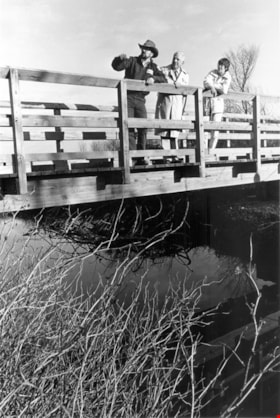
Liz Thurstrom, Bob Gardner, and Ken Elliot
https://search.heritageburnaby.ca/link/archivedescription78731
- Repository
- City of Burnaby Archives
- Date
- December 10, 1995
- Collection/Fonds
- Burnaby NewsLeader photograph collection
- Description Level
- Item
- Physical Description
- 1 photograph : b&w ; 23.5 x 16 cm
- Scope and Content
- Photograph of Liz Thurstrom, of the Wildlife Rescue Association of British Columbia, Bob Gardner, of the Burnaby Lake advisory council and Ken Elliot, of the Greater Vancouver Regional District (GVRD) atop the new footbridge completing the Burnaby Lake Trail.
- Repository
- City of Burnaby Archives
- Date
- December 10, 1995
- Collection/Fonds
- Burnaby NewsLeader photograph collection
- Physical Description
- 1 photograph : b&w ; 23.5 x 16 cm
- Description Level
- Item
- Record No.
- 535-0088
- Access Restriction
- No restrictions
- Reproduction Restriction
- No reproduction permitted
- Accession Number
- 2012-11
- Scope and Content
- Photograph of Liz Thurstrom, of the Wildlife Rescue Association of British Columbia, Bob Gardner, of the Burnaby Lake advisory council and Ken Elliot, of the Greater Vancouver Regional District (GVRD) atop the new footbridge completing the Burnaby Lake Trail.
- Media Type
- Photograph
- Photographer
- Bartel, Mario
- Notes
- Title based on contents of photograph
- Note in black and blue ink on recto of photograph reads: "3454 A Bby Mario / 95% Bby p.1"
- Trim marks and/or reproduction instructions on recto (scan is cropped)
- Geographic Access
- Burnaby Lake
Images


Municipal Hall & Overpass
https://search.heritageburnaby.ca/link/archivedescription93610
- Repository
- City of Burnaby Archives
- Date
- October 17, 1977
- Collection/Fonds
- Burnaby Public Library Contemporary Visual Archive Project
- Description Level
- Item
- Physical Description
- 1 photograph : b&w ; 12.5 x 17.5 cm
- Scope and Content
- Photograph of the pedestrian overpass by the Burnaby Municipal Hall on the 4900 block of Canada Way and part of one of the buildings of the Municipal Hall complex. The photograph is taken from the north sidewalk on Canada Way, facing west.
- Repository
- City of Burnaby Archives
- Date
- October 17, 1977
- Collection/Fonds
- Burnaby Public Library Contemporary Visual Archive Project
- Physical Description
- 1 photograph : b&w ; 12.5 x 17.5 cm
- Description Level
- Item
- Record No.
- 556-567
- Access Restriction
- No restrictions
- Reproduction Restriction
- Reproduce for fair dealing purposes only
- Accession Number
- 2017-57
- Scope and Content
- Photograph of the pedestrian overpass by the Burnaby Municipal Hall on the 4900 block of Canada Way and part of one of the buildings of the Municipal Hall complex. The photograph is taken from the north sidewalk on Canada Way, facing west.
- Media Type
- Photograph
- Photographer
- Olsen, John
- Notes
- Title taken from project information form
- Accompanied by a project information form and 1 photograph (b&w negative ; 9.5 x 12.5 cm)
- BPL no. 13
- Geographic Access
- Canada Way
- Street Address
- 4949 Canada Way
- Historic Neighbourhood
- Burnaby Lake (Historic Neighbourhood)
- Planning Study Area
- Douglas-Gilpin Area
Images

![Stoney Creek Bridge, [1998-1999] thumbnail](/media/Hpo/_Data/_Archives_Images/_Unrestricted/316/353-007.jpg?width=280)
Stoney Creek Bridge
https://search.heritageburnaby.ca/link/archivedescription66639
- Repository
- City of Burnaby Archives
- Date
- [1998-1999]
- Collection/Fonds
- Millway family fonds
- Description Level
- Item
- Physical Description
- 1 photograph : col. ; 10 x 30.5 cm
- Scope and Content
- Photograph of Stoney Creek Bridge taken from a distance. A bicycle rider is about to cross the bridge.
- Repository
- City of Burnaby Archives
- Date
- [1998-1999]
- Collection/Fonds
- Millway family fonds
- Physical Description
- 1 photograph : col. ; 10 x 30.5 cm
- Description Level
- Item
- Record No.
- 353-007
- Access Restriction
- No restrictions
- Reproduction Restriction
- Reproduce for fair dealing purposes only
- Accession Number
- 2011-05
- Scope and Content
- Photograph of Stoney Creek Bridge taken from a distance. A bicycle rider is about to cross the bridge.
- Subjects
- Structures - Bridges
- Media Type
- Photograph
- Notes
- Title based on contents of photograph
- Historic Neighbourhood
- Burquitlam (Historic Neighbourhood)
- Planning Study Area
- Lyndhurst Area
Images
![Stoney Creek Bridge, [1998-1999] thumbnail](/media/Hpo/_Data/_Archives_Images/_Unrestricted/316/353-007.jpg)

Stream in Robert Burnaby Park
https://search.heritageburnaby.ca/link/archivedescription93668
- Repository
- City of Burnaby Archives
- Date
- January 15, 1978
- Collection/Fonds
- Burnaby Public Library Contemporary Visual Archive Project
- Description Level
- Item
- Physical Description
- 1 photograph : b&w ; 12.5 x 17.5 cm
- Scope and Content
- Photograph of a mostly dry stream in Robert Burnaby Park. The stream is surrounded by a forested area and the photograph shows a footbridge in the background. The photograph is taken in front of the stream, facing south.
- Repository
- City of Burnaby Archives
- Date
- January 15, 1978
- Collection/Fonds
- Burnaby Public Library Contemporary Visual Archive Project
- Physical Description
- 1 photograph : b&w ; 12.5 x 17.5 cm
- Description Level
- Item
- Record No.
- 556-625
- Access Restriction
- No restrictions
- Reproduction Restriction
- Reproduce for fair dealing purposes only
- Accession Number
- 2017-57
- Scope and Content
- Photograph of a mostly dry stream in Robert Burnaby Park. The stream is surrounded by a forested area and the photograph shows a footbridge in the background. The photograph is taken in front of the stream, facing south.
- Media Type
- Photograph
- Photographer
- Surridge, Jack
- Notes
- Title taken from project information form
- Accompanied by a project information form and 1 photograph (b&w negative ; 9.5 x 12.5 cm)
- BPL no. 74
- Geographic Access
- Robert Burnaby Park
- Historic Neighbourhood
- Burnaby Lake (Historic Neighbourhood)
- Planning Study Area
- Lakeview-Mayfield Area
Images

![Walking bridge on Burnaby Mountain, [1995] thumbnail](/media/Hpo/_Data/_Archives_Images/_Unrestricted/629/629-007.jpg?width=280)
Walking bridge on Burnaby Mountain
https://search.heritageburnaby.ca/link/archivedescription97806
- Repository
- City of Burnaby Archives
- Date
- [1995]
- Collection/Fonds
- Burnaby Mountain Preservation Society fonds
- Description Level
- Item
- Physical Description
- 1 photograph : col. slide ; 35 mm
- Scope and Content
- Photograph of a walking bridge.
- Repository
- City of Burnaby Archives
- Date
- [1995]
- Collection/Fonds
- Burnaby Mountain Preservation Society fonds
- Physical Description
- 1 photograph : col. slide ; 35 mm
- Description Level
- Item
- Record No.
- 629-007
- Access Restriction
- No restrictions
- Reproduction Restriction
- Reproduce for fair dealing purposes only
- Accession Number
- 2006-13
- Scope and Content
- Photograph of a walking bridge.
- Subjects
- Structures - Bridges
- Media Type
- Photograph
- Notes
- Handwritten note on slide reads: "Mel T. Bridge."
- Geographic Access
- Burnaby Mountain Conservation Area
- Planning Study Area
- Burnaby Mountain Area
Images
![Walking bridge on Burnaby Mountain, [1995] thumbnail](/media/Hpo/_Data/_Archives_Images/_Unrestricted/629/629-007.jpg)
![Painting the wall, [1999] thumbnail](/media/hpo/_Data/_Archives_Images/_Unrestricted/535/535-3157.jpg?width=280)
Painting the wall
https://search.heritageburnaby.ca/link/archivedescription98077
- Repository
- City of Burnaby Archives
- Date
- [1999]
- Collection/Fonds
- Burnaby NewsLeader photograph collection
- Description Level
- Item
- Physical Description
- 1 photograph (tiff) : col.
- Scope and Content
- Photograph of an unidentified person painting the wall beneath a brick arch.
- Repository
- City of Burnaby Archives
- Date
- [1999]
- Collection/Fonds
- Burnaby NewsLeader photograph collection
- Physical Description
- 1 photograph (tiff) : col.
- Description Level
- Item
- Record No.
- 535-3157
- Access Restriction
- No restrictions
- Reproduction Restriction
- No restrictions
- Accession Number
- 2018-12
- Scope and Content
- Photograph of an unidentified person painting the wall beneath a brick arch.
- Subjects
- Structures
- Structures - Arches
- Media Type
- Photograph
- Notes
- Title based on original file name
- Collected by editorial for use in an April 1999 issue of the Burnaby NewsLeader
Images
![Painting the wall, [1999] thumbnail](/media/hpo/_Data/_Archives_Images/_Unrestricted/535/535-3157.jpg)

Continental Can Company
https://search.heritageburnaby.ca/link/archivedescription93708
- Repository
- City of Burnaby Archives
- Date
- February 24, 1978
- Collection/Fonds
- Burnaby Public Library Contemporary Visual Archive Project
- Description Level
- Item
- Physical Description
- 1 photograph : b&w ; 12.5 x 17.5 cm
- Scope and Content
- Photograph of the exterior of Continental Can Company factory, located on Winston Street by Burnaby Lake. The photograph is taken from across Winston Street, facing south, and the railway tracks are visible in front of the manufacturing plant. The Continental Can water tower stands in the backgroun…
- Repository
- City of Burnaby Archives
- Date
- February 24, 1978
- Collection/Fonds
- Burnaby Public Library Contemporary Visual Archive Project
- Physical Description
- 1 photograph : b&w ; 12.5 x 17.5 cm
- Description Level
- Item
- Record No.
- 556-665
- Access Restriction
- No restrictions
- Reproduction Restriction
- Reproduce for fair dealing purposes only
- Accession Number
- 2017-57
- Scope and Content
- Photograph of the exterior of Continental Can Company factory, located on Winston Street by Burnaby Lake. The photograph is taken from across Winston Street, facing south, and the railway tracks are visible in front of the manufacturing plant. The Continental Can water tower stands in the background, and there are signs on the side of the road for a "spindle sale" and Braemar Gardens.
- Names
- Continental Can Co.
- Media Type
- Photograph
- Photographer
- Surridge, Jack
- Notes
- Title taken from project information form
- Accompanied by a project information form and 1 photograph (b&w negative ; 9.5 x 12.5 cm)
- BPL no. 113
- Geographic Access
- Winston Street
- Burnaby Lake
- Historic Neighbourhood
- Lozells (Historic Neighbourhood)
- Planning Study Area
- Government Road Area
Images

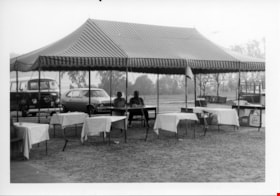
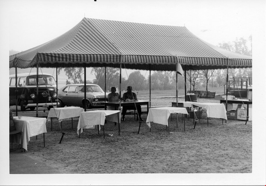
Event tent
https://search.heritageburnaby.ca/link/museumdescription2280
- Repository
- Burnaby Village Museum
- Date
- 1971
- Collection/Fonds
- Donald Copan collection
- Description Level
- Item
- Physical Description
- 1 photograph : b&w ; 8.9 x 12.7 cm
- Scope and Content
- Photograph of tent and tables set up for a 1971 Centennial event. There are two people sitting under tent.
- Repository
- Burnaby Village Museum
- Collection/Fonds
- Donald Copan collection
- Series
- Copan album series
- Description Level
- Item
- Physical Description
- 1 photograph : b&w ; 8.9 x 12.7 cm
- Scope and Content
- Photograph of tent and tables set up for a 1971 Centennial event. There are two people sitting under tent.
- Accession Code
- BV005.54.326
- Access Restriction
- No restrictions
- Reproduction Restriction
- May be restricted by third party rights
- Date
- 1971
- Media Type
- Photograph
- Scan Resolution
- 600
- Scan Date
- July 23, 2020
- Scale
- 100
- Notes
- Title based on contents of photograph
Images
![Local construction, [1999] thumbnail](/media/hpo/_Data/_Archives_Images/_Unrestricted/535/535-3205-1.jpg?width=280)
Local construction
https://search.heritageburnaby.ca/link/archivedescription98126
- Repository
- City of Burnaby Archives
- Date
- [1999]
- Collection/Fonds
- Burnaby NewsLeader photograph collection
- Description Level
- File
- Physical Description
- 2 photographs (tiff) : col.
- Scope and Content
- File contains photographs of two unidentified people observing evidence of construction. One photograph depicts a person looking at a crack in a floor tile while holding a land survey map, and the other depicts an individual looking at a piece of construction equipment on the other side of a chain …
- Repository
- City of Burnaby Archives
- Date
- [1999]
- Collection/Fonds
- Burnaby NewsLeader photograph collection
- Physical Description
- 2 photographs (tiff) : col.
- Description Level
- File
- Record No.
- 535-3205
- Access Restriction
- No restrictions
- Reproduction Restriction
- No restrictions
- Accession Number
- 2018-12
- Scope and Content
- File contains photographs of two unidentified people observing evidence of construction. One photograph depicts a person looking at a crack in a floor tile while holding a land survey map, and the other depicts an individual looking at a piece of construction equipment on the other side of a chain link fence.
- Media Type
- Photograph
- Notes
- Title based on contents of file
- Collected by editorial for use in a June 1999 issue of the Burnaby NewsLeader
Images
![Local construction, [1999] thumbnail](/media/hpo/_Data/_Archives_Images/_Unrestricted/535/535-3205-1.jpg)

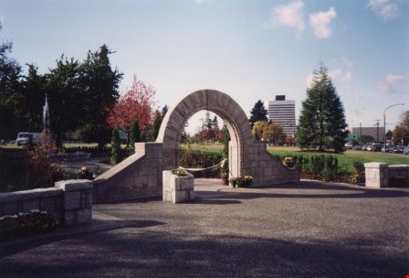
Opening of Lohn Gardens and Restored Jubilee Grove Arch
https://search.heritageburnaby.ca/link/archivedescription37358
- Repository
- City of Burnaby Archives
- Date
- 1994
- Collection/Fonds
- Burnaby Historical Society fonds
- Description Level
- Item
- Physical Description
- 1 photograph : col. ; 10 x 15 cm
- Scope and Content
- Photograph of the Earl and Jennie Lohn Perennial Garden and the restored Jubilee Grove Arch - taken during the opening of the gardens in 1994 after the restoration work was completed. This Central Park landmark was built in 1939 as part of "Jubilee Grove", a garden established in 1935 to commemora…
- Repository
- City of Burnaby Archives
- Date
- 1994
- Collection/Fonds
- Burnaby Historical Society fonds
- Subseries
- Photographs subseries
- Physical Description
- 1 photograph : col. ; 10 x 15 cm
- Description Level
- Item
- Record No.
- 360-001
- Access Restriction
- No restrictions
- Reproduction Restriction
- Reproduce for fair dealing purposes only
- Accession Number
- BHS2007-04
- Scope and Content
- Photograph of the Earl and Jennie Lohn Perennial Garden and the restored Jubilee Grove Arch - taken during the opening of the gardens in 1994 after the restoration work was completed. This Central Park landmark was built in 1939 as part of "Jubilee Grove", a garden established in 1935 to commemorate the Jubilee of King George V and dedicated during Burnaby's May Day Celebration.
- Media Type
- Photograph
- Notes
- Title based on contents of photograph
- Geographic Access
- Kingsway
- Patterson Avenue
- Historic Neighbourhood
- Central Park (Historic Neighbourhood)
- Planning Study Area
- Garden Village Area
Images

Original gateposts of Sprott Lodge
https://search.heritageburnaby.ca/link/archivedescription38374
- Repository
- City of Burnaby Archives
- Date
- 1990
- Collection/Fonds
- Burnaby Historical Society fonds
- Description Level
- Item
- Physical Description
- 1 photograph : col. ; 8.8 x 13 cm
- Scope and Content
- Photograph of the original gateposts and the driveway leading into the site of Mayfield Lodge, which was owned by L.E.Sprott.
- Repository
- City of Burnaby Archives
- Date
- 1990
- Collection/Fonds
- Burnaby Historical Society fonds
- Subseries
- Municipal record subseries
- Physical Description
- 1 photograph : col. ; 8.8 x 13 cm
- Description Level
- Item
- Record No.
- 422-005
- Access Restriction
- No restrictions
- Reproduction Restriction
- Reproduce for fair dealing purposes only
- Accession Number
- BHS2001-09
- Scope and Content
- Photograph of the original gateposts and the driveway leading into the site of Mayfield Lodge, which was owned by L.E.Sprott.
- Subjects
- Buildings - Heritage
- Structures - Fences
- Media Type
- Photograph
- Photographer
- Wolf, Jim
- Notes
- Title based on contents of photograph.
- Geographic Access
- Canada Way
- Historic Neighbourhood
- Burnaby Lake (Historic Neighbourhood)
- Planning Study Area
- Morley-Buckingham Area
Images

![Person with treehouse, [1999] thumbnail](/media/hpo/_Data/_Archives_Images/_Unrestricted/535/535-3172.jpg?width=280)
Person with treehouse
https://search.heritageburnaby.ca/link/archivedescription98092
- Repository
- City of Burnaby Archives
- Date
- [1999]
- Collection/Fonds
- Burnaby NewsLeader photograph collection
- Description Level
- Item
- Physical Description
- 1 photograph (tiff) : col.
- Scope and Content
- Photograph of an unidentified person posing with a treehouse.
- Repository
- City of Burnaby Archives
- Date
- [1999]
- Collection/Fonds
- Burnaby NewsLeader photograph collection
- Physical Description
- 1 photograph (tiff) : col.
- Description Level
- Item
- Record No.
- 535-3172
- Access Restriction
- No restrictions
- Reproduction Restriction
- No restrictions
- Accession Number
- 2018-12
- Scope and Content
- Photograph of an unidentified person posing with a treehouse.
- Subjects
- Structures
- Buildings - Recreational
- Media Type
- Photograph
- Notes
- Title based on caption
- Collected by editorial for use in a May 1999 issue of the Burnaby NewsLeader
Images
![Person with treehouse, [1999] thumbnail](/media/hpo/_Data/_Archives_Images/_Unrestricted/535/535-3172.jpg)

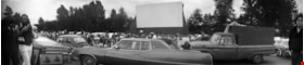
Swap meet
https://search.heritageburnaby.ca/link/archivedescription51785
- Repository
- City of Burnaby Archives
- Date
- 1974
- Collection/Fonds
- Harold H. Johnston fonds
- Description Level
- Item
- Physical Description
- 1 photograph (jpeg) : b&w, panorama
- Scope and Content
- Photograph of people and automobiles gathered at the site of a drive-in theatre for a swap meet. Numerous vendors can be seen with their merchandise displayed on tables. The location of this photograph may be the Lougheed Drive-in Theatre as swap meets were held there often throughout the 1970s a…
- Repository
- City of Burnaby Archives
- Date
- 1974
- Collection/Fonds
- Harold H. Johnston fonds
- Physical Description
- 1 photograph (jpeg) : b&w, panorama
- Description Level
- Item
- Record No.
- 483-087
- Access Restriction
- No restrictions
- Reproduction Restriction
- No reproduction permitted
- Accession Number
- 2008-08
- Scope and Content
- Photograph of people and automobiles gathered at the site of a drive-in theatre for a swap meet. Numerous vendors can be seen with their merchandise displayed on tables. The location of this photograph may be the Lougheed Drive-in Theatre as swap meets were held there often throughout the 1970s and 1980s.
- Media Type
- Photograph
- Photographer
- Johnston, Harold H.
- Notes
- Title based on contents of photograph
- Geographic Access
- Lougheed Highway
- Historic Neighbourhood
- Broadview (Historic Neighbourhood)
- Planning Study Area
- West Central Valley Area
Images

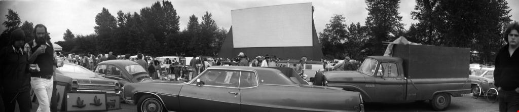
Swap meet
https://search.heritageburnaby.ca/link/archivedescription52342
- Repository
- City of Burnaby Archives
- Date
- 1974
- Collection/Fonds
- Harold H. Johnston fonds
- Description Level
- Item
- Physical Description
- 1 photograph (jpeg) : b&w, panorama
- Scope and Content
- Photograph of people and automobiles gathered at the site of a drive-in theatre for a swap meet. The location of this photograph may be the Lougheed Drive-in Theatre as swap meets were held there throughout the 1970s and 1980s.
- Repository
- City of Burnaby Archives
- Date
- 1974
- Collection/Fonds
- Harold H. Johnston fonds
- Physical Description
- 1 photograph (jpeg) : b&w, panorama
- Description Level
- Item
- Record No.
- 483-089
- Access Restriction
- No restrictions
- Reproduction Restriction
- No reproduction permitted
- Accession Number
- 2008-08
- Scope and Content
- Photograph of people and automobiles gathered at the site of a drive-in theatre for a swap meet. The location of this photograph may be the Lougheed Drive-in Theatre as swap meets were held there throughout the 1970s and 1980s.
- Media Type
- Photograph
- Photographer
- Johnston, Harold H.
- Notes
- Title based on contents of photograph
- Geographic Access
- Lougheed Highway
- Historic Neighbourhood
- Broadview (Historic Neighbourhood)
- Planning Study Area
- West Central Valley Area
Images

Warehouses - Burnaby Lake
https://search.heritageburnaby.ca/link/archivedescription93627
- Repository
- City of Burnaby Archives
- Date
- October 22, 1977
- Collection/Fonds
- Burnaby Public Library Contemporary Visual Archive Project
- Description Level
- Item
- Physical Description
- 1 photograph : b&w ; 12.5 x 17.5 cm
- Scope and Content
- Photograph of commercial and industrial buildings by Burnaby Lake on Winston Street. The photograph is taken from a high point, facing south. The photograph shows the Furniture Fair warehouse and parking lot in the foreground and the Continental Can Company plant and its water tower are in the back…
- Repository
- City of Burnaby Archives
- Date
- October 22, 1977
- Collection/Fonds
- Burnaby Public Library Contemporary Visual Archive Project
- Physical Description
- 1 photograph : b&w ; 12.5 x 17.5 cm
- Description Level
- Item
- Record No.
- 556-584
- Access Restriction
- No restrictions
- Reproduction Restriction
- Reproduce for fair dealing purposes only
- Accession Number
- 2017-57
- Scope and Content
- Photograph of commercial and industrial buildings by Burnaby Lake on Winston Street. The photograph is taken from a high point, facing south. The photograph shows the Furniture Fair warehouse and parking lot in the foreground and the Continental Can Company plant and its water tower are in the background.
- Subjects
- Buildings - Commercial - Stores
- Buildings - Industrial - Factories
- Structures - Water Tanks and Towers
- Names
- Continental Can Co.
- Media Type
- Photograph
- Photographer
- Surridge, Jack
- Notes
- Title taken from project information form
- Accompanied by a project information form and 1 photograph (b&w negative ; 9.5 x 12.5 cm)
- BPL no. 33
- Geographic Access
- Winston Street
- Burnaby Lake
- Historic Neighbourhood
- Lozells (Historic Neighbourhood)
- Planning Study Area
- Government Road Area
Images
