More like 'Opening of Lohn Gardens and Restored Jubilee Grove Arch'
Narrow Results By

Jubilee Arch
https://search.heritageburnaby.ca/link/archivedescription34858
- Repository
- City of Burnaby Archives
- Date
- March 7, 1985
- Collection/Fonds
- Burnaby Historical Society fonds
- Description Level
- Item
- Physical Description
- 1 photograph : col. ; 8.8 x 11.4 cm
- Scope and Content
- Photograph of the back of the Central Park Arch at Patterson Avenue and Kingsway.
- Repository
- City of Burnaby Archives
- Date
- March 7, 1985
- Collection/Fonds
- Burnaby Historical Society fonds
- Subseries
- Evelyn Salisbury subseries
- Physical Description
- 1 photograph : col. ; 8.8 x 11.4 cm
- Description Level
- Item
- Record No.
- 145-006
- Access Restriction
- No restrictions
- Reproduction Restriction
- Reproduce for fair dealing purposes only
- Accession Number
- BHS1985-15
- Scope and Content
- Photograph of the back of the Central Park Arch at Patterson Avenue and Kingsway.
- Media Type
- Photograph
- Notes
- Title based on contents of photograph
- Geographic Access
- Central Park
- Imperial Street
- Street Address
- 3883 Imperial Street
- Historic Neighbourhood
- Central Park (Historic Neighbourhood)
- Planning Study Area
- Maywood Area
Images


Jubilee Arch
https://search.heritageburnaby.ca/link/archivedescription34859
- Repository
- City of Burnaby Archives
- Date
- March 7, 1985
- Collection/Fonds
- Burnaby Historical Society fonds
- Description Level
- Item
- Physical Description
- 1 photograph : col. ; 8.8 x 11.3 cm
- Scope and Content
- Photograph of the front of the Central Park Arch at Patterson Avenue and Kingsway.
- Repository
- City of Burnaby Archives
- Date
- March 7, 1985
- Collection/Fonds
- Burnaby Historical Society fonds
- Subseries
- Evelyn Salisbury subseries
- Physical Description
- 1 photograph : col. ; 8.8 x 11.3 cm
- Description Level
- Item
- Record No.
- 145-007
- Access Restriction
- No restrictions
- Reproduction Restriction
- Reproduce for fair dealing purposes only
- Accession Number
- BHS1985-15
- Scope and Content
- Photograph of the front of the Central Park Arch at Patterson Avenue and Kingsway.
- Media Type
- Photograph
- Notes
- Title based on contents of photograph
- Geographic Access
- Central Park
- Imperial Street
- Street Address
- 3883 Imperial Street
- Historic Neighbourhood
- Central Park (Historic Neighbourhood)
- Planning Study Area
- Maywood Area
Images

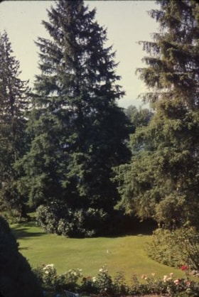
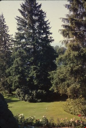
6088 Cassie Avenue
https://search.heritageburnaby.ca/link/archivedescription93717
- Repository
- City of Burnaby Archives
- Date
- 1987
- Collection/Fonds
- Grover, Elliott & Co. Ltd. fonds
- Description Level
- File
- Physical Description
- 14 photographs : col. negatives ; 35 mm + 5 photographs : col. ; 10 cm x 15 cm
- Scope and Content
- Photographs of the private residence and garden located at 6088 Cassie Avenue - an address that no longer exists.
- Repository
- City of Burnaby Archives
- Date
- 1987
- Collection/Fonds
- Grover, Elliott & Co. Ltd. fonds
- Physical Description
- 14 photographs : col. negatives ; 35 mm + 5 photographs : col. ; 10 cm x 15 cm
- Description Level
- File
- Record No.
- 622-006
- Access Restriction
- No restrictions
- Reproduction Restriction
- No restrictions
- Accession Number
- 2017-39
- Scope and Content
- Photographs of the private residence and garden located at 6088 Cassie Avenue - an address that no longer exists.
- Media Type
- Photograph
- Notes
- Transcribed title
- Title transcribed from original print envelope
- File no. 87-300-B
- Geographic Access
- Cassie Avenue
- Historic Neighbourhood
- Central Park (Historic Neighbourhood)
- Planning Study Area
- Maywood Area

Central Park Entrance
https://search.heritageburnaby.ca/link/archivedescription34860
- Repository
- City of Burnaby Archives
- Date
- March 23, 1985
- Collection/Fonds
- Burnaby Historical Society fonds
- Description Level
- Item
- Physical Description
- 1 photograph : col. ; 8.8 x 11.3 cm
- Scope and Content
- Photograph of the Central Park entrance on Kingsway. A car can be seen exiting the park, and the tracks of the Skytrain Expo line are in the background.
- Repository
- City of Burnaby Archives
- Date
- March 23, 1985
- Collection/Fonds
- Burnaby Historical Society fonds
- Subseries
- Evelyn Salisbury subseries
- Physical Description
- 1 photograph : col. ; 8.8 x 11.3 cm
- Description Level
- Item
- Record No.
- 145-008
- Access Restriction
- No restrictions
- Reproduction Restriction
- Reproduce for fair dealing purposes only
- Accession Number
- BHS1985-15
- Scope and Content
- Photograph of the Central Park entrance on Kingsway. A car can be seen exiting the park, and the tracks of the Skytrain Expo line are in the background.
- Subjects
- Structures - Arches
- Media Type
- Photograph
- Notes
- Title based on contents of photograph
- Geographic Access
- Central Park
- Imperial Street
- Street Address
- 3883 Imperial Street
- Historic Neighbourhood
- Central Park (Historic Neighbourhood)
- Planning Study Area
- Maywood Area
Images


Central Park Entrance
https://search.heritageburnaby.ca/link/archivedescription34861
- Repository
- City of Burnaby Archives
- Date
- March 23, 1985
- Collection/Fonds
- Burnaby Historical Society fonds
- Description Level
- Item
- Physical Description
- 1 photograph : col. ; 8.8 x 11.3 cm
- Scope and Content
- Photograph of the Central Park entrance on Kingsway. The tracks of the Skytrain Expo line can be seen in the background.
- Repository
- City of Burnaby Archives
- Date
- March 23, 1985
- Collection/Fonds
- Burnaby Historical Society fonds
- Subseries
- Evelyn Salisbury subseries
- Physical Description
- 1 photograph : col. ; 8.8 x 11.3 cm
- Description Level
- Item
- Record No.
- 145-009
- Access Restriction
- No restrictions
- Reproduction Restriction
- Reproduce for fair dealing purposes only
- Accession Number
- BHS1985-15
- Scope and Content
- Photograph of the Central Park entrance on Kingsway. The tracks of the Skytrain Expo line can be seen in the background.
- Subjects
- Structures - Arches
- Media Type
- Photograph
- Notes
- Title based on contents of photograph
- Geographic Access
- Central Park
- Imperial Street
- Street Address
- 3883 Imperial Street
- Historic Neighbourhood
- Central Park (Historic Neighbourhood)
- Planning Study Area
- Maywood Area
Images


Barnet Beach
https://search.heritageburnaby.ca/link/archivedescription93650
- Repository
- City of Burnaby Archives
- Date
- November 20, 1977
- Collection/Fonds
- Burnaby Public Library Contemporary Visual Archive Project
- Description Level
- Item
- Physical Description
- 1 photograph : b&w ; 12.5 x 17.5 cm
- Scope and Content
- Photograph of Burrard Inlet, taken facing west from Barnet Beach. Capitol Hill and the Second Narrows Bridge are visible in the distance.
- Repository
- City of Burnaby Archives
- Date
- November 20, 1977
- Collection/Fonds
- Burnaby Public Library Contemporary Visual Archive Project
- Physical Description
- 1 photograph : b&w ; 12.5 x 17.5 cm
- Description Level
- Item
- Record No.
- 556-607
- Access Restriction
- No restrictions
- Reproduction Restriction
- Reproduce for fair dealing purposes only
- Accession Number
- 2017-57
- Scope and Content
- Photograph of Burrard Inlet, taken facing west from Barnet Beach. Capitol Hill and the Second Narrows Bridge are visible in the distance.
- Media Type
- Photograph
- Photographer
- Chapman, Fred
- Notes
- Title taken from project information form
- Accompanied by a project information form and 1 photograph (b&w negative ; 9.5 x 12.5 cm)
- BPL no. 57
- Geographic Access
- Barnet Marine Park
- Historic Neighbourhood
- Barnet (Historic Neighbourhood)
- Planning Study Area
- Burnaby Mountain Area
Images


Stream in Robert Burnaby Park
https://search.heritageburnaby.ca/link/archivedescription93668
- Repository
- City of Burnaby Archives
- Date
- January 15, 1978
- Collection/Fonds
- Burnaby Public Library Contemporary Visual Archive Project
- Description Level
- Item
- Physical Description
- 1 photograph : b&w ; 12.5 x 17.5 cm
- Scope and Content
- Photograph of a mostly dry stream in Robert Burnaby Park. The stream is surrounded by a forested area and the photograph shows a footbridge in the background. The photograph is taken in front of the stream, facing south.
- Repository
- City of Burnaby Archives
- Date
- January 15, 1978
- Collection/Fonds
- Burnaby Public Library Contemporary Visual Archive Project
- Physical Description
- 1 photograph : b&w ; 12.5 x 17.5 cm
- Description Level
- Item
- Record No.
- 556-625
- Access Restriction
- No restrictions
- Reproduction Restriction
- Reproduce for fair dealing purposes only
- Accession Number
- 2017-57
- Scope and Content
- Photograph of a mostly dry stream in Robert Burnaby Park. The stream is surrounded by a forested area and the photograph shows a footbridge in the background. The photograph is taken in front of the stream, facing south.
- Media Type
- Photograph
- Photographer
- Surridge, Jack
- Notes
- Title taken from project information form
- Accompanied by a project information form and 1 photograph (b&w negative ; 9.5 x 12.5 cm)
- BPL no. 74
- Geographic Access
- Robert Burnaby Park
- Historic Neighbourhood
- Burnaby Lake (Historic Neighbourhood)
- Planning Study Area
- Lakeview-Mayfield Area
Images


Backyard of 4447 Venables Street
https://search.heritageburnaby.ca/link/archivedescription52358
- Repository
- City of Burnaby Archives
- Date
- 1974
- Collection/Fonds
- Harold H. Johnston fonds
- Description Level
- Item
- Physical Description
- 1 photograph (jpeg) : b&w
- Scope and Content
- Photograph looking east from the backyard of the Johnston family home at 4447 Venables Street. A clothesline draped with clothes can be seen in the background.
- Repository
- City of Burnaby Archives
- Date
- 1974
- Collection/Fonds
- Harold H. Johnston fonds
- Physical Description
- 1 photograph (jpeg) : b&w
- Description Level
- Item
- Record No.
- 483-091
- Access Restriction
- No restrictions
- Reproduction Restriction
- No reproduction permitted
- Accession Number
- 2008-08
- Scope and Content
- Photograph looking east from the backyard of the Johnston family home at 4447 Venables Street. A clothesline draped with clothes can be seen in the background.
- Media Type
- Photograph
- Photographer
- Johnston, Harold H.
- Notes
- Title based on contents of photograph
- Geographic Access
- Venables Street
- Street Address
- 4447 Venables Street
- Historic Neighbourhood
- Vancouver Heights (Historic Neighbourhood)
- Planning Study Area
- Willingdon Heights Area
Images


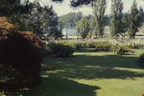
Century Gardens
https://search.heritageburnaby.ca/link/archivedescription37402
- Repository
- City of Burnaby Archives
- Date
- 1970
- Collection/Fonds
- Burnaby Historical Society fonds
- Description Level
- Item
- Physical Description
- 1 photograph : col. postcard ; 9 x 14 cm
- Scope and Content
- Photographic postcard looking over the Century Gardens, towards the Ceperley House in Deer Lake. The caption on the reverse of the postcard reads: "Century Gardens was Burnaby's Centennial Project commemorating Canada's 100th birthday. The Corporation bought this mansion and its spacious grounds …
- Repository
- City of Burnaby Archives
- Date
- 1970
- Collection/Fonds
- Burnaby Historical Society fonds
- Subseries
- Robert Prittie subseries
- Physical Description
- 1 photograph : col. postcard ; 9 x 14 cm
- Description Level
- Item
- Record No.
- 369-001
- Access Restriction
- No restrictions
- Reproduction Restriction
- Reproduce for fair dealing purposes only
- Accession Number
- BHS1999-01
- Scope and Content
- Photographic postcard looking over the Century Gardens, towards the Ceperley House in Deer Lake. The caption on the reverse of the postcard reads: "Century Gardens was Burnaby's Centennial Project commemorating Canada's 100th birthday. The Corporation bought this mansion and its spacious grounds located on the north shore of Deer Lake. The building was restored and now operates as Burnaby's new Art Centre. The grounds were relandscaped and over 2000 rhododendrons, Burnaby's official flower, were planted to promote the numerous named varieties which can be grown in the lower mainland."
- Media Type
- Photograph
- Photographer
- George Allen Aerial Photos Limited
- Notes
- Title based on caption
- Geographic Access
- Deer Lake Avenue
- Street Address
- 6344 Deer Lake Avenue
- Historic Neighbourhood
- Burnaby Lake (Historic Neighbourhood)
- Planning Study Area
- Douglas-Gilpin Area
Images

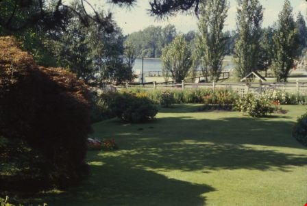
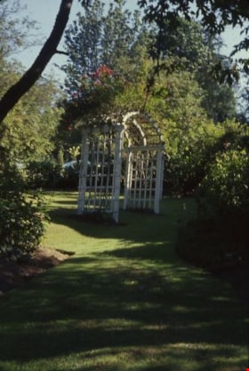
Eagles' garden
https://search.heritageburnaby.ca/link/archivedescription38321
- Repository
- City of Burnaby Archives
- Date
- 1972
- Collection/Fonds
- Burnaby Historical Society fonds
- Description Level
- Item
- Physical Description
- 1 photograph : col. slide ; 5 x 5 cm
- Scope and Content
- Slide of a portion of the Eagles' estate gardens at Deer Lake. These gardens and the home are currently protected as a heritage sites in Burnaby.
- Repository
- City of Burnaby Archives
- Date
- 1972
- Collection/Fonds
- Burnaby Historical Society fonds
- Subseries
- Eagles family subseries
- Physical Description
- 1 photograph : col. slide ; 5 x 5 cm
- Description Level
- Item
- Record No.
- 404-016
- Access Restriction
- No restrictions
- Reproduction Restriction
- Reproduce for fair dealing purposes only
- Accession Number
- BHS2000-4
- Scope and Content
- Slide of a portion of the Eagles' estate gardens at Deer Lake. These gardens and the home are currently protected as a heritage sites in Burnaby.
- Subjects
- Geographic Features - Gardens
- Media Type
- Photograph
- Notes
- Title based on contents of photograph
- Geographic Access
- Sperling Avenue
- Street Address
- 5655 Sperling Avenue
- Historic Neighbourhood
- Burnaby Lake (Historic Neighbourhood)
- Planning Study Area
- Morley-Buckingham Area
Images

Eagles' garden
https://search.heritageburnaby.ca/link/archivedescription38322
- Repository
- City of Burnaby Archives
- Date
- 1972
- Collection/Fonds
- Burnaby Historical Society fonds
- Description Level
- Item
- Physical Description
- 1 photograph : col. slide ; 5 x 5 cm
- Scope and Content
- Slide of a portion of the Eagles' estate gardens at Deer Lake. These gardens and the home are currently protected as a heritage sites in Burnaby.
- Repository
- City of Burnaby Archives
- Date
- 1972
- Collection/Fonds
- Burnaby Historical Society fonds
- Subseries
- Eagles family subseries
- Physical Description
- 1 photograph : col. slide ; 5 x 5 cm
- Description Level
- Item
- Record No.
- 404-017
- Access Restriction
- No restrictions
- Reproduction Restriction
- Reproduce for fair dealing purposes only
- Accession Number
- BHS2000-4
- Scope and Content
- Slide of a portion of the Eagles' estate gardens at Deer Lake. These gardens and the home are currently protected as a heritage sites in Burnaby.
- Subjects
- Geographic Features - Gardens
- Media Type
- Photograph
- Notes
- Title based on contents of photograph.
- Geographic Access
- Sperling Avenue
- Street Address
- 5655 Sperling Avenue
- Historic Neighbourhood
- Burnaby Lake (Historic Neighbourhood)
- Planning Study Area
- Morley-Buckingham Area
Images

Eagles' garden
https://search.heritageburnaby.ca/link/archivedescription39804
- Repository
- City of Burnaby Archives
- Date
- 1972
- Collection/Fonds
- Burnaby Historical Society fonds
- Description Level
- Item
- Physical Description
- 1 photograph : col. slide ; 5 x 5 cm
- Scope and Content
- Slide of a portion of the Eagles' estate gardens at Deer Lake. These gardens and the home are currently protected as a heritage sites in Burnaby.
- Repository
- City of Burnaby Archives
- Date
- 1972
- Collection/Fonds
- Burnaby Historical Society fonds
- Subseries
- Eagles family subseries
- Physical Description
- 1 photograph : col. slide ; 5 x 5 cm
- Description Level
- Item
- Record No.
- 404-019
- Access Restriction
- No restrictions
- Reproduction Restriction
- Reproduce for fair dealing purposes only
- Accession Number
- BHS2000-4
- Scope and Content
- Slide of a portion of the Eagles' estate gardens at Deer Lake. These gardens and the home are currently protected as a heritage sites in Burnaby.
- Subjects
- Geographic Features - Gardens
- Media Type
- Photograph
- Notes
- Title based on contents of photograph
- Geographic Access
- Sperling Avenue
- Street Address
- 5655 Sperling Avenue
- Historic Neighbourhood
- Burnaby Lake (Historic Neighbourhood)
- Planning Study Area
- Morley-Buckingham Area
Images
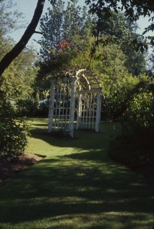
Eagles' garden trellis
https://search.heritageburnaby.ca/link/archivedescription39803
- Repository
- City of Burnaby Archives
- Date
- 1972
- Collection/Fonds
- Burnaby Historical Society fonds
- Description Level
- Item
- Physical Description
- 1 photograph : col. slide ; 5 x 5 cm
- Scope and Content
- Slide of a portion of the Eagles' estate gardens at Deer Lake. These gardens and the home are currently protected as a heritage sites in Burnaby.
- Repository
- City of Burnaby Archives
- Date
- 1972
- Collection/Fonds
- Burnaby Historical Society fonds
- Subseries
- Eagles family subseries
- Physical Description
- 1 photograph : col. slide ; 5 x 5 cm
- Description Level
- Item
- Record No.
- 404-018
- Access Restriction
- No restrictions
- Reproduction Restriction
- Reproduce for fair dealing purposes only
- Accession Number
- BHS2000-4
- Scope and Content
- Slide of a portion of the Eagles' estate gardens at Deer Lake. These gardens and the home are currently protected as a heritage sites in Burnaby.
- Subjects
- Geographic Features - Gardens
- Media Type
- Photograph
- Notes
- Title based on contents of photograph
- Geographic Access
- Sperling Avenue
- Street Address
- 5655 Sperling Avenue
- Historic Neighbourhood
- Burnaby Lake (Historic Neighbourhood)
- Planning Study Area
- Morley-Buckingham Area
Images
![Girl Guide sign, [ca. 1985] thumbnail](/media/hpo/_Data/_BVM_Images/2015/2015_0035_0307_001.jpg?width=280)
Girl Guide sign
https://search.heritageburnaby.ca/link/museumdescription5235
- Repository
- Burnaby Village Museum
- Date
- [ca. 1985]
- Collection/Fonds
- Burnaby Girl Guides fonds
- Description Level
- Item
- Physical Description
- 1 photograph : col. ; 10 x 15 cm
- Scope and Content
- Photograph of a wooden sign in a garden of pink rhododendrums which reads "GIRL GUIDES / 1910-1960 / THANK YOU".This sign was made by Pixie McGeachie who was the District Commissioner for Edmonds. The sign was placed in a garden at Edmonds as part of the 50th Anniversary of Girl Guides.
- Repository
- Burnaby Village Museum
- Collection/Fonds
- Burnaby Girl Guides fonds
- Description Level
- Item
- Physical Description
- 1 photograph : col. ; 10 x 15 cm
- Scope and Content
- Photograph of a wooden sign in a garden of pink rhododendrums which reads "GIRL GUIDES / 1910-1960 / THANK YOU".This sign was made by Pixie McGeachie who was the District Commissioner for Edmonds. The sign was placed in a garden at Edmonds as part of the 50th Anniversary of Girl Guides.
- Accession Code
- BV015.35.307
- Access Restriction
- No restrictions
- Reproduction Restriction
- No known restrictions
- Date
- [ca. 1985]
- Media Type
- Photograph
- Historic Neighbourhood
- Edmonds (Historic Neighbourhood)
- Notes
- Title based on contents of photograph
- See also Original Artifact BV015.35.54
- Photograph was found loose in scrapbook BV015.35.159
Images
![Girl Guide sign, [ca. 1985] thumbnail](/media/hpo/_Data/_BVM_Images/2015/2015_0035_0307_001.jpg)
![Charmaine Yanko (later Bayntun) nursing a goat from a bottle, [1969]. Item no. 549-015. thumbnail](/media/hpo/_Data/_Archives_Images/_Unrestricted/540/549-015.jpg?width=280)
Interview with Charmaine Bayntun by Eric Damer October 22, 2012 - Track 2
https://search.heritageburnaby.ca/link/oralhistory292
- Repository
- City of Burnaby Archives
- Date Range
- 1955-2012
- Length
- 0:09:31
- Summary
- This portion of the recording pertains to Charmaine (Yanko) Bayntun's memories of childhood recreational activities and early friendships. She discusses the canning practices of her family as well.
- Repository
- City of Burnaby Archives
- Summary
- This portion of the recording pertains to Charmaine (Yanko) Bayntun's memories of childhood recreational activities and early friendships. She discusses the canning practices of her family as well.
- Date Range
- 1955-2012
- Photo Info
- Charmaine Yanko (later Bayntun) nursing a goat from a bottle, [1969]. Item no. 549-015.
- Length
- 0:09:31
- Interviewer
- Damer, Eric
- Interview Date
- October 22, 2012
- Scope and Content
- Recording is an interview with Charmaine (Yanko) Bayntun conducted by Burnaby Village Museum employee Eric Damer, October 22, 2012. Major themes discussed are: education and family heritage.
- Biographical Notes
- At the age of twenty, John Ivan Yanko met his future wife Leida Doria "Lillian Doris" Carman while visiting relatives in Burnaby. Lillian received a rail pass because of her dad’s employment with the CPR and at fourteen had gone to visit her Godmother in Burnaby. John Ivan Yanko and Lillian Doris (Carman) Yanko were married October 16, 1948 in Nelson, British Columbia and moved into the basement of John’s sister’s house on Union Street. Lillian began working at the downtown Woodward’s store as a cashier in 1948. In 1950, the young couple bought property at 7385 (later renumbered 7391) Broadway in Burnaby and began constructing a house as they could afford it. Knowing she’d be let go if she was pregnant, when Lillian was expecting her first child, Jenny sewed her several versions of the same outfit; they all used the same material, but each was a little bit larger than the last to accommodate her expanding girth. Rhonda, born in 1953 and Charmaine, born in 1955, grew up in the Broadway home. They attended school at Sperling Elementary, and later at Burnaby North high school. Lillian left her job to be a stay-at-home mom when Rhonda was born, but that changed in 1963 when John and Charmaine were in a car accident that left John temporarily unable to work. John Yanko later returned to work, establishing his own tile setting business and working until age eighty-two. John and Lillian lived out the rest of their married lives on the Broadway property. John Ivan Yanko passed away in 2010; his wife Lillian Doria Leida (Carman) Yanko passed away in 2011. Charmaine (Yanko) Bayntun completed her schooling in Burnaby and became a teacher for twenty-two years, followed by ten years as a Burnaby elementary school principal.
- Total Tracks
- 5
- Total Length
- 0:47:24
- Interviewee Name
- Bayntun, Charmaine "Sherrie" Yanko
- Interview Location
- Burnaby Village Museum
- Interviewer Bio
- Eric Damer is a lifelong British Columbian born in Victoria, raised in Kamloops, and currently residing in Burnaby. After studying philosophy at the University of Victoria, he became interested in the educational forces that had shaped his own life. He completed master’s and doctoral degrees in educational studies at the University of British Columbia with a particular interest in the history of adult and higher education in the province. In 2012, Eric worked for the City of Burnaby as a field researcher and writer, conducting interviews for the City Archives and Museum Oral History Program.
- Collection/Fonds
- Community Heritage Commission Special Projects fonds
- Transcript Available
- None
- Media Type
- Sound Recording
Images
![Charmaine Yanko (later Bayntun) nursing a goat from a bottle, [1969]. Item no. 549-015. thumbnail](/media/hpo/_Data/_Archives_Images/_Unrestricted/540/549-015.jpg)
Audio Tracks
Track two of recording of interview with Charmaine Bayntun
Track two of recording of interview with Charmaine Bayntun
https://search.heritageburnaby.ca/media/hpo/_Data/_Archives_Oral_Histories/_Unrestricted/MSS171-002/MSS171-002_Track_2.mp3Interview with Ken Yip by Eric Damer November 14, 2012 - Track 2
https://search.heritageburnaby.ca/link/oralhistory428
- Repository
- City of Burnaby Archives
- Date Range
- 1947-2012
- Length
- 0:10:24
- Summary
- This portion of the recording pertains to Ken Yip's memories of his family's market garden. Ken describes what work had to be done on the garden, the challenges of owning and operating it, what was grown, and who his family sold to over the years.
- Repository
- City of Burnaby Archives
- Summary
- This portion of the recording pertains to Ken Yip's memories of his family's market garden. Ken describes what work had to be done on the garden, the challenges of owning and operating it, what was grown, and who his family sold to over the years.
- Date Range
- 1947-2012
- Length
- 0:10:24
- Subjects
- Geographic Features - Gardens
- Interviewer
- Damer, Eric
- Interview Date
- November 14, 2012
- Scope and Content
- Recording is an interview with Ken Yip conducted by Burnaby Village Museum employee Eric Damer, November 14, 2012. Major theme discussed: growing up with a family market garden.
- Biographical Notes
- Ken Yip's father purchased property on Byrne Road in the Fraser Arm area of South Burnaby under a special plan granted to veterans of the Second World War, cleared the brush by hand, and enhanced the soil’s productivity to create a market garden. Ken Yip was born in 1949. He and his younger brother grew up at the market garden, helping out. Ken attended Riverside Elementary School, McPherson Park Junior High School and Burnaby South Senior High School where he was in the school band. He continued his studies at the University of British Columbia (UBC) and pursued a career in biomedical engineering.
- Total Tracks
- 8
- Total Length
- 1:09:22
- Interviewee Name
- Yip, Ken
- Interview Location
- Burnaby Village Museum
- Interviewer Bio
- Eric Damer is a lifelong British Columbian born in Victoria, raised in Kamloops, and currently residing in Burnaby. After studying philosophy at the University of Victoria, he became interested in the educational forces that had shaped his own life. He completed master’s and doctoral degrees in educational studies at the University of British Columbia with a particular interest in the history of adult and higher education in the province. In 2012, Eric worked for the City of Burnaby as a field researcher and writer, conducting interviews for the City Archives and Museum Oral History Program.
- Collection/Fonds
- Community Heritage Commission Special Projects fonds
- Transcript Available
- None
- Media Type
- Sound Recording
Audio Tracks
Track two of recording of interview with Ken Yip
Track two of recording of interview with Ken Yip
https://search.heritageburnaby.ca/media/hpo/_Data/_Archives_Oral_Histories/_Unrestricted/MSS171-030/MSS171-030_Track_2.mp3Interview with Ken Yip by Eric Damer November 14, 2012 - Track 3
https://search.heritageburnaby.ca/link/oralhistory429
- Repository
- City of Burnaby Archives
- Date Range
- 1961-1972
- Length
- 0:09:09
- Summary
- This portion of the recording pertains to Ken Yip's memories of his family's market garden. Ken describes how the vegetables were planted, harvested and delivered. He mentions his school days; being part of the high school band and his studies at Riverside School before that.
- Repository
- City of Burnaby Archives
- Summary
- This portion of the recording pertains to Ken Yip's memories of his family's market garden. Ken describes how the vegetables were planted, harvested and delivered. He mentions his school days; being part of the high school band and his studies at Riverside School before that.
- Date Range
- 1961-1972
- Length
- 0:09:09
- Names
- Riverside School
- Subjects
- Geographic Features - Gardens
- Interviewer
- Damer, Eric
- Interview Date
- November 14, 2012
- Scope and Content
- Recording is an interview with Ken Yip conducted by Burnaby Village Museum employee Eric Damer, November 14, 2012. Major theme discussed: growing up with a family market garden.
- Biographical Notes
- Ken Yip's father purchased property on Byrne Road in the Fraser Arm area of South Burnaby under a special plan granted to veterans of the Second World War, cleared the brush by hand, and enhanced the soil’s productivity to create a market garden. Ken Yip was born in 1949. He and his younger brother grew up at the market garden, helping out. Ken attended Riverside Elementary School, McPherson Park Junior High School and Burnaby South Senior High School where he was in the school band. He continued his studies at the University of British Columbia (UBC) and pursued a career in biomedical engineering.
- Total Tracks
- 8
- Total Length
- 1:09:22
- Interviewee Name
- Yip, Ken
- Interview Location
- Burnaby Village Museum
- Interviewer Bio
- Eric Damer is a lifelong British Columbian born in Victoria, raised in Kamloops, and currently residing in Burnaby. After studying philosophy at the University of Victoria, he became interested in the educational forces that had shaped his own life. He completed master’s and doctoral degrees in educational studies at the University of British Columbia with a particular interest in the history of adult and higher education in the province. In 2012, Eric worked for the City of Burnaby as a field researcher and writer, conducting interviews for the City Archives and Museum Oral History Program.
- Collection/Fonds
- Community Heritage Commission Special Projects fonds
- Transcript Available
- None
- Media Type
- Sound Recording
Audio Tracks
Track three of recording of interview with Ken Yip
Track three of recording of interview with Ken Yip
https://search.heritageburnaby.ca/media/hpo/_Data/_Archives_Oral_Histories/_Unrestricted/MSS171-030/MSS171-030_Track_3.mp3Interview with Ken Yip by Eric Damer November 14, 2012 - Track 8
https://search.heritageburnaby.ca/link/oralhistory434
- Repository
- City of Burnaby Archives
- Date Range
- 1947-2012
- Length
- 0:08:44
- Summary
- This portion of the recording pertains to Ken Yip's memories of growing up on a market garden. Ken discusses how Burnaby changed from the time of his childhood and the values he gained from his involvement with the family market garden.
- Repository
- City of Burnaby Archives
- Summary
- This portion of the recording pertains to Ken Yip's memories of growing up on a market garden. Ken discusses how Burnaby changed from the time of his childhood and the values he gained from his involvement with the family market garden.
- Date Range
- 1947-2012
- Length
- 0:08:44
- Subjects
- Geographic Features - Gardens
- Interviewer
- Damer, Eric
- Interview Date
- November 14, 2012
- Scope and Content
- Recording is an interview with Ken Yip conducted by Burnaby Village Museum employee Eric Damer, November 14, 2012. Major theme discussed: growing up with a family market garden.
- Biographical Notes
- Ken Yip's father purchased property on Byrne Road in the Fraser Arm area of South Burnaby under a special plan granted to veterans of the Second World War, cleared the brush by hand, and enhanced the soil’s productivity to create a market garden. Ken Yip was born in 1949. He and his younger brother grew up at the market garden, helping out. Ken attended Riverside Elementary School, McPherson Park Junior High School and Burnaby South Senior High School where he was in the school band. He continued his studies at the University of British Columbia (UBC) and pursued a career in biomedical engineering.
- Total Tracks
- 8
- Total Length
- 1:09:22
- Interviewee Name
- Yip, Ken
- Interview Location
- Burnaby Village Museum
- Interviewer Bio
- Eric Damer is a lifelong British Columbian born in Victoria, raised in Kamloops, and currently residing in Burnaby. After studying philosophy at the University of Victoria, he became interested in the educational forces that had shaped his own life. He completed master’s and doctoral degrees in educational studies at the University of British Columbia with a particular interest in the history of adult and higher education in the province. In 2012, Eric worked for the City of Burnaby as a field researcher and writer, conducting interviews for the City Archives and Museum Oral History Program.
- Collection/Fonds
- Community Heritage Commission Special Projects fonds
- Transcript Available
- None
- Media Type
- Sound Recording
Audio Tracks
Track eight of recording of interview with Ken Yip
Track eight of recording of interview with Ken Yip
https://search.heritageburnaby.ca/media/hpo/_Data/_Archives_Oral_Histories/_Unrestricted/MSS171-030/MSS171-030_Track_8.mp3
Looking south from 5496 Dominion Street
https://search.heritageburnaby.ca/link/archivedescription91863
- Repository
- City of Burnaby Archives
- Date
- September 1984
- Collection/Fonds
- Small family fonds
- Description Level
- Item
- Physical Description
- 1 photograph : col. ; 10 cm x 15 cm
- Scope and Content
- Photograph of the backyard at 5496 Dominion Street. Beyond the fence, the double garage built at 5495 Norfolk Street (right) and the original house at 5511 Norfolk Street (left) are visible. The photograph was taken from 5496 Dominion Street, looking south.
- Repository
- City of Burnaby Archives
- Date
- September 1984
- Collection/Fonds
- Small family fonds
- Physical Description
- 1 photograph : col. ; 10 cm x 15 cm
- Description Level
- Item
- Record No.
- 620-044
- Access Restriction
- No restrictions
- Reproduction Restriction
- No reproduction permitted
- Accession Number
- 2017-01
- Scope and Content
- Photograph of the backyard at 5496 Dominion Street. Beyond the fence, the double garage built at 5495 Norfolk Street (right) and the original house at 5511 Norfolk Street (left) are visible. The photograph was taken from 5496 Dominion Street, looking south.
- Media Type
- Photograph
- Notes
- Transcribed title
- Title transcribed from donor's notes
- Note in blue ink on verso of photograph reads: "P7"
- Note in black ink on verso of photograph reads: "5496 Dominion St. / Burnaby, B.C. / Sept. 1984"
- 5495 Norfolk Street was previously numbered 3155 Norfolk Street. The property was later subdivided into two lots: 5491 and 5497 Norfolk Street.
- 5511 Norfolk Street was previously numbered 3149 Norfolk Street. The property was later subdivided into two lots: 5503 and 5521 Norfolk Street.
- Street Address
- 5495 Norfolk Street
- 5496 Dominion Street
- 5511 Norfolk Street
- Historic Neighbourhood
- Burnaby Lake (Historic Neighbourhood)
- Planning Study Area
- Ardingley-Sprott Area
Images


Looking south from 5496 Dominion Street
https://search.heritageburnaby.ca/link/archivedescription91864
- Repository
- City of Burnaby Archives
- Date
- July 1989
- Collection/Fonds
- Small family fonds
- Description Level
- Item
- Physical Description
- 1 photograph : col. ; 10 cm x 15 cm
- Scope and Content
- Photograph of the backyard at 5496 Dominion Street. The backyard landscaping includes a cement pathway and vegetable garden. The photograph was taken from 5496 Dominion Street, looking south.
- Repository
- City of Burnaby Archives
- Date
- July 1989
- Collection/Fonds
- Small family fonds
- Physical Description
- 1 photograph : col. ; 10 cm x 15 cm
- Description Level
- Item
- Record No.
- 620-045
- Access Restriction
- No restrictions
- Reproduction Restriction
- No reproduction permitted
- Accession Number
- 2017-01
- Scope and Content
- Photograph of the backyard at 5496 Dominion Street. The backyard landscaping includes a cement pathway and vegetable garden. The photograph was taken from 5496 Dominion Street, looking south.
- Media Type
- Photograph
- Notes
- Transcribed title
- Title transcribed from donor's notes
- Note in blue ink on verso of photograph reads: "P8"
- Note in black ink on verso of photograph reads: "July 1989"
- Street Address
- 5496 Dominion Street
- Historic Neighbourhood
- Burnaby Lake (Historic Neighbourhood)
- Planning Study Area
- Ardingley-Sprott Area
Images
