Narrow Results By
Decade
- 2020s 4
- 2010s 4
- 2000s 109
- 1990s 115
- 1980s 123
- 1970s 344
- 1960s
- 1950s 156
- 1940s 91
- 1930s 114
- 1920s 107
- 1910s 105
- 1900s 40
- 1890s 22
- 1880s 9
- 1870s 4
- 1860s 5
- 1850s 2
- 1840s 1
- 1830s 1
- 1820s 1
- 1810s 2
- 1800s 2
- 1790s 2
- 1780s 2
- 1770s 2
- 1760s 2
- 1750s 2
- 1740s 2
- 1730s 2
- 1720s 2
- 1710s 2
- 1700s 2
- 1690s 2
- 1680s 2
- 1670s 1
- 1660s 1
- 1650s 1
- 1640s 1
- 1630s 1
- 1620s 1
- 1610s 1
- 1600s 1
- 1590s 1
- 1580s 1
- 1570s 1
- 1560s 1
- 1550s 1
- 1540s 1
- 1530s 1
- 1520s 1
- 1510s 1
- 1500s 1
- 1490s 1
- 1480s 1
![Sambo's Pancake House, [196-] thumbnail](/media/hpo/_Data/_Archives_Images/_Unrestricted/126/201-001.jpg?width=280)
Sambo's Pancake House
https://search.heritageburnaby.ca/link/archivedescription35138
- Repository
- City of Burnaby Archives
- Date
- [196-]
- Collection/Fonds
- Burnaby Historical Society fonds
- Description Level
- Item
- Physical Description
- 1 photograph : col. postcard ; 8.9 x 14.0 cm
- Scope and Content
- Photographic postcard of the exterior and parking lot of Sambo's Pancake House, Kingsway. Printed on the top of the front of the postcard is "Sambo's Pancake House," and a sign on the building read's "Sambo's." Written on the back of the postcard: "Please surrender this card for 10% discount on you…
- Repository
- City of Burnaby Archives
- Date
- [196-]
- Collection/Fonds
- Burnaby Historical Society fonds
- Subseries
- Photographs subseries
- Physical Description
- 1 photograph : col. postcard ; 8.9 x 14.0 cm
- Description Level
- Item
- Record No.
- 201-001
- Access Restriction
- No restrictions
- Reproduction Restriction
- Reproduce for fair dealing purposes only
- Accession Number
- BHS1987-10
- Scope and Content
- Photographic postcard of the exterior and parking lot of Sambo's Pancake House, Kingsway. Printed on the top of the front of the postcard is "Sambo's Pancake House," and a sign on the building read's "Sambo's." Written on the back of the postcard: "Please surrender this card for 10% discount on your next visit to Sambo's, 5550 Kingsway, Burnaby. Offer good until Feb. 28th, 1969. Your host Sambo's."
- Subjects
- Geographic Features - Automobile Parking Lots
- Documentary Artifacts - Postcards
- Buildings - Commercial - Restaurants
- Names
- Sambo's Pancake House
- Media Type
- Photograph
- Notes
- Title based on contents of photograph
- Geographic Access
- Kingsway
- Street Address
- 5550 Kingsway
- Historic Neighbourhood
- Central Park (Historic Neighbourhood)
- Planning Study Area
- Windsor Area
Images
![Sambo's Pancake House, [196-] thumbnail](/media/hpo/_Data/_Archives_Images/_Unrestricted/126/201-001.jpg)

Dr. William & Ruth Baldwin House
https://search.heritageburnaby.ca/link/landmark534
- Repository
- Burnaby Heritage Planning
- Description
- The Dr. William & Ruth Baldwin House is a two-storey modern post-and-beam structure, located on the southern shore of Deer Lake in Burnaby's Deer Lake Park. The site is steeply sloped, and the main entrance of the house is at the top of the slope facing onto Deer Lake Drive.
- Associated Dates
- 1965
- Formal Recognition
- Community Heritage Register
- Repository
- Burnaby Heritage Planning
- Geographic Access
- Deer Lake Drive
- Associated Dates
- 1965
- Formal Recognition
- Community Heritage Register
- Enactment Type
- Council Resolution
- Enactment Date
- 26/05/2003
- Description
- The Dr. William & Ruth Baldwin House is a two-storey modern post-and-beam structure, located on the southern shore of Deer Lake in Burnaby's Deer Lake Park. The site is steeply sloped, and the main entrance of the house is at the top of the slope facing onto Deer Lake Drive.
- Heritage Value
- The Baldwin House is valued as a prime example of Burnaby’s post-Second World War modern heritage and progressive architectural style, as well as for its personal connections to internationally-acclaimed architect, Arthur Erickson. Inspired by the modern domestic idiom established earlier in the twentieth century by Frank Lloyd Wright and Richard Neutra, Erickson conceived his architecture as responding directly to the site. A cohesive expression of simple orthogonal lines and ultimate transparency, this structure reduces the idea of post-and-beam West Coast modernism to its most refined elements. A fine example of the evolving talent of Erickson’s earlier work, this house is a landmark modern house in Burnaby and is unique in terms of siting and context. Having just won the 1963 competition for the new Simon Fraser University in Burnaby with his partner, Geoff Massey, and having built fewer than half a dozen homes previously, Erickson’s reputation was growing and his skill as a designer of modern buildings was in great demand. The same year that Erickson/Massey Architects designed SFU, Dr. William Baldwin and his wife, Ruth, personal friends of Erickson, commissioned him to design this house. Erickson was already familiar with the site; as a child he had spent time at this spot when his family visited friends who lived on Deer Lake. Both the Baldwin House and the university were completed in 1965. SFU became internationally famous; the Baldwin House was also considered an architectural success and was recognized in publications of the time. Only a single storey of this two-storey house is visible from the road, as it is built into the hillside in response to its steep site and proximity to Deer Lake. Like many other Erickson designs, this structure was conceived as a pavilion. Constructed of glass and wood, its transparency facilitates visual access to the lake’s edge, acting as an invitation, rather than a barrier, to the landscape. The house blends into the natural surroundings and the site includes other man-made landscape features such as a reflecting pool. As a reaction to the often grey quality of light in the region, Erickson exploits flat planes of water as a source of borrowed light. The refined and purposeful design, transparency, openness of plan and adjacency to the lake combine to give the house a floating appearance at the water's edge. The concept of a floating house set within an accompanying garden was inspired, in part, by the palaces and house boats of Dal Lake in Kashmir and the famed nearby Mughal Gardens. Although Erickson never visited Dal Lake, he travelled extensively throughout India, and specifically mentions the Kashmir reference in relation to this house. There is a rich complexity of other allusions worked into the fabric of the house, unified by a feeling for the conjunction of light, water and land at this special location. Widely renowned as Canada’s most brilliant modern architect, Erickson’s reputation is important to the development and growth of modern architecture in Canada and North America.
- Defining Elements
- The elements of the Baldwin House that define its character are those materials and details which respond to the location of the building and determine the relation between landscape and building, combining to create a single cohesive site. These include its: - close proximity to water - orthogonal plan and massing, with flat tar-and-gravel roof - stepped down massing orienting the house towards the water - post-and-beam construction, with the width of the beams matched to the width of the posts - wood and glass used as primary building materials - transparency and light achieved by the abundant use of glass - large undivided sheets of single glazing - butt glazed glass corners - abundant and generous balconies, which blur the transition from interior to exterior - horizontal flush cedar siding - use of salvaged brick for chimneys - use of chains as downspouts - built-in rooftop barbeque - built in furniture and fittings dating to the time of construction, such as original hardware, benches, bathroom vanities and kitchen cabinets - landscaped site including reflecting pool, plantings and a dock protruding into the lake
- Locality
- Deer Lake Park
- Historic Neighbourhood
- Burnaby Lake (Historic Neighbourhood)
- Planning Study Area
- Morley-Buckingham Area
- Function
- Primary Current--Single Dwelling
- Primary Historic--Single Dwelling
- Community
- Burnaby
- Cadastral Identifier
- P.I.D. No. 011-946-032 and P.I.D. No. 011-946-067
- Boundaries
- The Baldwin House is comprised of two municipally-owned lots located at 6543 and 6545 Deer Lake Drive, Burnaby.
- Area
- 6,070.20
- Contributing Resource
- Building
- Landscape Feature
- Ownership
- Public (local)
- Other Collection
- Canadian Architectural Archives, University of Calgary, Collection: Original Plans No. ERI 4A/76.13
- Documentation
- Heritage Site Files: PC77000 20. City of Burnaby Planning and Building Department, 4949 Canada Way, Burnaby, B.C., V5G 1M2
- Street Address
- 6543 Deer Lake Drive
Images


Bill Copeland Sports Centre & Burnaby Lake Arena
https://search.heritageburnaby.ca/link/landmark819
- Repository
- Burnaby Heritage Planning
- Geographic Access
- Kensington Avenue
- Associated Dates
- 1965
- Heritage Value
- In February 1965, the Planning Department presented to Burnaby Council a preliminary Development Plan entitled "Pacific Sports Centre," for the area immediately west of Burnaby Lake. This report proposed a conceptual plan for a comprehensive range of indoor and outdoor sporting facilities adjacent to Burnaby Lake. The idea was accepted by Council and led to the construction of the Burnaby Lake Rink beside the C.G. Brown Pool. In 1973, Burnaby and New Westminster jointly hosted the Canada Summer Games for which a rowing course and pavilion were built at Burnaby Lake and the success of the games and the sports facilities added within Burnaby Lake Park provided further stimulus for the creation of the sports and recreation facilities at this site.
- Historic Neighbourhood
- Burnaby Lake (Historic Neighbourhood)
- Planning Study Area
- Ardingley-Sprott Area
- Street Address
- 3676 Kensington Avenue
- Street View URL
- Google Maps Street View
Images


British Columbia Institute of Technology (BCIT)
https://search.heritageburnaby.ca/link/landmark806
- Repository
- Burnaby Heritage Planning
- Geographic Access
- Willingdon Avenue
- Associated Dates
- 1960
- Heritage Value
- The BC Vocational School was established in 1960 at Willingdon and Canada Way. By 1964, the British Columbia Insitute of Technology had opened and had 498 students enrolled. In the 1970s, the BC Vocational School had been renamed the Pacific Vocational Institute and in 1986 the two institutions merged. The school is a public post-secondary institution that is governed by a Board of Governors, under the authority of the Ministry of Advanced Education, Training and Technology. By 2004, the annual enrolment of part-time and full-time students reached 48,000.
- Planning Study Area
- Douglas-Gilpin Area
- Street Address
- 3700 Willingdon Avenue
- Street View URL
- Google Maps Street View
Images


Douglas-Gilpin Neighbourhood
https://search.heritageburnaby.ca/link/landmark799
- Repository
- Burnaby Heritage Planning
- Associated Dates
- 1955-2008
- Heritage Value
- The Douglas-Gilpin Neighbourhood developed into a diverse area incorporating residential, business, educational and park districts in the period after 1955. The BCIT site was built in the early 1960s, shortly after the Burnaby Municipal Hall was located on Canada Way near Deer Lake in 1956. The construction of the Municipal Hall at this location fostered the creation of an administrative and business centre adjacent to the park, while the northern and central areas of the neighbourhood retained their primarily residential character.
- Historic Neighbourhood
- Burnaby Lake (Historic Neighbourhood)
- Planning Study Area
- Douglas-Gilpin Area
Images


Lake City Neighbourhood
https://search.heritageburnaby.ca/link/landmark793
- Repository
- Burnaby Heritage Planning
- Associated Dates
- 1955-2008
- Heritage Value
- When Simon Fraser University opened in 1965, approximately sixteen industrial properties had been developed in the Lake City Industrial Park. In addition, significant tracts of land in the western portion had been pre-cleared and graded in anticipation of additional development, while most of the eastern half remained forested. Some of the early companies to locate in the area were Nabob Foods, Volkswagen Canada, British Columbia Television Broadcasting, Simpson Sears, and H.Y. Louie Company Limited. Both Imperial Oil and Shell Oil established petroleum storage and distribution facilities in the area. Initially a heavy industrial area, by 1979, single family neighbourhoods south of Lougheed Highway and west of Eagle Creek had been largely developed. By the mid1980's, the Burnaby 200 multi-family development along Forest Grove Drive had also been completed.
- Planning Study Area
- Lake City Area
Images


Morley-Buckingham Neighbourhood
https://search.heritageburnaby.ca/link/landmark829
- Repository
- Burnaby Heritage Planning
- Associated Dates
- 1955-2008
- Heritage Value
- In the 1980 "Residential Neighbourhood Environment Study," the Morley-Buckingham Neighbourhood is described as "perhaps Burnaby's most prestigious residential area. The lots are larger than most other areas of the Municipality and this, along with the new expensive housing developed over the past 10 years, has created a very desirable residential neighbourhood...The older area of Buckingham lies at the lower edge of the slope and here the homes and streets are more uniform and aged between 20 and 25 years old...to the east of Canada Way lies...a cluster townhouse development."
- Historic Neighbourhood
- Burnaby Lake (Historic Neighbourhood)
- Planning Study Area
- Morley-Buckingham Area
Images


Willingdon Heights Neighbourhood
https://search.heritageburnaby.ca/link/landmark777
- Repository
- Burnaby Heritage Planning
- Associated Dates
- 1955-2008
- Heritage Value
- The convenient location of Willingdon Heights to the Trans Canada Highway, Lougheed Highway and Hastings Street has fostered its development as a primarily residential commuter neighbourhood. Characterised in the post-World War Two period by predominantly single-family developments, the neighbourhood has retained this identity despite some higher density apartment buildings now found there.
- Planning Study Area
- Willingdon Heights Area
Images

![Brentwood Shopping Centre, [196-] thumbnail](/media/hpo/_Data/_Archives_Images/_Unrestricted/126/195-002.jpg?width=280)
Brentwood Shopping Centre
https://search.heritageburnaby.ca/link/archivedescription35132
- Repository
- City of Burnaby Archives
- Date
- [196-]
- Collection/Fonds
- Burnaby Historical Society fonds
- Description Level
- Item
- Physical Description
- 1 photograph : col. postcard ; 8.9 x 14.0 cm
- Scope and Content
- Postcard cosisting of four photographs of Brentwood Shopping Centre. The description printed on the back of the postcard reads, "Brentwood Shopping Centre / Lougheed and Willingdon, Burnaby, B.C. Free parking for 2500 cars. Eaton's of Canada - three floors of air-conditioned shopping comfort. Fo…
- Repository
- City of Burnaby Archives
- Date
- [196-]
- Collection/Fonds
- Burnaby Historical Society fonds
- Subseries
- Evelyn Salisbury subseries
- Physical Description
- 1 photograph : col. postcard ; 8.9 x 14.0 cm
- Description Level
- Item
- Record No.
- 195-002
- Access Restriction
- No restrictions
- Reproduction Restriction
- Reproduce for fair dealing purposes only
- Accession Number
- BHS1987-04
- Scope and Content
- Postcard cosisting of four photographs of Brentwood Shopping Centre. The description printed on the back of the postcard reads, "Brentwood Shopping Centre / Lougheed and Willingdon, Burnaby, B.C. Free parking for 2500 cars. Eaton's of Canada - three floors of air-conditioned shopping comfort. Fountain Square. Loblaw's ... B.C.'s Largest Supermarket." The cost to mail the postcard is listed as four cents. Some of the stores visible are: Bank of Montreal, Heywood Floors, The Doll House Restaurant, Eaton's of Canada, Loblaws, Fields, and Zeller's.
- Subjects
- Geographic Features - Automobile Parking Lots
- Fountains
- Documentary Artifacts - Postcards
- Buildings - Commercial - Malls
- Media Type
- Photograph
- Photographer
- Ford, Rolly
- Notes
- Title based on contents of photograph
- Geographic Access
- Lougheed Highway
- Street Address
- 4567 Lougheed Highway
- Planning Study Area
- Brentwood Area
Images
![Brentwood Shopping Centre, [196-] thumbnail](/media/hpo/_Data/_Archives_Images/_Unrestricted/126/195-002.jpg)
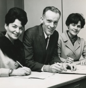
Bob Prittie, Caroline Prior and Del Carrell
https://search.heritageburnaby.ca/link/archivedescription46022
- Repository
- City of Burnaby Archives
- Date
- November 1968
- Collection/Fonds
- Columbian Newspaper collection
- Description Level
- Item
- Physical Description
- 1 photograph : b&w ; 14 x 14 cm
- Scope and Content
- Photograph of Burnaby Citizen's Association candidates; school board trustee Caroline Prior, Mayor Bob Prittie, and aldermanic candidate Del Carrell filing civic election nomination papers at City Hall.
- Repository
- City of Burnaby Archives
- Date
- November 1968
- Collection/Fonds
- Columbian Newspaper collection
- Physical Description
- 1 photograph : b&w ; 14 x 14 cm
- Description Level
- Item
- Record No.
- 480-910
- Access Restriction
- No restrictions
- Reproduction Restriction
- Reproduce for fair dealing purposes only
- Accession Number
- 2003-02
- Scope and Content
- Photograph of Burnaby Citizen's Association candidates; school board trustee Caroline Prior, Mayor Bob Prittie, and aldermanic candidate Del Carrell filing civic election nomination papers at City Hall.
- Names
- Prittie, Robert W. "Bob"
- Prior, Caroline
- Carrell, Del
- Burnaby Citizens Association
- Burnaby School Trustees
- Media Type
- Photograph
- Notes
- Title based on contents of photograph
- Newspaper clipping attached to verso of photograph reads: "Filing civic election nomination papers at municipal hall are BCA candidates Mrs. Caroline Prior, incumbent school board trustee; mayoralty [sic] candidate Robert Prittie, and aldermanic candidate Mrs. Del Carrell."
- Geographic Access
- Canada Way
- Street Address
- 4949 Canada Way
- Historic Neighbourhood
- Burnaby Lake (Historic Neighbourhood)
- Planning Study Area
- Douglas-Gilpin Area
Images

![Bruce Northorp and Robert Prittie, [between 1969 and 1973] thumbnail](/media/hpo/_Data/_Archives_Images/_Unrestricted/480/480-1098.jpg?width=280)
Bruce Northorp and Robert Prittie
https://search.heritageburnaby.ca/link/archivedescription46210
- Repository
- City of Burnaby Archives
- Date
- [between 1969 and 1973]
- Collection/Fonds
- Columbian Newspaper collection
- Description Level
- Item
- Physical Description
- 1 photograph : b&w ; 19.5 x 24.5 cm
- Scope and Content
- Photograph of Royal Canadian Mounted Police staff-sergeant Bruce Northorp in uniform, shaking hands with Burnaby Mayor Robert Prittie, as the Mayor presents him with the RCMP's 20-year long-service metal at a ceremony at city hall.
- Repository
- City of Burnaby Archives
- Date
- [between 1969 and 1973]
- Collection/Fonds
- Columbian Newspaper collection
- Physical Description
- 1 photograph : b&w ; 19.5 x 24.5 cm
- Description Level
- Item
- Record No.
- 480-1098
- Access Restriction
- No restrictions
- Reproduction Restriction
- Reproduce for fair dealing purposes only
- Accession Number
- 2003-02
- Scope and Content
- Photograph of Royal Canadian Mounted Police staff-sergeant Bruce Northorp in uniform, shaking hands with Burnaby Mayor Robert Prittie, as the Mayor presents him with the RCMP's 20-year long-service metal at a ceremony at city hall.
- Subjects
- Clothing - Uniforms
- Public Services - Policing
- Ceremonies - Awards
- Personal Symbols - Certificates
- Officials - Mayors and Reeves
- Media Type
- Photograph
- Notes
- Title based on contents of photograph
- Geographic Access
- Canada Way
- Street Address
- 4949 Canada Way
- Historic Neighbourhood
- Burnaby Lake (Historic Neighbourhood)
- Planning Study Area
- Douglas-Gilpin Area
Images
![Bruce Northorp and Robert Prittie, [between 1969 and 1973] thumbnail](/media/hpo/_Data/_Archives_Images/_Unrestricted/480/480-1098.jpg)
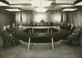
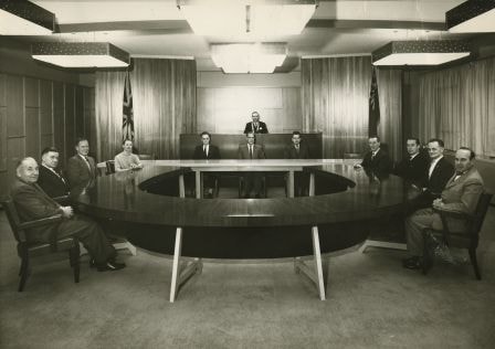
Burnaby Council Members, 1960
https://search.heritageburnaby.ca/link/archivedescription34698
- Repository
- City of Burnaby Archives
- Date
- 1960
- Collection/Fonds
- Burnaby Historical Society fonds
- Description Level
- Item
- Physical Description
- 1 photograph : b&w ; 19.1 x 25.3 cm
- Scope and Content
- Photograph of Burnaby Municipal Council and staff seated in the Council Chambers at the Municipal Hall, 4949 Canada Way. Councillors, anti-clockwise starting at upper left: Camille Mather, Malcolm J. Harper, John D. Drummond, Charles W. MacSorley, Donald H. Jamieson, Russell E. Hicks, James H. Edwa…
- Repository
- City of Burnaby Archives
- Date
- 1960
- Collection/Fonds
- Burnaby Historical Society fonds
- Subseries
- Photographs subseries
- Physical Description
- 1 photograph : b&w ; 19.1 x 25.3 cm
- Description Level
- Item
- Record No.
- 103-001
- Access Restriction
- No restrictions
- Reproduction Restriction
- Reproduce for fair dealing purposes only
- Accession Number
- BHS2007-04
- Scope and Content
- Photograph of Burnaby Municipal Council and staff seated in the Council Chambers at the Municipal Hall, 4949 Canada Way. Councillors, anti-clockwise starting at upper left: Camille Mather, Malcolm J. Harper, John D. Drummond, Charles W. MacSorley, Donald H. Jamieson, Russell E. Hicks, James H. Edwards, and Robert W. Prittie. Staff, seated at table at back, left to right: J.H. Shaw (Clerk), H.W. Balfour (Manager), and S.B. McCafferty (Treasurer). Reeve Alan H. Emmott is seated on the dias.
- Subjects
- Officials - Alderman and Councillors
- Buildings - Civic - City Halls
- Officials - Mayors and Reeves
- Occupations - Civic Workers
- Occupations - City Clerks
- Names
- Balfour, H.W.
- Drummond, John D. "Doug"
- Edwards, James H.
- Emmott, Alan H.
- Harper, Malcolm J.
- Hicks, Russell E.
- Jamieson, Donald H
- MacSorley, Charles W.
- Mather, Camille
- McCafferty, S.B. "Bart"
- Prittie, Robert W. "Bob"
- Shaw, John Horace "Jack"
- Burnaby City Hall
- Media Type
- Photograph
- Photographer
- LeBlanc, Don
- Notes
- Annotation at bottom of photograph reads, "Burnaby Council Members - 1960"
- Stamp and annotation on back of photograph reads, "Croton Studio / Don Leblanc / Middlegate Shopping Centre, 406-7155 Kingsway, South Burnaby B.C. / Lakeview 2-2848 / File Number: 1114, Negative Number: 2"
- Geographic Access
- Canada Way
- Street Address
- 4949 Canada Way
- Historic Neighbourhood
- Burnaby Lake (Historic Neighbourhood)
- Planning Study Area
- Douglas-Gilpin Area
Images
![Burnaby Winter Club, [1963] thumbnail](/media/hpo/_Data/_Archives_Images/_Unrestricted/001/068-001.jpg?width=280)
Burnaby Winter Club
https://search.heritageburnaby.ca/link/archivedescription34632
- Repository
- City of Burnaby Archives
- Date
- [1963]
- Collection/Fonds
- Burnaby Historical Society fonds
- Description Level
- Item
- Physical Description
- 1 photograph : b&w ; 17.5 x 19.7 cm
- Scope and Content
- Photograph of the Burnaby Winter Club at 4990 Canada Way. Three sheep and a horse are standing in a field by a building.
- Repository
- City of Burnaby Archives
- Date
- [1963]
- Collection/Fonds
- Burnaby Historical Society fonds
- Subseries
- Photographs subseries
- Physical Description
- 1 photograph : b&w ; 17.5 x 19.7 cm
- Description Level
- Item
- Record No.
- 068-001
- Access Restriction
- No restrictions
- Reproduction Restriction
- Reproduce for fair dealing purposes only
- Accession Number
- BHS2007-04
- Scope and Content
- Photograph of the Burnaby Winter Club at 4990 Canada Way. Three sheep and a horse are standing in a field by a building.
- Names
- Burnaby Winter Club
- Media Type
- Photograph
- Notes
- Title based on contents of photograph
- Geographic Access
- Canada Way
- Street Address
- 4990 Canada Way
- Historic Neighbourhood
- Burnaby Lake (Historic Neighbourhood)
- Planning Study Area
- Douglas-Gilpin Area
Images
![Burnaby Winter Club, [1963] thumbnail](/media/hpo/_Data/_Archives_Images/_Unrestricted/001/068-001.jpg)
![Canadian Flag raising, [196-] thumbnail](/media/hpo/_Data/_Archives_Images/_Unrestricted/316/366-040-4.jpg?width=280)
Canadian Flag raising
https://search.heritageburnaby.ca/link/archivedescription97625
- Repository
- City of Burnaby Archives
- Date
- [196-]
- Collection/Fonds
- Burnaby Historical Society fonds
- Description Level
- File
- Physical Description
- 6 photographs : b&w negatives
- Scope and Content
- Photographs of a Canadian flag raising ceremony at Burnaby Municipal Hall.
- Repository
- City of Burnaby Archives
- Date
- [196-]
- Collection/Fonds
- Burnaby Historical Society fonds
- Subseries
- Municipal record subseries
- Physical Description
- 6 photographs : b&w negatives
- Description Level
- File
- Record No.
- 366-040
- Access Restriction
- No restrictions
- Reproduction Restriction
- Reproduce for fair dealing purposes only
- Accession Number
- BHS1998-12
- Scope and Content
- Photographs of a Canadian flag raising ceremony at Burnaby Municipal Hall.
- Subjects
- Ceremonial Artifacts - Flags
- Media Type
- Photograph
- Notes
- Title based on content of photographs
- Geographic Access
- Canada Way
- Street Address
- 4949 Canada Way
- Historic Neighbourhood
- Vancouver Heights (Historic Neighbourhood)
- Planning Study Area
- Burnaby Heights Area
Images
![Canadian Flag raising, [196-] thumbnail](/media/hpo/_Data/_Archives_Images/_Unrestricted/316/366-040-4.jpg)
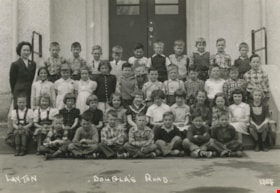
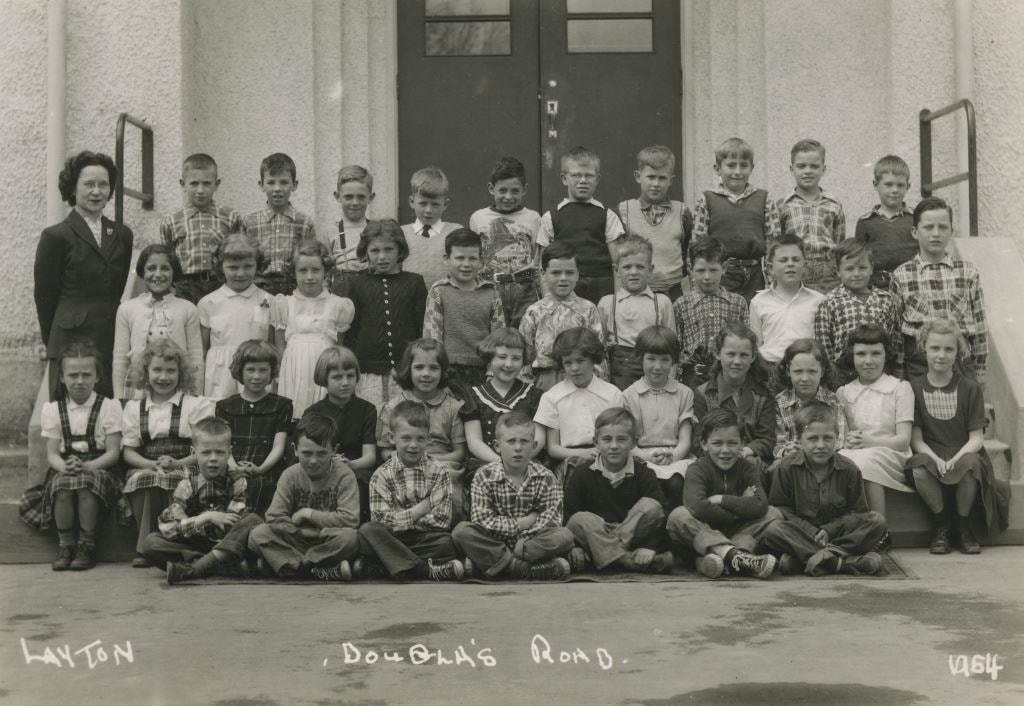
Douglas Road
https://search.heritageburnaby.ca/link/archivedescription36053
- Repository
- City of Burnaby Archives
- Date
- 1964
- Collection/Fonds
- Burnaby Historical Society fonds
- Description Level
- Item
- Physical Description
- 1 photograph : b&w ; 11.5 x 16 cm
- Scope and Content
- Photograph of Marietta Ketchum (far left) and her class at Douglas Road School lined up in rows on the steps of the school.
- Repository
- City of Burnaby Archives
- Date
- 1964
- Collection/Fonds
- Burnaby Historical Society fonds
- Subseries
- Grace Dickie subseries
- Physical Description
- 1 photograph : b&w ; 11.5 x 16 cm
- Material Details
- Photographer wrote their name and the date on the negative, making both white on the photograph
- Description Level
- Item
- Record No.
- 215-011
- Access Restriction
- No restrictions
- Reproduction Restriction
- Reproduce for fair dealing purposes only
- Accession Number
- BHS1989-03
- Scope and Content
- Photograph of Marietta Ketchum (far left) and her class at Douglas Road School lined up in rows on the steps of the school.
- Subjects
- Occupations - Teachers
- Media Type
- Photograph
- Notes
- Photographer identified as "Layton"
- Geographic Access
- Canada Way
- Street Address
- 4861 Canada Way
- Historic Neighbourhood
- Burnaby Lake (Historic Neighbourhood)
- Planning Study Area
- Douglas-Gilpin Area
Images
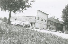
Douglas Road School gymnasium
https://search.heritageburnaby.ca/link/archivedescription38648
- Repository
- City of Burnaby Archives
- Date
- 1960
- Collection/Fonds
- Burnaby Historical Society fonds
- Description Level
- Item
- Physical Description
- 1 photograph : b&w ; 10 x 15 cm
- Scope and Content
- Photograph of two workmen (unidentified) standing next to a truckload of lumber outside the new Douglas Road School gymnasium.
- Repository
- City of Burnaby Archives
- Date
- 1960
- Collection/Fonds
- Burnaby Historical Society fonds
- Subseries
- Douglas Road School subseries
- Physical Description
- 1 photograph : b&w ; 10 x 15 cm
- Description Level
- Item
- Record No.
- 471-009
- Access Restriction
- No restrictions
- Reproduction Restriction
- Reproduce for fair dealing purposes only
- Accession Number
- BHS2005-3
- Scope and Content
- Photograph of two workmen (unidentified) standing next to a truckload of lumber outside the new Douglas Road School gymnasium.
- Names
- Douglas Road School
- Media Type
- Photograph
- Photographer
- Gordon, Ethel
- Notes
- Title based on contents of photograph.
- Geographic Access
- Douglas Road
- Canada Way
- Street Address
- 4861 Canada Way
- Historic Neighbourhood
- Burnaby Lake (Historic Neighbourhood)
- Planning Study Area
- Douglas-Gilpin Area
Images

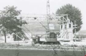
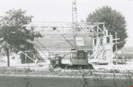
Douglas Road School gymnasium construction
https://search.heritageburnaby.ca/link/archivedescription38646
- Repository
- City of Burnaby Archives
- Date
- 1960
- Collection/Fonds
- Burnaby Historical Society fonds
- Description Level
- Item
- Physical Description
- 1 photograph : b&w ; 10 x 15 cm
- Scope and Content
- Photograph of a crew of workmen working on the construction of the new Douglas Road School gymnasium. None of the men are identified.
- Repository
- City of Burnaby Archives
- Date
- 1960
- Collection/Fonds
- Burnaby Historical Society fonds
- Subseries
- Douglas Road School subseries
- Physical Description
- 1 photograph : b&w ; 10 x 15 cm
- Description Level
- Item
- Record No.
- 471-007
- Access Restriction
- No restrictions
- Reproduction Restriction
- Reproduce for fair dealing purposes only
- Accession Number
- BHS2005-3
- Scope and Content
- Photograph of a crew of workmen working on the construction of the new Douglas Road School gymnasium. None of the men are identified.
- Names
- Douglas Road School
- Media Type
- Photograph
- Photographer
- Gordon, Ethel
- Notes
- Title based on contents of photograph.
- Geographic Access
- Canada Way
- Street Address
- 4861 Canada Way
- Historic Neighbourhood
- Burnaby Lake (Historic Neighbourhood)
- Planning Study Area
- Douglas-Gilpin Area
Images
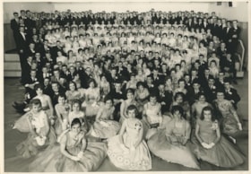
Graduates of Burnaby Central High
https://search.heritageburnaby.ca/link/archivedescription55587
- Repository
- City of Burnaby Archives
- Date
- 1961
- Collection/Fonds
- John Shaw fonds
- Description Level
- Item
- Physical Description
- 1 photograph : b&w ; 18 x 25.5 cm
- Scope and Content
- Photograph of a large group of over 200 young men and women dressed in formal attire, posing in the gymnasium of the school for this graduation picture. All of the women appear to be in prom dresses and the men are wearing suits.
- Repository
- City of Burnaby Archives
- Date
- 1961
- Collection/Fonds
- John Shaw fonds
- Series
- Shaw family series
- Physical Description
- 1 photograph : b&w ; 18 x 25.5 cm
- Description Level
- Item
- Record No.
- 485-062
- Access Restriction
- No restrictions
- Reproduction Restriction
- Reproduce for fair dealing purposes only
- Accession Number
- 2005-15
- 2006-01
- 2007-18
- Scope and Content
- Photograph of a large group of over 200 young men and women dressed in formal attire, posing in the gymnasium of the school for this graduation picture. All of the women appear to be in prom dresses and the men are wearing suits.
- Subjects
- Ceremonies - Graduations
- Media Type
- Photograph
- Photographer
- Cobbett, Bob
- Notes
- Title based on contents of photograph
- Photographer's stamp on verso
- Note on verso reads: "Graduation June, 1961 / Burnaby Central High"
- Geographic Access
- Canada Way
- Street Address
- 4939 Canada Way
- Historic Neighbourhood
- Burnaby Lake (Historic Neighbourhood)
- Planning Study Area
- Douglas-Gilpin Area
Images

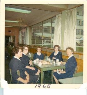
Nurses on coffee break
https://search.heritageburnaby.ca/link/archivedescription65514
- Repository
- City of Burnaby Archives
- Date
- 1965
- Collection/Fonds
- Victorian Order of Nurses fonds
- Description Level
- Item
- Physical Description
- 1 photograph : col. ; 8 x 8 cm
- Scope and Content
- Photograph of five Victorian Order of Nurses (VON) nurses having coffee break together at the Municipal Hall in Burnaby. The nurses are; (from left) Sue Cornelisse, Margaret Standerwick, Nettie Klokeid, Betty-Lou Sundquist and Marguerite Dobson.
- Repository
- City of Burnaby Archives
- Date
- 1965
- Collection/Fonds
- Victorian Order of Nurses fonds
- Physical Description
- 1 photograph : col. ; 8 x 8 cm
- Description Level
- Item
- Record No.
- 153-052
- Access Restriction
- No restrictions
- Reproduction Restriction
- Reproduce for fair dealing purposes only
- Accession Number
- 2010-09
- Scope and Content
- Photograph of five Victorian Order of Nurses (VON) nurses having coffee break together at the Municipal Hall in Burnaby. The nurses are; (from left) Sue Cornelisse, Margaret Standerwick, Nettie Klokeid, Betty-Lou Sundquist and Marguerite Dobson.
- Subjects
- Occupations - Nurses
- Names
- Victorian Order of Nurses
- Cornelisse, Sue
- Standerwick, Margaret
- Klokeid, Nettie
- Sundquist, Betty-Lou
- Dobson, Marguerite
- Media Type
- Photograph
- Notes
- Title based on contents of photograph
- Note on verso of photograph reads: “Coffee break in Municipal Hall / Cafeteria / L. to Right / Sue Cornelisse / Margaret Standerwick / Nettie Klokied [sic] / Betty-Lou Sundquist / Marguerite Dobson"
- Note on recto of photograph reads: “1965”
- Geographic Access
- Canada Way
- Street Address
- 4949 Canada Way
- Historic Neighbourhood
- Burnaby Lake (Historic Neighbourhood)
- Planning Study Area
- Douglas-Gilpin Area
Images

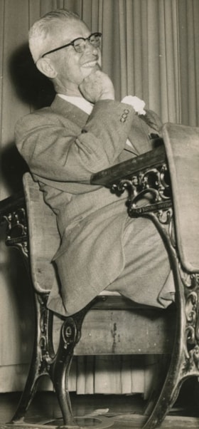
School Principal Burwell Brown
https://search.heritageburnaby.ca/link/archivedescription45177
- Repository
- City of Burnaby Archives
- Date
- 1960, published June 4, 1960
- Collection/Fonds
- Columbian Newspaper collection
- Description Level
- Item
- Physical Description
- 1 photograph : b&w ; 20 x 9.5 cm
- Scope and Content
- Photograph of Burwell Brown, Cascade Heights Elementary School Principal, taken the night of his retirement party at Burnaby Central High School. He is sitting in the "prisoner's box" at a mock trial that found him guilty of being an outstanding principal and teacher in Burnaby. He was the principa…
- Repository
- City of Burnaby Archives
- Date
- 1960, published June 4, 1960
- Collection/Fonds
- Columbian Newspaper collection
- Physical Description
- 1 photograph : b&w ; 20 x 9.5 cm
- Description Level
- Item
- Record No.
- 480-073
- Access Restriction
- No restrictions
- Reproduction Restriction
- Reproduce for fair dealing purposes only
- Accession Number
- 2003-02
- Scope and Content
- Photograph of Burwell Brown, Cascade Heights Elementary School Principal, taken the night of his retirement party at Burnaby Central High School. He is sitting in the "prisoner's box" at a mock trial that found him guilty of being an outstanding principal and teacher in Burnaby. He was the principal of Schou Street School from 1927 to 1953, before taking the same position at Cascade Heights Elementary School.
- Names
- Brown, Burwell
- Burnaby Central Secondary School
- Schou Street School
- Cascade Heights Elementary School
- Media Type
- Photograph
- Notes
- Title based on contents of photograph
- Geographic Access
- Canada Way
- Street Address
- 4939 Canada Way
- Historic Neighbourhood
- Burnaby Lake (Historic Neighbourhood)
- Planning Study Area
- Douglas-Gilpin Area
Images
