Narrow Results By
Subject
- Advertising Medium - Signs and Signboards 1
- Aerial Photographs 2
- Animals - Dogs 3
- Buildings 1
- Buildings - Civic 1
- Buildings - Civic - Fire Halls 1
- Buildings - Commercial 2
- Buildings - Commercial - Drive-In Theatres 1
- Buildings - Commercial - Hotels and Motels 2
- Buildings - Commercial - Malls 1
- Buildings - Commercial - Restaurants 1
- Buildings - Commercial - Stores 1

Interview with Sev Morin by Rod Fowler April 4, 1990 - Track 2
https://search.heritageburnaby.ca/link/oralhistory538
- Repository
- City of Burnaby Archives
- Date Range
- 1950-1990
- Length
- 00:06:16
- Summary
- This portion of the interview is about Sev Morin’s description of Burnaby’s growth and business development along Kingsway and Hastings, the Lake City Industrial Park, and the purchase of property in 1958 for the Heritage Park and Art Gallery.
- Repository
- City of Burnaby Archives
- Summary
- This portion of the interview is about Sev Morin’s description of Burnaby’s growth and business development along Kingsway and Hastings, the Lake City Industrial Park, and the purchase of property in 1958 for the Heritage Park and Art Gallery.
- Date Range
- 1950-1990
- Photo Info
- Sev Morin (left) of Severin's in Burnaby (formerly the Gai Paree) hosting a gala New Year's celebration, 1979. Item no. 480-712
- Length
- 00:06:16
- Subjects
- Buildings - Commercial
- Buildings - Civic
- Buildings - Industrial
- Buildings - Schools - Universities and Colleges
- Historic Neighbourhood
- Central Park (Historic Neighbourhood)
- Burnaby Lake (Historic Neighbourhood)
- Vancouver Heights (Historic Neighbourhood)
- Edmonds (Historic Neighbourhood)
- Planning Study Area
- Burnaby Heights Area
- Lake City Area
- Burnaby Mountain Area
- Kingsway-Beresford Area
- Douglas-Gilpin Area
- Interviewer
- Fowler, Rod
- Interview Date
- April 4, 1990
- Scope and Content
- Recording is of an interview with Severin "Sev" Morin, conducted by Rod Fowler. Sev Morin was one of eleven participants interviewed as part of the SFU/Burnaby Centennial Committee's oral history series titled, "Voices of Burnaby". The interview is mainly about Sev Morin’s banquet hall, restaurant and night club business on Kingsway, originally named the “Gai Paree Supper Club” (1947-1976) and later “Severin’s” (1976-1985) and “Diego’s” (1985-1994), its function as a Burnaby landmark, and the entertainment and political people he met through his business. He also describes his many volunteer activities in Burnaby, including member of the SFU Senate, Rotary Club, Variety Club and Telethon, fund raising for Burnaby Hospital, and tourism related groups, and his political work for the federal Liberal party. He talks about his parents’ origins, the lives of his brothers Rudy and Rene, and the family’s involvement in establishing the “Gai Paree”. He also shares his views about the business and cultural development of Burnaby. To view “Narrow By” terms for each track expand this description and see “Notes”.
- Biographical Notes
- Severin “Sev” Rene Morin was born September 21, 1927, in Bonneville, Alberta, to Rene Pierre Morin (1878-1963) and Anne Marie (nee Lachiver) Morin (1886-1956). Mr. and Mrs. R. P. Morin and their son Rene Francois (1905-1954) immigrated to Edmonton, Alberta, from France in 1913, where Rene Pierre Morin worked for the C.N.R. and a second son Adolphe “Rudy” Ferdinand (1922-1969) was born, followed by their third son Severin. In 1943, after R.P. Morin retired, the family moved to Burnaby to a house on Sperling Avenue. Sometime earlier the two older Morin brothers found work in Trail at the smelter and developed musical careers. In 1946/47 the Morin family purchased property on Kingsway and built a banquet hall, the “Gai Paree Supper Club”. Sev and Rudy Morin managed the club and Rene F. Morin moved to Burnaby to join them with his band. The supper club, with its live music and dance floor, became a popular meeting place and wedding venue, eventually expanding into a restaurant and nightclub in the 1970s. The “Gai Paree” was renamed “Severin’s” in 1976 and “Diego’s” in 1985, closing finally in 1994. Sev Morin’s business life included three record stores which he owned with his friend Jack Cullen. Through these businesses Sev Morin was well known in the entertainment and hospitality industry. He and his restaurant also hosted political and social events that made the restaurant a community landmark. Sev Morin contributed many volunteer hours to community and charitable organizations, including an appointment to the SFU Senate, fundraising for the Burnaby Hospital, Director of the Variety Club and Rotary Club, and consultant for a variety of tourism related ventures. He also was active in the federal Liberal Party. Sev Morin and his wife Pauline married in 1950 and had three children. Sev Morin died at age 86 on March 28, 2014.
- Total Tracks
- 10
- Total Length
- 00:56:44
- Interviewee Name
- Morin, Severin "Sev"
- Interviewer Bio
- Rod Fowler returned to university as a mature student in the 1980s after working about twenty years in the field of economics and computerization in business in England, Europe and Western Canada. He graduated with a BA from SFU in both History and Sociology in 1987, his MA degree in Geography in 1989, and his PhD in Cultural Geography at SFU. He taught courses in Geography, Sociology, History and Canadian Studies at several Lower Mainland colleges, before becoming a full time member of the Geography Department at Kwantlen University College.
- Collection/Fonds
- SFU/Burnaby Centennial Committee fonds
- Transcript Available
- Transcript available
- Media Type
- Sound Recording
- Web Notes
- Interviews were digitized in 2015 allowing them to be accessible on Heritage Burnaby. The digitization project was initiated by the Community Heritage Commission with support from City of Burnaby Council.
Images

Audio Tracks
Track two of interview with Sev Morin
Track two of interview with Sev Morin
https://search.heritageburnaby.ca/media/hpo/_Data/_Archives_Oral_Histories/_Unrestricted/MSS187-021/MSS187-021_Track%202.mp3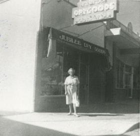
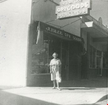
Jubilee Dry Goods Store
https://search.heritageburnaby.ca/link/archivedescription35767
- Repository
- City of Burnaby Archives
- Date
- 1965 (date of original), copied 1986
- Collection/Fonds
- Burnaby Historical Society fonds
- Description Level
- Item
- Physical Description
- 1 photograph : b&w ; 12.7 x 17.8 cm print
- Scope and Content
- Photograph of Gwen Pitman, store manager, in front of Jubilee Dry Goods. The store was founded by Ernest Pitman, her father, and closed in 1971. It was located at 6730 Jubilee Avenue, later the site of Bonsor Park.
- Repository
- City of Burnaby Archives
- Date
- 1965 (date of original), copied 1986
- Collection/Fonds
- Burnaby Historical Society fonds
- Subseries
- Pioneer Tales subseries
- Physical Description
- 1 photograph : b&w ; 12.7 x 17.8 cm print
- Description Level
- Item
- Record No.
- 204-625
- Access Restriction
- No restrictions
- Reproduction Restriction
- Reproduce for fair dealing purposes only
- Accession Number
- BHS1988-03
- Scope and Content
- Photograph of Gwen Pitman, store manager, in front of Jubilee Dry Goods. The store was founded by Ernest Pitman, her father, and closed in 1971. It was located at 6730 Jubilee Avenue, later the site of Bonsor Park.
- Subjects
- Buildings - Commercial - Stores
- Media Type
- Photograph
- Notes
- Title based on contents of photograph
- Geographic Access
- Jubilee Avenue
- Street Address
- 6730 Jubilee Avenue
- Historic Neighbourhood
- Central Park (Historic Neighbourhood)
- Planning Study Area
- Marlborough Area
Images
![Kingsway and Central Park, [196-] thumbnail](/media/hpo/_Data/_Archives_Images/_Unrestricted/001/083-001.jpg?width=280)
Kingsway and Central Park
https://search.heritageburnaby.ca/link/archivedescription34658
- Repository
- City of Burnaby Archives
- Date
- [196-]
- Collection/Fonds
- Burnaby Historical Society fonds
- Description Level
- Item
- Physical Description
- 1 photograph : b&w ; 14.5 x 19.4 cm
- Scope and Content
- Aerial photograph of Kingsway and Central Park.
- Repository
- City of Burnaby Archives
- Date
- [196-]
- Collection/Fonds
- Burnaby Historical Society fonds
- Subseries
- Photographs subseries
- Physical Description
- 1 photograph : b&w ; 14.5 x 19.4 cm
- Description Level
- Item
- Record No.
- 083-001
- Access Restriction
- No restrictions
- Reproduction Restriction
- Reproduce for fair dealing purposes only
- Accession Number
- BHS2007-04
- Scope and Content
- Aerial photograph of Kingsway and Central Park.
- Media Type
- Photograph
- Notes
- Title based on contents of photograph
- Geographic Access
- Kingsway
- Central Park
- Historic Neighbourhood
- Central Park (Historic Neighbourhood)
- Planning Study Area
- Maywood Area
Images
![Kingsway and Central Park, [196-] thumbnail](/media/hpo/_Data/_Archives_Images/_Unrestricted/001/083-001.jpg)
![LaFrance Class A Quintuplet, [after 1956] thumbnail](/media/hpo/_Data/_BVM_Images/2000/200200750003.jpg?width=280)
LaFrance Class A Quintuplet
https://search.heritageburnaby.ca/link/museumdescription1681
- Repository
- Burnaby Village Museum
- Date
- [after 1956]
- Collection/Fonds
- Burnaby Village Museum Photograph collection
- Description Level
- Item
- Physical Description
- 1 photograph: sepia photocopy ; 10 x 14 cm
- Scope and Content
- Photograph of Burnaby Fire Department's 1956 LaFrance Class A Quintuplet fire truck, considered "five fire trucks in one" because it served as a chemical truck (now a water tank), a hose truck, pumper truck, city service ladder truck and 100 ft aerial ladder truck. Truck no. 8 is parked in front of…
- Repository
- Burnaby Village Museum
- Collection/Fonds
- Burnaby Village Museum Photograph collection
- Description Level
- Item
- Physical Description
- 1 photograph: sepia photocopy ; 10 x 14 cm
- Scope and Content
- Photograph of Burnaby Fire Department's 1956 LaFrance Class A Quintuplet fire truck, considered "five fire trucks in one" because it served as a chemical truck (now a water tank), a hose truck, pumper truck, city service ladder truck and 100 ft aerial ladder truck. Truck no. 8 is parked in front of fire hall no. 3.
- Names
- Burnaby Fire Department
- Geographic Access
- Marlborough Avenue
- Street Address
- 6511 Marlborough Avenue
- Accession Code
- BV002.75.3
- Access Restriction
- Restricted access
- Reproduction Restriction
- May be restricted by third party rights
- Date
- [after 1956]
- Media Type
- Photograph
- Historic Neighbourhood
- Central Park (Historic Neighbourhood)
- Planning Study Area
- Marlborough Area
- Scan Resolution
- 600
- Scan Date
- 09-Jun-09
- Scale
- 100
- Notes
- Typed note on recto of photograph reads: "First in Canada 1956"
- Typed note on verso of photograph reads: "Five fire trucks in one. Chemical -- Now water trank Hose truck. Pumper truck. City service ladder truck. Aerial ladder truck 100 ft."
- Address sticker on verso of photograph reads: "Mr F. Blake 4165 Pandora Street Burnaby, B.C. Canada V5C 2B2"
Images
![LaFrance Class A Quintuplet, [after 1956] thumbnail](/media/hpo/_Data/_BVM_Images/2000/200200750003.jpg)
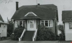
Matheson family home
https://search.heritageburnaby.ca/link/archivedescription37667
- Repository
- City of Burnaby Archives
- Date
- 1962 (date of original), copied 1991
- Collection/Fonds
- Burnaby Historical Society fonds
- Description Level
- Item
- Physical Description
- 1 photograph : b&w ; 3.3 x 5.4 cm print on contact sheet 20.2 x 25.3 cm
- Scope and Content
- Photograph of the Matheson family home at 6149 McKay Avenue (formerly numbered 2890 McKay Avenue). It was built in the spring of 1926.
- Repository
- City of Burnaby Archives
- Date
- 1962 (date of original), copied 1991
- Collection/Fonds
- Burnaby Historical Society fonds
- Subseries
- Burnaby Image Bank subseries
- Physical Description
- 1 photograph : b&w ; 3.3 x 5.4 cm print on contact sheet 20.2 x 25.3 cm
- Description Level
- Item
- Record No.
- 370-255
- Access Restriction
- No restrictions
- Reproduction Restriction
- No restrictions
- Accession Number
- BHS1999-03
- Scope and Content
- Photograph of the Matheson family home at 6149 McKay Avenue (formerly numbered 2890 McKay Avenue). It was built in the spring of 1926.
- Subjects
- Buildings - Residential - Houses
- Media Type
- Photograph
- Notes
- Title based on contents of photograph
- 1 b&w copy negative accompanying
- Negative has a pink cast
- Geographic Access
- McKay Avenue
- Street Address
- 6149 McKay Avenue
- Historic Neighbourhood
- Central Park (Historic Neighbourhood)
- Planning Study Area
- Maywood Area
Images

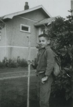
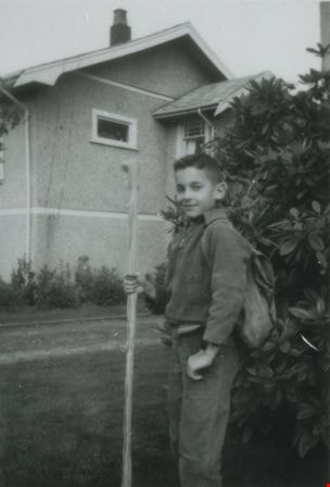
Michael Loynes
https://search.heritageburnaby.ca/link/archivedescription37664
- Repository
- City of Burnaby Archives
- Date
- 1963 (date of original), copied 1991
- Collection/Fonds
- Burnaby Historical Society fonds
- Description Level
- Item
- Physical Description
- 1 photograph : b&w ; 4.1 x 2.8 cm print on contact sheet 20.2 x 25.3 cm
- Scope and Content
- Photograph of Michael Loynes with a large walking stick in the front yard 6131 Silver Avenue. The Coutts family home can be seen in the background.
- Repository
- City of Burnaby Archives
- Date
- 1963 (date of original), copied 1991
- Collection/Fonds
- Burnaby Historical Society fonds
- Subseries
- Burnaby Image Bank subseries
- Physical Description
- 1 photograph : b&w ; 4.1 x 2.8 cm print on contact sheet 20.2 x 25.3 cm
- Description Level
- Item
- Record No.
- 370-252
- Access Restriction
- No restrictions
- Reproduction Restriction
- No restrictions
- Accession Number
- BHS1999-03
- Scope and Content
- Photograph of Michael Loynes with a large walking stick in the front yard 6131 Silver Avenue. The Coutts family home can be seen in the background.
- Subjects
- Recreational Activities - Hiking
- Names
- Loynes, Michael "Mike"
- Media Type
- Photograph
- Notes
- Title based on contents of photograph
- 1 b&w copy negative accompanying
- Negative has a pink cast
- Geographic Access
- Silver Avenue
- Street Address
- 6131 Silver Avenue
- Historic Neighbourhood
- Central Park (Historic Neighbourhood)
- Planning Study Area
- Maywood Area
Images
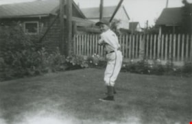
Michael Loynes in Baseball Uniform
https://search.heritageburnaby.ca/link/archivedescription37666
- Repository
- City of Burnaby Archives
- Date
- 1964 (date of original), copied 1991
- Collection/Fonds
- Burnaby Historical Society fonds
- Description Level
- Item
- Physical Description
- 1 photograph : b&w ; 3.3 x 5.0 cm print on contact sheet 20.2 x 25.3 cm
- Scope and Content
- Photograph of Michael Loynes in a baseball uniform and holding a bat at the back of 6131 Silver Avenue in the summer of 1964.
- Repository
- City of Burnaby Archives
- Date
- 1964 (date of original), copied 1991
- Collection/Fonds
- Burnaby Historical Society fonds
- Subseries
- Burnaby Image Bank subseries
- Physical Description
- 1 photograph : b&w ; 3.3 x 5.0 cm print on contact sheet 20.2 x 25.3 cm
- Description Level
- Item
- Record No.
- 370-254
- Access Restriction
- No restrictions
- Reproduction Restriction
- No restrictions
- Accession Number
- BHS1999-03
- Scope and Content
- Photograph of Michael Loynes in a baseball uniform and holding a bat at the back of 6131 Silver Avenue in the summer of 1964.
- Subjects
- Sports - Baseball
- Sports - Team Sports
- Names
- Loynes, Michael "Mike"
- Media Type
- Photograph
- Notes
- Title based on contents of photograph
- 1 b&w copy negative accompanying
- Negative has a pink cast
- Geographic Access
- Silver Avenue
- Street Address
- 6131 Silver Avenue
- Historic Neighbourhood
- Central Park (Historic Neighbourhood)
- Planning Study Area
- Maywood Area
Images

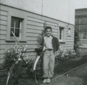
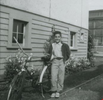
Michael Loynes with his bicycle
https://search.heritageburnaby.ca/link/archivedescription37665
- Repository
- City of Burnaby Archives
- Date
- Jul. 1963 (date of original), copied 1991
- Collection/Fonds
- Burnaby Historical Society fonds
- Description Level
- Item
- Physical Description
- 1 photograph : b&w ; 3.9 x 4.0 cm print on contact sheet 20.2 x 25.3 cm
- Scope and Content
- Photograph of Michael Loynes standing beside a bicycle at the side of 6131 Silver Avenue. The Ford Motor plant is visible in the background.
- Repository
- City of Burnaby Archives
- Date
- Jul. 1963 (date of original), copied 1991
- Collection/Fonds
- Burnaby Historical Society fonds
- Subseries
- Burnaby Image Bank subseries
- Physical Description
- 1 photograph : b&w ; 3.9 x 4.0 cm print on contact sheet 20.2 x 25.3 cm
- Description Level
- Item
- Record No.
- 370-253
- Access Restriction
- No restrictions
- Reproduction Restriction
- No restrictions
- Accession Number
- BHS1999-03
- Scope and Content
- Photograph of Michael Loynes standing beside a bicycle at the side of 6131 Silver Avenue. The Ford Motor plant is visible in the background.
- Subjects
- Transportation - Bicycles
- Media Type
- Photograph
- Notes
- Title based on contents of photograph
- 1 b&w copy negative accompanying
- Negative has a pink cast
- Geographic Access
- Silver Avenue
- Street Address
- 6131 Silver Avenue
- Historic Neighbourhood
- Central Park (Historic Neighbourhood)
- Planning Study Area
- Maywood Area
Images
![Mike and Dennis Krewenchuk, [between 1958 and 196-] thumbnail](/media/hpo/_Data/_Archives_Images/_Unrestricted/580/582-002.jpg?width=280)
Mike and Dennis Krewenchuk
https://search.heritageburnaby.ca/link/archivedescription88413
- Repository
- City of Burnaby Archives
- Date
- [between 1958 and 196-]
- Collection/Fonds
- Krewenchuk family fonds
- Description Level
- Item
- Physical Description
- 1 photograph : b&w ; 9 x 13 cm
- Scope and Content
- Photograph of Mike (father) and Dennis (son) Krewenchuk seated on the flower bed of the Nelson Motel (also known as the Nelson Auto Court and Nelson Bungalow Court). The stairs to the motel office can be seen to the left with the wall of the building in behind them. The building served as the Krewe…
- Repository
- City of Burnaby Archives
- Date
- [between 1958 and 196-]
- Collection/Fonds
- Krewenchuk family fonds
- Physical Description
- 1 photograph : b&w ; 9 x 13 cm
- Description Level
- Item
- Record No.
- 582-002
- Access Restriction
- No restrictions
- Reproduction Restriction
- No restrictions
- Accession Number
- 2015-05
- Scope and Content
- Photograph of Mike (father) and Dennis (son) Krewenchuk seated on the flower bed of the Nelson Motel (also known as the Nelson Auto Court and Nelson Bungalow Court). The stairs to the motel office can be seen to the left with the wall of the building in behind them. The building served as the Krewenchuk family home and business office and was located at 6550 Nelson Avenue. Michael and his wife Mary owned the business and property between 1957 and 1967, while raising their son Dennis.
- Media Type
- Photograph
- Notes
- Title based on contents of photograph
- Street Address
- 6550 Nelson Avenue
- Historic Neighbourhood
- Central Park (Historic Neighbourhood)
- Planning Study Area
- Windsor Area
Images
![Mike and Dennis Krewenchuk, [between 1958 and 196-] thumbnail](/media/hpo/_Data/_Archives_Images/_Unrestricted/580/582-002.jpg)
![Nelson Bungalow Court, [between 1958 and 196-] thumbnail](/media/hpo/_Data/_Archives_Images/_Unrestricted/580/582-001.jpg?width=280)
Nelson Bungalow Court
https://search.heritageburnaby.ca/link/archivedescription88412
- Repository
- City of Burnaby Archives
- Date
- [between 1958 and 196-]
- Collection/Fonds
- Krewenchuk family fonds
- Description Level
- Item
- Physical Description
- 1 photograph : b&w ; 8 x 11.5 cm
- Scope and Content
- Photograph of the Nelson Bungalow Court (also known as The Nelson Motel and The Nelson Auto Court) located at 6550 Nelson Avenue. The motel was owned and operated by Michael and Mary Krewenchuk between 1957 to 1967. The building in the photo was the family home and office for the motel on one acre …
- Repository
- City of Burnaby Archives
- Date
- [between 1958 and 196-]
- Collection/Fonds
- Krewenchuk family fonds
- Physical Description
- 1 photograph : b&w ; 8 x 11.5 cm
- Description Level
- Item
- Record No.
- 582-001
- Access Restriction
- No restrictions
- Reproduction Restriction
- No restrictions
- Accession Number
- 2015-05
- Scope and Content
- Photograph of the Nelson Bungalow Court (also known as The Nelson Motel and The Nelson Auto Court) located at 6550 Nelson Avenue. The motel was owned and operated by Michael and Mary Krewenchuk between 1957 to 1967. The building in the photo was the family home and office for the motel on one acre of land with eight cabins and seven trailors for lease. Lobely Park was located behind the house on adjacent property. The house is surrounded by trees including a monkey puzzle tree standing in front near a lampost with a totem pole design.
- Media Type
- Photograph
- Notes
- Title based on contents of photograph
- Street Address
- 6550 Nelson Avenue
- Historic Neighbourhood
- Central Park (Historic Neighbourhood)
- Planning Study Area
- Windsor Area
Images
![Nelson Bungalow Court, [between 1958 and 196-] thumbnail](/media/hpo/_Data/_Archives_Images/_Unrestricted/580/582-001.jpg)
![Orchard Shopping Centre, [196-] thumbnail](/media/hpo/_Data/_Archives_Images/_Unrestricted/001/069-002.jpg?width=280)
Orchard Shopping Centre
https://search.heritageburnaby.ca/link/archivedescription34634
- Repository
- City of Burnaby Archives
- Date
- [196-]
- Collection/Fonds
- Burnaby Historical Society fonds
- Description Level
- Item
- Physical Description
- 1 photograph : b&w ; 12.6 x 20.4 cm
- Scope and Content
- Aerial photograph of the Old Orchard Shopping Centre on Kingsway.
- Repository
- City of Burnaby Archives
- Date
- [196-]
- Collection/Fonds
- Burnaby Historical Society fonds
- Subseries
- Photographs subseries
- Physical Description
- 1 photograph : b&w ; 12.6 x 20.4 cm
- Description Level
- Item
- Record No.
- 069-002
- Access Restriction
- No restrictions
- Reproduction Restriction
- Reproduce for fair dealing purposes only
- Accession Number
- BHS2007-04
- Scope and Content
- Aerial photograph of the Old Orchard Shopping Centre on Kingsway.
- Media Type
- Photograph
- Notes
- Title based on contents of photograph
- Geographic Access
- Kingsway
- Street Address
- 4469 Kingsway
- Historic Neighbourhood
- Central Park (Historic Neighbourhood)
- Planning Study Area
- Maywood Area
Images
![Orchard Shopping Centre, [196-] thumbnail](/media/hpo/_Data/_Archives_Images/_Unrestricted/001/069-002.jpg)
Packard and Nelson Auto Court
https://search.heritageburnaby.ca/link/archivedescription88416
- Repository
- City of Burnaby Archives
- Date
- 1964
- Collection/Fonds
- Krewenchuk family fonds
- Description Level
- Item
- Physical Description
- 1 photograph : b&w ; 9 x 9 cm
- Scope and Content
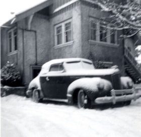
- Photograph of Dennis Krewenchuk's snow covered 1941 Packard automobile parked in the snowy driveway outside his parent's home and business, The Nelson Auto Court (also known as the Nelson Motel and Nelson Bungalow Court).
- Repository
- City of Burnaby Archives
- Date
- 1964
- Collection/Fonds
- Krewenchuk family fonds
- Physical Description
- 1 photograph : b&w ; 9 x 9 cm
- Description Level
- Item
- Record No.
- 582-005
- Access Restriction
- No restrictions
- Reproduction Restriction
- No restrictions
- Accession Number
- 2015-05
- Scope and Content
- Photograph of Dennis Krewenchuk's snow covered 1941 Packard automobile parked in the snowy driveway outside his parent's home and business, The Nelson Auto Court (also known as the Nelson Motel and Nelson Bungalow Court).
- Media Type
- Photograph
- Notes
- Title based on contents of photograph
- Date on border of photograph reads: "64"
- Geographic Access
- Dunblane Avenue
- Marlborough Avenue
- Historic Neighbourhood
- Central Park (Historic Neighbourhood)
- Planning Study Area
- Windsor Area
Images

Packard automobile
https://search.heritageburnaby.ca/link/archivedescription88414
- Repository
- City of Burnaby Archives
- Date
- 1962
- Collection/Fonds
- Krewenchuk family fonds
- Description Level
- Item
- Physical Description
- 1 photograph : b&w ; 7.5 x 10.5 cm
- Scope and Content
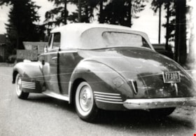
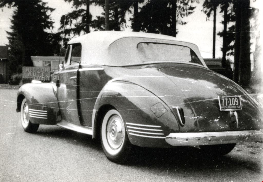
- Photograph of a 1941 Packard automobile owned by Dennis Krewenchuk from 1961 to 1964. The car is parked on the road outside Lobely Park on Dunblane Avenue. The Nelson Auto Court sign can be seen in the background. Dennis Krewenchuk's parents owned the Auto Court from 1957 to 1967 and Dennis lived t…
- Repository
- City of Burnaby Archives
- Date
- 1962
- Collection/Fonds
- Krewenchuk family fonds
- Physical Description
- 1 photograph : b&w ; 7.5 x 10.5 cm
- Description Level
- Item
- Record No.
- 582-003
- Access Restriction
- No restrictions
- Reproduction Restriction
- No restrictions
- Accession Number
- 2015-05
- Scope and Content
- Photograph of a 1941 Packard automobile owned by Dennis Krewenchuk from 1961 to 1964. The car is parked on the road outside Lobely Park on Dunblane Avenue. The Nelson Auto Court sign can be seen in the background. Dennis Krewenchuk's parents owned the Auto Court from 1957 to 1967 and Dennis lived there while atteding highschool.
- Subjects
- Transportation - Automobiles
- Media Type
- Photograph
- Notes
- Title based on contents of photograph
- Note on verso of photograph reads: "62"
- Geographic Access
- Dunblane Avenue
- Historic Neighbourhood
- Central Park (Historic Neighbourhood)
- Planning Study Area
- Windsor Area
Images
Packard automobile
https://search.heritageburnaby.ca/link/archivedescription88415
- Repository
- City of Burnaby Archives
- Date
- 1962
- Collection/Fonds
- Krewenchuk family fonds
- Description Level
- Item
- Physical Description
- 1 photograph : b&w ; 7.5 x 10.5 cm
- Scope and Content
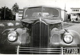
- Photograph of the front of a 1941 Packard automobile owned by Dennis Krewenchuk from 1961 to 1964. The car is parked on the road outside Lobely Park on Dunblane Avenue with buildings on Marlborough Street in the background.
- Repository
- City of Burnaby Archives
- Date
- 1962
- Collection/Fonds
- Krewenchuk family fonds
- Physical Description
- 1 photograph : b&w ; 7.5 x 10.5 cm
- Description Level
- Item
- Record No.
- 582-004
- Access Restriction
- No restrictions
- Reproduction Restriction
- No restrictions
- Accession Number
- 2015-05
- Scope and Content
- Photograph of the front of a 1941 Packard automobile owned by Dennis Krewenchuk from 1961 to 1964. The car is parked on the road outside Lobely Park on Dunblane Avenue with buildings on Marlborough Street in the background.
- Subjects
- Transportation - Automobiles
- Media Type
- Photograph
- Notes
- Title based on contents of photograph
- Note on verso of photograph reads: "62"
- Geographic Access
- Dunblane Avenue
- Marlborough Avenue
- Historic Neighbourhood
- Central Park (Historic Neighbourhood)
- Planning Study Area
- Windsor Area
Images

![Philips family in dining room at Christmas, [Jan. 1962] thumbnail](/media/hpo/_Data/_BVM_Images/2022/2022_0011_0002_001.jpg?width=280)
Philips family in dining room at Christmas
https://search.heritageburnaby.ca/link/museumdescription19083
- Repository
- Burnaby Village Museum
- Date
- [Jan. 1962]
- Collection/Fonds
- Earl and Adell Philips family fonds
- Description Level
- Item
- Physical Description
- 1 photograph : b&w ; 9 x 9 cm
- Scope and Content
- Photograph of the Philips family seated around a table in their dining room of their house located at 5877 Barker Avenue, Burnaby. People are identified from left to right: Shannon McKeemen and Ann McKeemen, Bob Paterson, Earl Philips, Adell Philips, Lorayne Philips, Cory Philips, Lea Philips, Ju…
- Repository
- Burnaby Village Museum
- Collection/Fonds
- Earl and Adell Philips family fonds
- Description Level
- Item
- Physical Description
- 1 photograph : b&w ; 9 x 9 cm
- Scope and Content
- Photograph of the Philips family seated around a table in their dining room of their house located at 5877 Barker Avenue, Burnaby. People are identified from left to right: Shannon McKeemen and Ann McKeemen, Bob Paterson, Earl Philips, Adell Philips, Lorayne Philips, Cory Philips, Lea Philips, Judith Philips. Photograph was taken during Christmas, everyone is wearing a tissue paper hat and the table cloth has a pointsettia design.
- Names
- Philips, Adell Greenwood
- Philips, Judith
- Philips, Lea
- Philips, Lorayne
- Philips, Earl Gene
- Philips, Cory
- McKeeman, Ann
- McKeeman, Shannon
- Paterson, Bob
- Geographic Access
- Barker Avenue
- Street Address
- 5877 Barker Avenue
- Accession Code
- BV022.11.2
- Access Restriction
- No restrictions
- Reproduction Restriction
- No known restrictions
- Date
- [Jan. 1962]
- Media Type
- Photograph
- Historic Neighbourhood
- Central Park (Historic Neighbourhood)
- Notes
- Title based on contents of photograph
- Stamp along right edge of photo includes print date which reads: "JAN. 62"
- Note in pencil on verso of photograph reads: "Barker Ave. / Christmas 1961"
Images
![Philips family in dining room at Christmas, [Jan. 1962] thumbnail](/media/hpo/_Data/_BVM_Images/2022/2022_0011_0002_001.jpg)
![Sambo's Pancake House, [196-] thumbnail](/media/hpo/_Data/_Archives_Images/_Unrestricted/126/201-001.jpg?width=280)
Sambo's Pancake House
https://search.heritageburnaby.ca/link/archivedescription35138
- Repository
- City of Burnaby Archives
- Date
- [196-]
- Collection/Fonds
- Burnaby Historical Society fonds
- Description Level
- Item
- Physical Description
- 1 photograph : col. postcard ; 8.9 x 14.0 cm
- Scope and Content
- Photographic postcard of the exterior and parking lot of Sambo's Pancake House, Kingsway. Printed on the top of the front of the postcard is "Sambo's Pancake House," and a sign on the building read's "Sambo's." Written on the back of the postcard: "Please surrender this card for 10% discount on you…
- Repository
- City of Burnaby Archives
- Date
- [196-]
- Collection/Fonds
- Burnaby Historical Society fonds
- Subseries
- Photographs subseries
- Physical Description
- 1 photograph : col. postcard ; 8.9 x 14.0 cm
- Description Level
- Item
- Record No.
- 201-001
- Access Restriction
- No restrictions
- Reproduction Restriction
- Reproduce for fair dealing purposes only
- Accession Number
- BHS1987-10
- Scope and Content
- Photographic postcard of the exterior and parking lot of Sambo's Pancake House, Kingsway. Printed on the top of the front of the postcard is "Sambo's Pancake House," and a sign on the building read's "Sambo's." Written on the back of the postcard: "Please surrender this card for 10% discount on your next visit to Sambo's, 5550 Kingsway, Burnaby. Offer good until Feb. 28th, 1969. Your host Sambo's."
- Subjects
- Geographic Features - Automobile Parking Lots
- Documentary Artifacts - Postcards
- Buildings - Commercial - Restaurants
- Names
- Sambo's Pancake House
- Media Type
- Photograph
- Notes
- Title based on contents of photograph
- Geographic Access
- Kingsway
- Street Address
- 5550 Kingsway
- Historic Neighbourhood
- Central Park (Historic Neighbourhood)
- Planning Study Area
- Windsor Area
Images
![Sambo's Pancake House, [196-] thumbnail](/media/hpo/_Data/_Archives_Images/_Unrestricted/126/201-001.jpg)
![Sanderson family home, [between 1950 and 1969] thumbnail](/media/hpo/_Data/_Archives_Images/_Unrestricted/513/521-022.jpg?width=280)
Sanderson family home
https://search.heritageburnaby.ca/link/archivedescription65790
- Repository
- City of Burnaby Archives
- Date
- [between 1950 and 1969]
- Collection/Fonds
- Field family fonds
- Description Level
- Item
- Physical Description
- 1 photograph (tiff) ; 600 ppi
- Scope and Content
- Photograph of the Sanderson family home (believed to be located at 3812/5457 Inman Avenue, one block north of Central Park). A larger house which still stands on this property replaced this house in 1921.
- Repository
- City of Burnaby Archives
- Date
- [between 1950 and 1969]
- Collection/Fonds
- Field family fonds
- Physical Description
- 1 photograph (tiff) ; 600 ppi
- Material Details
- Item is a scan of a b&w photograph
- Description Level
- Item
- Record No.
- 521-022
- Access Restriction
- No restrictions
- Reproduction Restriction
- Reproduce for fair dealing purposes only
- Accession Number
- 2010-14
- Scope and Content
- Photograph of the Sanderson family home (believed to be located at 3812/5457 Inman Avenue, one block north of Central Park). A larger house which still stands on this property replaced this house in 1921.
- Subjects
- Buildings - Residential - Houses
- Media Type
- Photograph
- Notes
- Title based on contents of photograph
- Geographic Access
- Inman Avenue
- Historic Neighbourhood
- Central Park (Historic Neighbourhood)
- Planning Study Area
- Maywood Area
Images
![Sanderson family home, [between 1950 and 1969] thumbnail](/media/hpo/_Data/_Archives_Images/_Unrestricted/513/521-022.jpg)
![Smith family home, [1960] (date of original), copied 1986 thumbnail](/media/hpo/_Data/_Archives_Images/_Unrestricted/204/204-310.jpg?width=280)
Smith family home
https://search.heritageburnaby.ca/link/archivedescription35452
- Repository
- City of Burnaby Archives
- Date
- [1960] (date of original), copied 1986
- Collection/Fonds
- Burnaby Historical Society fonds
- Description Level
- Item
- Physical Description
- 1 photograph : b&w ; 12.7 x 17.8 cm print
- Scope and Content
- Photograph of the Smith family home at 6186 Royal Oak Road. Although this photograph was taken in the 1960s, this was one of the first houses built on Royal Oak, in 1907. This was the home of James Smith and his wife, Agnes Smith (nee Taylor). They had four children: Grace Smith (later Grace Pletc…
- Repository
- City of Burnaby Archives
- Date
- [1960] (date of original), copied 1986
- Collection/Fonds
- Burnaby Historical Society fonds
- Subseries
- Pioneer Tales subseries
- Physical Description
- 1 photograph : b&w ; 12.7 x 17.8 cm print
- Description Level
- Item
- Record No.
- 204-310
- Access Restriction
- No restrictions
- Reproduction Restriction
- Reproduce for fair dealing purposes only
- Accession Number
- BHS1988-03
- Scope and Content
- Photograph of the Smith family home at 6186 Royal Oak Road. Although this photograph was taken in the 1960s, this was one of the first houses built on Royal Oak, in 1907. This was the home of James Smith and his wife, Agnes Smith (nee Taylor). They had four children: Grace Smith (later Grace Pletcher), Bob Smith, Warden Smith, and Ada Smith. It was a BC Mill Timber and Trading Co. prefabricated house originally built in BC and shipped to this site.
- Subjects
- Buildings - Residential - Houses
- Media Type
- Photograph
- Notes
- Title based on contents of photograph
- Geographic Access
- Royal Oak Avenue
- Street Address
- 6186 Royal Oak Avenue
- Historic Neighbourhood
- Central Park (Historic Neighbourhood)
- Planning Study Area
- Windsor Area
Images
![Smith family home, [1960] (date of original), copied 1986 thumbnail](/media/hpo/_Data/_Archives_Images/_Unrestricted/204/204-310.jpg)
![Violet Gibbs, [between 1963 and 1967] (date of original), copied 1991 thumbnail](/media/hpo/_Data/_Archives_Images/_Unrestricted/370/370-395.jpg?width=280)
Violet Gibbs
https://search.heritageburnaby.ca/link/archivedescription37807
- Repository
- City of Burnaby Archives
- Date
- [between 1963 and 1967] (date of original), copied 1991
- Collection/Fonds
- Burnaby Historical Society fonds
- Description Level
- Item
- Physical Description
- 1 photograph : b&w ; 4.3 x 2.9 cm print on contact sheet 20.7 x 26.7 cm
- Scope and Content
- Photograph of (left to right) the daughter of Violet Gibbs, Violet Gibbs with a vegetable from the garden in her hand and Clara MacDonald in the garden at the back of 3424 Olive Avenue (later renumbered 5827 Olive Avenue).
- Repository
- City of Burnaby Archives
- Date
- [between 1963 and 1967] (date of original), copied 1991
- Collection/Fonds
- Burnaby Historical Society fonds
- Subseries
- Burnaby Image Bank subseries
- Physical Description
- 1 photograph : b&w ; 4.3 x 2.9 cm print on contact sheet 20.7 x 26.7 cm
- Description Level
- Item
- Record No.
- 370-395
- Access Restriction
- No restrictions
- Reproduction Restriction
- No restrictions
- Accession Number
- BHS1999-03
- Scope and Content
- Photograph of (left to right) the daughter of Violet Gibbs, Violet Gibbs with a vegetable from the garden in her hand and Clara MacDonald in the garden at the back of 3424 Olive Avenue (later renumbered 5827 Olive Avenue).
- Subjects
- Geographic Features - Gardens
- Media Type
- Photograph
- Notes
- Title based on contents of photograph
- 1 b&w copy negative accompanying
- Negative has a pink cast
- Geographic Access
- Olive Avenue
- Street Address
- 5827 Olive Avenue
- Historic Neighbourhood
- Central Park (Historic Neighbourhood)
- Planning Study Area
- Maywood Area
Images
![Violet Gibbs, [between 1963 and 1967] (date of original), copied 1991 thumbnail](/media/hpo/_Data/_Archives_Images/_Unrestricted/370/370-395.jpg)