More like 'The Lions from Burnaby Park'
Narrow Results By
Subject
- Advertising Medium - Signs and Signboards 1
- Aerial Photographs 16
- Agricultural Tools and Equipment 1
- Agriculture - Farms 1
- Animals 1
- Animals - Birds 1
- Animals - Dogs 1
- Building Components 1
- Buildings - Commercial - Malls 1
- Buildings - Commercial - Restaurants 1
- Buildings - Commercial - Stores 1
- Buildings - Heritage 2
Aerial photograph of Burnaby Mountain and Port Moody
https://search.heritageburnaby.ca/link/archivedescription84885
- Repository
- City of Burnaby Archives
- Date
- 1963
- Collection/Fonds
- Allan Amundsen collection
- Description Level
- Item
- Physical Description
- 1 photograph : b&w ; 22.5 x 22.5 cm
- Scope and Content
- Aerial photograph of Burnaby Mountain to the west, Burrard Inlet to the north and Port Moody to the east.
- Repository
- City of Burnaby Archives
- Date
- 1963
- Collection/Fonds
- Allan Amundsen collection
- Physical Description
- 1 photograph : b&w ; 22.5 x 22.5 cm
- Description Level
- Item
- Record No.
- 561-006
- Access Restriction
- In Archives only
- Reproduction Restriction
- No reproduction permitted
- Accession Number
- 2014-08
- Scope and Content
- Aerial photograph of Burnaby Mountain to the west, Burrard Inlet to the north and Port Moody to the east.
- Media Type
- Photograph
- Photographer
- Province of British Columbia
- Notes
- Title based on contents of photograph
- This photo is indentified as BC5061:80 and connects with B.C. air photograph BC5061:81 to the west and BC5061:79 to the east.
- Geographic Access
- Burrard Inlet
- Burnaby Mountain Conservation Area
- Historic Neighbourhood
- Barnet (Historic Neighbourhood)
- Planning Study Area
- Burnaby Mountain Area
Aerial photograph of Burrard Inlet
https://search.heritageburnaby.ca/link/archivedescription84888
- Repository
- City of Burnaby Archives
- Date
- 1963
- Collection/Fonds
- Allan Amundsen collection
- Description Level
- Item
- Physical Description
- 1 photograph : b&w ; 22.5 x 22.5 cm
- Scope and Content
- Aerial photograph of Burrard Inlet and Port Moody.
- Repository
- City of Burnaby Archives
- Date
- 1963
- Collection/Fonds
- Allan Amundsen collection
- Physical Description
- 1 photograph : b&w ; 22.5 x 22.5 cm
- Description Level
- Item
- Record No.
- 561-009
- Access Restriction
- In Archives only
- Reproduction Restriction
- No reproduction permitted
- Accession Number
- 2014-08
- Scope and Content
- Aerial photograph of Burrard Inlet and Port Moody.
- Media Type
- Photograph
- Photographer
- Province of British Columbia
- Notes
- Title based on contents of photograph
- This photo is indentified as BC5061:77 and connects with B.C. air photograph BC5061:78 to the west and BC5061:76 to the east
- Geographic Access
- Burrard Inlet
Aerial photograph of Coquitlam
https://search.heritageburnaby.ca/link/archivedescription84890
- Repository
- City of Burnaby Archives
- Date
- 1963
- Collection/Fonds
- Allan Amundsen collection
- Description Level
- Item
- Physical Description
- 1 photograph : b&w ; 22.5 x 22.5 cm
- Scope and Content
- Aerial photograph of Coquitlam with Burrard Inlet on the western edge of the image.
- Repository
- City of Burnaby Archives
- Date
- 1963
- Collection/Fonds
- Allan Amundsen collection
- Physical Description
- 1 photograph : b&w ; 22.5 x 22.5 cm
- Description Level
- Item
- Record No.
- 561-011
- Access Restriction
- In Archives only
- Reproduction Restriction
- No reproduction permitted
- Accession Number
- 2014-08
- Scope and Content
- Aerial photograph of Coquitlam with Burrard Inlet on the western edge of the image.
- Media Type
- Photograph
- Photographer
- Province of British Columbia
- Notes
- Title based on contents of photograph
- This photo is identified as BC5061:75 and connects with B.C. air photograph BC5061:76 to the west
Aerial photograph of North Burnaby
https://search.heritageburnaby.ca/link/archivedescription84881
- Repository
- City of Burnaby Archives
- Date
- 1963
- Collection/Fonds
- Allan Amundsen collection
- Description Level
- Item
- Physical Description
- 1 photograph : b&w ; 22.5 x 22.5 cm
- Scope and Content
- Aerial photograph of North Burnaby with Burrard Inlet to the north and Hastings Street, Inlet Drive, Barnet Road.
- Repository
- City of Burnaby Archives
- Date
- 1963
- Collection/Fonds
- Allan Amundsen collection
- Physical Description
- 1 photograph : b&w ; 22.5 x 22.5 cm
- Description Level
- Item
- Record No.
- 561-002
- Access Restriction
- In Archives only
- Reproduction Restriction
- No reproduction permitted
- Accession Number
- 2014-08
- Scope and Content
- Aerial photograph of North Burnaby with Burrard Inlet to the north and Hastings Street, Inlet Drive, Barnet Road.
- Media Type
- Photograph
- Photographer
- Province of British Columbia
- Notes
- Title based on contents of photograph
- This photo is indentified as BC5061:84 and connects with B.C. air photograph BC5061:85 to the west and BC5061:83 to the east
- Geographic Access
- Burrard Inlet
- Burnaby Mountain Conservation Area
- Historic Neighbourhood
- Capitol Hill (Historic Neighbourhood)
- Lochdale (Historic Neighbourhood)
- Planning Study Area
- Parkcrest-Aubrey Area
- Westridge Area
Aerial photograph of North Burnaby
https://search.heritageburnaby.ca/link/archivedescription93598
- Repository
- City of Burnaby Archives
- Date
- 1963
- Collection/Fonds
- Allan Amundsen collection
- Description Level
- Item
- Physical Description
- 1 photograph : b&w ; 22.5 x 22.5 cm
- Scope and Content
- Aerial photograph of North Burnaby with Burrard Inlet to the north and Hastings Street, Inlet Drive, Barnet Road.
- Repository
- City of Burnaby Archives
- Date
- 1963
- Collection/Fonds
- Allan Amundsen collection
- Physical Description
- 1 photograph : b&w ; 22.5 x 22.5 cm
- Description Level
- Item
- Record No.
- 561-001
- Access Restriction
- In Archives only
- Reproduction Restriction
- No reproduction permitted
- Accession Number
- 2014-08
- Scope and Content
- Aerial photograph of North Burnaby with Burrard Inlet to the north and Hastings Street, Inlet Drive, Barnet Road.
- Media Type
- Photograph
- Photographer
- Province of British Columbia
- Notes
- Title based on contents of photograph
- This photo is identified as BC5061:85
- Geographic Access
- Burrard Inlet
- Burnaby Mountain Conservation Area
- Historic Neighbourhood
- Capitol Hill (Historic Neighbourhood)
- Lochdale (Historic Neighbourhood)
- Planning Study Area
- Parkcrest-Aubrey Area
- Westridge Area
Aerial photograph of Port Moody
https://search.heritageburnaby.ca/link/archivedescription84886
- Repository
- City of Burnaby Archives
- Date
- 1963
- Collection/Fonds
- Allan Amundsen collection
- Description Level
- Item
- Physical Description
- 1 photograph : b&w ; 22.5 x 22.5 cm
- Scope and Content
- Aerial photograph of Port Moody with Burrard Inlet and Barnet Highway to the north and Burnaby Mountain to the east.
- Repository
- City of Burnaby Archives
- Date
- 1963
- Collection/Fonds
- Allan Amundsen collection
- Physical Description
- 1 photograph : b&w ; 22.5 x 22.5 cm
- Description Level
- Item
- Record No.
- 561-007
- Access Restriction
- In Archives only
- Reproduction Restriction
- No reproduction permitted
- Accession Number
- 2014-08
- Scope and Content
- Aerial photograph of Port Moody with Burrard Inlet and Barnet Highway to the north and Burnaby Mountain to the east.
- Media Type
- Photograph
- Photographer
- Province of British Columbia
- Notes
- Title based on contents of photograph
- This photo is indentified as BC5061:79 and connects with B.C. air photograph BC5061:80 to the west and BC5061:78 to the east
- Geographic Access
- Burrard Inlet
- Burnaby Mountain Conservation Area
- Planning Study Area
- Burnaby Mountain Area
Aerial photograph of Port Moody
https://search.heritageburnaby.ca/link/archivedescription84887
- Repository
- City of Burnaby Archives
- Date
- 1963
- Collection/Fonds
- Allan Amundsen collection
- Description Level
- Item
- Physical Description
- 1 photograph : b&w ; 22.5 x 22.5 cm
- Scope and Content
- Aerial photograph of Port Moody with Burrard Inlet and Barnet Highway to the north.
- Repository
- City of Burnaby Archives
- Date
- 1963
- Collection/Fonds
- Allan Amundsen collection
- Physical Description
- 1 photograph : b&w ; 22.5 x 22.5 cm
- Description Level
- Item
- Record No.
- 561-008
- Access Restriction
- In Archives only
- Reproduction Restriction
- No reproduction permitted
- Accession Number
- 2014-08
- Scope and Content
- Aerial photograph of Port Moody with Burrard Inlet and Barnet Highway to the north.
- Media Type
- Photograph
- Photographer
- Province of British Columbia
- Notes
- Title based on contents of photograph
- This photo is indentified as BC5061:78 and connects with B.C. air photograph BC5061:79 to the west and BC5061:77 to the east
- Geographic Access
- Burrard Inlet
Aerial photograph of Port Moody and Coquitlam
https://search.heritageburnaby.ca/link/archivedescription84889
- Repository
- City of Burnaby Archives
- Date
- 1963
- Collection/Fonds
- Allan Amundsen collection
- Description Level
- Item
- Physical Description
- 1 photograph : b&w ; 22.5 x 22.5 cm
- Scope and Content
- Aerial photograph of Burrard Inlet, Port Moody and Coquitlam.
- Repository
- City of Burnaby Archives
- Date
- 1963
- Collection/Fonds
- Allan Amundsen collection
- Physical Description
- 1 photograph : b&w ; 22.5 x 22.5 cm
- Description Level
- Item
- Record No.
- 561-010
- Access Restriction
- In Archives only
- Reproduction Restriction
- No reproduction permitted
- Accession Number
- 2014-08
- Scope and Content
- Aerial photograph of Burrard Inlet, Port Moody and Coquitlam.
- Media Type
- Photograph
- Photographer
- Province of British Columbia
- Notes
- Title based on contents of photograph
- This photo is indentified as BC5061:76 and connects with B.C. air photograph BC5061:77 to the west and BC5061:75 to the east
- Geographic Access
- Burrard Inlet
![Aerial view of Burnaby Lake, October 20, 1961 (date of original), copied [1985] thumbnail](/media/hpo/_Data/_BVM_Images/1985/1985_0457_0002_001.jpg?width=280)
Aerial view of Burnaby Lake
https://search.heritageburnaby.ca/link/museumdescription10583
- Repository
- Burnaby Village Museum
- Date
- October 20, 1961 (date of original), copied [1985]
- Collection/Fonds
- Burnaby Village Museum Photograph collection
- Description Level
- Item
- Physical Description
- 1 photograph : b&w copy negative ; 10 x 12 cm
- Scope and Content
- Photograph of aerial view of Burnaby Lake and construction for water main crossing at Piper Avenue.
- Repository
- Burnaby Village Museum
- Collection/Fonds
- Burnaby Village Museum Photograph collection
- Description Level
- Item
- Physical Description
- 1 photograph : b&w copy negative ; 10 x 12 cm
- Scope and Content
- Photograph of aerial view of Burnaby Lake and construction for water main crossing at Piper Avenue.
- Accession Code
- BV985.457.2
- Access Restriction
- No restrictions
- Reproduction Restriction
- May be restricted by third party rights
- Date
- October 20, 1961 (date of original), copied [1985]
- Media Type
- Photograph
- Historic Neighbourhood
- Burnaby Lake (Historic Neighbourhood)
- Planning Study Area
- Burnaby Lake Area
- Scan Resolution
- 1200
- Scan Date
- 2022-06-07
- Photographer
- George Allen Aerial Photos Limited
- Notes
- Title based on contents of photograph
Images
![Aerial view of Burnaby Lake, October 20, 1961 (date of original), copied [1985] thumbnail](/media/hpo/_Data/_BVM_Images/1985/1985_0457_0002_001.jpg)
Andy Digney Film
https://search.heritageburnaby.ca/link/archivedescription85335
- Repository
- City of Burnaby Archives
- Date
- [between 1934 and 1961]
- Collection/Fonds
- Digney Family fonds
- Description Level
- Item
- Physical Description
- 2 optical discs (approx. 2 hrs, 40 min) : digital, b&w, col., si.
- Scope and Content
- Item is a collection of 18 short films on DVD. These films were created by Andy Digney using his 8 mm camera and provide views of the Digney family gatherings, trips, vacations at home and abroad. They also provide glimpses of Burnaby parades, celebrations and the Digney Speedway. The 18 segments h…
- Repository
- City of Burnaby Archives
- Date
- [between 1934 and 1961]
- Collection/Fonds
- Digney Family fonds
- Physical Description
- 2 optical discs (approx. 2 hrs, 40 min) : digital, b&w, col., si.
- Description Level
- Item
- Record No.
- 562-003
- Access Restriction
- No restrictions
- Reproduction Restriction
- May be restricted by third party rights
- Accession Number
- 2014-04
- Scope and Content
- Item is a collection of 18 short films on DVD. These films were created by Andy Digney using his 8 mm camera and provide views of the Digney family gatherings, trips, vacations at home and abroad. They also provide glimpses of Burnaby parades, celebrations and the Digney Speedway. The 18 segments have all been described at item level.
- Subjects
- Animals - Dogs
- Recreational Activities - Fishing
- Recreational Activities - Camping
- Recreational Activities - Picnics
- Geographic Features - Rivers
- Events - Parades
- Media Type
- Moving Images
- Photographer
- Digney, Andy
- Creator
- Digney, Andy
- Notes
- Title based on contents of film
- The original 8mm film footage was digitized and broken down into 18 segments, reflecting the original order. Items are described as 562-003-1 : 562-003-18

The "Back Lane"
https://search.heritageburnaby.ca/link/archivedescription91858
- Repository
- City of Burnaby Archives
- Date
- 1965
- Collection/Fonds
- Small family fonds
- Description Level
- Item
- Physical Description
- 1 photograph : b&w ; 9.5 cm x 9.5 cm
- Scope and Content
- Photograph of the back lane between Dominion Street and Norfolk Street. The lane is filled with trees, including a large cedar tree (centre) and cherry tree (left). The photograph was taken looking east along the lane. In 1965-66 the lane was put through from Douglas Road to Royal Oak and the tr…
- Repository
- City of Burnaby Archives
- Date
- 1965
- Collection/Fonds
- Small family fonds
- Physical Description
- 1 photograph : b&w ; 9.5 cm x 9.5 cm
- Description Level
- Item
- Record No.
- 620-039
- Access Restriction
- No restrictions
- Reproduction Restriction
- No reproduction permitted
- Accession Number
- 2017-01
- Scope and Content
- Photograph of the back lane between Dominion Street and Norfolk Street. The lane is filled with trees, including a large cedar tree (centre) and cherry tree (left). The photograph was taken looking east along the lane. In 1965-66 the lane was put through from Douglas Road to Royal Oak and the trees and undergrowth were removed.
- Media Type
- Photograph
- Notes
- Transcribed title
- Title transcribed from donor's notes
- Note in blue ink on verso of photograph reads: "P.2"
- Note in blue ink on verso of photograph reads: "Old Cedar Tree - chopped down for alley - Fall - 1965"
- Caption on border of recto of photograph reads: "Dec"
- Geographic Access
- Dominion Street
- Historic Neighbourhood
- Burnaby Lake (Historic Neighbourhood)
- Planning Study Area
- Ardingley-Sprott Area
Images

![Blythe Eagles outside his home, [between 1955 and 1960] (date of original), copied 1996 thumbnail](/media/Hpo/_Data/_Archives_Images/_Unrestricted/205/245-002.jpg?width=280)
Blythe Eagles outside his home
https://search.heritageburnaby.ca/link/archivedescription51540
- Repository
- City of Burnaby Archives
- Date
- [between 1955 and 1960] (date of original), copied 1996
- Collection/Fonds
- Burnaby Historical Society fonds
- Description Level
- Item
- Physical Description
- 1 photograph : b&w copy negative ; 4 x 5.5 cm
- Scope and Content
- Photograph of Blythe Eagles standing in front of the Eagles' estate at Deer Lake.
- Repository
- City of Burnaby Archives
- Date
- [between 1955 and 1960] (date of original), copied 1996
- Collection/Fonds
- Burnaby Historical Society fonds
- Subseries
- Eagles family subseries
- Physical Description
- 1 photograph : b&w copy negative ; 4 x 5.5 cm
- Description Level
- Item
- Record No.
- 245-002
- Access Restriction
- No restrictions
- Reproduction Restriction
- Reproduce for fair dealing purposes only
- Accession Number
- BHS1990-11
- Scope and Content
- Photograph of Blythe Eagles standing in front of the Eagles' estate at Deer Lake.
- Names
- Eagles, Dr. Blythe
- Media Type
- Photograph
- Notes
- Title based on contents of photograph
- 1 b&w ; 12.7 x 17.7 cm print accompanying
- Geographic Access
- Sperling Avenue
- Street Address
- 5655 Sperling Avenue
- Historic Neighbourhood
- Burnaby Lake (Historic Neighbourhood)
- Planning Study Area
- Morley-Buckingham Area
Images
![Blythe Eagles outside his home, [between 1955 and 1960] (date of original), copied 1996 thumbnail](/media/Hpo/_Data/_Archives_Images/_Unrestricted/205/245-002.jpg)
![Brentwood Shopping Centre, [196-] thumbnail](/media/hpo/_Data/_Archives_Images/_Unrestricted/126/195-002.jpg?width=280)
Brentwood Shopping Centre
https://search.heritageburnaby.ca/link/archivedescription35132
- Repository
- City of Burnaby Archives
- Date
- [196-]
- Collection/Fonds
- Burnaby Historical Society fonds
- Description Level
- Item
- Physical Description
- 1 photograph : col. postcard ; 8.9 x 14.0 cm
- Scope and Content
- Postcard cosisting of four photographs of Brentwood Shopping Centre. The description printed on the back of the postcard reads, "Brentwood Shopping Centre / Lougheed and Willingdon, Burnaby, B.C. Free parking for 2500 cars. Eaton's of Canada - three floors of air-conditioned shopping comfort. Fo…
- Repository
- City of Burnaby Archives
- Date
- [196-]
- Collection/Fonds
- Burnaby Historical Society fonds
- Subseries
- Evelyn Salisbury subseries
- Physical Description
- 1 photograph : col. postcard ; 8.9 x 14.0 cm
- Description Level
- Item
- Record No.
- 195-002
- Access Restriction
- No restrictions
- Reproduction Restriction
- Reproduce for fair dealing purposes only
- Accession Number
- BHS1987-04
- Scope and Content
- Postcard cosisting of four photographs of Brentwood Shopping Centre. The description printed on the back of the postcard reads, "Brentwood Shopping Centre / Lougheed and Willingdon, Burnaby, B.C. Free parking for 2500 cars. Eaton's of Canada - three floors of air-conditioned shopping comfort. Fountain Square. Loblaw's ... B.C.'s Largest Supermarket." The cost to mail the postcard is listed as four cents. Some of the stores visible are: Bank of Montreal, Heywood Floors, The Doll House Restaurant, Eaton's of Canada, Loblaws, Fields, and Zeller's.
- Subjects
- Geographic Features - Automobile Parking Lots
- Fountains
- Documentary Artifacts - Postcards
- Buildings - Commercial - Malls
- Media Type
- Photograph
- Photographer
- Ford, Rolly
- Notes
- Title based on contents of photograph
- Geographic Access
- Lougheed Highway
- Street Address
- 4567 Lougheed Highway
- Planning Study Area
- Brentwood Area
Images
![Brentwood Shopping Centre, [196-] thumbnail](/media/hpo/_Data/_Archives_Images/_Unrestricted/126/195-002.jpg)
Campsite Collection
https://search.heritageburnaby.ca/link/museumdescription4589
- Repository
- Burnaby Village Museum
- Date
- [between 1958 and 2002]
- Collection/Fonds
- Burnaby Girl Guides fonds
- Description Level
- File
- Physical Description
- 1 file : 33 photographs + textual records + other material
- Scope and Content
- File consists of photographs, an illustration, ephemera and histories about Burnaby Guiding Camps including Burnaby Chalet on Cypress Mountain, Galalina Camp at Camp Olave near Sechelt B.C., Burnaby Guide Camp at Wilson Creek and a few postcards of Camp Tsoona, Rosedale B.C. A collection of written…
- Repository
- Burnaby Village Museum
- Collection/Fonds
- Burnaby Girl Guides fonds
- Description Level
- File
- Physical Description
- 1 file : 33 photographs + textual records + other material
- Scope and Content
- File consists of photographs, an illustration, ephemera and histories about Burnaby Guiding Camps including Burnaby Chalet on Cypress Mountain, Galalina Camp at Camp Olave near Sechelt B.C., Burnaby Guide Camp at Wilson Creek and a few postcards of Camp Tsoona, Rosedale B.C. A collection of written material provides historical background regarding the two storey cabin on Hollyburn Mountain. The cabin was purchased by Burnaby Girl Guides in 1964 and appropriately named Burnaby Chalet. A Chalet Committee was formed with representatives from each Division appointing a Chalet Manageress to handle reservations. This typical ski cabin can accomodate up to 40 people. The file also includes a "Campsite Log Book" for the Hollyburn Chalet with handwritten notes from 1981 and 1982, an embroidered triangular shaped badge "Burnaby Royal / Girl Guides / Hollyburn Chalet" and a dedication ceremony program for "Burnaby Guide Camp / June 8, 1958" (Wilson Creek).
- Subjects
- Organizations - Girls' Societies and Clubs
- Recreational Activities - Camping
- Natural Phenomena - Snow
- Geographic Features - Beaches
- Names
- Girl Guides of Canada
- Accession Code
- BV015.35.161
- Access Restriction
- No restrictions
- Reproduction Restriction
- May be restricted by third party rights
- Date
- [between 1958 and 2002]
- Media Type
- Photograph
- Textual Record
- Notes
- Transcribed title

Central Mortgage and Housing Co. photographs
https://search.heritageburnaby.ca/link/archivedescription64875
- Repository
- City of Burnaby Archives
- Date
- 1967
- Collection/Fonds
- Burnaby Historical Society fonds
- Description Level
- File
- Physical Description
- 3 photographs : b&w ; 20.5 x 25.5 cm
- Scope and Content
- Photographs of Hastings Street, Burnaby produced by the Central Mortgage and Housing Corporation.
- Repository
- City of Burnaby Archives
- Date
- 1967
- Collection/Fonds
- Burnaby Historical Society fonds
- Subseries
- Photographs subseries
- Physical Description
- 3 photographs : b&w ; 20.5 x 25.5 cm
- Description Level
- File
- Record No.
- 518-001
- Access Restriction
- No restrictions
- Reproduction Restriction
- Reproduce for fair dealing purposes only
- Accession Number
- BHS1993-05
- Scope and Content
- Photographs of Hastings Street, Burnaby produced by the Central Mortgage and Housing Corporation.
- Subjects
- Geographic Features - Roads
- Media Type
- Photograph
- Photographer
- Central Mortgage and Housing Corporation
- Notes
- Title based on contents of file
- Stamp on verso of 518-001 reads: "Please credit Central Mortgage & Housing Corporation Photo 067 627"
- Stamp on verso of 518-001 reads: "Please credit Central Mortgage & Housing Corporation Photo 067 625"
- Stamp on verso of 518-001 reads: "Please credit Central Mortgage & Housing Corporation Photo 067 628"
- Geographic Access
- Hastings Street
Images

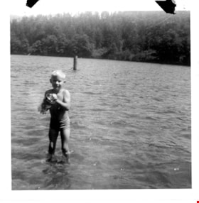
David Sanders at Whatcom Lake
https://search.heritageburnaby.ca/link/museumdescription9897
- Repository
- Burnaby Village Museum
- Date
- 1968
- Collection/Fonds
- Gerald F. Sanders and Alice Sparman Sanders fonds
- Description Level
- Item
- Physical Description
- 1 photograph : b&w ; 9 x 9 cm
- Scope and Content
- Photograph of young David Sanders standing in the water at Whatcom Lake.
- Repository
- Burnaby Village Museum
- Collection/Fonds
- Gerald F. Sanders and Alice Sparman Sanders fonds
- Description Level
- Item
- Physical Description
- 1 photograph : b&w ; 9 x 9 cm
- Material Details
- Text in red ink above photograph on album page reads: "David S. 68". Text in pencil on verso reads: "WHATCOM LAKE / I DARE YOU / TO COME NEAR! / Danny Sparman" NOTE TO CATALOGUER: hand-written note on back identifies boy as "Danny Sparman", but this is probably incorrect unless there is a Sparman cousin named Danny that we don't know about.
- Scope and Content
- Photograph of young David Sanders standing in the water at Whatcom Lake.
- Names
- Sanders, David
- Accession Code
- BV018.34.22
- Access Restriction
- No restrictions
- Reproduction Restriction
- No known restrictions
- Date
- 1968
- Media Type
- Photograph
- Scan Resolution
- 600
- Scan Date
- 2022-07-12
- Notes
- Title based on contents of photograph
Images


Deer Lake from the Baldwin House
https://search.heritageburnaby.ca/link/archivedescription37350
- Repository
- City of Burnaby Archives
- Date
- 1966
- Collection/Fonds
- Burnaby Historical Society fonds
- Description Level
- Item
- Physical Description
- 1 photograph : b&w ; 19.5 x 21.5 cm
- Scope and Content
- Photograph of Deer Lake from the corner of the Baldwin house. Two women can be seen standing on the deck at the upper level of the home, but neither are identified.
- Repository
- City of Burnaby Archives
- Date
- 1966
- Collection/Fonds
- Burnaby Historical Society fonds
- Subseries
- Baldwin family subseries
- Physical Description
- 1 photograph : b&w ; 19.5 x 21.5 cm
- Description Level
- Item
- Record No.
- 357-005
- Access Restriction
- No restrictions
- Reproduction Restriction
- Reproduce for fair dealing purposes only
- Accession Number
- BHS1998-03
- Scope and Content
- Photograph of Deer Lake from the corner of the Baldwin house. Two women can be seen standing on the deck at the upper level of the home, but neither are identified.
- Subjects
- Buildings - Heritage
- Buildings - Residential - Houses
- Geographic Features - Lakes and Ponds
- Media Type
- Photograph
- Photographer
- King, Basil
- Notes
- Title based on contents of photograph
- Geographic Access
- Deer Lake Drive
- Deer Lake
- Street Address
- 6543 Deer Lake Drive
- Historic Neighbourhood
- Burnaby Lake (Historic Neighbourhood)
- Planning Study Area
- Morley-Buckingham Area
Images

Digney Film 5 - Okanagan, Mattick's Farm and world tour
https://search.heritageburnaby.ca/link/museumdescription10661
- Repository
- Burnaby Village Museum
- Date
- [196-] (date of original), copied 2019
- Collection/Fonds
- Digney Family fonds
- Description Level
- File
- Physical Description
- 1 video recording (mp4) (54 min., 1 sec.) : digital, 16 fps, col., si.
- Scope and Content
- File consists of a film compliation created by Andy Digney and his son Ernest "Dig" Digney. The film footage is a combination of fifteen short segments taken at different times in various locations. The Film segments document the Digney family at their cottage on Okanagan Lake; a visit to Mattick's…
- Repository
- Burnaby Village Museum
- Collection/Fonds
- Digney Family fonds
- Description Level
- File
- Physical Description
- 1 video recording (mp4) (54 min., 1 sec.) : digital, 16 fps, col., si.
- Scope and Content
- File consists of a film compliation created by Andy Digney and his son Ernest "Dig" Digney. The film footage is a combination of fifteen short segments taken at different times in various locations. The Film segments document the Digney family at their cottage on Okanagan Lake; a visit to Mattick's Farm and minature railway in Victoria, British Columbia and parts of Andy Digney's world tour and ocean voyage on a passenger freighter where he travels to parts of Southeast Asia.
- Creator
- Digney, Andy
- Accession Code
- BV019.18.7
- Access Restriction
- No restrictions
- Reproduction Restriction
- No known restrictions
- Date
- [196-] (date of original), copied 2019
- Media Type
- Moving Images
- Photographer
- Digney, Ernest Frank "Dig"
- Digney, Andy
- Notes
- Title based on contents of film compilation
- Film segment originates from digitized version of original 8 mm film
- Contact Burnaby Village Museum to view content
![Gardening techniques, [1963] (date of original), digitally copied 2012 thumbnail](/media/hpo/_Data/_Archives_Images/_Unrestricted/540/549-035.jpg?width=280)
Gardening techniques
https://search.heritageburnaby.ca/link/archivedescription76915
- Repository
- City of Burnaby Archives
- Date
- [1963] (date of original), digitally copied 2012
- Collection/Fonds
- Community Heritage Commission Special Projects fonds
- Description Level
- Item
- Physical Description
- 1 photograph (jpeg) : col. ; 300ppi
- Scope and Content
- Photograph of Tony Fabian using new gardening techniques to improve his garden at Hardwick Street.
- Repository
- City of Burnaby Archives
- Date
- [1963] (date of original), digitally copied 2012
- Collection/Fonds
- Community Heritage Commission Special Projects fonds
- Physical Description
- 1 photograph (jpeg) : col. ; 300ppi
- Description Level
- Item
- Record No.
- 549-035
- Access Restriction
- No restrictions
- Reproduction Restriction
- Reproduce for fair dealing purposes only
- Accession Number
- 2012-30
- Scope and Content
- Photograph of Tony Fabian using new gardening techniques to improve his garden at Hardwick Street.
- Names
- Fabian, Tony S.
- Media Type
- Photograph
- Notes
- Title based on contents of photograph
- Geographic Access
- Hardwick Street
- Planning Study Area
- Douglas-Gilpin Area
Images
![Gardening techniques, [1963] (date of original), digitally copied 2012 thumbnail](/media/hpo/_Data/_Archives_Images/_Unrestricted/540/549-035.jpg)
![Gerald Sanders wading in a lake, [196-] thumbnail](/media/hpo/_Data/_BVM_Images/2018/2018_0034_0032_001.jpg?width=280)
Gerald Sanders wading in a lake
https://search.heritageburnaby.ca/link/museumdescription9907
- Repository
- Burnaby Village Museum
- Date
- [196-]
- Collection/Fonds
- Gerald F. Sanders and Alice Sparman Sanders fonds
- Description Level
- Item
- Physical Description
- 1 photograph : b&w ; 8.5 x 8.5 cm
- Scope and Content
- Photograph of Gerald F. Sanders on right side, walking away from the camera as he wades in a lake. He wears a white cap and carries his shoes. Shore is to the right, lake is to the left. Hills with scrub are in the background.
- Repository
- Burnaby Village Museum
- Collection/Fonds
- Gerald F. Sanders and Alice Sparman Sanders fonds
- Description Level
- Item
- Physical Description
- 1 photograph : b&w ; 8.5 x 8.5 cm
- Scope and Content
- Photograph of Gerald F. Sanders on right side, walking away from the camera as he wades in a lake. He wears a white cap and carries his shoes. Shore is to the right, lake is to the left. Hills with scrub are in the background.
- Names
- Sanders, Gerald Frank
- Accession Code
- BV018.34.32
- Access Restriction
- No restrictions
- Reproduction Restriction
- No known restrictions
- Date
- [196-]
- Media Type
- Photograph
- Scan Resolution
- 600
- Scan Date
- 2022-07-12
- Notes
- Title based on contents of photograph
Images
![Gerald Sanders wading in a lake, [196-] thumbnail](/media/hpo/_Data/_BVM_Images/2018/2018_0034_0032_001.jpg)