More like 'Burnaby General Hospital gift shop'
Narrow Results By
Person / Organization
- Anderson, Janet 1
- Anderson, Madelaine Carroll 1
- Armson, George 1
- Baldwin, Susan 2
- Balfour, H.W. 1
- Bateman, Marianne May 2
- Bayntun, Charmaine "Sherrie" Yanko 1
- Brentwood Shopping Centre 3
- British Columbia Institute of Technology 2
- British Columbia Mills Timber and Trading Company 1
- Brown, Donald N. "Don" 3
- Burnaby Art Gallery 17

Arrow Neon Sign
https://search.heritageburnaby.ca/link/landmark861
- Repository
- Burnaby Heritage Planning
- Description
- Commercial building.
- Associated Dates
- 1961
- Other Names
- Lost in the 50's Drive-in
- Street View URL
- Google Maps Street View
- Repository
- Burnaby Heritage Planning
- Other Names
- Lost in the 50's Drive-in
- Geographic Access
- Edmonds Street
- Associated Dates
- 1961
- Description
- Commercial building.
- Heritage Value
- The Arrow Neon Sign was built in 1961 by the Neonette Sign Company of New Westminster when this property was opened as the Tomahawk Drive-in Restaurant. The restaurant was later known as Lindy's Burger and in 1990, the business was renamed Lost in the 50's Drive-in. It stands 20-foot tall and is composed of a large double-sided hollow steel panel serpentine arrow mounted on a pole supporting a lexan sign panel measuring approximately 8 feet wide by 4 feet tall. The sign was designed with three illuminated features: a round lamp at the top of the pole, a double-sided rectangular fluorescent sign panel box, and two double-sided rows of orange neon arrows that follow the large serpentine arrow. The Arrow Neon Sign remains as a rare surviving example of neon sign art in the city and is the only historic neon sign in South Burnaby. The sign has gained prominence over the years as it has been associated with this small iconic drive-in which has also been utilized as a set for film production. Additionally, the drive-in has played a prominent role in the Edmonds community as a popular setting for recent "Show and Shine" participants to park their classic cars.
- Locality
- Edmonds
- Historic Neighbourhood
- East Burnaby (Historic Neighbourhood)
- Planning Study Area
- Lakeview-Mayfield Area
- Builder
- Neonette Sign Company
- Community
- Burnaby
- Contributing Resource
- Structure
- Ownership
- Public (local)
- Street Address
- 7741 Edmonds Street
- Street View URL
- Google Maps Street View
Images


Aerial photograph of Burnaby General Hospital
https://search.heritageburnaby.ca/link/archivedescription45346
- Repository
- City of Burnaby Archives
- Date
- March 18, 1961
- Collection/Fonds
- Columbian Newspaper collection
- Description Level
- Item
- Physical Description
- 1 photograph : b&w ; 19.5 x 24 cm
- Scope and Content
- Aerial photograph of the Burnaby General Hospital and surrounding area.
- Repository
- City of Burnaby Archives
- Date
- March 18, 1961
- Collection/Fonds
- Columbian Newspaper collection
- Physical Description
- 1 photograph : b&w ; 19.5 x 24 cm
- Description Level
- Item
- Record No.
- 480-241
- Access Restriction
- No restrictions
- Reproduction Restriction
- Reproduce for fair dealing purposes only
- Accession Number
- 2003-02
- Scope and Content
- Aerial photograph of the Burnaby General Hospital and surrounding area.
- Names
- Burnaby General Hospital
- Media Type
- Photograph
- Photographer
- George Allen Aerial Photos Limited
- Notes
- Title based on contents of photograph
- Photographer identifies photograph as no. 3872
- Historic Neighbourhood
- Broadview (Historic Neighbourhood)
- Planning Study Area
- Cascade-Schou Area
Images

![Burnaby General Hospital, [1961] thumbnail](/media/hpo/_Data/_Archives_Images/_Unrestricted/480/480-240.jpg?width=280)
Burnaby General Hospital
https://search.heritageburnaby.ca/link/archivedescription45345
- Repository
- City of Burnaby Archives
- Date
- [1961]
- Collection/Fonds
- Columbian Newspaper collection
- Description Level
- Item
- Physical Description
- 1 photograph : b&w ; 19 x 24 cm
- Scope and Content
- Photograph of the Burnaby General Hospital before its expansion.
- Repository
- City of Burnaby Archives
- Date
- [1961]
- Collection/Fonds
- Columbian Newspaper collection
- Physical Description
- 1 photograph : b&w ; 19 x 24 cm
- Description Level
- Item
- Record No.
- 480-240
- Access Restriction
- No restrictions
- Reproduction Restriction
- Reproduce for fair dealing purposes only
- Accession Number
- 2003-02
- Scope and Content
- Photograph of the Burnaby General Hospital before its expansion.
- Subjects
- Buildings - Civic - Hospitals
- Names
- Burnaby General Hospital
- Media Type
- Photograph
- Notes
- Title based on contents of photograph
- Geographic Access
- Kincaid Street
- Street Address
- 3935 Kincaid Street
- Historic Neighbourhood
- Broadview (Historic Neighbourhood)
- Planning Study Area
- Cascade-Schou Area
Images
![Burnaby General Hospital, [1961] thumbnail](/media/hpo/_Data/_Archives_Images/_Unrestricted/480/480-240.jpg)
![Hazel (Bongea) Padula standing on the steps of her home at High Lawn, [195-]. Item no. 549-052. thumbnail](/media/hpo/_Data/_Archives_Images/_Unrestricted/540/549-052.jpg?width=280)
Interview with Tony and Hazel Padula by Eric Damer November 27, 2012 - Track 3
https://search.heritageburnaby.ca/link/oralhistory373
- Repository
- City of Burnaby Archives
- Date Range
- 1940-1965
- Length
- 0:10:25
- Summary
- This portion of the recording pertains to Tony Padula and Hazel (Bongea) Padula's memories of night life the nineteen-forties and fifties. Tony and Hazel discuss Italian restaurants and dance halls in Vancouver and Tony mentions playing in a dance orchestra in the nineteen-forties. Tony and Hazel m…
- Repository
- City of Burnaby Archives
- Summary
- This portion of the recording pertains to Tony Padula and Hazel (Bongea) Padula's memories of night life the nineteen-forties and fifties. Tony and Hazel discuss Italian restaurants and dance halls in Vancouver and Tony mentions playing in a dance orchestra in the nineteen-forties. Tony and Hazel mention department stores in that era as well.
- Date Range
- 1940-1965
- Photo Info
- Hazel (Bongea) Padula standing on the steps of her home at High Lawn, [195-]. Item no. 549-052.
- Length
- 0:10:25
- Interviewer
- Damer, Eric
- Interview Date
- November 27, 2012
- Scope and Content
- Recording is an interview with Tony Padula and Hazel (Bongea) Padula conducted by Burnaby Village Museum employee Eric Damer, November 27, 2012. Major themes discussed are: neighbourhoods and family heritage.
- Biographical Notes
- Tony Padula’s family came to Vancouver from Italy in 1926, the year Tony was born. After graduating from school, Tony entered the shoe industry as a salesman. Hazel Bongea (later Padula) was born in 1931 in Saskatchewan and moved to Vancouver with her family when she was ten years old. After graduating from school, Hazel found work with Standard Oil in Vancouver. Tony Padula and Hazel (Bongea) Padula married in 1951. By 1953 they had bought property in the Brentwood neighbourhood of Burnaby where they built a home and began a family. The Padulas moved away in 1959 but returned five years later to a new home in central Burnaby, where they lived for twenty-two years before moving again, this time to North Vancouver. After six years in North Vancouver, Tony and Hazel retired to New Westminster.
- Total Tracks
- 8
- Total Length
- 1:09:21
- Interviewee Name
- Padula, Hazel Bongea
- Padula, Tony
- Interview Location
- Burnaby Village Museum
- Interviewer Bio
- Eric Damer is a lifelong British Columbian born in Victoria, raised in Kamloops, and currently residing in Burnaby. After studying philosophy at the University of Victoria, he became interested in the educational forces that had shaped his own life. He completed master’s and doctoral degrees in educational studies at the University of British Columbia with a particular interest in the history of adult and higher education in the province. In 2012, Eric worked for the City of Burnaby as a field researcher and writer, conducting interviews for the City Archives and Museum Oral History Program.
- Collection/Fonds
- Community Heritage Commission Special Projects fonds
- Transcript Available
- None
- Media Type
- Sound Recording
Images
![Hazel (Bongea) Padula standing on the steps of her home at High Lawn, [195-]. Item no. 549-052. thumbnail](/media/hpo/_Data/_Archives_Images/_Unrestricted/540/549-052.jpg)
Audio Tracks
Track three of recording of interview with Tony and Hazel Padula
Track three of recording of interview with Tony and Hazel Padula
https://search.heritageburnaby.ca/media/hpo/_Data/_Archives_Oral_Histories/_Unrestricted/MSS171-020/MSS171-020_Track_3.mp3
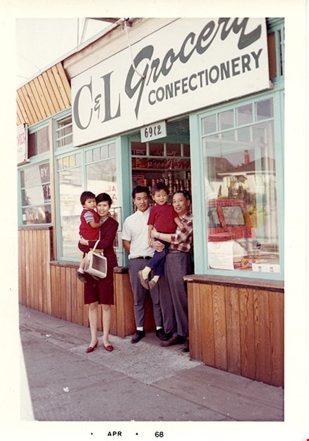
Members of Lee family in front of C&L Grocery Confectionery
https://search.heritageburnaby.ca/link/museumdescription16719
- Repository
- Burnaby Village Museum
- Date
- April 1968
- Collection/Fonds
- Quon Lip Lee fonds
- Description Level
- Item
- Physical Description
- 1 photograph (tiff)
- Scope and Content
- Photograph of Quon Lip Lee (right) and his eldest son, Gary Lee (centre) standing together with his niece and her children in front of the Lee family corner store, C&L Grocery & Confectionery. The store is located at 6912 Kingsway (corner of Kingsway and Griffiths) and was owned by Quon Lip Lee.
- Repository
- Burnaby Village Museum
- Collection/Fonds
- Quon Lip Lee fonds
- Description Level
- Item
- Physical Description
- 1 photograph (tiff)
- Scope and Content
- Photograph of Quon Lip Lee (right) and his eldest son, Gary Lee (centre) standing together with his niece and her children in front of the Lee family corner store, C&L Grocery & Confectionery. The store is located at 6912 Kingsway (corner of Kingsway and Griffiths) and was owned by Quon Lip Lee.
- Geographic Access
- Kingsway
- Street Address
- 6912 Kingsway
- Accession Code
- BV021.18.3
- Access Restriction
- No restrictions
- Reproduction Restriction
- May be restricted by third party rights
- Date
- April 1968
- Media Type
- Photograph
- Historic Neighbourhood
- Edmonds (Historic Neighbourhood)
- Planning Study Area
- Edmonds Area
- Scan Resolution
- 600
- Scan Date
- April 8, 2021
- Scale
- 100
- Notes
- Title based on contents of photograph
- Date stamp on bottom recto of photograph reads: "APR_68"
Images

Interview with Sev Morin by Rod Fowler April 4, 1990 - Track 2
https://search.heritageburnaby.ca/link/oralhistory538
- Repository
- City of Burnaby Archives
- Date Range
- 1950-1990
- Length
- 00:06:16
- Summary
- This portion of the interview is about Sev Morin’s description of Burnaby’s growth and business development along Kingsway and Hastings, the Lake City Industrial Park, and the purchase of property in 1958 for the Heritage Park and Art Gallery.
- Repository
- City of Burnaby Archives
- Summary
- This portion of the interview is about Sev Morin’s description of Burnaby’s growth and business development along Kingsway and Hastings, the Lake City Industrial Park, and the purchase of property in 1958 for the Heritage Park and Art Gallery.
- Date Range
- 1950-1990
- Photo Info
- Sev Morin (left) of Severin's in Burnaby (formerly the Gai Paree) hosting a gala New Year's celebration, 1979. Item no. 480-712
- Length
- 00:06:16
- Subjects
- Buildings - Commercial
- Buildings - Civic
- Buildings - Industrial
- Buildings - Schools - Universities and Colleges
- Historic Neighbourhood
- Central Park (Historic Neighbourhood)
- Burnaby Lake (Historic Neighbourhood)
- Vancouver Heights (Historic Neighbourhood)
- Edmonds (Historic Neighbourhood)
- Planning Study Area
- Burnaby Heights Area
- Lake City Area
- Burnaby Mountain Area
- Kingsway-Beresford Area
- Douglas-Gilpin Area
- Interviewer
- Fowler, Rod
- Interview Date
- April 4, 1990
- Scope and Content
- Recording is of an interview with Severin "Sev" Morin, conducted by Rod Fowler. Sev Morin was one of eleven participants interviewed as part of the SFU/Burnaby Centennial Committee's oral history series titled, "Voices of Burnaby". The interview is mainly about Sev Morin’s banquet hall, restaurant and night club business on Kingsway, originally named the “Gai Paree Supper Club” (1947-1976) and later “Severin’s” (1976-1985) and “Diego’s” (1985-1994), its function as a Burnaby landmark, and the entertainment and political people he met through his business. He also describes his many volunteer activities in Burnaby, including member of the SFU Senate, Rotary Club, Variety Club and Telethon, fund raising for Burnaby Hospital, and tourism related groups, and his political work for the federal Liberal party. He talks about his parents’ origins, the lives of his brothers Rudy and Rene, and the family’s involvement in establishing the “Gai Paree”. He also shares his views about the business and cultural development of Burnaby. To view “Narrow By” terms for each track expand this description and see “Notes”.
- Biographical Notes
- Severin “Sev” Rene Morin was born September 21, 1927, in Bonneville, Alberta, to Rene Pierre Morin (1878-1963) and Anne Marie (nee Lachiver) Morin (1886-1956). Mr. and Mrs. R. P. Morin and their son Rene Francois (1905-1954) immigrated to Edmonton, Alberta, from France in 1913, where Rene Pierre Morin worked for the C.N.R. and a second son Adolphe “Rudy” Ferdinand (1922-1969) was born, followed by their third son Severin. In 1943, after R.P. Morin retired, the family moved to Burnaby to a house on Sperling Avenue. Sometime earlier the two older Morin brothers found work in Trail at the smelter and developed musical careers. In 1946/47 the Morin family purchased property on Kingsway and built a banquet hall, the “Gai Paree Supper Club”. Sev and Rudy Morin managed the club and Rene F. Morin moved to Burnaby to join them with his band. The supper club, with its live music and dance floor, became a popular meeting place and wedding venue, eventually expanding into a restaurant and nightclub in the 1970s. The “Gai Paree” was renamed “Severin’s” in 1976 and “Diego’s” in 1985, closing finally in 1994. Sev Morin’s business life included three record stores which he owned with his friend Jack Cullen. Through these businesses Sev Morin was well known in the entertainment and hospitality industry. He and his restaurant also hosted political and social events that made the restaurant a community landmark. Sev Morin contributed many volunteer hours to community and charitable organizations, including an appointment to the SFU Senate, fundraising for the Burnaby Hospital, Director of the Variety Club and Rotary Club, and consultant for a variety of tourism related ventures. He also was active in the federal Liberal Party. Sev Morin and his wife Pauline married in 1950 and had three children. Sev Morin died at age 86 on March 28, 2014.
- Total Tracks
- 10
- Total Length
- 00:56:44
- Interviewee Name
- Morin, Severin "Sev"
- Interviewer Bio
- Rod Fowler returned to university as a mature student in the 1980s after working about twenty years in the field of economics and computerization in business in England, Europe and Western Canada. He graduated with a BA from SFU in both History and Sociology in 1987, his MA degree in Geography in 1989, and his PhD in Cultural Geography at SFU. He taught courses in Geography, Sociology, History and Canadian Studies at several Lower Mainland colleges, before becoming a full time member of the Geography Department at Kwantlen University College.
- Collection/Fonds
- SFU/Burnaby Centennial Committee fonds
- Transcript Available
- Transcript available
- Media Type
- Sound Recording
- Web Notes
- Interviews were digitized in 2015 allowing them to be accessible on Heritage Burnaby. The digitization project was initiated by the Community Heritage Commission with support from City of Burnaby Council.
Images

Audio Tracks
Track two of interview with Sev Morin
Track two of interview with Sev Morin
https://search.heritageburnaby.ca/media/hpo/_Data/_Archives_Oral_Histories/_Unrestricted/MSS187-021/MSS187-021_Track%202.mp3![3700 Block East Hastings, [196-] thumbnail](/media/hpo/_Data/_Archives_Images/_Unrestricted/316/366-038.jpg?width=280)
3700 Block East Hastings
https://search.heritageburnaby.ca/link/archivedescription97623
- Repository
- City of Burnaby Archives
- Date
- [196-]
- Collection/Fonds
- Burnaby Historical Society fonds
- Description Level
- Item
- Physical Description
- 1 photograph : b&w negative
- Scope and Content
- Photograph of the commercial properties located on the south side of the 3700 block of East Hastings Street. Businesses on the block include the Admiral Decorating Supply and the Trader.
- Repository
- City of Burnaby Archives
- Date
- [196-]
- Collection/Fonds
- Burnaby Historical Society fonds
- Subseries
- Municipal record subseries
- Physical Description
- 1 photograph : b&w negative
- Description Level
- Item
- Record No.
- 366-038
- Access Restriction
- No restrictions
- Reproduction Restriction
- Reproduce for fair dealing purposes only
- Accession Number
- BHS1998-12
- Scope and Content
- Photograph of the commercial properties located on the south side of the 3700 block of East Hastings Street. Businesses on the block include the Admiral Decorating Supply and the Trader.
- Subjects
- Buildings - Commercial - Stores
- Media Type
- Photograph
- Notes
- Title based on content of photograph
- Geographic Access
- Hastings Street
- Street Address
- 3700 Hastings Street
- Historic Neighbourhood
- Vancouver Heights (Historic Neighbourhood)
- Planning Study Area
- Burnaby Heights Area
Images
![3700 Block East Hastings, [196-] thumbnail](/media/hpo/_Data/_Archives_Images/_Unrestricted/316/366-038.jpg)
![3800 Block East Hastings, [196-] thumbnail](/media/hpo/_Data/_Archives_Images/_Unrestricted/316/366-039.jpg?width=280)
3800 Block East Hastings
https://search.heritageburnaby.ca/link/archivedescription97624
- Repository
- City of Burnaby Archives
- Date
- [196-]
- Collection/Fonds
- Burnaby Historical Society fonds
- Description Level
- Item
- Physical Description
- 1 photograph : b&w negative
- Scope and Content
- Photograph of the commercial properties located on the 3800 block of East Hastings Street. The sign for Halliwell's Shoe Repair at 3818 East Hastings Street is visible in the background. The photograph is taken from a low vantage point on Hastings Street, facing east.
- Repository
- City of Burnaby Archives
- Date
- [196-]
- Collection/Fonds
- Burnaby Historical Society fonds
- Subseries
- Municipal record subseries
- Physical Description
- 1 photograph : b&w negative
- Description Level
- Item
- Record No.
- 366-039
- Access Restriction
- No restrictions
- Reproduction Restriction
- Reproduce for fair dealing purposes only
- Accession Number
- BHS1998-12
- Scope and Content
- Photograph of the commercial properties located on the 3800 block of East Hastings Street. The sign for Halliwell's Shoe Repair at 3818 East Hastings Street is visible in the background. The photograph is taken from a low vantage point on Hastings Street, facing east.
- Subjects
- Buildings - Commercial - Stores
- Media Type
- Photograph
- Notes
- Title based on content of photograph
- Geographic Access
- Hastings Street
- Historic Neighbourhood
- Vancouver Heights (Historic Neighbourhood)
- Planning Study Area
- Burnaby Heights Area
Images
![3800 Block East Hastings, [196-] thumbnail](/media/hpo/_Data/_Archives_Images/_Unrestricted/316/366-039.jpg)
![3900 Block East Hastings businesses, [196-] thumbnail](/media/hpo/_Data/_Archives_Images/_Unrestricted/316/366-031.jpg?width=280)
3900 Block East Hastings businesses
https://search.heritageburnaby.ca/link/archivedescription97616
- Repository
- City of Burnaby Archives
- Date
- [196-]
- Collection/Fonds
- Burnaby Historical Society fonds
- Description Level
- Item
- Physical Description
- 1 photograph : b&w negative
- Scope and Content
- Photograph of the businesses along the north side of the 3900 block of East Hastings Street. Signs for the National Bakery at 3918 East Hastings and Tobin's Quality Shoes at 3972 East Hastings are visible. Photograph taken from the north side of Hastings facing west.
- Repository
- City of Burnaby Archives
- Date
- [196-]
- Collection/Fonds
- Burnaby Historical Society fonds
- Subseries
- Municipal record subseries
- Physical Description
- 1 photograph : b&w negative
- Description Level
- Item
- Record No.
- 366-031
- Access Restriction
- No restrictions
- Reproduction Restriction
- Reproduce for fair dealing purposes only
- Accession Number
- BHS1998-12
- Scope and Content
- Photograph of the businesses along the north side of the 3900 block of East Hastings Street. Signs for the National Bakery at 3918 East Hastings and Tobin's Quality Shoes at 3972 East Hastings are visible. Photograph taken from the north side of Hastings facing west.
- Subjects
- Buildings - Commercial - Stores
- Media Type
- Photograph
- Notes
- Title based on content of photograph
- Geographic Access
- Hastings Street
- Historic Neighbourhood
- Vancouver Heights (Historic Neighbourhood)
- Planning Study Area
- Burnaby Heights Area
Images
![3900 Block East Hastings businesses, [196-] thumbnail](/media/hpo/_Data/_Archives_Images/_Unrestricted/316/366-031.jpg)
![3900 Block East Hastings Street, [196-] thumbnail](/media/hpo/_Data/_Archives_Images/_Unrestricted/316/366-033-3.jpg?width=280)
3900 Block East Hastings Street
https://search.heritageburnaby.ca/link/archivedescription97618
- Repository
- City of Burnaby Archives
- Date
- [196-]
- Collection/Fonds
- Burnaby Historical Society fonds
- Description Level
- File
- Physical Description
- 3 photograph : b&w negatives
- Scope and Content
- Photographs of the rears of the businesses located along the 3900 block of East Hastings Street.
- Repository
- City of Burnaby Archives
- Date
- [196-]
- Collection/Fonds
- Burnaby Historical Society fonds
- Subseries
- Municipal record subseries
- Physical Description
- 3 photograph : b&w negatives
- Description Level
- File
- Record No.
- 366-033
- Access Restriction
- No restrictions
- Reproduction Restriction
- Reproduce for fair dealing purposes only
- Accession Number
- BHS1998-12
- Scope and Content
- Photographs of the rears of the businesses located along the 3900 block of East Hastings Street.
- Subjects
- Buildings - Commercial - Stores
- Media Type
- Photograph
- Notes
- Title based on content of photographs
- Geographic Access
- Hastings Street
- Historic Neighbourhood
- Vancouver Heights (Historic Neighbourhood)
- Planning Study Area
- Burnaby Heights Area
Images
![3900 Block East Hastings Street, [196-] thumbnail](/media/hpo/_Data/_Archives_Images/_Unrestricted/316/366-033-3.jpg)
![3900 Hastings Street, [between 1965 and 1970] thumbnail](/media/hpo/_Data/_Archives_Images/_Unrestricted/316/366-010.jpg?width=280)
3900 Hastings Street
https://search.heritageburnaby.ca/link/archivedescription37381
- Repository
- City of Burnaby Archives
- Date
- [between 1965 and 1970]
- Collection/Fonds
- Burnaby Historical Society fonds
- Description Level
- Item
- Physical Description
- 1 photograph : b&w negative
- Scope and Content
- Photograph taken looking west along Hastings Street, in front of the 3900 Block.
- Repository
- City of Burnaby Archives
- Date
- [between 1965 and 1970]
- Collection/Fonds
- Burnaby Historical Society fonds
- Subseries
- Municipal record subseries
- Physical Description
- 1 photograph : b&w negative
- Description Level
- Item
- Record No.
- 366-010
- Access Restriction
- No restrictions
- Reproduction Restriction
- Reproduce for fair dealing purposes only
- Accession Number
- BHS1998-12
- Scope and Content
- Photograph taken looking west along Hastings Street, in front of the 3900 Block.
- Media Type
- Photograph
- Notes
- Title based on contents of photograph
- Geographic Access
- Hastings Street
- Historic Neighbourhood
- Vancouver Heights (Historic Neighbourhood)
- Planning Study Area
- Burnaby Heights Area
Images
![3900 Hastings Street, [between 1965 and 1970] thumbnail](/media/hpo/_Data/_Archives_Images/_Unrestricted/316/366-010.jpg)
![3901 Hastings Street, [between 1965 and 1970] thumbnail](/media/hpo/_Data/_Archives_Images/_Unrestricted/316/366-011.jpg?width=280)
3901 Hastings Street
https://search.heritageburnaby.ca/link/archivedescription37382
- Repository
- City of Burnaby Archives
- Date
- [between 1965 and 1970]
- Collection/Fonds
- Burnaby Historical Society fonds
- Description Level
- Item
- Physical Description
- 1 photograph : b&w negative
- Scope and Content
- Photograph of the storefront at 3901 Hastings Street. A "for sale" sign is visible in the window.
- Repository
- City of Burnaby Archives
- Date
- [between 1965 and 1970]
- Collection/Fonds
- Burnaby Historical Society fonds
- Subseries
- Municipal record subseries
- Physical Description
- 1 photograph : b&w negative
- Description Level
- Item
- Record No.
- 366-011
- Access Restriction
- No restrictions
- Reproduction Restriction
- Reproduce for fair dealing purposes only
- Accession Number
- BHS1998-12
- Scope and Content
- Photograph of the storefront at 3901 Hastings Street. A "for sale" sign is visible in the window.
- Subjects
- Buildings - Commercial - Stores
- Media Type
- Photograph
- Notes
- Title based on contents of photograph.
- Geographic Access
- Hastings Street
- Street Address
- 3901 Hastings Street
- Historic Neighbourhood
- Vancouver Heights (Historic Neighbourhood)
- Planning Study Area
- Burnaby Heights Area
Images
![3901 Hastings Street, [between 1965 and 1970] thumbnail](/media/hpo/_Data/_Archives_Images/_Unrestricted/316/366-011.jpg)
![3951 and 3953 Hastings Street, [1965] thumbnail](/media/hpo/_Data/_Archives_Images/_Unrestricted/316/366-014.jpg?width=280)
3951 and 3953 Hastings Street
https://search.heritageburnaby.ca/link/archivedescription37385
- Repository
- City of Burnaby Archives
- Date
- [1965]
- Collection/Fonds
- Burnaby Historical Society fonds
- Description Level
- Item
- Physical Description
- 1 photograph : b&w negative
- Scope and Content
- Photograph of the buildings at 3951 and 3953 Hastings Street. A number of business signs are visible including "Paulettes Beauty Salon" and "Norburn Secondhand Store."
- Repository
- City of Burnaby Archives
- Date
- [1965]
- Collection/Fonds
- Burnaby Historical Society fonds
- Subseries
- Municipal record subseries
- Physical Description
- 1 photograph : b&w negative
- Description Level
- Item
- Record No.
- 366-014
- Access Restriction
- No restrictions
- Reproduction Restriction
- Reproduce for fair dealing purposes only
- Accession Number
- BHS1998-12
- Scope and Content
- Photograph of the buildings at 3951 and 3953 Hastings Street. A number of business signs are visible including "Paulettes Beauty Salon" and "Norburn Secondhand Store."
- Media Type
- Photograph
- Notes
- Title based on contents of photograph
- Geographic Access
- Hastings Street
- Street Address
- 3953 Hastings Street
- 3951 Hastings Street
- Historic Neighbourhood
- Vancouver Heights (Historic Neighbourhood)
- Planning Study Area
- Burnaby Heights Area
Images
![3951 and 3953 Hastings Street, [1965] thumbnail](/media/hpo/_Data/_Archives_Images/_Unrestricted/316/366-014.jpg)
![East Hastings Street, [196-] thumbnail](/media/hpo/_Data/_Archives_Images/_Unrestricted/316/366-035-1.jpg?width=280)
East Hastings Street
https://search.heritageburnaby.ca/link/archivedescription97620
- Repository
- City of Burnaby Archives
- Date
- [196-]
- Collection/Fonds
- Burnaby Historical Society fonds
- Description Level
- File
- Physical Description
- 2 photographs : b&w negatives
- Scope and Content
- Photographs of an unidentified commercial block of East Hastings Street in Burnaby. Businesses are visible in the background of the photo, featuring signs for a barbershop, grocery store, and tailoring business
- Repository
- City of Burnaby Archives
- Date
- [196-]
- Collection/Fonds
- Burnaby Historical Society fonds
- Subseries
- Municipal record subseries
- Physical Description
- 2 photographs : b&w negatives
- Description Level
- File
- Record No.
- 366-035
- Access Restriction
- No restrictions
- Reproduction Restriction
- Reproduce for fair dealing purposes only
- Accession Number
- BHS1998-12
- Scope and Content
- Photographs of an unidentified commercial block of East Hastings Street in Burnaby. Businesses are visible in the background of the photo, featuring signs for a barbershop, grocery store, and tailoring business
- Subjects
- Buildings - Commercial - Stores
- Media Type
- Photograph
- Notes
- Title based on content of photographs
- Geographic Access
- Hastings Street
- Historic Neighbourhood
- Vancouver Heights (Historic Neighbourhood)
- Planning Study Area
- Burnaby Heights Area
Images
![East Hastings Street, [196-] thumbnail](/media/hpo/_Data/_Archives_Images/_Unrestricted/316/366-035-1.jpg)
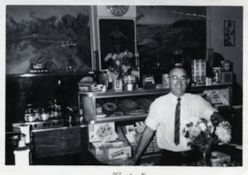
![Harry Royle at Harry's confectionery store, [1961] thumbnail](/media/hpo/_Data/_BVM_Images/2000/200500200008.jpg?width=280)
Harry Royle at Harry's confectionery store
https://search.heritageburnaby.ca/link/museumdescription1882
- Repository
- Burnaby Village Museum
- Date
- [1961]
- Collection/Fonds
- Harry Royle fonds
- Description Level
- Item
- Physical Description
- 1 photograph : b&w ; 7.5 x 9.5 cm
- Scope and Content
- Photograph of Harry Royle standing behind the counter of his confectionery store, "Harry's" at Ellesmere and Hastings in Capitol Hill. He is looking at the camera and smiling, surrounded by various confectionery. There are posters hanging on the wall and trophies displayed on shelves in the backgro…
- Repository
- Burnaby Village Museum
- Collection/Fonds
- Harry Royle fonds
- Description Level
- Item
- Physical Description
- 1 photograph : b&w ; 7.5 x 9.5 cm
- Scope and Content
- Photograph of Harry Royle standing behind the counter of his confectionery store, "Harry's" at Ellesmere and Hastings in Capitol Hill. He is looking at the camera and smiling, surrounded by various confectionery. There are posters hanging on the wall and trophies displayed on shelves in the background.
- Geographic Access
- Hastings Street
- Street Address
- 5527 Hastings Street
- Accession Code
- BV005.20.8
- Access Restriction
- No restrictions
- Reproduction Restriction
- May be restricted by third party rights
- Date
- [1961]
- Media Type
- Photograph
- Historic Neighbourhood
- Capitol Hill (Historic Neighbourhood)
- Planning Study Area
- Capitol Hill Area
- Scan Resolution
- 600
- Scan Date
- 1/12/2010
- Scale
- 100
- Notes
- Title based on contents of photograph
- Stamp on verso of photograph reads: "952D01 POLAROID"
- The Bulova clock hanging on the wall is at 5:49
Images
![Harry Royle at Harry's confectionery store, [1961] thumbnail](/media/hpo/_Data/_BVM_Images/2000/200500200008.jpg)
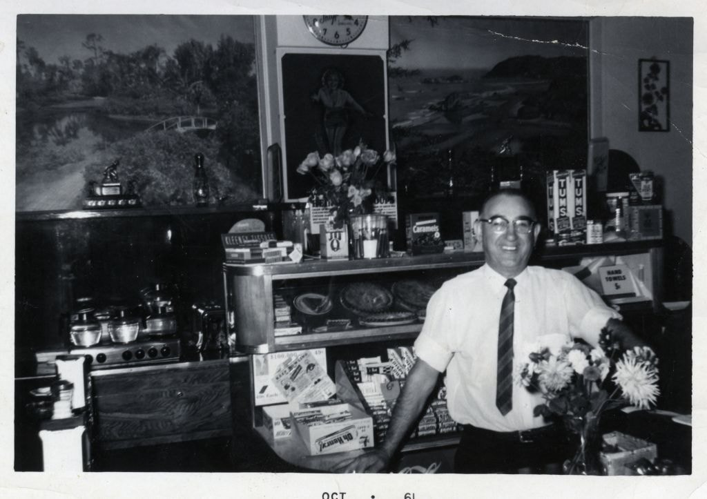
Harry Royle at Harry's confectionery store
https://search.heritageburnaby.ca/link/museumdescription1883
- Repository
- Burnaby Village Museum
- Date
- October 1961
- Collection/Fonds
- Harry Royle fonds
- Description Level
- Item
- Physical Description
- 1 photograph : b&w ; 7.5 x 11.5 cm
- Scope and Content
- Photograph of Harry Royle standing behind the counter of his confectionery store, "Harry's" at Ellesmere and Hastings in Capitol Hill. He is looking at the camera and smiling, surrounded by various confectionery. There are posters hanging on the wall and trophies displayed on shelves in the backgro…
- Repository
- Burnaby Village Museum
- Collection/Fonds
- Harry Royle fonds
- Description Level
- Item
- Physical Description
- 1 photograph : b&w ; 7.5 x 11.5 cm
- Scope and Content
- Photograph of Harry Royle standing behind the counter of his confectionery store, "Harry's" at Ellesmere and Hastings in Capitol Hill. He is looking at the camera and smiling, surrounded by various confectionery. There are posters hanging on the wall and trophies displayed on shelves in the background.
- Geographic Access
- Hastings Street
- Street Address
- 5527 Hastings Street
- Accession Code
- BV005.20.9
- Access Restriction
- No restrictions
- Reproduction Restriction
- May be restricted by third party rights
- Date
- October 1961
- Media Type
- Photograph
- Historic Neighbourhood
- Capitol Hill (Historic Neighbourhood)
- Planning Study Area
- Capitol Hill Area
- Scan Resolution
- 600
- Scan Date
- 1/12/2010
- Scale
- 100
- Notes
- Title based on contents of photograph
- Date stamp on recto of photograph's border reads: "OCT 61"
Images
![Hasting Street storefront, [196-] thumbnail](/media/hpo/_Data/_Archives_Images/_Unrestricted/316/366-034.jpg?width=280)
Hasting Street storefront
https://search.heritageburnaby.ca/link/archivedescription97619
- Repository
- City of Burnaby Archives
- Date
- [196-]
- Collection/Fonds
- Burnaby Historical Society fonds
- Description Level
- Item
- Physical Description
- 1 photograph : b&w ; 9 x 9 cm
- Scope and Content
- Photograph of the side and front of an unidentified business on East Hastings Street.
- Repository
- City of Burnaby Archives
- Date
- [196-]
- Collection/Fonds
- Burnaby Historical Society fonds
- Subseries
- Municipal record subseries
- Physical Description
- 1 photograph : b&w ; 9 x 9 cm
- Description Level
- Item
- Record No.
- 366-034
- Access Restriction
- No restrictions
- Reproduction Restriction
- Reproduce for fair dealing purposes only
- Accession Number
- BHS1998-12
- Scope and Content
- Photograph of the side and front of an unidentified business on East Hastings Street.
- Subjects
- Buildings - Commercial - Stores
- Media Type
- Photograph
- Notes
- Title based on content of photograph
- Geographic Access
- Hastings Street
- Historic Neighbourhood
- Vancouver Heights (Historic Neighbourhood)
- Planning Study Area
- Burnaby Heights Area
Images
![Hasting Street storefront, [196-] thumbnail](/media/hpo/_Data/_Archives_Images/_Unrestricted/316/366-034.jpg)
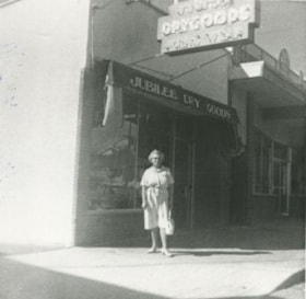
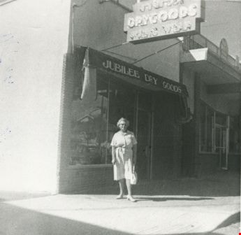
Jubilee Dry Goods Store
https://search.heritageburnaby.ca/link/archivedescription35767
- Repository
- City of Burnaby Archives
- Date
- 1965 (date of original), copied 1986
- Collection/Fonds
- Burnaby Historical Society fonds
- Description Level
- Item
- Physical Description
- 1 photograph : b&w ; 12.7 x 17.8 cm print
- Scope and Content
- Photograph of Gwen Pitman, store manager, in front of Jubilee Dry Goods. The store was founded by Ernest Pitman, her father, and closed in 1971. It was located at 6730 Jubilee Avenue, later the site of Bonsor Park.
- Repository
- City of Burnaby Archives
- Date
- 1965 (date of original), copied 1986
- Collection/Fonds
- Burnaby Historical Society fonds
- Subseries
- Pioneer Tales subseries
- Physical Description
- 1 photograph : b&w ; 12.7 x 17.8 cm print
- Description Level
- Item
- Record No.
- 204-625
- Access Restriction
- No restrictions
- Reproduction Restriction
- Reproduce for fair dealing purposes only
- Accession Number
- BHS1988-03
- Scope and Content
- Photograph of Gwen Pitman, store manager, in front of Jubilee Dry Goods. The store was founded by Ernest Pitman, her father, and closed in 1971. It was located at 6730 Jubilee Avenue, later the site of Bonsor Park.
- Subjects
- Buildings - Commercial - Stores
- Media Type
- Photograph
- Notes
- Title based on contents of photograph
- Geographic Access
- Jubilee Avenue
- Street Address
- 6730 Jubilee Avenue
- Historic Neighbourhood
- Central Park (Historic Neighbourhood)
- Planning Study Area
- Marlborough Area
Images
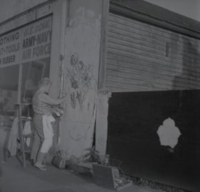
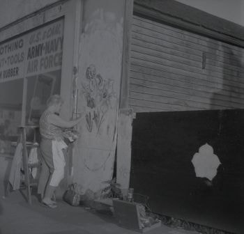
Painter working on a mural
https://search.heritageburnaby.ca/link/archivedescription34628
- Repository
- City of Burnaby Archives
- Date
- July 15, 1966
- Collection/Fonds
- Burnaby Historical Society fonds
- Description Level
- Item
- Physical Description
- 1 photograph : b&w negative ; 4.5 x 4.6 cm
- Scope and Content
- Photograph of a painter working on a mural beside an store as part of the Burnaby Historical Society's Paint-In on Hastings Street. The store's sign reads in part: "[Clothing] / Tools / Rubber / U.S. & Can. Army, Navy, Air Force."
- Repository
- City of Burnaby Archives
- Date
- July 15, 1966
- Collection/Fonds
- Burnaby Historical Society fonds
- Subseries
- Photographs subseries
- Physical Description
- 1 photograph : b&w negative ; 4.5 x 4.6 cm
- Description Level
- Item
- Record No.
- 066-032
- Access Restriction
- No restrictions
- Reproduction Restriction
- Reproduce for fair dealing purposes only
- Accession Number
- BHS2007-04
- Scope and Content
- Photograph of a painter working on a mural beside an store as part of the Burnaby Historical Society's Paint-In on Hastings Street. The store's sign reads in part: "[Clothing] / Tools / Rubber / U.S. & Can. Army, Navy, Air Force."
- Media Type
- Photograph
- Notes
- Title based on contents of photograph
- Geographic Access
- Hastings Street
Images
![Paulette's Beauty Salon, [196-] thumbnail](/media/hpo/_Data/_Archives_Images/_Unrestricted/316/366-030.jpg?width=280)
Paulette's Beauty Salon
https://search.heritageburnaby.ca/link/archivedescription97615
- Repository
- City of Burnaby Archives
- Date
- [196-]
- Collection/Fonds
- Burnaby Historical Society fonds
- Description Level
- Item
- Physical Description
- 1 photograph : b&w negative
- Scope and Content
- Photograph of Paulette's Beauty Salon located at 3945 East Hastings Street in North Burnaby.
- Repository
- City of Burnaby Archives
- Date
- [196-]
- Collection/Fonds
- Burnaby Historical Society fonds
- Subseries
- Municipal record subseries
- Physical Description
- 1 photograph : b&w negative
- Description Level
- Item
- Record No.
- 366-030
- Access Restriction
- No restrictions
- Reproduction Restriction
- Reproduce for fair dealing purposes only
- Accession Number
- BHS1998-12
- Scope and Content
- Photograph of Paulette's Beauty Salon located at 3945 East Hastings Street in North Burnaby.
- Subjects
- Buildings - Commercial - Stores
- Names
- Paulettes Beauty Salon
- Media Type
- Photograph
- Notes
- Title based on content of photograph
- Geographic Access
- Hastings Street
- Historic Neighbourhood
- Vancouver Heights (Historic Neighbourhood)
- Planning Study Area
- Burnaby Heights Area
Images
![Paulette's Beauty Salon, [196-] thumbnail](/media/hpo/_Data/_Archives_Images/_Unrestricted/316/366-030.jpg)