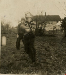
More like 'Looking east from north side of 5118 Douglas Road - The Roberts House'
Narrow Results By
Decade
- 2020s
- 2010s 40
- 2000s 480
- 1990s 378
- 1980s 370
- 1970s 719
- 1960s
- 1950s 462
- 1940s 419
- 1930s 348
- 1920s 370
- 1910s 440
- 1900s 173
- 1890s 23
- 1880s 49
- 1870s 3
- 1860s 1
- 1850s 1
- 1840s 1
- 1830s 1
- 1820s 1
- 1810s 1
- 1800s 1
- 1790s 1
- 1780s 1
- 1770s 1
- 1760s 1
- 1750s 1
- 1740s 1
- 1730s 1
- 1720s 1
- 1710s 1
- 1700s 1
- 1690s 1
- 1680s 1
- 1670s 1
- 1660s 1
- 1650s 1
- 1640s 1
- 1630s 1
- 1620s 1
- 1610s 1
- 1600s 1
![Looking north from 5486 Dominion Street, [between 1965 and 1966] thumbnail](/media/hpo/_Data/_Archives_Images/_Unrestricted/600/620-030.jpg?width=280)
Looking north from 5486 Dominion Street
https://search.heritageburnaby.ca/link/archivedescription91849
- Repository
- City of Burnaby Archives
- Date
- [between 1965 and 1966]
- Collection/Fonds
- Small family fonds
- Description Level
- Item
- Physical Description
- 1 photograph : b&w ; 9 cm x 9.5 cm
- Scope and Content
- Photograph of the McLeans' house at 5493 Dominion Street (left) and the Brocklebank's house at 3071 Douglas Road (right). The photograph is taken from 5486 Dominion Street, looking north.
- Repository
- City of Burnaby Archives
- Date
- [between 1965 and 1966]
- Collection/Fonds
- Small family fonds
- Physical Description
- 1 photograph : b&w ; 9 cm x 9.5 cm
- Description Level
- Item
- Record No.
- 620-030
- Access Restriction
- No restrictions
- Reproduction Restriction
- No reproduction permitted
- Accession Number
- 2017-01
- Scope and Content
- Photograph of the McLeans' house at 5493 Dominion Street (left) and the Brocklebank's house at 3071 Douglas Road (right). The photograph is taken from 5486 Dominion Street, looking north.
- Subjects
- Buildings - Residential - Houses
- Media Type
- Photograph
- Notes
- Transcribed title
- Title transcribed from donor's notes
- Note in blue ink on verso of photograph reads: "P.30"
- Note in blue ink on verso of photograph reads: "McLean's, Kamberg's, Brocklebank's houses. / Prob. 1965 or '66"
- 5493 Dominion Street was previously numbered 3107 Dominion Street and was later subdivided into two lots: 5491 and 5495 Dominion Street.
- Street Address
- 3071 Douglas Road
- 5493 Dominion Street
- Historic Neighbourhood
- Burnaby Lake (Historic Neighbourhood)
- Planning Study Area
- Ardingley-Sprott Area
Images
![Looking north from 5486 Dominion Street, [between 1965 and 1966] thumbnail](/media/hpo/_Data/_Archives_Images/_Unrestricted/600/620-030.jpg)
![Looking north from 5486 Dominion Street, [1969] thumbnail](/media/hpo/_Data/_Archives_Images/_Unrestricted/600/620-031.jpg?width=280)
Looking north from 5486 Dominion Street
https://search.heritageburnaby.ca/link/archivedescription91850
- Repository
- City of Burnaby Archives
- Date
- [1969]
- Collection/Fonds
- Small family fonds
- Description Level
- Item
- Physical Description
- 1 photograph : b&w ; 9 cm x 12 cm
- Scope and Content
- Photograph of the McLeans' house at 5493 Dominion Street with a Volkswagon Beetle parked on the street in front. The Brocklebanks's backyard at 3071 Douglas Road is visible on the right. The photograph was taken from 5486 Dominion Street, looking north.
- Repository
- City of Burnaby Archives
- Date
- [1969]
- Collection/Fonds
- Small family fonds
- Physical Description
- 1 photograph : b&w ; 9 cm x 12 cm
- Description Level
- Item
- Record No.
- 620-031
- Access Restriction
- No restrictions
- Reproduction Restriction
- No reproduction permitted
- Accession Number
- 2017-01
- Scope and Content
- Photograph of the McLeans' house at 5493 Dominion Street with a Volkswagon Beetle parked on the street in front. The Brocklebanks's backyard at 3071 Douglas Road is visible on the right. The photograph was taken from 5486 Dominion Street, looking north.
- Media Type
- Photograph
- Notes
- Transcribed title
- Title transcribed from donor's notes
- Note in blue ink on verso of photograph reads: "P.31"
- Note in blue ink on verso of photograph reads: "(McLean's) / 5493 Domion [sic] St (left) (3071 Douglas Rd / Brocklebanks back yard / (right)"
- Note in blue ink of verso of photograph reads: "?-11-69 probably ?"
- 5493 Dominion Street was previously numbered 3107 Dominion Street and was later subdivided into two lots: 5491 and 5495 Dominion Street.
- Photograph 620-032 was taken from the same vantage point
- Street Address
- 3071 Douglas Road
- 5493 Dominion Street
- Historic Neighbourhood
- Burnaby Lake (Historic Neighbourhood)
- Planning Study Area
- Ardingley-Sprott Area
Images
![Looking north from 5486 Dominion Street, [1969] thumbnail](/media/hpo/_Data/_Archives_Images/_Unrestricted/600/620-031.jpg)
![Looking southeast from 5118 Douglas Road - The Roberts House, [between 1960 and 1975] thumbnail](/media/hpo/_Data/_Archives_Images/_Unrestricted/600/620-011.jpg?width=280)
Looking southeast from 5118 Douglas Road - The Roberts House
https://search.heritageburnaby.ca/link/archivedescription91830
- Repository
- City of Burnaby Archives
- Date
- [between 1960 and 1975]
- Collection/Fonds
- Small family fonds
- Description Level
- Item
- Physical Description
- 1 photograph : b&w ; 12.5 cm x 9 cm
- Scope and Content
- Photograph of the Manahan family's house, taken from 5118 Douglas Road, looking southeast. In the 1960s the Meyers sold a portion of their property at to the Manahan family and the house in the centre of the photograph was built. The address of the house is unknown. To the right, the Meyers' hou…
- Repository
- City of Burnaby Archives
- Date
- [between 1960 and 1975]
- Collection/Fonds
- Small family fonds
- Physical Description
- 1 photograph : b&w ; 12.5 cm x 9 cm
- Description Level
- Item
- Record No.
- 620-011
- Access Restriction
- No restrictions
- Reproduction Restriction
- No reproduction permitted
- Accession Number
- 2017-01
- Scope and Content
- Photograph of the Manahan family's house, taken from 5118 Douglas Road, looking southeast. In the 1960s the Meyers sold a portion of their property at to the Manahan family and the house in the centre of the photograph was built. The address of the house is unknown. To the right, the Meyers' house is partially visible.
- Subjects
- Buildings - Residential - Houses
- Media Type
- Photograph
- Notes
- Transcribed title
- Title transcribed from donor's notes
- 5106 Douglas Road later subdivided into 5539 and 5545 Norfolk Street
- Note in blue ink on verso of photograph reads: "(Meyers House on Right)"
- Note in blue ink on verso of photograph reads: "P11"
- Note in blue ink on verso of photograph reads: "Manahan's House"
- Note in blue ink on verso of photograph reads: "1960's or early 1970s"
- Street Address
- 5106 Douglas Road
- Historic Neighbourhood
- Burnaby Lake (Historic Neighbourhood)
- Planning Study Area
- Ardingley-Sprott Area
Images
![Looking southeast from 5118 Douglas Road - The Roberts House, [between 1960 and 1975] thumbnail](/media/hpo/_Data/_Archives_Images/_Unrestricted/600/620-011.jpg)
Looking west from back yard of 5486 Dominion Street
https://search.heritageburnaby.ca/link/archivedescription91869
- Repository
- City of Burnaby Archives
- Date
- 1961
- Collection/Fonds
- Small family fonds
- Description Level
- Item
- Physical Description
- 1 photograph : sepia ; 8 cm x 6.5 cm
- Scope and Content
- Photograph of Martin and Charles Shaw playing the backyard at 5486 Dominion Street. The house at 5466 Dominion Street, which likely predates the Roberts' house, is visible in the background. The photograph was taken from the backyard of 5486 Dominion Street, looking west.
- Repository
- City of Burnaby Archives
- Date
- 1961
- Collection/Fonds
- Small family fonds
- Physical Description
- 1 photograph : sepia ; 8 cm x 6.5 cm
- Description Level
- Item
- Record No.
- 620-050
- Access Restriction
- No restrictions
- Reproduction Restriction
- No reproduction permitted
- Accession Number
- 2017-01
- Scope and Content
- Photograph of Martin and Charles Shaw playing the backyard at 5486 Dominion Street. The house at 5466 Dominion Street, which likely predates the Roberts' house, is visible in the background. The photograph was taken from the backyard of 5486 Dominion Street, looking west.
- Media Type
- Photograph
- Notes
- Transcribed title
- Title transcribed from donor's notes
- Note in blue ink on verso of photograph reads: "P12"
- Note in blue ink on verso of photograph reads: "Charles 7 / Martin 5"
- Note in blue ink on verso of photograph reads: "Between March and Jun 1961"
- 5486 Dominion Street later subdivided into two lots: 5480 and 5488 Dominion Street
- 5466 Dominion Street later subdivided into two lots: 5462 and 5468 Dominion Street
- Street Address
- 5466 Dominion Street
- 5486 Dominion Street
- Historic Neighbourhood
- Burnaby Lake (Historic Neighbourhood)
- Planning Study Area
- Ardingley-Sprott Area
Images


Looking west from Douglas Road
https://search.heritageburnaby.ca/link/archivedescription91832
- Repository
- City of Burnaby Archives
- Date
- 1969
- Collection/Fonds
- Small family fonds
- Description Level
- Item
- Physical Description
- 1 photograph : b&w ; 9 cm x 12.5 cm
- Scope and Content
- Photograph of Roberts' house and front lawn at 3131 Douglas Road (previously 5118 Douglas Road). The photograph was taken from Douglas Road, looking west.
- Repository
- City of Burnaby Archives
- Date
- 1969
- Collection/Fonds
- Small family fonds
- Physical Description
- 1 photograph : b&w ; 9 cm x 12.5 cm
- Description Level
- Item
- Record No.
- 620-013
- Access Restriction
- No restrictions
- Reproduction Restriction
- No reproduction permitted
- Accession Number
- 2017-01
- Scope and Content
- Photograph of Roberts' house and front lawn at 3131 Douglas Road (previously 5118 Douglas Road). The photograph was taken from Douglas Road, looking west.
- Subjects
- Buildings - Residential - Houses
- Media Type
- Photograph
- Notes
- Transcribed title
- Title transcribed from donor's notes
- Note in black ink on verso of photograph reads: "1969 / Roberts' house and front lawn"
- Note in blue ink on verso of photograph reads: "P.13"
- Stamp in black ink on verso of photograph reads: "11.8.69"
- 5118 Douglas Road renumbered to 3131 Douglas Road in 1958 and to 5538 Dominion Street in 1970 or 1971
- Street Address
- 3131 Douglas Road
- 5118 Douglas Road
- 5538 Dominion Street
- Historic Neighbourhood
- Burnaby Lake (Historic Neighbourhood)
- Planning Study Area
- Ardingley-Sprott Area
Images
Matheson family home
https://search.heritageburnaby.ca/link/archivedescription37667
- Repository
- City of Burnaby Archives
- Date
- 1962 (date of original), copied 1991
- Collection/Fonds
- Burnaby Historical Society fonds
- Description Level
- Item
- Physical Description
- 1 photograph : b&w ; 3.3 x 5.4 cm print on contact sheet 20.2 x 25.3 cm
- Scope and Content
- Photograph of the Matheson family home at 6149 McKay Avenue (formerly numbered 2890 McKay Avenue). It was built in the spring of 1926.
- Repository
- City of Burnaby Archives
- Date
- 1962 (date of original), copied 1991
- Collection/Fonds
- Burnaby Historical Society fonds
- Subseries
- Burnaby Image Bank subseries
- Physical Description
- 1 photograph : b&w ; 3.3 x 5.4 cm print on contact sheet 20.2 x 25.3 cm
- Description Level
- Item
- Record No.
- 370-255
- Access Restriction
- No restrictions
- Reproduction Restriction
- No restrictions
- Accession Number
- BHS1999-03
- Scope and Content
- Photograph of the Matheson family home at 6149 McKay Avenue (formerly numbered 2890 McKay Avenue). It was built in the spring of 1926.
- Subjects
- Buildings - Residential - Houses
- Media Type
- Photograph
- Notes
- Title based on contents of photograph
- 1 b&w copy negative accompanying
- Negative has a pink cast
- Geographic Access
- McKay Avenue
- Street Address
- 6149 McKay Avenue
- Historic Neighbourhood
- Central Park (Historic Neighbourhood)
- Planning Study Area
- Maywood Area
Images

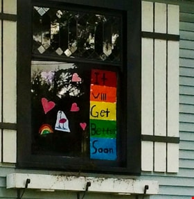
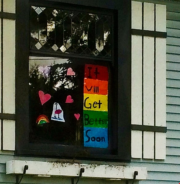
Messages of Comfort
https://search.heritageburnaby.ca/link/archivedescription95090
- Repository
- City of Burnaby Archives
- Date
- April 25, 2020
- Collection/Fonds
- Burnaby Photographic Society fonds
- Description Level
- Item
- Physical Description
- 1 photograph (tiff)
- Scope and Content
- Photograph of a window of a private residence in south east Burnaby. The window is decorated in support of health care workers with a colourful sign in the window reading: "It Will Get Better Soon".
- Repository
- City of Burnaby Archives
- Date
- April 25, 2020
- Collection/Fonds
- Burnaby Photographic Society fonds
- Physical Description
- 1 photograph (tiff)
- Description Level
- Item
- Record No.
- 623-009
- Access Restriction
- No restrictions
- Reproduction Restriction
- Reproduce for fair dealing purposes only
- Accession Number
- 2020-10
- Scope and Content
- Photograph of a window of a private residence in south east Burnaby. The window is decorated in support of health care workers with a colourful sign in the window reading: "It Will Get Better Soon".
- Subjects
- Buildings - Residential - Houses
- Media Type
- Photograph
- Photographer
- Asbia, Cher
- Notes
- Transcribed title
Images
![North Side of 3900 Albert Street, [between 1965 and 1970] thumbnail](/media/hpo/_Data/_Archives_Images/_Unrestricted/316/366-020.jpg?width=280)
North Side of 3900 Albert Street
https://search.heritageburnaby.ca/link/archivedescription37391
- Repository
- City of Burnaby Archives
- Date
- [between 1965 and 1970]
- Collection/Fonds
- Burnaby Historical Society fonds
- Description Level
- Item
- Physical Description
- 1 photograph : b&w negative
- Scope and Content
- Photograph of a car parked in front of a row of houses on the north side of 3900 Albert Street.
- Repository
- City of Burnaby Archives
- Date
- [between 1965 and 1970]
- Collection/Fonds
- Burnaby Historical Society fonds
- Subseries
- Municipal record subseries
- Physical Description
- 1 photograph : b&w negative
- Description Level
- Item
- Record No.
- 366-020
- Access Restriction
- No restrictions
- Reproduction Restriction
- Reproduce for fair dealing purposes only
- Accession Number
- BHS1998-12
- Scope and Content
- Photograph of a car parked in front of a row of houses on the north side of 3900 Albert Street.
- Media Type
- Photograph
- Notes
- Title based on contents of photograph
- Geographic Access
- Albert Street
- Street Address
- 3900 Albert Street
- Historic Neighbourhood
- Vancouver Heights (Historic Neighbourhood)
- Planning Study Area
- Burnaby Heights Area
Images
![North Side of 3900 Albert Street, [between 1965 and 1970] thumbnail](/media/hpo/_Data/_Archives_Images/_Unrestricted/316/366-020.jpg)
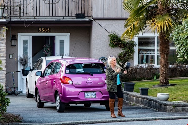
Pots & Pans
https://search.heritageburnaby.ca/link/archivedescription95124
- Repository
- City of Burnaby Archives
- Date
- April 8, 2020
- Collection/Fonds
- Burnaby Photographic Society fonds
- Description Level
- Item
- Physical Description
- 1 photograph (tiff)
- Scope and Content
- Photograph of Burnaby resident Michelle Leone banging a pot at the end of her driveway in support of healthcare workers.
- Repository
- City of Burnaby Archives
- Date
- April 8, 2020
- Collection/Fonds
- Burnaby Photographic Society fonds
- Physical Description
- 1 photograph (tiff)
- Description Level
- Item
- Record No.
- 623-042
- Access Restriction
- No restrictions
- Reproduction Restriction
- Reproduce for fair dealing purposes only
- Accession Number
- 2020-10
- Scope and Content
- Photograph of Burnaby resident Michelle Leone banging a pot at the end of her driveway in support of healthcare workers.
- Media Type
- Photograph
- Photographer
- Jerome, Ron
- Notes
- Transcribed title
- Geographic Access
- Heathdale Court
- Street Address
- 5386 Heathdale Court
- Planning Study Area
- Parkcrest-Aubrey Area
Images

Radiate Positive Vibes
https://search.heritageburnaby.ca/link/archivedescription95085
- Repository
- City of Burnaby Archives
- Date
- May 20, 2020
- Collection/Fonds
- Burnaby Photographic Society fonds
- Description Level
- Item
- Physical Description
- 1 photograph (tiff)
- Scope and Content
- Photograph of a multi-coloured chalk drawing in the lane connecting Laurel Street and Hyde Street, at Godwin Avenue. The drawing contains the message "Radiate Positive Vibes" surrounded by wavy concentric rings.
- Repository
- City of Burnaby Archives
- Date
- May 20, 2020
- Collection/Fonds
- Burnaby Photographic Society fonds
- Physical Description
- 1 photograph (tiff)
- Description Level
- Item
- Record No.
- 623-004
- Access Restriction
- No restrictions
- Reproduction Restriction
- No restrictions
- Accession Number
- 2020-10
- Scope and Content
- Photograph of a multi-coloured chalk drawing in the lane connecting Laurel Street and Hyde Street, at Godwin Avenue. The drawing contains the message "Radiate Positive Vibes" surrounded by wavy concentric rings.
- Subjects
- Buildings - Residential - Houses
- Media Type
- Photograph
- Photographer
- Gervan, Bonnie
- Notes
- Transcribed title
- Photographer's caption: "Chalk work by young resident reminding the neighbourhood to try and stay positive during the pandemic."
- Geographic Access
- Laurel Street
- Hyde Street
- Godwin Avenue
- Historic Neighbourhood
- Burnaby Lake (Historic Neighbourhood)
- Planning Study Area
- Douglas-Gilpin Area
Images

![Residential streets, [196-] thumbnail](/media/hpo/_Data/_Archives_Images/_Unrestricted/316/366-028-10.jpg?width=280)
Residential streets
https://search.heritageburnaby.ca/link/archivedescription97613
- Repository
- City of Burnaby Archives
- Date
- [196-]
- Collection/Fonds
- Burnaby Historical Society fonds
- Description Level
- File
- Physical Description
- 22 photographs : b&w negatives
- Scope and Content
- Photographs of various residential streets and houses in North Burnaby. Streets and house numbers are not identified.
- Repository
- City of Burnaby Archives
- Date
- [196-]
- Collection/Fonds
- Burnaby Historical Society fonds
- Subseries
- Municipal record subseries
- Physical Description
- 22 photographs : b&w negatives
- Description Level
- File
- Record No.
- 366-028
- Access Restriction
- No restrictions
- Reproduction Restriction
- Reproduce for fair dealing purposes only
- Accession Number
- BHS1998-12
- Scope and Content
- Photographs of various residential streets and houses in North Burnaby. Streets and house numbers are not identified.
- Media Type
- Photograph
- Notes
- Title based on content of photographs
Images
![Residential streets, [196-] thumbnail](/media/hpo/_Data/_Archives_Images/_Unrestricted/316/366-028-10.jpg)
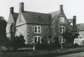
Rowborough Farm
https://search.heritageburnaby.ca/link/archivedescription36206
- Repository
- City of Burnaby Archives
- Date
- 1963
- Collection/Fonds
- Burnaby Historical Society fonds
- Description Level
- Item
- Physical Description
- 1 photograph : b&w ; 7.5 x 11.5 cm print
- Scope and Content
- Photograph of a very large stone building called the Rowborogh Farm, the Love family home in England.
- Repository
- City of Burnaby Archives
- Date
- 1963
- Collection/Fonds
- Burnaby Historical Society fonds
- Subseries
- Love family subseries
- Physical Description
- 1 photograph : b&w ; 7.5 x 11.5 cm print
- Description Level
- Item
- Record No.
- 232-003
- Access Restriction
- No restrictions
- Reproduction Restriction
- Reproduce for fair dealing purposes only
- Accession Number
- BHS1989-24
- Scope and Content
- Photograph of a very large stone building called the Rowborogh Farm, the Love family home in England.
- Media Type
- Photograph
- Notes
- Title based on contents of photograph
- 1 b&w copy negative accompanying
Images
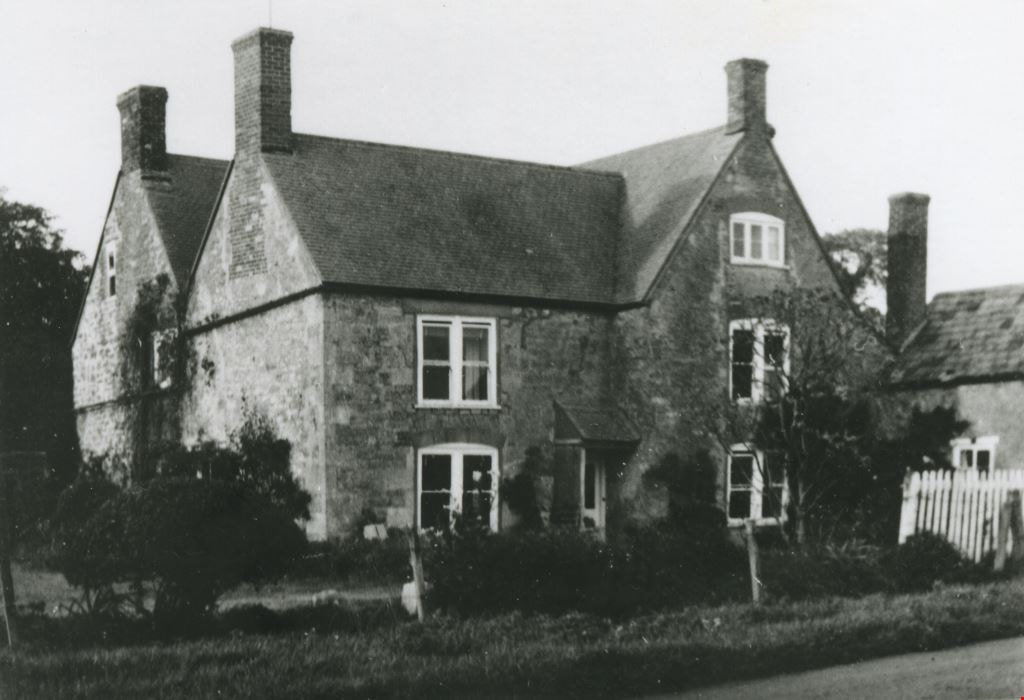
![Rowborough Farm, [1963] (date of original), copied 2016 thumbnail](/media/hpo/_Data/_BVM_Images/2016/2016_0043_0080_001.jpg?width=280)
Rowborough Farm
https://search.heritageburnaby.ca/link/museumdescription4181
- Repository
- Burnaby Village Museum
- Date
- [1963] (date of original), copied 2016
- Collection/Fonds
- Esther Love Stanley fonds
- Description Level
- Item
- Physical Description
- 1 photograph (tiff)
- Scope and Content
- Photograph of a large brick house, located in England, called Rowborough Farm. It was Jesse Love's home before he moved to Canada.
- Repository
- Burnaby Village Museum
- Collection/Fonds
- Esther Love Stanley fonds
- Description Level
- Item
- Physical Description
- 1 photograph (tiff)
- Material Details
- Handwritten text on front reads: ""Rowborough Farm 1963 / Jesse Love's Home in South Marston, Swindon, England".
- Scope and Content
- Photograph of a large brick house, located in England, called Rowborough Farm. It was Jesse Love's home before he moved to Canada.
- Subjects
- Buildings - Residential - Houses
- Accession Code
- BV016.43.80
- Access Restriction
- No restrictions
- Reproduction Restriction
- May be restricted by third party rights
- Date
- [1963] (date of original), copied 2016
- Media Type
- Photograph
- Notes
- Title based on contents of photograph.
- Image is from a binder of family history. Binder 3, fruit illustrations on cover, "Family Tree Photos".
- Digital image created from orginal photograph by donor
Images
![Rowborough Farm, [1963] (date of original), copied 2016 thumbnail](/media/hpo/_Data/_BVM_Images/2016/2016_0043_0080_001.jpg)
![Sanderson family home, [between 1950 and 1969] thumbnail](/media/hpo/_Data/_Archives_Images/_Unrestricted/513/521-022.jpg?width=280)
Sanderson family home
https://search.heritageburnaby.ca/link/archivedescription65790
- Repository
- City of Burnaby Archives
- Date
- [between 1950 and 1969]
- Collection/Fonds
- Field family fonds
- Description Level
- Item
- Physical Description
- 1 photograph (tiff) ; 600 ppi
- Scope and Content
- Photograph of the Sanderson family home (believed to be located at 3812/5457 Inman Avenue, one block north of Central Park). A larger house which still stands on this property replaced this house in 1921.
- Repository
- City of Burnaby Archives
- Date
- [between 1950 and 1969]
- Collection/Fonds
- Field family fonds
- Physical Description
- 1 photograph (tiff) ; 600 ppi
- Material Details
- Item is a scan of a b&w photograph
- Description Level
- Item
- Record No.
- 521-022
- Access Restriction
- No restrictions
- Reproduction Restriction
- Reproduce for fair dealing purposes only
- Accession Number
- 2010-14
- Scope and Content
- Photograph of the Sanderson family home (believed to be located at 3812/5457 Inman Avenue, one block north of Central Park). A larger house which still stands on this property replaced this house in 1921.
- Subjects
- Buildings - Residential - Houses
- Media Type
- Photograph
- Notes
- Title based on contents of photograph
- Geographic Access
- Inman Avenue
- Historic Neighbourhood
- Central Park (Historic Neighbourhood)
- Planning Study Area
- Maywood Area
Images
![Sanderson family home, [between 1950 and 1969] thumbnail](/media/hpo/_Data/_Archives_Images/_Unrestricted/513/521-022.jpg)
![Smith family home, [1960] (date of original), copied 1986 thumbnail](/media/hpo/_Data/_Archives_Images/_Unrestricted/204/204-310.jpg?width=280)
Smith family home
https://search.heritageburnaby.ca/link/archivedescription35452
- Repository
- City of Burnaby Archives
- Date
- [1960] (date of original), copied 1986
- Collection/Fonds
- Burnaby Historical Society fonds
- Description Level
- Item
- Physical Description
- 1 photograph : b&w ; 12.7 x 17.8 cm print
- Scope and Content
- Photograph of the Smith family home at 6186 Royal Oak Road. Although this photograph was taken in the 1960s, this was one of the first houses built on Royal Oak, in 1907. This was the home of James Smith and his wife, Agnes Smith (nee Taylor). They had four children: Grace Smith (later Grace Pletc…
- Repository
- City of Burnaby Archives
- Date
- [1960] (date of original), copied 1986
- Collection/Fonds
- Burnaby Historical Society fonds
- Subseries
- Pioneer Tales subseries
- Physical Description
- 1 photograph : b&w ; 12.7 x 17.8 cm print
- Description Level
- Item
- Record No.
- 204-310
- Access Restriction
- No restrictions
- Reproduction Restriction
- Reproduce for fair dealing purposes only
- Accession Number
- BHS1988-03
- Scope and Content
- Photograph of the Smith family home at 6186 Royal Oak Road. Although this photograph was taken in the 1960s, this was one of the first houses built on Royal Oak, in 1907. This was the home of James Smith and his wife, Agnes Smith (nee Taylor). They had four children: Grace Smith (later Grace Pletcher), Bob Smith, Warden Smith, and Ada Smith. It was a BC Mill Timber and Trading Co. prefabricated house originally built in BC and shipped to this site.
- Subjects
- Buildings - Residential - Houses
- Media Type
- Photograph
- Notes
- Title based on contents of photograph
- Geographic Access
- Royal Oak Avenue
- Street Address
- 6186 Royal Oak Avenue
- Historic Neighbourhood
- Central Park (Historic Neighbourhood)
- Planning Study Area
- Windsor Area
Images
![Smith family home, [1960] (date of original), copied 1986 thumbnail](/media/hpo/_Data/_Archives_Images/_Unrestricted/204/204-310.jpg)

Snowfall on Venables Street
https://search.heritageburnaby.ca/link/archivedescription51412
- Repository
- City of Burnaby Archives
- Date
- 1966
- Collection/Fonds
- Harold H. Johnston fonds
- Description Level
- Item
- Physical Description
- 1 photograph (jpeg) : b&w
- Scope and Content
- Photograph taken looking out a window onto Venables Street. The street and automobiles parked along it are covered with snow. The photograph was likely taken from the Johnston family home at 4447 Venables Street.
- Repository
- City of Burnaby Archives
- Date
- 1966
- Collection/Fonds
- Harold H. Johnston fonds
- Physical Description
- 1 photograph (jpeg) : b&w
- Description Level
- Item
- Record No.
- 483-046
- Access Restriction
- No restrictions
- Reproduction Restriction
- No reproduction permitted
- Accession Number
- 2008-08
- Scope and Content
- Photograph taken looking out a window onto Venables Street. The street and automobiles parked along it are covered with snow. The photograph was likely taken from the Johnston family home at 4447 Venables Street.
- Media Type
- Photograph
- Photographer
- Johnston, Harold H.
- Notes
- Title based on contents of photograph
- Geographic Access
- Venables Street
- Street Address
- 4447 Venables Street
- Historic Neighbourhood
- Vancouver Heights (Historic Neighbourhood)
- Planning Study Area
- Willingdon Heights Area
Images


Snow on Venables Street
https://search.heritageburnaby.ca/link/archivedescription51403
- Repository
- City of Burnaby Archives
- Date
- 1965
- Collection/Fonds
- Harold H. Johnston fonds
- Description Level
- Item
- Physical Description
- 1 photograph (jpeg) : b&w
- Scope and Content
- Photograph taken looking over the 4400 block of Venables Street. The ground is covered with snow and two children are standing in the front yard of an unidentified house. The photograph was likely taken at the Johnston family home at 4447 Venables Street and the boy to the left is Sean Johnston whi…
- Repository
- City of Burnaby Archives
- Date
- 1965
- Collection/Fonds
- Harold H. Johnston fonds
- Physical Description
- 1 photograph (jpeg) : b&w
- Description Level
- Item
- Record No.
- 483-037
- Access Restriction
- No restrictions
- Reproduction Restriction
- No reproduction permitted
- Accession Number
- 2008-08
- Scope and Content
- Photograph taken looking over the 4400 block of Venables Street. The ground is covered with snow and two children are standing in the front yard of an unidentified house. The photograph was likely taken at the Johnston family home at 4447 Venables Street and the boy to the left is Sean Johnston while the other child is unidentified.
- Names
- Johnston, Dr. Sean
- Media Type
- Photograph
- Photographer
- Johnston, Harold H.
- Notes
- Title based on contents of photograph
- Geographic Access
- Venables Street
- Street Address
- 4447 Venables Street
- Historic Neighbourhood
- Vancouver Heights (Historic Neighbourhood)
- Planning Study Area
- Willingdon Heights Area
Images


Snow on Venables Street
https://search.heritageburnaby.ca/link/archivedescription51404
- Repository
- City of Burnaby Archives
- Date
- 1965
- Collection/Fonds
- Harold H. Johnston fonds
- Description Level
- Item
- Physical Description
- 1 photograph (jpeg) : b&w
- Scope and Content
- Photograph taken looking over the 4400 block of Venables Street after a snowfall. The photograph was likely taken from the home of Harold Johnston at 4447 Venables Street.
- Repository
- City of Burnaby Archives
- Date
- 1965
- Collection/Fonds
- Harold H. Johnston fonds
- Physical Description
- 1 photograph (jpeg) : b&w
- Description Level
- Item
- Record No.
- 483-038
- Access Restriction
- No restrictions
- Reproduction Restriction
- No reproduction permitted
- Accession Number
- 2008-08
- Scope and Content
- Photograph taken looking over the 4400 block of Venables Street after a snowfall. The photograph was likely taken from the home of Harold Johnston at 4447 Venables Street.
- Media Type
- Photograph
- Photographer
- Johnston, Harold H.
- Notes
- Title based on contents of photograph
- Geographic Access
- Venables Street
- Street Address
- 4447 Venables Street
- Historic Neighbourhood
- Vancouver Heights (Historic Neighbourhood)
- Planning Study Area
- Willingdon Heights Area
Images

![Stiglish family home, [between 1958 and 1968] (date of original), digitally copied 2013 thumbnail](/media/hpo/_Data/_Archives_Images/_Unrestricted/550/552-004.jpg?width=280)
Stiglish family home
https://search.heritageburnaby.ca/link/archivedescription77190
- Repository
- City of Burnaby Archives
- Date
- [between 1958 and 1968] (date of original), digitally copied 2013
- Collection/Fonds
- Stiglish family fonds
- Description Level
- Item
- Physical Description
- 1 photograph : b&w copy-print ; 9 x 9 cm
- Scope and Content
- Photograph of the Stiglish family home on Keswick Avenue.
- Repository
- City of Burnaby Archives
- Date
- [between 1958 and 1968] (date of original), digitally copied 2013
- Collection/Fonds
- Stiglish family fonds
- Physical Description
- 1 photograph : b&w copy-print ; 9 x 9 cm
- Description Level
- Item
- Record No.
- 552-004
- Access Restriction
- No restrictions
- Reproduction Restriction
- Reproduce for fair dealing purposes only
- Accession Number
- 2013-07
- Scope and Content
- Photograph of the Stiglish family home on Keswick Avenue.
- Subjects
- Buildings - Residential - Houses
- Media Type
- Photograph
- Notes
- Title based on contents of photograph
- Note in blue ink on verso of photograph reads: "our house / 3782 Keswick Ave Burnaby / top floor window hugh [sic] bedroom / bottom left windows bedroom parents / front door leading into living room"
- Original spelling of surname was "Stiglich"
- Geographic Access
- Keswick Avenue
- Street Address
- 3782 Keswick Avenue
- Historic Neighbourhood
- Burquitlam (Historic Neighbourhood)
- Planning Study Area
- Cameron Area
Images
![Stiglish family home, [between 1958 and 1968] (date of original), digitally copied 2013 thumbnail](/media/hpo/_Data/_Archives_Images/_Unrestricted/550/552-004.jpg)
![Tea at the Kincaid house, [196-] (date of original), copied 1995 thumbnail](/media/Hpo/_Data/_Archives_Images/_Unrestricted/316/324-002.jpg?width=280)
Tea at the Kincaid house
https://search.heritageburnaby.ca/link/archivedescription37125
- Repository
- City of Burnaby Archives
- Date
- [196-] (date of original), copied 1995
- Collection/Fonds
- Burnaby Historical Society fonds
- Description Level
- Item
- Physical Description
- 1 photograph : b&w ; 8.5 x 12.5 cm print
- Scope and Content
- Photograph of three people sitting outside on lawn chairs having tea together at the Kincaid house on Glencarin Drive. There is a dog and a tricycle on the lawn.
- Repository
- City of Burnaby Archives
- Date
- [196-] (date of original), copied 1995
- Collection/Fonds
- Burnaby Historical Society fonds
- Subseries
- Photographs subseries
- Physical Description
- 1 photograph : b&w ; 8.5 x 12.5 cm print
- Description Level
- Item
- Record No.
- 324-002
- Access Restriction
- No restrictions
- Reproduction Restriction
- Reproduce for fair dealing purposes only
- Accession Number
- BHS1995-18
- Scope and Content
- Photograph of three people sitting outside on lawn chairs having tea together at the Kincaid house on Glencarin Drive. There is a dog and a tricycle on the lawn.
- Media Type
- Photograph
- Notes
- Title based on contents of photograph
- Geographic Access
- Glencarin Drive
- Historic Neighbourhood
- Burnaby Lake (Historic Neighbourhood)
- Planning Study Area
- Burnaby Lake Area
Images
![Tea at the Kincaid house, [196-] (date of original), copied 1995 thumbnail](/media/Hpo/_Data/_Archives_Images/_Unrestricted/316/324-002.jpg)