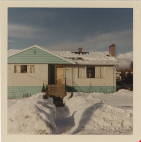
More like 'Allanson family home'
Narrow Results By
Decade
- 2020s 96
- 2010s 44
- 2000s 513
- 1990s 429
- 1980s 412
- 1970s
- 1960s
- 1950s 475
- 1940s 472
- 1930s 427
- 1920s 411
- 1910s 510
- 1900s 184
- 1890s 25
- 1880s 49
- 1870s 3
- 1860s 1
- 1850s 1
- 1840s 1
- 1830s 1
- 1820s 1
- 1810s 1
- 1800s 1
- 1790s 1
- 1780s 1
- 1770s 1
- 1760s 1
- 1750s 1
- 1740s 1
- 1730s 1
- 1720s 1
- 1710s 1
- 1700s 1
- 1690s 1
- 1680s 1
- 1670s 1
- 1660s 1
- 1650s 1
- 1640s 1
- 1630s 1
- 1620s 1
- 1610s 1
- 1600s 1

Arrow Neon Sign
https://search.heritageburnaby.ca/link/landmark861
- Repository
- Burnaby Heritage Planning
- Description
- Commercial building.
- Associated Dates
- 1961
- Other Names
- Lost in the 50's Drive-in
- Street View URL
- Google Maps Street View
- Repository
- Burnaby Heritage Planning
- Other Names
- Lost in the 50's Drive-in
- Geographic Access
- Edmonds Street
- Associated Dates
- 1961
- Description
- Commercial building.
- Heritage Value
- The Arrow Neon Sign was built in 1961 by the Neonette Sign Company of New Westminster when this property was opened as the Tomahawk Drive-in Restaurant. The restaurant was later known as Lindy's Burger and in 1990, the business was renamed Lost in the 50's Drive-in. It stands 20-foot tall and is composed of a large double-sided hollow steel panel serpentine arrow mounted on a pole supporting a lexan sign panel measuring approximately 8 feet wide by 4 feet tall. The sign was designed with three illuminated features: a round lamp at the top of the pole, a double-sided rectangular fluorescent sign panel box, and two double-sided rows of orange neon arrows that follow the large serpentine arrow. The Arrow Neon Sign remains as a rare surviving example of neon sign art in the city and is the only historic neon sign in South Burnaby. The sign has gained prominence over the years as it has been associated with this small iconic drive-in which has also been utilized as a set for film production. Additionally, the drive-in has played a prominent role in the Edmonds community as a popular setting for recent "Show and Shine" participants to park their classic cars.
- Locality
- Edmonds
- Historic Neighbourhood
- East Burnaby (Historic Neighbourhood)
- Planning Study Area
- Lakeview-Mayfield Area
- Builder
- Neonette Sign Company
- Community
- Burnaby
- Contributing Resource
- Structure
- Ownership
- Public (local)
- Street Address
- 7741 Edmonds Street
- Street View URL
- Google Maps Street View
Images


Anderson family home
https://search.heritageburnaby.ca/link/archivedescription37448
- Repository
- City of Burnaby Archives
- Date
- 1962 (date of original), copied 1991
- Collection/Fonds
- Burnaby Historical Society fonds
- Description Level
- Item
- Physical Description
- 1 photograph : b&w ; 4.1 x 3.8 cm print on contact sheet 20.2 x 25.4 cm
- Scope and Content
- Photograph of the front of the Anderson family home at 3908 Norland Avenue (previously numbered 4437 Norland Avenue) in the snow.
- Repository
- City of Burnaby Archives
- Date
- 1962 (date of original), copied 1991
- Collection/Fonds
- Burnaby Historical Society fonds
- Subseries
- Burnaby Image Bank subseries
- Physical Description
- 1 photograph : b&w ; 4.1 x 3.8 cm print on contact sheet 20.2 x 25.4 cm
- Description Level
- Item
- Record No.
- 370-036
- Access Restriction
- No restrictions
- Reproduction Restriction
- No restrictions
- Accession Number
- BHS1999-03
- Scope and Content
- Photograph of the front of the Anderson family home at 3908 Norland Avenue (previously numbered 4437 Norland Avenue) in the snow.
- Media Type
- Photograph
- Notes
- Title based on contents of photograph
- 1 b&w copy negative accompanying
- Geographic Access
- Norland Avenue
- Street Address
- 3908 Norland Avenue
- Historic Neighbourhood
- Burnaby Lake (Historic Neighbourhood)
- Planning Study Area
- Douglas-Gilpin Area
Images

![From 1855 18th Avenue, [1972 or 1973] (date of original), copied 1991 thumbnail](/media/hpo/_Data/_Archives_Images/_Unrestricted/370/370-263.jpg?width=280)
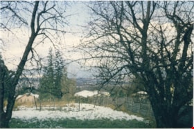
From 1855 18th Avenue
https://search.heritageburnaby.ca/link/archivedescription37675
- Repository
- City of Burnaby Archives
- Date
- [1972 or 1973] (date of original), copied 1991
- Collection/Fonds
- Burnaby Historical Society fonds
- Description Level
- Item
- Physical Description
- 1 photograph : b&w ; 3.9 x 3.9 cm print on contact sheet 20.2 x 25.3 cm
- Scope and Content
- Photograph taken from the front of 1855 18th Avenue (later renumbered as the 7000 block of 18th Avenue), looking north down the street in the snow.
- Repository
- City of Burnaby Archives
- Date
- [1972 or 1973] (date of original), copied 1991
- Collection/Fonds
- Burnaby Historical Society fonds
- Subseries
- Burnaby Image Bank subseries
- Physical Description
- 1 photograph : b&w ; 3.9 x 3.9 cm print on contact sheet 20.2 x 25.3 cm
- Description Level
- Item
- Record No.
- 370-263
- Access Restriction
- No restrictions
- Reproduction Restriction
- No restrictions
- Accession Number
- BHS1999-03
- Scope and Content
- Photograph taken from the front of 1855 18th Avenue (later renumbered as the 7000 block of 18th Avenue), looking north down the street in the snow.
- Media Type
- Photograph
- Notes
- Title based on contents of photograph
- 1 b&w copy negative accompanying
- Negative has a pink cast
- Copied from col. photograph
- Geographic Access
- 18th Avenue
- Historic Neighbourhood
- Edmonds (Historic Neighbourhood)
- Planning Study Area
- Stride Avenue Area
Images
![From 1855 18th Avenue, [1972 or 1973] (date of original), copied 1991 thumbnail](/media/hpo/_Data/_Archives_Images/_Unrestricted/370/370-263.jpg)

Snowfall on Venables Street
https://search.heritageburnaby.ca/link/archivedescription51412
- Repository
- City of Burnaby Archives
- Date
- 1966
- Collection/Fonds
- Harold H. Johnston fonds
- Description Level
- Item
- Physical Description
- 1 photograph (jpeg) : b&w
- Scope and Content
- Photograph taken looking out a window onto Venables Street. The street and automobiles parked along it are covered with snow. The photograph was likely taken from the Johnston family home at 4447 Venables Street.
- Repository
- City of Burnaby Archives
- Date
- 1966
- Collection/Fonds
- Harold H. Johnston fonds
- Physical Description
- 1 photograph (jpeg) : b&w
- Description Level
- Item
- Record No.
- 483-046
- Access Restriction
- No restrictions
- Reproduction Restriction
- No reproduction permitted
- Accession Number
- 2008-08
- Scope and Content
- Photograph taken looking out a window onto Venables Street. The street and automobiles parked along it are covered with snow. The photograph was likely taken from the Johnston family home at 4447 Venables Street.
- Media Type
- Photograph
- Photographer
- Johnston, Harold H.
- Notes
- Title based on contents of photograph
- Geographic Access
- Venables Street
- Street Address
- 4447 Venables Street
- Historic Neighbourhood
- Vancouver Heights (Historic Neighbourhood)
- Planning Study Area
- Willingdon Heights Area
Images


Snow on Venables Street
https://search.heritageburnaby.ca/link/archivedescription51403
- Repository
- City of Burnaby Archives
- Date
- 1965
- Collection/Fonds
- Harold H. Johnston fonds
- Description Level
- Item
- Physical Description
- 1 photograph (jpeg) : b&w
- Scope and Content
- Photograph taken looking over the 4400 block of Venables Street. The ground is covered with snow and two children are standing in the front yard of an unidentified house. The photograph was likely taken at the Johnston family home at 4447 Venables Street and the boy to the left is Sean Johnston whi…
- Repository
- City of Burnaby Archives
- Date
- 1965
- Collection/Fonds
- Harold H. Johnston fonds
- Physical Description
- 1 photograph (jpeg) : b&w
- Description Level
- Item
- Record No.
- 483-037
- Access Restriction
- No restrictions
- Reproduction Restriction
- No reproduction permitted
- Accession Number
- 2008-08
- Scope and Content
- Photograph taken looking over the 4400 block of Venables Street. The ground is covered with snow and two children are standing in the front yard of an unidentified house. The photograph was likely taken at the Johnston family home at 4447 Venables Street and the boy to the left is Sean Johnston while the other child is unidentified.
- Names
- Johnston, Dr. Sean
- Media Type
- Photograph
- Photographer
- Johnston, Harold H.
- Notes
- Title based on contents of photograph
- Geographic Access
- Venables Street
- Street Address
- 4447 Venables Street
- Historic Neighbourhood
- Vancouver Heights (Historic Neighbourhood)
- Planning Study Area
- Willingdon Heights Area
Images


Snow on Venables Street
https://search.heritageburnaby.ca/link/archivedescription51404
- Repository
- City of Burnaby Archives
- Date
- 1965
- Collection/Fonds
- Harold H. Johnston fonds
- Description Level
- Item
- Physical Description
- 1 photograph (jpeg) : b&w
- Scope and Content
- Photograph taken looking over the 4400 block of Venables Street after a snowfall. The photograph was likely taken from the home of Harold Johnston at 4447 Venables Street.
- Repository
- City of Burnaby Archives
- Date
- 1965
- Collection/Fonds
- Harold H. Johnston fonds
- Physical Description
- 1 photograph (jpeg) : b&w
- Description Level
- Item
- Record No.
- 483-038
- Access Restriction
- No restrictions
- Reproduction Restriction
- No reproduction permitted
- Accession Number
- 2008-08
- Scope and Content
- Photograph taken looking over the 4400 block of Venables Street after a snowfall. The photograph was likely taken from the home of Harold Johnston at 4447 Venables Street.
- Media Type
- Photograph
- Photographer
- Johnston, Harold H.
- Notes
- Title based on contents of photograph
- Geographic Access
- Venables Street
- Street Address
- 4447 Venables Street
- Historic Neighbourhood
- Vancouver Heights (Historic Neighbourhood)
- Planning Study Area
- Willingdon Heights Area
Images


Venables Street panorama
https://search.heritageburnaby.ca/link/archivedescription52573
- Repository
- City of Burnaby Archives
- Date
- 1975
- Collection/Fonds
- Harold H. Johnston fonds
- Description Level
- Item
- Physical Description
- 1 photograph (jpeg) : b&w
- Scope and Content
- Photograph is a panorama of Venables Street after a snowfall. The photograph was taken outside of the Johnston family home at 4447 Venables Street (which can be seen at centre).
- Repository
- City of Burnaby Archives
- Date
- 1975
- Collection/Fonds
- Harold H. Johnston fonds
- Physical Description
- 1 photograph (jpeg) : b&w
- Description Level
- Item
- Record No.
- 483-096
- Access Restriction
- No restrictions
- Reproduction Restriction
- No reproduction permitted
- Accession Number
- 2008-08
- Scope and Content
- Photograph is a panorama of Venables Street after a snowfall. The photograph was taken outside of the Johnston family home at 4447 Venables Street (which can be seen at centre).
- Media Type
- Photograph
- Photographer
- Johnston, Harold H.
- Notes
- Title based on contents of photograph
- Geographic Access
- Venables Street
- Street Address
- 4447 Venables Street
- Historic Neighbourhood
- Vancouver Heights (Historic Neighbourhood)
- Planning Study Area
- Willingdon Heights Area
Images

![Corsbie family home on Springer Avenue, [197-] thumbnail](/media/hpo/_Data/_BVM_Images/2020/2020_0031_0026_001.jpg?width=280)
Corsbie family home on Springer Avenue
https://search.heritageburnaby.ca/link/museumdescription20305
- Repository
- Burnaby Village Museum
- Date
- [197-]
- Collection/Fonds
- Joseph H.C. Corsbie fonds
- Description Level
- Item
- Physical Description
- 1 photograph : col. ; 8.5 x 8.5 cm
- Scope and Content
- Photograph of the family home of Joseph (Joe) H. Corsbie and Margaret Corsbie (nee Carr) located at 84 Springer Avenue (North). The Corsbie's lived in this house from 1952 until 1988 and moved to White Rock upon retirement. The front lawn and rooftops tops are covered with snow.
- Repository
- Burnaby Village Museum
- Collection/Fonds
- Joseph H.C. Corsbie fonds
- Description Level
- Item
- Physical Description
- 1 photograph : col. ; 8.5 x 8.5 cm
- Scope and Content
- Photograph of the family home of Joseph (Joe) H. Corsbie and Margaret Corsbie (nee Carr) located at 84 Springer Avenue (North). The Corsbie's lived in this house from 1952 until 1988 and moved to White Rock upon retirement. The front lawn and rooftops tops are covered with snow.
- Geographic Access
- Springer Avenue
- Springer Avenue North
- Street Address
- 84 Springer Avenue
- Accession Code
- BV020.31.26
- Access Restriction
- No restrictions
- Reproduction Restriction
- No known restrictions
- Date
- [197-]
- Media Type
- Photograph
- Scan Resolution
- 600
- Scan Date
- 19-09-2023
- Notes
- Title based on contents of photograph
Images
![Corsbie family home on Springer Avenue, [197-] thumbnail](/media/hpo/_Data/_BVM_Images/2020/2020_0031_0026_001.jpg)

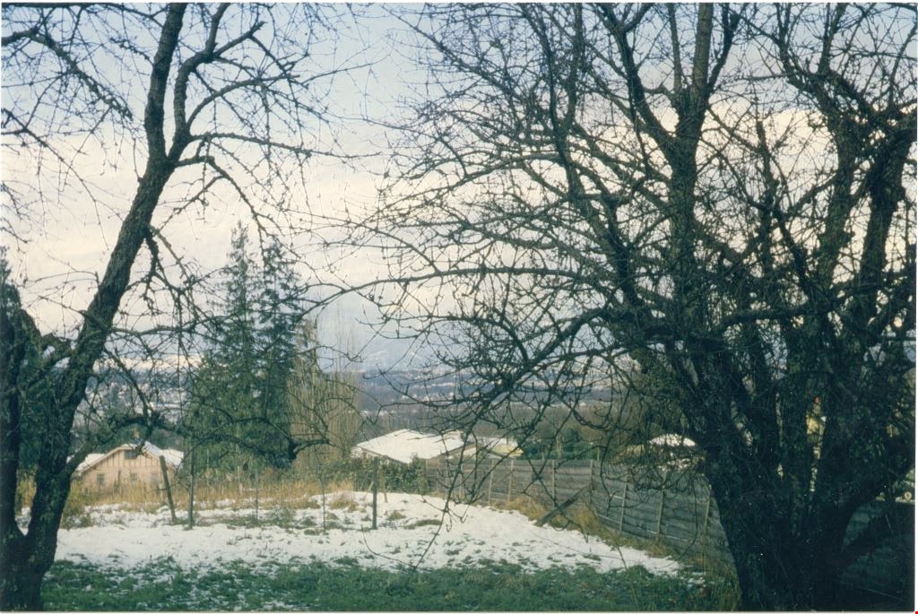
From Linden Avenue and Vista Crescent
https://search.heritageburnaby.ca/link/archivedescription37676
- Repository
- City of Burnaby Archives
- Date
- 1976 (date of original), copied 1991
- Collection/Fonds
- Burnaby Historical Society fonds
- Description Level
- Item
- Physical Description
- 1 photograph : b&w ; 4.1 x 4.0 cm print on contact sheet 20.2 x 25.3 cm
- Scope and Content
- Photograph taken from an apartment balcony after a snowfall at the corner of Linden Avenue and Vista Crescent facing northwest.
- Repository
- City of Burnaby Archives
- Date
- 1976 (date of original), copied 1991
- Collection/Fonds
- Burnaby Historical Society fonds
- Subseries
- Burnaby Image Bank subseries
- Physical Description
- 1 photograph : b&w ; 4.1 x 4.0 cm print on contact sheet 20.2 x 25.3 cm
- Description Level
- Item
- Record No.
- 370-264
- Access Restriction
- No restrictions
- Reproduction Restriction
- No restrictions
- Accession Number
- BHS1999-03
- Scope and Content
- Photograph taken from an apartment balcony after a snowfall at the corner of Linden Avenue and Vista Crescent facing northwest.
- Media Type
- Photograph
- Notes
- Title based on contents of photograph
- 1 b&w copy negative accompanying
- Negative has a pink cast
- Copied from col. photograph
- Geographic Access
- Linden Avenue
- Vista Crescent
- Historic Neighbourhood
- Edmonds (Historic Neighbourhood)
- Planning Study Area
- Richmond Park Area
Images

![Lindsay Johnson at the Lougheed Drive-In Theatre, [1964] (date of original), copied 1991 thumbnail](/media/hpo/_Data/_Archives_Images/_Unrestricted/370/370-477.jpg?width=280)
Lindsay Johnson at the Lougheed Drive-In Theatre
https://search.heritageburnaby.ca/link/archivedescription37889
- Repository
- City of Burnaby Archives
- Date
- [1964] (date of original), copied 1991
- Collection/Fonds
- Burnaby Historical Society fonds
- Description Level
- Item
- Physical Description
- 1 photograph : b&w ; 2.9 x 4.4 cm print on contact sheet 20.4 x 26.9 cm
- Scope and Content
- Photograph of Lindsay Johnson at the Lougheed Drive-In Theatre on the 4200 block of Lougheed Highway at Gilmore Avenue, in the snow.
- Repository
- City of Burnaby Archives
- Date
- [1964] (date of original), copied 1991
- Collection/Fonds
- Burnaby Historical Society fonds
- Subseries
- Burnaby Image Bank subseries
- Physical Description
- 1 photograph : b&w ; 2.9 x 4.4 cm print on contact sheet 20.4 x 26.9 cm
- Description Level
- Item
- Record No.
- 370-477
- Access Restriction
- No restrictions
- Reproduction Restriction
- No restrictions
- Accession Number
- BHS1999-03
- Scope and Content
- Photograph of Lindsay Johnson at the Lougheed Drive-In Theatre on the 4200 block of Lougheed Highway at Gilmore Avenue, in the snow.
- Names
- Johnson, Lindsay
- Media Type
- Photograph
- Notes
- Title based on contents of photograph
- 1 b&w copy negative accompanying
- Negative has a pink cast
- Copied from col. photograph
- Geographic Access
- Lougheed Highway
- Historic Neighbourhood
- Broadview (Historic Neighbourhood)
- Planning Study Area
- West Central Valley Area
Images
![Lindsay Johnson at the Lougheed Drive-In Theatre, [1964] (date of original), copied 1991 thumbnail](/media/hpo/_Data/_Archives_Images/_Unrestricted/370/370-477.jpg)
![Snow at Lougheed Drive-In Theatre, [1964] (date of original), copied 1991 thumbnail](/media/hpo/_Data/_Archives_Images/_Unrestricted/370/370-476.jpg?width=280)
Snow at Lougheed Drive-In Theatre
https://search.heritageburnaby.ca/link/archivedescription37888
- Repository
- City of Burnaby Archives
- Date
- [1964] (date of original), copied 1991
- Collection/Fonds
- Burnaby Historical Society fonds
- Description Level
- Item
- Physical Description
- 1 photograph : b&w ; 2.9 x 4.4 cm print on contact sheet 20.4 x 26.9 cm
- Scope and Content
- Photograph of the Lougheed Drive-In Theatre on the 4200 block of Lougheed Highway at Gilmore Avenue, in the snow. Willmen's Bakery can be seen in the background.
- Repository
- City of Burnaby Archives
- Date
- [1964] (date of original), copied 1991
- Collection/Fonds
- Burnaby Historical Society fonds
- Subseries
- Burnaby Image Bank subseries
- Physical Description
- 1 photograph : b&w ; 2.9 x 4.4 cm print on contact sheet 20.4 x 26.9 cm
- Description Level
- Item
- Record No.
- 370-476
- Access Restriction
- No restrictions
- Reproduction Restriction
- No restrictions
- Accession Number
- BHS1999-03
- Scope and Content
- Photograph of the Lougheed Drive-In Theatre on the 4200 block of Lougheed Highway at Gilmore Avenue, in the snow. Willmen's Bakery can be seen in the background.
- Media Type
- Photograph
- Notes
- Title based on contents of photograph
- 1 b&w copy negative accompanying
- Negative has a pink cast
- Copied from col. photograph
- Geographic Access
- Lougheed Highway
- Historic Neighbourhood
- Broadview (Historic Neighbourhood)
- Planning Study Area
- West Central Valley Area
Images
![Snow at Lougheed Drive-In Theatre, [1964] (date of original), copied 1991 thumbnail](/media/hpo/_Data/_Archives_Images/_Unrestricted/370/370-476.jpg)
![Snow at Lougheed Drive-In Theatre, [1964] (date of original), copied 1991 thumbnail](/media/hpo/_Data/_Archives_Images/_Unrestricted/370/370-478.jpg?width=280)
Snow at Lougheed Drive-In Theatre
https://search.heritageburnaby.ca/link/archivedescription37890
- Repository
- City of Burnaby Archives
- Date
- [1964] (date of original), copied 1991
- Collection/Fonds
- Burnaby Historical Society fonds
- Description Level
- Item
- Physical Description
- 1 photograph : b&w ; 3.0 x 3.0 cm print on contact sheet 20.4 x 26.9 cm
- Scope and Content
- Photograph of the Lougheed Drive-In Theatre on the 4200 block of Lougheed Highway at Gilmore Avenue, in the snow.
- Repository
- City of Burnaby Archives
- Date
- [1964] (date of original), copied 1991
- Collection/Fonds
- Burnaby Historical Society fonds
- Subseries
- Burnaby Image Bank subseries
- Physical Description
- 1 photograph : b&w ; 3.0 x 3.0 cm print on contact sheet 20.4 x 26.9 cm
- Description Level
- Item
- Record No.
- 370-478
- Access Restriction
- No restrictions
- Reproduction Restriction
- No restrictions
- Accession Number
- BHS1999-03
- Scope and Content
- Photograph of the Lougheed Drive-In Theatre on the 4200 block of Lougheed Highway at Gilmore Avenue, in the snow.
- Media Type
- Photograph
- Notes
- Title based on contents of photograph
- 1 b&w copy negative accompanying
- Negative has a pink cast
- Copied from col. photograph
- Geographic Access
- Lougheed Highway
- Historic Neighbourhood
- Broadview (Historic Neighbourhood)
- Planning Study Area
- West Central Valley Area
Images
![Snow at Lougheed Drive-In Theatre, [1964] (date of original), copied 1991 thumbnail](/media/hpo/_Data/_Archives_Images/_Unrestricted/370/370-478.jpg)
![Snow at Lougheed Drive-In Theatre, [1964] (date of original), copied 1991 thumbnail](/media/hpo/_Data/_Archives_Images/_Unrestricted/370/370-479.jpg?width=280)
Snow at Lougheed Drive-In Theatre
https://search.heritageburnaby.ca/link/archivedescription37891
- Repository
- City of Burnaby Archives
- Date
- [1964] (date of original), copied 1991
- Collection/Fonds
- Burnaby Historical Society fonds
- Description Level
- Item
- Physical Description
- 1 photograph : b&w ; 3.0 x 3.0 cm print on contact sheet 20.4 x 26.9 cm
- Scope and Content
- Photograph of the Lougheed Drive-In Theatre on the 4200 block of Lougheed Highway at Gilmore Avenue, in the snow.
- Repository
- City of Burnaby Archives
- Date
- [1964] (date of original), copied 1991
- Collection/Fonds
- Burnaby Historical Society fonds
- Subseries
- Burnaby Image Bank subseries
- Physical Description
- 1 photograph : b&w ; 3.0 x 3.0 cm print on contact sheet 20.4 x 26.9 cm
- Description Level
- Item
- Record No.
- 370-479
- Access Restriction
- No restrictions
- Reproduction Restriction
- No restrictions
- Accession Number
- BHS1999-03
- Scope and Content
- Photograph of the Lougheed Drive-In Theatre on the 4200 block of Lougheed Highway at Gilmore Avenue, in the snow.
- Media Type
- Photograph
- Notes
- Title based on contents of photograph
- 1 b&w copy negative accompanying
- Negative has a pink cast
- Copied from col. photograph
- Geographic Access
- Lougheed Highway
- Historic Neighbourhood
- Broadview (Historic Neighbourhood)
- Planning Study Area
- West Central Valley Area
Images
![Snow at Lougheed Drive-In Theatre, [1964] (date of original), copied 1991 thumbnail](/media/hpo/_Data/_Archives_Images/_Unrestricted/370/370-479.jpg)
![4006 Douglas Road, [1960] (date of original), copied 1991 thumbnail](/media/hpo/_Data/_Archives_Images/_Unrestricted/370/370-516.jpg?width=280)
4006 Douglas Road
https://search.heritageburnaby.ca/link/archivedescription37928
- Repository
- City of Burnaby Archives
- Date
- [1960] (date of original), copied 1991
- Collection/Fonds
- Burnaby Historical Society fonds
- Description Level
- Item
- Physical Description
- 1 photograph : b&w ; 3.1 x 3.1 cm print on contact sheet 20.7 x 26.5 cm
- Scope and Content
- Photograph of 4006 Douglas Road (old numbering) in the snow. The house was located near Douglas Road and Gilpin Street.
- Repository
- City of Burnaby Archives
- Date
- [1960] (date of original), copied 1991
- Collection/Fonds
- Burnaby Historical Society fonds
- Subseries
- Burnaby Image Bank subseries
- Physical Description
- 1 photograph : b&w ; 3.1 x 3.1 cm print on contact sheet 20.7 x 26.5 cm
- Description Level
- Item
- Record No.
- 370-516
- Access Restriction
- No restrictions
- Reproduction Restriction
- No restrictions
- Accession Number
- BHS1999-03
- Scope and Content
- Photograph of 4006 Douglas Road (old numbering) in the snow. The house was located near Douglas Road and Gilpin Street.
- Subjects
- Natural Phenomena - Snow
- Media Type
- Photograph
- Notes
- Title based on contents of photograph
- 1 b&w copy negative accompanying
- Negative has a pink cast
- Geographic Access
- Gilpin Street
- Historic Neighbourhood
- Burnaby Lake (Historic Neighbourhood)
- Planning Study Area
- Douglas-Gilpin Area
Images
![4006 Douglas Road, [1960] (date of original), copied 1991 thumbnail](/media/hpo/_Data/_Archives_Images/_Unrestricted/370/370-516.jpg)
Adell Philips home on Spruce Street
https://search.heritageburnaby.ca/link/museumdescription19092
- Repository
- Burnaby Village Museum
- Date
- 21 Jan. 1969
- Collection/Fonds
- Earl and Adell Philips family fonds
- Description Level
- Item
- Physical Description
- 1 photograph : col. ; 9 x 9 cm
- Scope and Content
- Photograph of Adell Philips' home shortly after she moved in with her son Lea Philips. The house is located at 4085 Spruce Street, Burnaby. The front yard of the house is covered with snow with a shoveled path leading up to the front stairs.
- Repository
- Burnaby Village Museum
- Collection/Fonds
- Earl and Adell Philips family fonds
- Description Level
- Item
- Physical Description
- 1 photograph : col. ; 9 x 9 cm
- Scope and Content
- Photograph of Adell Philips' home shortly after she moved in with her son Lea Philips. The house is located at 4085 Spruce Street, Burnaby. The front yard of the house is covered with snow with a shoveled path leading up to the front stairs.
- Subjects
- Natural Phenomena - Snow
- Geographic Access
- Spruce Street
- Street Address
- 4085 Spruce Street
- Accession Code
- BV022.11.10
- Access Restriction
- No restrictions
- Reproduction Restriction
- No known restrictions
- Date
- 21 Jan. 1969
- Media Type
- Photograph
- Notes
- Title based on contents of photograph
- Note in blue ink on verso of photograph reads: "As it looks when we / moved to 4085 Spruce / Jan 21/69"
- Note in pencil on verso of photograph reads: "#129"
Images

Back yard of the Mervin Mawhinney house looking north west
https://search.heritageburnaby.ca/link/museumdescription5208
- Repository
- Burnaby Village Museum
- Date
- 1962
- Collection/Fonds
- Reverend Edward S. Gale fonds
- Description Level
- Item
- Physical Description
- 1 photograph : col. ; 10 x 15.2 cm print
- Scope and Content
- Photograph of the back yard of the Mervin Mawhinney house looking north west. The ground is covered with snow. Two bare deciduous trees in foreground. The address of the house was 7661 Burris Street and was changed to 7667 Burris Street in 1984.
- Repository
- Burnaby Village Museum
- Collection/Fonds
- Reverend Edward S. Gale fonds
- Description Level
- Item
- Physical Description
- 1 photograph : col. ; 10 x 15.2 cm print
- Scope and Content
- Photograph of the back yard of the Mervin Mawhinney house looking north west. The ground is covered with snow. Two bare deciduous trees in foreground. The address of the house was 7661 Burris Street and was changed to 7667 Burris Street in 1984.
- Subjects
- Natural Phenomena - Snow
- Geographic Access
- Burris Street
- Street Address
- 7667 Burris Street
- Accession Code
- BV018.9.8
- Access Restriction
- No restrictions
- Reproduction Restriction
- May be restricted by third party rights
- Date
- 1962
- Media Type
- Photograph
- Planning Study Area
- Morley-Buckingham Area
- Scan Resolution
- 600
- Scan Date
- 07-05-2018
- Photographer
- Weller, Michael
- Notes
- Title based on contents of photograph
- "Dec. '62 / looking N. west" written in pen on verso.
Images
![Blacksmith shop inside Heritage Village, [between Dec. 1971 and Jan. 1972] thumbnail](/media/hpo/_Data/_BVM_Images//2022/2022_0009_0027_001.jpg?width=280)
Blacksmith shop inside Heritage Village
https://search.heritageburnaby.ca/link/museumdescription18477
- Repository
- Burnaby Village Museum
- Date
- [between Dec. 1971 and Jan. 1972]
- Collection/Fonds
- Century Park Museum Association fonds
- Description Level
- Item
- Physical Description
- 1 photograph : col. slide ; 35 mm
- Scope and Content
- Photograph of the Blacksmith shop inside Heritage Village located at the south end of Hill Street. The ground and rooftop is covered with snow.
- Repository
- Burnaby Village Museum
- Collection/Fonds
- Century Park Museum Association fonds
- Description Level
- Item
- Physical Description
- 1 photograph : col. slide ; 35 mm
- Scope and Content
- Photograph of the Blacksmith shop inside Heritage Village located at the south end of Hill Street. The ground and rooftop is covered with snow.
- Subjects
- Natural Phenomena - Snow
- Names
- Burnaby Village Museum
- Geographic Access
- Deer Lake Avenue
- Accession Code
- BV022.9.27
- Access Restriction
- No restrictions
- Reproduction Restriction
- No known restrictions
- Date
- [between Dec. 1971 and Jan. 1972]
- Media Type
- Photograph
- Photographer
- Lott, Richard
- Notes
- Title based on contents of photograph
Images
![Blacksmith shop inside Heritage Village, [between Dec. 1971 and Jan. 1972] thumbnail](/media/hpo/_Data/_BVM_Images//2022/2022_0009_0027_001.jpg)
![Building on the northwest corner of Hill Street, [between Dec. 1971 and Jan. 1972] thumbnail](/media/hpo/_Data/_BVM_Images//2022/2022_0009_0023_001.jpg?width=280)
Building on the northwest corner of Hill Street
https://search.heritageburnaby.ca/link/museumdescription18472
- Repository
- Burnaby Village Museum
- Date
- [between Dec. 1971 and Jan. 1972]
- Collection/Fonds
- Century Park Museum Association fonds
- Description Level
- Item
- Physical Description
- 1 photograph : col. slide ; 35 mm
- Scope and Content
- Photograph of building on the northwest corner of Hill Street inside Heritage Village. Entrance to the left held the Real Estate Loans and Insurance window display and the entrance to the right held the Jail House window display. The ground and rooftops are covered with snow.
- Repository
- Burnaby Village Museum
- Collection/Fonds
- Century Park Museum Association fonds
- Description Level
- Item
- Physical Description
- 1 photograph : col. slide ; 35 mm
- Scope and Content
- Photograph of building on the northwest corner of Hill Street inside Heritage Village. Entrance to the left held the Real Estate Loans and Insurance window display and the entrance to the right held the Jail House window display. The ground and rooftops are covered with snow.
- Subjects
- Natural Phenomena - Snow
- Names
- Burnaby Village Museum
- Geographic Access
- Deer Lake Avenue
- Accession Code
- BV022.9.23
- Access Restriction
- No restrictions
- Reproduction Restriction
- No known restrictions
- Date
- [between Dec. 1971 and Jan. 1972]
- Media Type
- Photograph
- Photographer
- Lott, Richard
- Notes
- Title based on contents of photograph
Images
![Building on the northwest corner of Hill Street, [between Dec. 1971 and Jan. 1972] thumbnail](/media/hpo/_Data/_BVM_Images//2022/2022_0009_0023_001.jpg)
![Buildings along the east side of Hill Street, [between Dec. 1971 and Jan. 1972] thumbnail](/media/hpo/_Data/_BVM_Images//2022/2022_0009_0021_001.jpg?width=280)
Buildings along the east side of Hill Street
https://search.heritageburnaby.ca/link/museumdescription18470
- Repository
- Burnaby Village Museum
- Date
- [between Dec. 1971 and Jan. 1972]
- Collection/Fonds
- Century Park Museum Association fonds
- Description Level
- Item
- Physical Description
- 1 photograph : col. slide ; 35 mm
- Scope and Content
- Photograph of buildings along the east side of Hill Street on the site of Heritage Village Museum. Buildings left to right include, the Ice Cream Parlour, the Chinese Importers window display, Pharmacy and The News and Art Printing shop. The ground is covered with snow and there is a chain link fen…
- Repository
- Burnaby Village Museum
- Collection/Fonds
- Century Park Museum Association fonds
- Description Level
- Item
- Physical Description
- 1 photograph : col. slide ; 35 mm
- Scope and Content
- Photograph of buildings along the east side of Hill Street on the site of Heritage Village Museum. Buildings left to right include, the Ice Cream Parlour, the Chinese Importers window display, Pharmacy and The News and Art Printing shop. The ground is covered with snow and there is a chain link fence at the end of the street.
- Subjects
- Natural Phenomena - Snow
- Names
- Burnaby Village Museum
- Geographic Access
- Deer Lake Avenue
- Accession Code
- BV022.9.21
- Access Restriction
- No restrictions
- Reproduction Restriction
- No known restrictions
- Date
- [between Dec. 1971 and Jan. 1972]
- Media Type
- Photograph
- Photographer
- Lott, Richard
- Notes
- Title based on contents of photograph
Images
![Buildings along the east side of Hill Street, [between Dec. 1971 and Jan. 1972] thumbnail](/media/hpo/_Data/_BVM_Images//2022/2022_0009_0021_001.jpg)
![Buildings along the west side of Hill Street and Elworth, [between Dec. 1971 and Jan. 1972] thumbnail](/media/hpo/_Data/_BVM_Images//2022/2022_0009_0030_001.jpg?width=280)
Buildings along the west side of Hill Street and Elworth
https://search.heritageburnaby.ca/link/museumdescription18480
- Repository
- Burnaby Village Museum
- Date
- [between Dec. 1971 and Jan. 1972]
- Collection/Fonds
- Century Park Museum Association fonds
- Description Level
- Item
- Physical Description
- 1 photograph : col. slide ; 35 mm
- Scope and Content
- Photograph of buildings located on the west side of Hill Street and Elworth house at the north end of the street inside Heritage Village. Buildings from left to right; the General Supply Store Hardware, Real Estate Loans Insurance building and Elworth house. The ground and rooftops are covered wit…
- Repository
- Burnaby Village Museum
- Collection/Fonds
- Century Park Museum Association fonds
- Description Level
- Item
- Physical Description
- 1 photograph : col. slide ; 35 mm
- Scope and Content
- Photograph of buildings located on the west side of Hill Street and Elworth house at the north end of the street inside Heritage Village. Buildings from left to right; the General Supply Store Hardware, Real Estate Loans Insurance building and Elworth house. The ground and rooftops are covered with snow.
- Subjects
- Natural Phenomena - Snow
- Names
- Burnaby Village Museum
- Geographic Access
- Deer Lake Avenue
- Accession Code
- BV022.9.30
- Access Restriction
- No restrictions
- Reproduction Restriction
- No known restrictions
- Date
- [between Dec. 1971 and Jan. 1972]
- Media Type
- Photograph
- Photographer
- Lott, Richard
- Notes
- Title based on contents of photograph
Images
![Buildings along the west side of Hill Street and Elworth, [between Dec. 1971 and Jan. 1972] thumbnail](/media/hpo/_Data/_BVM_Images//2022/2022_0009_0030_001.jpg)