More like 'Copy of Official British Columbia Road Maps'
Narrow Results By
Subject
- Advertising Medium 2
- Advertising Medium - Signs and Signboards 1
- Aerial Photographs 9
- Agriculture - Farms 3
- Arts - Paintings 1
- Buildings - Civic - Hospitals 2
- Buildings - Commercial 1
- Buildings - Commercial - Hotels and Motels 4
- Buildings - Commercial - Restaurants 1
- Buildings - Heritage 2
- Buildings - Industrial 1
- Buildings - Industrial - Refineries 1
Creator
- Aero Surveys Limited 1
- Bower, Ralph 1
- British Columbia Government Photograph 1
- Campbell Studios Limited 1
- Commercial Illustrators Industrial Photographers 2
- Grant-Mann Lithographers Limited 1
- King, Basil 3
- Lindsay, Jack 4
- National Film Board of Canada 1
- Printed on back of postcard: "Traveltime product. Made in Vancouver, Canada, by Grant-Mann Lithographers, Ltd." 1
- Rossmo, Nicholas 1
- Steffens-Colmer Limited 1
![School room at Oakalla, [195-] (date of original), copied 1991 thumbnail](/media/hpo/_Data/_Archives_Images/_Unrestricted/370/370-733.jpg?width=280)
School room at Oakalla
https://search.heritageburnaby.ca/link/archivedescription38146
- Repository
- City of Burnaby Archives
- Date
- [195-] (date of original), copied 1991
- Collection/Fonds
- Burnaby Historical Society fonds
- Description Level
- Item
- Physical Description
- 1 photograph : b&w ; 3.6 x 4.4 cm print on contact sheet 20.6 x 26.8 cm
- Scope and Content
- Photograph of the interior of a school room at Oakalla Prison Farm. Men are seated at desks, and a student and teacher are at the blackboard standing beside a map. A list of words is on the blackboard.
- Repository
- City of Burnaby Archives
- Date
- [195-] (date of original), copied 1991
- Collection/Fonds
- Burnaby Historical Society fonds
- Subseries
- Burnaby Image Bank subseries
- Physical Description
- 1 photograph : b&w ; 3.6 x 4.4 cm print on contact sheet 20.6 x 26.8 cm
- Description Level
- Item
- Record No.
- 370-733
- Access Restriction
- No restrictions
- Reproduction Restriction
- Reproduce for fair dealing purposes only
- Accession Number
- BHS1999-03
- Scope and Content
- Photograph of the interior of a school room at Oakalla Prison Farm. Men are seated at desks, and a student and teacher are at the blackboard standing beside a map. A list of words is on the blackboard.
- Subjects
- Documentary Artifacts - Maps
- Buildings - Public - Detention Facilities
- Buildings - Schools
- Occupations - Teachers
- Names
- Oakalla Prison Farm
- Media Type
- Photograph
- Notes
- Title based on contents of photograph
- 1 b&w copy negative accompanying
- Negative has a pink cast
- Geographic Access
- Oakmount Crescent
- Street Address
- 5220 Oakmount Crescent
- Historic Neighbourhood
- Burnaby Lake (Historic Neighbourhood)
- Planning Study Area
- Oakalla Area
Images
![School room at Oakalla, [195-] (date of original), copied 1991 thumbnail](/media/hpo/_Data/_Archives_Images/_Unrestricted/370/370-733.jpg)
![North Burnaby, [1959] thumbnail](/media/hpo/_Data/_Archives_Images/_Unrestricted/001/106-001.jpg?width=280)
North Burnaby
https://search.heritageburnaby.ca/link/archivedescription34701
- Repository
- City of Burnaby Archives
- Date
- [1959]
- Collection/Fonds
- Burnaby Historical Society fonds
- Description Level
- Item
- Physical Description
- 1 photograph : b&w ; 16.6 x 20.5 cm
- Scope and Content
- Aerial photograph of North Burnaby and Burrard Inlet looking west.
- Repository
- City of Burnaby Archives
- Date
- [1959]
- Collection/Fonds
- Burnaby Historical Society fonds
- Subseries
- Photographs subseries
- Physical Description
- 1 photograph : b&w ; 16.6 x 20.5 cm
- Description Level
- Item
- Record No.
- 106-001
- Access Restriction
- No restrictions
- Reproduction Restriction
- Reproduce for fair dealing purposes only
- Accession Number
- BHS2007-04
- Scope and Content
- Aerial photograph of North Burnaby and Burrard Inlet looking west.
- Media Type
- Photograph
- Notes
- Title based on contents of photograph
- Historic Neighbourhood
- Vancouver Heights (Historic Neighbourhood)
- Capitol Hill (Historic Neighbourhood)
- Lochdale (Historic Neighbourhood)
- Planning Study Area
- Burnaby Heights Area
- Capitol Hill Area
- Westridge Area
- Willingdon Heights Area
- Brentwood Area
- Parkcrest-Aubrey Area
- Lochdale Area
Images
![North Burnaby, [1959] thumbnail](/media/hpo/_Data/_Archives_Images/_Unrestricted/001/106-001.jpg)
![George Derby Health Centre, [between 1950 and 1954] (date of original), copied 1991 thumbnail](/media/hpo/_Data/_Archives_Images/_Unrestricted/370/370-121.jpg?width=280)
George Derby Health Centre
https://search.heritageburnaby.ca/link/archivedescription37533
- Repository
- City of Burnaby Archives
- Date
- [between 1950 and 1954] (date of original), copied 1991
- Collection/Fonds
- Burnaby Historical Society fonds
- Description Level
- Item
- Physical Description
- 1 photograph : b&w ; 2.5 x 4.1 cm print on contact sheet 20.2 x 25.3 cm
- Scope and Content
- Photograph of the George Derby Health Centre which includes the main building, parking lot and grounds.
- Repository
- City of Burnaby Archives
- Date
- [between 1950 and 1954] (date of original), copied 1991
- Collection/Fonds
- Burnaby Historical Society fonds
- Subseries
- Burnaby Image Bank subseries
- Physical Description
- 1 photograph : b&w ; 2.5 x 4.1 cm print on contact sheet 20.2 x 25.3 cm
- Description Level
- Item
- Record No.
- 370-121
- Access Restriction
- No restrictions
- Reproduction Restriction
- No restrictions
- Accession Number
- BHS1999-03
- Scope and Content
- Photograph of the George Derby Health Centre which includes the main building, parking lot and grounds.
- Subjects
- Geographic Features - Automobile Parking Lots
- Buildings - Civic - Hospitals
- Documentary Artifacts - Postcards
- Media Type
- Photograph
- Notes
- Title based on caption on photograph
- 1 b&w copy negative accompanying
- Print was copied from a postcard original
- Caption at bottom of photograph reads, "George Derby Health Centre / Burnaby B.C."
- Geographic Access
- Cumberland Street
- Street Address
- 7550 Cumberland Street
- Historic Neighbourhood
- East Burnaby (Historic Neighbourhood)
- Planning Study Area
- Cariboo-Armstrong Area
Images
![George Derby Health Centre, [between 1950 and 1954] (date of original), copied 1991 thumbnail](/media/hpo/_Data/_Archives_Images/_Unrestricted/370/370-121.jpg)
![1000 Block Gilley Avenue, [1955] (date of original), copied 1991 thumbnail](/media/hpo/_Data/_Archives_Images/_Unrestricted/370/370-672.jpg?width=280)
1000 Block Gilley Avenue
https://search.heritageburnaby.ca/link/archivedescription38085
- Repository
- City of Burnaby Archives
- Date
- [1955] (date of original), copied 1991
- Collection/Fonds
- Burnaby Historical Society fonds
- Description Level
- Item
- Physical Description
- 1 photograph : b&w ; 3.1 x 3.0 cm print on contact sheet 21.5 x 26.8 cm
- Scope and Content
- Photograph of the 1000 block of Gilley Avenue (later renumbered the 8000 block) looking south towards Marine Drive in the snow.
- Repository
- City of Burnaby Archives
- Date
- [1955] (date of original), copied 1991
- Collection/Fonds
- Burnaby Historical Society fonds
- Subseries
- Burnaby Image Bank subseries
- Physical Description
- 1 photograph : b&w ; 3.1 x 3.0 cm print on contact sheet 21.5 x 26.8 cm
- Description Level
- Item
- Record No.
- 370-672
- Access Restriction
- No restrictions
- Reproduction Restriction
- No restrictions
- Accession Number
- BHS1999-03
- Scope and Content
- Photograph of the 1000 block of Gilley Avenue (later renumbered the 8000 block) looking south towards Marine Drive in the snow.
- Media Type
- Photograph
- Notes
- Title based on contents of photograph
- 1 b&w copy negative accompanying
- Negative has a pink cast
- Geographic Access
- Gilley Avenue
- Planning Study Area
- Clinton-Glenwood Area
- Stride Hill Area
Images
![1000 Block Gilley Avenue, [1955] (date of original), copied 1991 thumbnail](/media/hpo/_Data/_Archives_Images/_Unrestricted/370/370-672.jpg)
![Boundary Road and Kingsway, [1959] thumbnail](/media/Hpo/_Data/_Archives_Images/_Unrestricted/001/113-001.jpg?width=280)
Boundary Road and Kingsway
https://search.heritageburnaby.ca/link/archivedescription34709
- Repository
- City of Burnaby Archives
- Date
- [1959]
- Collection/Fonds
- Burnaby Historical Society fonds
- Description Level
- Item
- Physical Description
- 1 photograph : b&w ; 16.0 x 25.3 cm
- Scope and Content
- Photograph of buildings at Boundary Road and Kingsway, southwest corner. A typed description on the back of the photograph reads, "The new Hemlock (automatic) and old Dexter (manual) exchanges. / B.C. Telephone Company."
- Repository
- City of Burnaby Archives
- Date
- [1959]
- Collection/Fonds
- Burnaby Historical Society fonds
- Subseries
- Photographs subseries
- Physical Description
- 1 photograph : b&w ; 16.0 x 25.3 cm
- Description Level
- Item
- Record No.
- 113-001
- Access Restriction
- No restrictions
- Reproduction Restriction
- Reproduce for fair dealing purposes only
- Accession Number
- BHS2007-04
- Scope and Content
- Photograph of buildings at Boundary Road and Kingsway, southwest corner. A typed description on the back of the photograph reads, "The new Hemlock (automatic) and old Dexter (manual) exchanges. / B.C. Telephone Company."
- Media Type
- Photograph
- Photographer
- Williams Brothers Photographers Limited
- Notes
- Title based on contents of photograph
- Stamp on back of photograph reads, "Williams Bros. Photographers Ltd. / 413 Granville St. Vancouver 2, B.C. / Phone Tatlow 8588"
- Geographic Access
- Boundary Road
- Kingsway
- Historic Neighbourhood
- Central Park (Historic Neighbourhood)
- Planning Study Area
- Garden Village Area
Images
![Boundary Road and Kingsway, [1959] thumbnail](/media/Hpo/_Data/_Archives_Images/_Unrestricted/001/113-001.jpg)
![Freeway at the Willingdon Avenue exit, [1955] thumbnail](/media/hpo/_Data/_Archives_Images/_Unrestricted/480/480-283.jpg?width=280)
Freeway at the Willingdon Avenue exit
https://search.heritageburnaby.ca/link/archivedescription45388
- Repository
- City of Burnaby Archives
- Date
- [1955]
- Collection/Fonds
- Columbian Newspaper collection
- Description Level
- Item
- Physical Description
- 1 photograph : b&w ; 20 x 24.5 cm
- Scope and Content
- Photograph of the Freeway, now named the Trans Canada Highway, near the Willingdon Avenue exit.
- Repository
- City of Burnaby Archives
- Date
- [1955]
- Collection/Fonds
- Columbian Newspaper collection
- Physical Description
- 1 photograph : b&w ; 20 x 24.5 cm
- Description Level
- Item
- Record No.
- 480-283
- Access Restriction
- No restrictions
- Reproduction Restriction
- No restrictions
- Accession Number
- 2003-02
- Scope and Content
- Photograph of the Freeway, now named the Trans Canada Highway, near the Willingdon Avenue exit.
- Subjects
- Geographic Features - Roads
- Media Type
- Photograph
- Photographer
- British Columbia Government Photograph
- Notes
- Title based on contents of photograph
- Photographer identifies photograph as no. H - 1869
- Geographic Access
- Trans Canada Highway
- Willingdon Avenue
- Historic Neighbourhood
- Broadview (Historic Neighbourhood)
- Planning Study Area
- Cascade-Schou Area
Images
![Freeway at the Willingdon Avenue exit, [1955] thumbnail](/media/hpo/_Data/_Archives_Images/_Unrestricted/480/480-283.jpg)

New Freeway in Burnaby
https://search.heritageburnaby.ca/link/archivedescription45383
- Repository
- City of Burnaby Archives
- Date
- 1959
- Collection/Fonds
- Columbian Newspaper collection
- Description Level
- Item
- Physical Description
- 1 photograph : b&w ; 20.5 x 18.5 cm
- Scope and Content
- Photograph of the Lower mainland's "new freeway" in Burnaby. This was taken along the Trans Canada Highway with the Willingdon exit off to the south and the Grandview Highway off to the west.
- Repository
- City of Burnaby Archives
- Date
- 1959
- Collection/Fonds
- Columbian Newspaper collection
- Physical Description
- 1 photograph : b&w ; 20.5 x 18.5 cm
- Description Level
- Item
- Record No.
- 480-278
- Access Restriction
- No restrictions
- Reproduction Restriction
- No restrictions
- Accession Number
- 2003-02
- Scope and Content
- Photograph of the Lower mainland's "new freeway" in Burnaby. This was taken along the Trans Canada Highway with the Willingdon exit off to the south and the Grandview Highway off to the west.
- Subjects
- Geographic Features - Roads
- Media Type
- Photograph
- Photographer
- King, Basil
- Notes
- Title based on note on verso of photograph
- Note on verso of photograph reads: "Lower mainland's new freeway in Burnaby"
- Geographic Access
- Trans Canada Highway
- Historic Neighbourhood
- Broadview (Historic Neighbourhood)
- Planning Study Area
- Cascade-Schou Area
Images

![New Vista Society Housing Projects, [between 1949 and 1957] thumbnail](/media/hpo/_Data/_Archives_Images/_Unrestricted/513/514-013.jpg?width=280)
New Vista Society Housing Projects
https://search.heritageburnaby.ca/link/archivedescription64687
- Repository
- City of Burnaby Archives
- Date
- [between 1949 and 1957]
- Collection/Fonds
- Ernest Winch fonds
- Description Level
- Item
- Physical Description
- 1 photograph : b&w postcard ; 8 x 13 cm
- Scope and Content
- Photographic postcard of an unpaved road lined with New Vista Society Housing Projects.
- Repository
- City of Burnaby Archives
- Date
- [between 1949 and 1957]
- Collection/Fonds
- Ernest Winch fonds
- Physical Description
- 1 photograph : b&w postcard ; 8 x 13 cm
- Description Level
- Item
- Record No.
- 514-013
- Access Restriction
- No restrictions
- Reproduction Restriction
- Reproduce for fair dealing purposes only
- Accession Number
- 2010-06
- Scope and Content
- Photographic postcard of an unpaved road lined with New Vista Society Housing Projects.
- Names
- New Vista Society
- Media Type
- Photograph
- Notes
- Title based on contents of photograph
- Handwritten in border of photograph: "1-2-3"
Images
![New Vista Society Housing Projects, [between 1949 and 1957] thumbnail](/media/hpo/_Data/_Archives_Images/_Unrestricted/513/514-013.jpg)
![Overpass, [195-] (date of original), copied 1976 thumbnail](/media/hpo/_Data/_BVM_Images/1974/197602510029.jpg?width=280)
Overpass
https://search.heritageburnaby.ca/link/museumdescription1624
- Repository
- Burnaby Village Museum
- Date
- [195-] (date of original), copied 1976
- Collection/Fonds
- Burnaby Village Museum Photograph collection
- Description Level
- Item
- Physical Description
- 1 photograph : col. negative ; 4.5 x 6.5 cm
- Scope and Content
- Photograph of a newly constructed overpass, with a roadway below prepared for construction. An unidentified man is standing on the right side. The location is unidentified, but it is likely that the photograph was taken in Burnaby.
- Repository
- Burnaby Village Museum
- Collection/Fonds
- Burnaby Village Museum Photograph collection
- Description Level
- Item
- Physical Description
- 1 photograph : col. negative ; 4.5 x 6.5 cm
- Scope and Content
- Photograph of a newly constructed overpass, with a roadway below prepared for construction. An unidentified man is standing on the right side. The location is unidentified, but it is likely that the photograph was taken in Burnaby.
- Accession Code
- HV976.251.29
- Access Restriction
- No restrictions
- Reproduction Restriction
- May be restricted by third party rights
- Date
- [195-] (date of original), copied 1976
- Media Type
- Photograph
- Scan Resolution
- 300
- Scan Date
- 22/8/2006
- Scale
- 100
- Notes
- Title based on contents of photograph
- The print is made as a black and white print from a colour negative film
Images
![Overpass, [195-] (date of original), copied 1976 thumbnail](/media/hpo/_Data/_BVM_Images/1974/197602510029.jpg)
![Street clearing, [195-] (date of original), copied 1976 thumbnail](/media/hpo/_Data/_BVM_Images/1974/197602510027.jpg?width=280)
Street clearing
https://search.heritageburnaby.ca/link/museumdescription1622
- Repository
- Burnaby Village Museum
- Date
- [195-] (date of original), copied 1976
- Collection/Fonds
- Burnaby Village Museum Photograph collection
- Description Level
- Item
- Physical Description
- 1 photograph : col. negative ; 4.5 x 6.5 cm
- Scope and Content
- Photograph of the Grandview ramp off of the Trans Canada Highway in Burnaby that is cleared, possibly in preparation for the highway. The clearing for the street is several lanes wide, and in the distance, an overpass bridge can be seen. There are houses and along both sides of the cleared street.
- Repository
- Burnaby Village Museum
- Collection/Fonds
- Burnaby Village Museum Photograph collection
- Description Level
- Item
- Physical Description
- 1 photograph : col. negative ; 4.5 x 6.5 cm
- Scope and Content
- Photograph of the Grandview ramp off of the Trans Canada Highway in Burnaby that is cleared, possibly in preparation for the highway. The clearing for the street is several lanes wide, and in the distance, an overpass bridge can be seen. There are houses and along both sides of the cleared street.
- Accession Code
- HV976.251.27
- Access Restriction
- No restrictions
- Reproduction Restriction
- May be restricted by third party rights
- Date
- [195-] (date of original), copied 1976
- Media Type
- Photograph
- Scan Resolution
- 300
- Scan Date
- 22/8/2006
- Scale
- 100
- Notes
- Title based on contents of photograph
- The print is made as a black and white print from a colour negative film
Images
![Street clearing, [195-] (date of original), copied 1976 thumbnail](/media/hpo/_Data/_BVM_Images/1974/197602510027.jpg)
![Two lane tunnel, [between 1947 and 1957] thumbnail](/media/hpo/_Data/_BVM_Images/2022/2022_0032_0569_001.jpg?width=280)
Two lane tunnel
https://search.heritageburnaby.ca/link/museumdescription20147
- Repository
- Burnaby Village Museum
- Date
- [between 1947 and 1957]
- Collection/Fonds
- Esther Love Stanley fonds
- Description Level
- Item
- Physical Description
- 1 photograph : b&w ; 6 x 9 cm
- Scope and Content
- Photograph of a two lane tunnel on an unidentified roadway. A garden with flowers is between the two tunnel openings.
- Repository
- Burnaby Village Museum
- Collection/Fonds
- Esther Love Stanley fonds
- Description Level
- Item
- Physical Description
- 1 photograph : b&w ; 6 x 9 cm
- Scope and Content
- Photograph of a two lane tunnel on an unidentified roadway. A garden with flowers is between the two tunnel openings.
- Subjects
- Structures
- Geographic Features - Roads
- Accession Code
- BV022.32.569
- Access Restriction
- No restrictions
- Reproduction Restriction
- No known restrictions
- Date
- [between 1947 and 1957]
- Media Type
- Photograph
- Scan Resolution
- 600
- Scan Date
- 2023-09-04
- Notes
- Title based on contents of photograph
- Photograph is part of Esther Love Stanley photograph album 2 (BV032.22.431)
Images
![Two lane tunnel, [between 1947 and 1957] thumbnail](/media/hpo/_Data/_BVM_Images/2022/2022_0032_0569_001.jpg)
![Valerie and Dorothy Shantz, [1956] (date of original), copied 1991 thumbnail](/media/hpo/_Data/_Archives_Images/_Unrestricted/370/370-178.jpg?width=280)
Valerie and Dorothy Shantz
https://search.heritageburnaby.ca/link/archivedescription37590
- Repository
- City of Burnaby Archives
- Date
- [1956] (date of original), copied 1991
- Collection/Fonds
- Burnaby Historical Society fonds
- Description Level
- Item
- Physical Description
- 1 photograph : b&w ; 4.6 x 3.1 cm print on contact sheet 20.2 x 25.3 cm
- Scope and Content
- Photograph of Dorothy Shantz holding her daughter, Valerie Shantz. The photograph was taken looking east along Albert Street at Madison Avenue. Capitol Hill is visible in the background.
- Repository
- City of Burnaby Archives
- Date
- [1956] (date of original), copied 1991
- Collection/Fonds
- Burnaby Historical Society fonds
- Subseries
- Burnaby Image Bank subseries
- Physical Description
- 1 photograph : b&w ; 4.6 x 3.1 cm print on contact sheet 20.2 x 25.3 cm
- Description Level
- Item
- Record No.
- 370-178
- Access Restriction
- No restrictions
- Reproduction Restriction
- No restrictions
- Accession Number
- BHS1999-03
- Scope and Content
- Photograph of Dorothy Shantz holding her daughter, Valerie Shantz. The photograph was taken looking east along Albert Street at Madison Avenue. Capitol Hill is visible in the background.
- Subjects
- Geographic Features - Roads
- Media Type
- Photograph
- Notes
- Title based on contents of photograph
- 2 b&w copy prints accompanying
- 1 b&w copy negative accompanying
- Negative has a pink cast
- Geographic Access
- Albert Street
- Madison Avenue
- Historic Neighbourhood
- Vancouver Heights (Historic Neighbourhood)
- Planning Study Area
- Burnaby Heights Area
Images
![Valerie and Dorothy Shantz, [1956] (date of original), copied 1991 thumbnail](/media/hpo/_Data/_Archives_Images/_Unrestricted/370/370-178.jpg)
![Walking to June Ickringills house, [1957 or 1958] thumbnail](/media/hpo/_Data/_Archives_Images/_Unrestricted/205/246-011.jpg?width=280)
Walking to June Ickringills house
https://search.heritageburnaby.ca/link/archivedescription52971
- Repository
- City of Burnaby Archives
- Date
- [1957 or 1958]
- Collection/Fonds
- Burnaby Historical Society fonds
- Description Level
- Item
- Physical Description
- 1 photograph : b&w ; 7 x 10 cm, mounted on heavy-weight paper 17.5 x 27.5 cm
- Scope and Content
- Photograph of four kindergartners walking along a gravel sidewalk, along a gravel road to June Ickringills house. The girl in front is wearing a plaid dress, and the three boys behind her are wearing short pants and short-sleeve dress shirts. There is a woman in a white dress walking on the other s…
- Repository
- City of Burnaby Archives
- Date
- [1957 or 1958]
- Collection/Fonds
- Burnaby Historical Society fonds
- Subseries
- Tinkerbell Kindergarten subseries
- Physical Description
- 1 photograph : b&w ; 7 x 10 cm, mounted on heavy-weight paper 17.5 x 27.5 cm
- Description Level
- Item
- Record No.
- 246-011
- Access Restriction
- No restrictions
- Reproduction Restriction
- Reproduce for fair dealing purposes only
- Accession Number
- BHS1990-12
- Scope and Content
- Photograph of four kindergartners walking along a gravel sidewalk, along a gravel road to June Ickringills house. The girl in front is wearing a plaid dress, and the three boys behind her are wearing short pants and short-sleeve dress shirts. There is a woman in a white dress walking on the other side of the street, in front of a house with a white picket fence.
- Media Type
- Photograph
- Notes
- Title based on contents of photograph
- Handwritten note on paper mount reads: "Visit to June Ickringill's Home 1957-1958"
Images
![Walking to June Ickringills house, [1957 or 1958] thumbnail](/media/hpo/_Data/_Archives_Images/_Unrestricted/205/246-011.jpg)
![Westlawn Drive, [1953] thumbnail](/media/hpo/_Data/_Archives_Images/_Unrestricted/371/401-001.jpg?width=280)
Westlawn Drive
https://search.heritageburnaby.ca/link/archivedescription38304
- Repository
- City of Burnaby Archives
- Date
- [1953]
- Collection/Fonds
- Burnaby Historical Society fonds
- Description Level
- Item
- Physical Description
- 1 photograph : b&w ; 20.3 x 24.8 cm
- Scope and Content
- Photograph of Westlawn Drive, in the Brentwood area, under construction. A number of houses can be seen in various stages of construction and the road is unpaved.
- Repository
- City of Burnaby Archives
- Date
- [1953]
- Collection/Fonds
- Burnaby Historical Society fonds
- Subseries
- Jim Wolf subseries
- Physical Description
- 1 photograph : b&w ; 20.3 x 24.8 cm
- Description Level
- Item
- Record No.
- 401-001
- Access Restriction
- No restrictions
- Reproduction Restriction
- Reproduce for fair dealing purposes only
- Accession Number
- BHS2000-11
- Scope and Content
- Photograph of Westlawn Drive, in the Brentwood area, under construction. A number of houses can be seen in various stages of construction and the road is unpaved.
- Subjects
- Construction
- Geographic Features - Roads
- Media Type
- Photograph
- Notes
- Title based on contents of photograph.
- Geographic Access
- Westlawn Drive
- Planning Study Area
- Brentwood Area
Images
![Westlawn Drive, [1953] thumbnail](/media/hpo/_Data/_Archives_Images/_Unrestricted/371/401-001.jpg)
![Burnaby Mountain, [between 1958 and 1965] (date of original), copied 1991 thumbnail](/media/hpo/_Data/_Archives_Images/_Unrestricted/370/370-797.jpg?width=280)
Burnaby Mountain
https://search.heritageburnaby.ca/link/archivedescription38210
- Repository
- City of Burnaby Archives
- Date
- [between 1958 and 1965] (date of original), copied 1991
- Collection/Fonds
- Burnaby Historical Society fonds
- Description Level
- Item
- Physical Description
- 1 photograph : b&w ; 3.2 x 5.1 cm print on contact sheet 20.5 x 26.8 cm
- Scope and Content
- Aerial photograph of Centennial Park, Burnaby Mountain and Burrard Inlet looking east.
- Repository
- City of Burnaby Archives
- Date
- [between 1958 and 1965] (date of original), copied 1991
- Collection/Fonds
- Burnaby Historical Society fonds
- Subseries
- Burnaby Image Bank subseries
- Physical Description
- 1 photograph : b&w ; 3.2 x 5.1 cm print on contact sheet 20.5 x 26.8 cm
- Description Level
- Item
- Record No.
- 370-797
- Access Restriction
- No restrictions
- Reproduction Restriction
- No restrictions
- Accession Number
- BHS1999-03
- Scope and Content
- Aerial photograph of Centennial Park, Burnaby Mountain and Burrard Inlet looking east.
- Subjects
- Aerial Photographs
- Geographic Features - Inlets
- Geographic Features - Mountains
- Geographic Features - Parks
- Media Type
- Photograph
- Notes
- Title based on contents of photograph
- 1 b&w copy negative accompanying
- Geographic Access
- Burnaby Mountain Conservation Area
- Planning Study Area
- Burnaby Mountain Area
Images
![Burnaby Mountain, [between 1958 and 1965] (date of original), copied 1991 thumbnail](/media/hpo/_Data/_Archives_Images/_Unrestricted/370/370-797.jpg)
Personal material
https://search.heritageburnaby.ca/link/archivedescription82732
- Repository
- City of Burnaby Archives
- Date
- [1910-1978]
- Collection/Fonds
- Hazel Simnett collection
- Description Level
- File
- Physical Description
- 9 paintings : colour print, 2 photographs : b&w, and 1 folder of textual records
- Scope and Content
- File consists of application for a driver's license, Kingsway Driving School report card, driver's examination receipt and a letter addressed to Hazel Simnett from the Victorian Order of Nurses for Canada. Also included is an immigration inspection card of Fred Simnett aboard the S.S. Lake Champlai…
- Repository
- City of Burnaby Archives
- Date
- [1910-1978]
- Collection/Fonds
- Hazel Simnett collection
- Physical Description
- 9 paintings : colour print, 2 photographs : b&w, and 1 folder of textual records
- Description Level
- File
- Record No.
- MSS167-008
- Accession Number
- 2013-22
- Scope and Content
- File consists of application for a driver's license, Kingsway Driving School report card, driver's examination receipt and a letter addressed to Hazel Simnett from the Victorian Order of Nurses for Canada. Also included is an immigration inspection card of Fred Simnett aboard the S.S. Lake Champlain from Liverpool and a letter from the Office of the Mayor addressed to Mary Ann Simnett for her ninetieth birthday. Also included is a photograph (see item 559-001). Also included are newsclippings regarding Robert Burnaby and the "Bygones of Burnaby" book, a programme of the Robert Burnaby Commemorative Dinner, a photocopy of "The Argus" (Burnaby South High School's newspaper) from 1938, a programme from Madys Pridmore Brown's Variety Programme, "The Buzzer" Volume 40 Issue 16 advertising Vancouver street cars, New Vista Society certificate addressed to Hazel Simnett, an envelope of Fenwick Lansdowne bird prints from 1957 and a print of the Royal Family found in a cardboard envelope postmarked 1972.
- Subjects
- Arts - Paintings
- Documentary Artifacts - Newspapers
- Documentary Artifacts - Photographs
- Performances - Concerts
- Organizations - Societies and Clubs
- Personal Symbols - Certificates
- Transportation
- Persons - Royalty
- Media Type
- Textual Record
- Photograph
- Graphic Material
- Notes
- Title based on note accompanying file on folder ; The Argue was stapled together
- Simnett personal papers series
- Historic Neighbourhood
- Alta-Vista (Historic Neighbourhood)
- Planning Study Area
- Clinton-Glenwood Area

From 4042 Yale Street
https://search.heritageburnaby.ca/link/archivedescription37628
- Repository
- City of Burnaby Archives
- Date
- 1952 (date of original), copied 1991
- Collection/Fonds
- Burnaby Historical Society fonds
- Description Level
- Item
- Physical Description
- 1 photograph : b&w ; 2.9 x 4.8 cm print on contact sheet 20.2 x 25.3 cm
- Scope and Content
- Photograph taken looking north from 4042 Yale Street. Burrard Inlet and the northshore mountains are visible in the background, and there is snow.
- Repository
- City of Burnaby Archives
- Date
- 1952 (date of original), copied 1991
- Collection/Fonds
- Burnaby Historical Society fonds
- Subseries
- Burnaby Image Bank subseries
- Physical Description
- 1 photograph : b&w ; 2.9 x 4.8 cm print on contact sheet 20.2 x 25.3 cm
- Description Level
- Item
- Record No.
- 370-216
- Access Restriction
- No restrictions
- Reproduction Restriction
- No restrictions
- Accession Number
- BHS1999-03
- Scope and Content
- Photograph taken looking north from 4042 Yale Street. Burrard Inlet and the northshore mountains are visible in the background, and there is snow.
- Subjects
- Buildings - Residential - Houses
- Geographic Features - Inlets
- Geographic Features - Mountains
- Media Type
- Photograph
- Notes
- Title based on contents of photograph
- 1 b&w copy negative accompanying
- Geographic Access
- Yale Street
- Street Address
- 4042 Yale Street
- Historic Neighbourhood
- Vancouver Heights (Historic Neighbourhood)
- Planning Study Area
- Burnaby Heights Area
Images


View from Kask's Camp
https://search.heritageburnaby.ca/link/archivedescription35531
- Repository
- City of Burnaby Archives
- Date
- 1950 (date of original), copied 1986
- Collection/Fonds
- Burnaby Historical Society fonds
- Description Level
- Item
- Physical Description
- 1 photograph : b&w ; 12.7 x 17.8 cm print
- Scope and Content
- Photograph of top of the hill moved by William Kask, Sr. at the request of Jenny Korhonen Kask who wanted a better view of Burrard Inlet and the islands from her house in Kask's Camp, later Kask Bros. Cement Works. Mr. Kask had the top of the mountain shave off with a bulldozer. A Vancouver Sun h…
- Repository
- City of Burnaby Archives
- Date
- 1950 (date of original), copied 1986
- Collection/Fonds
- Burnaby Historical Society fonds
- Subseries
- Pioneer Tales subseries
- Physical Description
- 1 photograph : b&w ; 12.7 x 17.8 cm print
- Description Level
- Item
- Record No.
- 204-389
- Access Restriction
- No restrictions
- Reproduction Restriction
- Reproduce for fair dealing purposes only
- Accession Number
- BHS1988-03
- Scope and Content
- Photograph of top of the hill moved by William Kask, Sr. at the request of Jenny Korhonen Kask who wanted a better view of Burrard Inlet and the islands from her house in Kask's Camp, later Kask Bros. Cement Works. Mr. Kask had the top of the mountain shave off with a bulldozer. A Vancouver Sun headline read, "Man Moves Mountain."
- Media Type
- Photograph
- Notes
- Title based on contents of photograph
- Geographic Access
- Barnet Road
- Street Address
- 7501 Barnet Road
- Historic Neighbourhood
- Barnet (Historic Neighbourhood)
- Planning Study Area
- Burnaby Mountain Area
Images

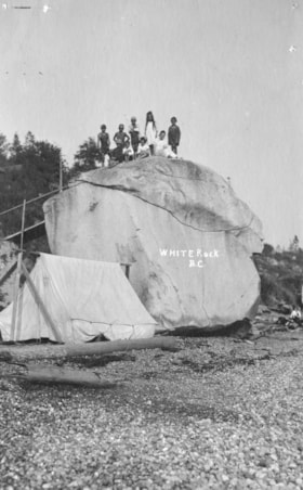
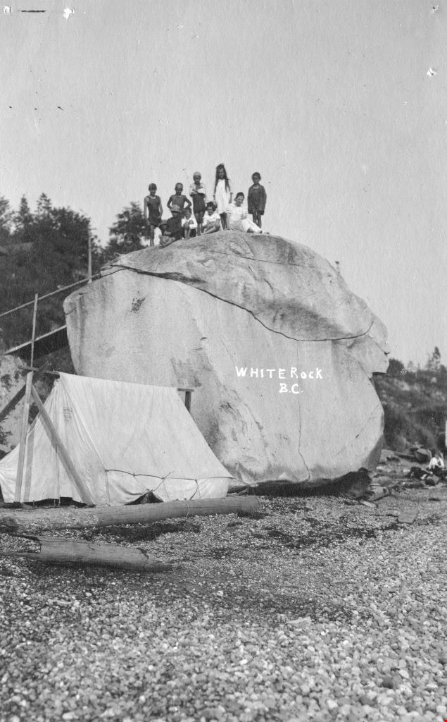
White Rock B.C.
https://search.heritageburnaby.ca/link/archivedescription64697
- Repository
- City of Burnaby Archives
- Date
- September 19, 1956
- Collection/Fonds
- Ernest Winch fonds
- Description Level
- Item
- Physical Description
- 1 photograph : sepia postcard ; 13.5 x 8.5 cm
- Scope and Content
- Photographic postcard of a group of unidentified children standing together on top of the large white rock on the beach at White Rock, B.C.
- Repository
- City of Burnaby Archives
- Date
- September 19, 1956
- Collection/Fonds
- Ernest Winch fonds
- Physical Description
- 1 photograph : sepia postcard ; 13.5 x 8.5 cm
- Description Level
- Item
- Record No.
- 514-020
- Access Restriction
- No restrictions
- Reproduction Restriction
- Reproduce for fair dealing purposes only
- Accession Number
- 2010-06
- Scope and Content
- Photographic postcard of a group of unidentified children standing together on top of the large white rock on the beach at White Rock, B.C.
- Media Type
- Photograph
- Notes
- Handwritten note in white ink on recto of photograph reads: "WHITE ROCK / B.C."
- Handwritten note in pencil on verso of photographic postcard reads: "children taken / on White Rock"
Images

The Benedictines of Westminster Priory
https://search.heritageburnaby.ca/link/archivedescription38167
- Repository
- City of Burnaby Archives
- Date
- 1951 (date of original), copied 1991
- Collection/Fonds
- Burnaby Historical Society fonds
- Description Level
- Item
- Physical Description
- 1 photograph : b&w ; 3.3 x 5.3 cm print on contact sheet 20.1 x 26.3 cm
- Scope and Content
- Photograph of an original photographic postcard of the Benedictines of Westminster Priory at Ceperley House which was funded by the Catholic Diocese beginning in 1939. There is a postmark from Merritt, British Columbia, at the top right corner.
- Repository
- City of Burnaby Archives
- Date
- 1951 (date of original), copied 1991
- Collection/Fonds
- Burnaby Historical Society fonds
- Subseries
- Burnaby Image Bank subseries
- Physical Description
- 1 photograph : b&w ; 3.3 x 5.3 cm print on contact sheet 20.1 x 26.3 cm
- Description Level
- Item
- Record No.
- 370-754
- Access Restriction
- No restrictions
- Reproduction Restriction
- No restrictions
- Accession Number
- BHS1999-03
- Scope and Content
- Photograph of an original photographic postcard of the Benedictines of Westminster Priory at Ceperley House which was funded by the Catholic Diocese beginning in 1939. There is a postmark from Merritt, British Columbia, at the top right corner.
- Subjects
- Buildings - Religious
- Buildings - Heritage
- Occupations - Clergy
- Documentary Artifacts - Postcards
- Names
- Westminster Priory
- Media Type
- Photograph
- Notes
- 1 b&w copy negative accompanying
- Negative has a pink cast
- Annotation at bottom of photograph reads, "The Benedictines of Westminster Priory, Vancouver, BC"
- Geographic Access
- Deer Lake Avenue
- Street Address
- 6344 Deer Lake Avenue
- Historic Neighbourhood
- Burnaby Lake (Historic Neighbourhood)
- Planning Study Area
- Douglas-Gilpin Area
Images
