More like '5899 Wilson Ave.'
Narrow Results By
Decade
- 2020s 87
- 2010s 43
- 2000s 495
- 1990s 413
- 1980s 399
- 1970s 807
- 1960s 288
- 1950s
- 1940s 464
- 1930s 360
- 1920s 427
- 1910s 488
- 1900s 181
- 1890s 24
- 1880s 49
- 1870s 3
- 1860s 1
- 1850s 1
- 1840s 1
- 1830s 1
- 1820s 1
- 1810s 1
- 1800s 1
- 1790s 1
- 1780s 1
- 1770s 1
- 1760s 1
- 1750s 1
- 1740s 1
- 1730s 1
- 1720s 1
- 1710s 1
- 1700s 1
- 1690s 1
- 1680s 1
- 1670s 1
- 1660s 1
- 1650s 1
- 1640s 1
- 1630s 1
- 1620s 1
- 1610s 1
- 1600s 1
Subject
- Advertising Medium 2
- Advertising Medium - Signs and Signboards 7
- Aerial Photographs 8
- Agriculture - Farms 17
- Agriculture - Fruit and Berries 1
- Animals - Horses 1
- Arts - Paintings 1
- Buildings 2
- Buildings - Agricultural 1
- Buildings - Agricultural - Barns 6
- Buildings - Agricultural - Greenhouses 5
- Buildings - Agricultural - Nurseries 1

4297 Albert Street
https://search.heritageburnaby.ca/link/archivedescription37591
- Repository
- City of Burnaby Archives
- Date
- 1951 (date of original), copied 1991
- Collection/Fonds
- Burnaby Historical Society fonds
- Description Level
- Item
- Physical Description
- 1 photograph : b&w ; 2.7 x 4.2 cm print on contact sheet 20.2 x 25.3 cm
- Scope and Content
- Photograph of 4297 Albert Street. Another house is visible in the background.
- Repository
- City of Burnaby Archives
- Date
- 1951 (date of original), copied 1991
- Collection/Fonds
- Burnaby Historical Society fonds
- Subseries
- Burnaby Image Bank subseries
- Physical Description
- 1 photograph : b&w ; 2.7 x 4.2 cm print on contact sheet 20.2 x 25.3 cm
- Description Level
- Item
- Record No.
- 370-179
- Access Restriction
- No restrictions
- Reproduction Restriction
- No restrictions
- Accession Number
- BHS1999-03
- Scope and Content
- Photograph of 4297 Albert Street. Another house is visible in the background.
- Subjects
- Buildings - Residential - Houses
- Media Type
- Photograph
- Notes
- Title based on contents of photograph
- 1 b&w copy negative accompanying
- Negative has a pink cast
- Geographic Access
- Albert Street
- Street Address
- 4297 Albert Street
- Historic Neighbourhood
- Vancouver Heights (Historic Neighbourhood)
- Planning Study Area
- Burnaby Heights Area
Images


4297 Albert Street
https://search.heritageburnaby.ca/link/archivedescription37592
- Repository
- City of Burnaby Archives
- Date
- 1950 (date of original), copied 1991
- Collection/Fonds
- Burnaby Historical Society fonds
- Description Level
- Item
- Physical Description
- 1 photograph : b&w ; 3.4 x 3.5 cm print on contact sheet 20.2 x 25.3 cm
- Scope and Content
- Photograph of 4297 Albert Street.
- Repository
- City of Burnaby Archives
- Date
- 1950 (date of original), copied 1991
- Collection/Fonds
- Burnaby Historical Society fonds
- Subseries
- Burnaby Image Bank subseries
- Physical Description
- 1 photograph : b&w ; 3.4 x 3.5 cm print on contact sheet 20.2 x 25.3 cm
- Description Level
- Item
- Record No.
- 370-180
- Access Restriction
- No restrictions
- Reproduction Restriction
- No restrictions
- Accession Number
- BHS1999-03
- Scope and Content
- Photograph of 4297 Albert Street.
- Subjects
- Buildings - Residential - Houses
- Media Type
- Photograph
- Notes
- Title based on contents of photograph
- 1 b&w copy negative accompanying
- Negative has a pink cast
- Geographic Access
- Albert Street
- Street Address
- 4297 Albert Street
- Historic Neighbourhood
- Vancouver Heights (Historic Neighbourhood)
- Planning Study Area
- Burnaby Heights Area
Images

![4674 Southlawn Drive, [1958] (date of original), copied 1991 thumbnail](/media/hpo/_Data/_Archives_Images/_Unrestricted/370/370-461.jpg?width=280)
4674 Southlawn Drive
https://search.heritageburnaby.ca/link/archivedescription37873
- Repository
- City of Burnaby Archives
- Date
- [1958] (date of original), copied 1991
- Collection/Fonds
- Burnaby Historical Society fonds
- Description Level
- Item
- Physical Description
- 1 photograph : b&w ; 2.8 x 2.8 cm print on contact sheet 20.1 x 26.7 cm
- Scope and Content
- Photograph of 4674 Southlawn Drive in the snow. The snow-covered road can be seen in front of the house.
- Repository
- City of Burnaby Archives
- Date
- [1958] (date of original), copied 1991
- Collection/Fonds
- Burnaby Historical Society fonds
- Subseries
- Burnaby Image Bank subseries
- Physical Description
- 1 photograph : b&w ; 2.8 x 2.8 cm print on contact sheet 20.1 x 26.7 cm
- Description Level
- Item
- Record No.
- 370-461
- Access Restriction
- No restrictions
- Reproduction Restriction
- No restrictions
- Accession Number
- BHS1999-03
- Scope and Content
- Photograph of 4674 Southlawn Drive in the snow. The snow-covered road can be seen in front of the house.
- Media Type
- Photograph
- Notes
- Title based on contents of photograph
- 1 b&w copy negative accompanying
- Negative has a pink cast
- Geographic Access
- Southlawn Drive
- Street Address
- 4674 Southlawn Drive
- Planning Study Area
- Brentwood Area
Images
![4674 Southlawn Drive, [1958] (date of original), copied 1991 thumbnail](/media/hpo/_Data/_Archives_Images/_Unrestricted/370/370-461.jpg)
![4674 Southlawn Drive, [ca. 1954] (date of original), copied 1991 thumbnail](/media/hpo/_Data/_Archives_Images/_Unrestricted/370/370-462.jpg?width=280)
4674 Southlawn Drive
https://search.heritageburnaby.ca/link/archivedescription37874
- Repository
- City of Burnaby Archives
- Date
- [ca. 1954] (date of original), copied 1991
- Collection/Fonds
- Burnaby Historical Society fonds
- Description Level
- Item
- Physical Description
- 1 photograph : b&w ; 2.5 x 3.7 cm print on contact sheet 20.1 x 26.7 cm
- Scope and Content
- Photograph of the view from 4674 Southlawn Drive, facing north. A car and houses across the street can be seen. Capitol Hill is visible in the distance.
- Repository
- City of Burnaby Archives
- Date
- [ca. 1954] (date of original), copied 1991
- Collection/Fonds
- Burnaby Historical Society fonds
- Subseries
- Burnaby Image Bank subseries
- Physical Description
- 1 photograph : b&w ; 2.5 x 3.7 cm print on contact sheet 20.1 x 26.7 cm
- Description Level
- Item
- Record No.
- 370-462
- Access Restriction
- No restrictions
- Reproduction Restriction
- No restrictions
- Accession Number
- BHS1999-03
- Scope and Content
- Photograph of the view from 4674 Southlawn Drive, facing north. A car and houses across the street can be seen. Capitol Hill is visible in the distance.
- Media Type
- Photograph
- Notes
- Title based on contents of photograph
- 1 b&w copy negative accompanying
- Negative has a pink cast
- Geographic Access
- Southlawn Drive
- Planning Study Area
- Brentwood Area
Images
![4674 Southlawn Drive, [ca. 1954] (date of original), copied 1991 thumbnail](/media/hpo/_Data/_Archives_Images/_Unrestricted/370/370-462.jpg)
![5486 Dominion Street, [between 1955 and 1959] (date of original), copied 2008 thumbnail](/media/hpo/_Data/_Archives_Images/_Unrestricted/600/620-048.jpg?width=280)
5486 Dominion Street
https://search.heritageburnaby.ca/link/archivedescription91867
- Repository
- City of Burnaby Archives
- Date
- [between 1955 and 1959] (date of original), copied 2008
- Collection/Fonds
- Small family fonds
- Description Level
- Item
- Physical Description
- 1 photograph : b&w copy print; 10 cm x 15 cm
- Scope and Content
- Photograph of a single-storey house with unpaved driveway located at 5486 Dominion Street. In 1954, John Roberts sold this lot to a builder who constructed the house and sold it.
- Repository
- City of Burnaby Archives
- Date
- [between 1955 and 1959] (date of original), copied 2008
- Collection/Fonds
- Small family fonds
- Physical Description
- 1 photograph : b&w copy print; 10 cm x 15 cm
- Description Level
- Item
- Record No.
- 620-048
- Access Restriction
- No restrictions
- Reproduction Restriction
- No reproduction permitted
- Accession Number
- 2017-01
- Scope and Content
- Photograph of a single-storey house with unpaved driveway located at 5486 Dominion Street. In 1954, John Roberts sold this lot to a builder who constructed the house and sold it.
- Subjects
- Buildings - Residential - Houses
- Media Type
- Photograph
- Notes
- Transcribed title
- Title transcribed from donor's notes
- Note in blue ink on verso of photograph reads: "P11"
- Note in blue ink on verso of photograph reads: "5486 Dominion St. / Probably late 1950s / Roberts' garage on left"
- 5486 Dominion Street later subdivided into two lots: 5480 and 5488 Dominion Street
- Street Address
- 5486 Dominion Street
- Historic Neighbourhood
- Burnaby Lake (Historic Neighbourhood)
- Planning Study Area
- Ardingley-Sprott Area
Images
![5486 Dominion Street, [between 1955 and 1959] (date of original), copied 2008 thumbnail](/media/hpo/_Data/_Archives_Images/_Unrestricted/600/620-048.jpg)
![5987 Malvern Avenue during snowfall, [1958 or 1959] (date of original), copied 1991 thumbnail](/media/hpo/_Data/_Archives_Images/_Unrestricted/370/370-170.jpg?width=280)
5987 Malvern Avenue during snowfall
https://search.heritageburnaby.ca/link/archivedescription37582
- Repository
- City of Burnaby Archives
- Date
- [1958 or 1959] (date of original), copied 1991
- Collection/Fonds
- Burnaby Historical Society fonds
- Description Level
- Item
- Physical Description
- 1 photograph : b&w ; 3.1 x 4.6 cm print on contact sheet 20.2 x 25.3 cm
- Scope and Content
- Photograph of the front of 5987 Malvern Avenue during a heavy snowfall. Someone is standing outside the house under an umbrella.
- Repository
- City of Burnaby Archives
- Date
- [1958 or 1959] (date of original), copied 1991
- Collection/Fonds
- Burnaby Historical Society fonds
- Subseries
- Burnaby Image Bank subseries
- Physical Description
- 1 photograph : b&w ; 3.1 x 4.6 cm print on contact sheet 20.2 x 25.3 cm
- Description Level
- Item
- Record No.
- 370-170
- Access Restriction
- No restrictions
- Reproduction Restriction
- No restrictions
- Accession Number
- BHS1999-03
- Scope and Content
- Photograph of the front of 5987 Malvern Avenue during a heavy snowfall. Someone is standing outside the house under an umbrella.
- Media Type
- Photograph
- Notes
- Title based on contents of photograph
- 1 b&w copy negative accompanying
- Negative has a pink cast
- Geographic Access
- Malvern Avenue
- Street Address
- 5987 Malvern Avenue
- Historic Neighbourhood
- Burnaby Lake (Historic Neighbourhood)
- Planning Study Area
- Morley-Buckingham Area
Images
![5987 Malvern Avenue during snowfall, [1958 or 1959] (date of original), copied 1991 thumbnail](/media/hpo/_Data/_Archives_Images/_Unrestricted/370/370-170.jpg)
![6113 Silver Avenue, [1957] (date of original), copied 1991 thumbnail](/media/hpo/_Data/_Archives_Images/_Unrestricted/370/370-344.jpg?width=280)
6113 Silver Avenue
https://search.heritageburnaby.ca/link/archivedescription37756
- Repository
- City of Burnaby Archives
- Date
- [1957] (date of original), copied 1991
- Collection/Fonds
- Burnaby Historical Society fonds
- Description Level
- Item
- Physical Description
- 1 photograph : b&w ; 2.7 x 3.9 cm print on contact sheet 20.5 x 26.4 cm
- Scope and Content
- Photograph of 6113 Silver Avenue including the driveway and garage at the side of the house.
- Repository
- City of Burnaby Archives
- Date
- [1957] (date of original), copied 1991
- Collection/Fonds
- Burnaby Historical Society fonds
- Subseries
- Burnaby Image Bank subseries
- Physical Description
- 1 photograph : b&w ; 2.7 x 3.9 cm print on contact sheet 20.5 x 26.4 cm
- Description Level
- Item
- Record No.
- 370-344
- Access Restriction
- No restrictions
- Reproduction Restriction
- No restrictions
- Accession Number
- BHS1999-03
- Scope and Content
- Photograph of 6113 Silver Avenue including the driveway and garage at the side of the house.
- Subjects
- Buildings - Residential - Houses
- Media Type
- Photograph
- Notes
- Title based on contents of photograph
- 1 b&w copy negative accompanying
- Negative has a pink cast
- Geographic Access
- Silver Avenue
- Street Address
- 6113 Silver Avenue
- Historic Neighbourhood
- Central Park (Historic Neighbourhood)
- Planning Study Area
- Maywood Area
Images
![6113 Silver Avenue, [1957] (date of original), copied 1991 thumbnail](/media/hpo/_Data/_Archives_Images/_Unrestricted/370/370-344.jpg)
![6113 Silver Avenue, [ca. 1958] (date of original), copied 1991 thumbnail](/media/hpo/_Data/_Archives_Images/_Unrestricted/370/370-356.jpg?width=280)
6113 Silver Avenue
https://search.heritageburnaby.ca/link/archivedescription37768
- Repository
- City of Burnaby Archives
- Date
- [ca. 1958] (date of original), copied 1991
- Collection/Fonds
- Burnaby Historical Society fonds
- Description Level
- Item
- Physical Description
- 1 photograph : b&w ; 2.7 x 4.0 cm print on contact sheet 20.3 x 26.2 cm
- Scope and Content
- Photograph of 6113 Silver Avenue, the Ellis family home, with a car parked at the side.
- Repository
- City of Burnaby Archives
- Date
- [ca. 1958] (date of original), copied 1991
- Collection/Fonds
- Burnaby Historical Society fonds
- Subseries
- Burnaby Image Bank subseries
- Physical Description
- 1 photograph : b&w ; 2.7 x 4.0 cm print on contact sheet 20.3 x 26.2 cm
- Description Level
- Item
- Record No.
- 370-356
- Access Restriction
- No restrictions
- Reproduction Restriction
- No restrictions
- Accession Number
- BHS1999-03
- Scope and Content
- Photograph of 6113 Silver Avenue, the Ellis family home, with a car parked at the side.
- Subjects
- Buildings - Residential - Houses
- Media Type
- Photograph
- Notes
- Title based on contents of photograph
- 1 b&w copy negative accompanying
- Negative has a pink cast
- Geographic Access
- Silver Avenue
- Street Address
- 6113 Silver Avenue
- Historic Neighbourhood
- Central Park (Historic Neighbourhood)
- Planning Study Area
- Maywood Area
Images
![6113 Silver Avenue, [ca. 1958] (date of original), copied 1991 thumbnail](/media/hpo/_Data/_Archives_Images/_Unrestricted/370/370-356.jpg)

6113 Silver Avenue, with an addition
https://search.heritageburnaby.ca/link/archivedescription37777
- Repository
- City of Burnaby Archives
- Date
- 1958 (date of original), copied 1991
- Collection/Fonds
- Burnaby Historical Society fonds
- Description Level
- Item
- Physical Description
- 1 photograph : b&w ; 2.9 x 2.9 cm print on contact sheet 20.3 x 26.2 cm
- Scope and Content
- Photograph of the side of 6113 Silver Avenue, the Ellis family home, with an addition added to the house.
- Repository
- City of Burnaby Archives
- Date
- 1958 (date of original), copied 1991
- Collection/Fonds
- Burnaby Historical Society fonds
- Subseries
- Burnaby Image Bank subseries
- Physical Description
- 1 photograph : b&w ; 2.9 x 2.9 cm print on contact sheet 20.3 x 26.2 cm
- Description Level
- Item
- Record No.
- 370-365
- Access Restriction
- No restrictions
- Reproduction Restriction
- No restrictions
- Accession Number
- BHS1999-03
- Scope and Content
- Photograph of the side of 6113 Silver Avenue, the Ellis family home, with an addition added to the house.
- Subjects
- Buildings - Residential - Houses
- Media Type
- Photograph
- Notes
- Title based on contents of photograph
- 1 b&w copy negative accompanying
- Negative has a pink cast
- Copied from col. photograph
- Geographic Access
- Silver Avenue
- Street Address
- 6113 Silver Avenue
- Historic Neighbourhood
- Central Park (Historic Neighbourhood)
- Planning Study Area
- Maywood Area
Images


Abandonded farm house
https://search.heritageburnaby.ca/link/archivedescription36511
- Repository
- City of Burnaby Archives
- Date
- 1950
- Collection/Fonds
- Burnaby Historical Society fonds
- Description Level
- Item
- Physical Description
- 1 photograph : b&w ; 8.5 x 14 cm
- Scope and Content
- Photograph of an abandoned farm house on Government Road.
- Repository
- City of Burnaby Archives
- Date
- 1950
- Collection/Fonds
- Burnaby Historical Society fonds
- Subseries
- Photographs subseries
- Physical Description
- 1 photograph : b&w ; 8.5 x 14 cm
- Description Level
- Item
- Record No.
- 288-002
- Access Restriction
- No restrictions
- Reproduction Restriction
- Reproduce for fair dealing purposes only
- Accession Number
- BHS1992-23
- Scope and Content
- Photograph of an abandoned farm house on Government Road.
- Media Type
- Photograph
- Notes
- Title based on contents of photograph
- Photograph is a modern contact print of an original negative that was loaned to the Archives
- Geographic Access
- Government Road
- Historic Neighbourhood
- Lochdale (Historic Neighbourhood)
- Planning Study Area
- Government Road Area
Images

![Allan Beaton, [195-] (date of original), copied 1992 thumbnail](/media/hpo/_Data/_Archives_Images/_Unrestricted/315/315-045.jpg?width=280)
Allan Beaton
https://search.heritageburnaby.ca/link/archivedescription36690
- Repository
- City of Burnaby Archives
- Date
- [195-] (date of original), copied 1992
- Collection/Fonds
- Burnaby Historical Society fonds
- Description Level
- Item
- Physical Description
- 1 photograph : b&w ; 11 x 9 cm print
- Scope and Content
- Photograph of Allan Beaton inspecting an apple tree in front of a house.
- Repository
- City of Burnaby Archives
- Date
- [195-] (date of original), copied 1992
- Collection/Fonds
- Burnaby Historical Society fonds
- Subseries
- Burnaby Centennial Anthology subseries
- Physical Description
- 1 photograph : b&w ; 11 x 9 cm print
- Description Level
- Item
- Record No.
- 315-045
- Access Restriction
- No restrictions
- Reproduction Restriction
- Reproduce for fair dealing purposes only
- Accession Number
- BHS1994-04
- Scope and Content
- Photograph of Allan Beaton inspecting an apple tree in front of a house.
- Names
- Beaton, Allan
- Media Type
- Photograph
- Notes
- Title based on contents of photograph
- Geographic Access
- Parker Street
- Street Address
- 3966 Parker Street
- Historic Neighbourhood
- Vancouver Heights (Historic Neighbourhood)
- Planning Study Area
- Willingdon Heights Area
Images
![Allan Beaton, [195-] (date of original), copied 1992 thumbnail](/media/hpo/_Data/_Archives_Images/_Unrestricted/315/315-045.jpg)
![Annie Ellis-King and Car, [ca. 1950] (date of original), copied 1991 thumbnail](/media/hpo/_Data/_Archives_Images/_Unrestricted/370/370-352.jpg?width=280)
Annie Ellis-King and Car
https://search.heritageburnaby.ca/link/archivedescription37764
- Repository
- City of Burnaby Archives
- Date
- [ca. 1950] (date of original), copied 1991
- Collection/Fonds
- Burnaby Historical Society fonds
- Description Level
- Item
- Physical Description
- 1 photograph : b&w ; 2.9 x 4.5 cm print on contact sheet 20.5 x 26.4 cm
- Scope and Content
- Photograph of Annie King-Ellis, posing with a car at the front of 6113 Silver Avenue, the Ellis family home.
- Repository
- City of Burnaby Archives
- Date
- [ca. 1950] (date of original), copied 1991
- Collection/Fonds
- Burnaby Historical Society fonds
- Subseries
- Burnaby Image Bank subseries
- Physical Description
- 1 photograph : b&w ; 2.9 x 4.5 cm print on contact sheet 20.5 x 26.4 cm
- Description Level
- Item
- Record No.
- 370-352
- Access Restriction
- No restrictions
- Reproduction Restriction
- No restrictions
- Accession Number
- BHS1999-03
- Scope and Content
- Photograph of Annie King-Ellis, posing with a car at the front of 6113 Silver Avenue, the Ellis family home.
- Names
- Ellis, Annie King
- Media Type
- Photograph
- Notes
- Title based on contents of photograph
- 1 b&w copy negative accompanying
- Negative has a pink cast
- Geographic Access
- Silver Avenue
- Street Address
- 6113 Silver Avenue
- Historic Neighbourhood
- Central Park (Historic Neighbourhood)
- Planning Study Area
- Maywood Area
Images
![Annie Ellis-King and Car, [ca. 1950] (date of original), copied 1991 thumbnail](/media/hpo/_Data/_Archives_Images/_Unrestricted/370/370-352.jpg)
![Back yard of 5118 Douglas Road, [1951] thumbnail](/media/hpo/_Data/_Archives_Images/_Unrestricted/600/620-019.jpg?width=280)
Back yard of 5118 Douglas Road
https://search.heritageburnaby.ca/link/archivedescription91838
- Repository
- City of Burnaby Archives
- Date
- [1951]
- Collection/Fonds
- Small family fonds
- Description Level
- Item
- Physical Description
- 1 photograph : b&w ; 7 cm x 11.5 cm
- Scope and Content
- Photograph of the backyard and screened summer house at 5118 Douglas Road after a snowfall. The summer house was used by the Roberts children for sleeping outdoors in the summertime and by the Small children as a playhouse. It rotted and collapsed in the 1960s, likely following the "Big Snow" of …
- Repository
- City of Burnaby Archives
- Date
- [1951]
- Collection/Fonds
- Small family fonds
- Physical Description
- 1 photograph : b&w ; 7 cm x 11.5 cm
- Description Level
- Item
- Record No.
- 620-019
- Access Restriction
- No restrictions
- Reproduction Restriction
- No reproduction permitted
- Accession Number
- 2017-01
- Scope and Content
- Photograph of the backyard and screened summer house at 5118 Douglas Road after a snowfall. The summer house was used by the Roberts children for sleeping outdoors in the summertime and by the Small children as a playhouse. It rotted and collapsed in the 1960s, likely following the "Big Snow" of December 1964.
- Media Type
- Photograph
- Notes
- Transcribed title
- Title transcribed from donor's notes
- Note in black ink on verso of photograph reads: "Summer House in the Snow / Burnaby - 1951?"
- Note in blue ink on verson of photograph reads: "P.19"
- 5118 Douglas Road renumbered to 3131 Douglas Road in 1958 and to 5538 Dominion Street in 1970 or 1971
- Street Address
- 3131 Douglas Road
- 5118 Douglas Road
- 5538 Dominion Street
- Historic Neighbourhood
- Burnaby Lake (Historic Neighbourhood)
- Planning Study Area
- Ardingley-Sprott Area
Images
![Back yard of 5118 Douglas Road, [1951] thumbnail](/media/hpo/_Data/_Archives_Images/_Unrestricted/600/620-019.jpg)
![Bert Martin outside of his house, [195-] thumbnail](/media/hpo/_Data/_BVM_Images/2019/2019_0037_0033_001.jpg?width=280)
Bert Martin outside of his house
https://search.heritageburnaby.ca/link/museumdescription15058
- Repository
- Burnaby Village Museum
- Date
- [195-]
- Collection/Fonds
- Elmer Wilson Martin fonds
- Description Level
- Item
- Physical Description
- 1 photograph : b&w ; 21.5 x 25 cm
- Scope and Content
- Photograph of Wilbert "Bert" Martin standing next to a car outside of his house at 6656 Winch Street in Burnaby. Two cars are parked in the driveway outside of the house.
- Repository
- Burnaby Village Museum
- Collection/Fonds
- Elmer Wilson Martin fonds
- Description Level
- Item
- Physical Description
- 1 photograph : b&w ; 21.5 x 25 cm
- Scope and Content
- Photograph of Wilbert "Bert" Martin standing next to a car outside of his house at 6656 Winch Street in Burnaby. Two cars are parked in the driveway outside of the house.
- Subjects
- Buildings - Residential - Houses
- Geographic Access
- Winch Street
- Accession Code
- BV019.37.33
- Access Restriction
- No restrictions
- Reproduction Restriction
- May be restricted by third party rights
- Date
- [195-]
- Media Type
- Photograph
- Historic Neighbourhood
- Lochdale (Historic Neighbourhood)
- Planning Study Area
- Lochdale Area
- Scan Resolution
- 600
- Scan Date
- February 4, 2021
- Scale
- 100
- Photographer
- Witwicki, E.
- Notes
- Title based on contents of photograph
- Note in blue ink on verso of photograph reads: "Bert Martin Winch St"
- Stamp in black ink on verso of photograph reads: "Edwards Photographic Services / E. Witwicki / 6658 Winch St. N. Burnaby B.C."
Images
![Bert Martin outside of his house, [195-] thumbnail](/media/hpo/_Data/_BVM_Images/2019/2019_0037_0033_001.jpg)
![Charles and Bernie Brown's house, [1950] thumbnail](/media/hpo/_Data/_Archives_Images/_Unrestricted/251/307-004.jpg?width=280)
Charles and Bernie Brown's house
https://search.heritageburnaby.ca/link/archivedescription36603
- Repository
- City of Burnaby Archives
- Date
- [1950]
- Collection/Fonds
- Burnaby Historical Society fonds
- Description Level
- Item
- Physical Description
- 1 photograph : b&w ; 7 x 10 cm
- Scope and Content
- Photograph of Charles and Bernie Brown's second house, located at 6733 Walker Avenue. Bernie Brown is standing in her front yard in a winter coat.
- Repository
- City of Burnaby Archives
- Date
- [1950]
- Collection/Fonds
- Burnaby Historical Society fonds
- Subseries
- Charles Brown family subseries
- Physical Description
- 1 photograph : b&w ; 7 x 10 cm
- Description Level
- Item
- Record No.
- 307-004
- Access Restriction
- No restrictions
- Reproduction Restriction
- Reproduce for fair dealing purposes only
- Accession Number
- BHS1992-49
- Scope and Content
- Photograph of Charles and Bernie Brown's second house, located at 6733 Walker Avenue. Bernie Brown is standing in her front yard in a winter coat.
- Subjects
- Buildings - Residential - Houses
- Media Type
- Photograph
- Notes
- Title based on contents of photograph
- Geographic Access
- Walker Avenue
- Street Address
- 6733 Walker Avenue
- Historic Neighbourhood
- Edmonds (Historic Neighbourhood)
- Planning Study Area
- Richmond Park Area
Images
![Charles and Bernie Brown's house, [1950] thumbnail](/media/hpo/_Data/_Archives_Images/_Unrestricted/251/307-004.jpg)
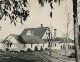
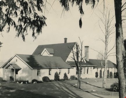
Dania Home
https://search.heritageburnaby.ca/link/archivedescription34585
- Repository
- City of Burnaby Archives
- Date
- 1958
- Collection/Fonds
- Burnaby Historical Society fonds
- Description Level
- Item
- Physical Description
- 1 photograph : b&w ; 17.8 x 22.7 cm
- Scope and Content
- Photograph of the exterior of the Dania Home at 4279 Norland Avenue and Canada Way. The accompanying description reads, "Dania - Modern Danish Rest Home / On site pioneer estate of C.F. Sprott, one of first reeves of Burnaby, Douglas Road - near Norland." The original house, at the centre of the b…
- Repository
- City of Burnaby Archives
- Date
- 1958
- Collection/Fonds
- Burnaby Historical Society fonds
- Subseries
- Photographs subseries
- Physical Description
- 1 photograph : b&w ; 17.8 x 22.7 cm
- Description Level
- Item
- Record No.
- 059-001
- Access Restriction
- No restrictions
- Reproduction Restriction
- Reproduce for fair dealing purposes only
- Accession Number
- BHS2007-04
- Scope and Content
- Photograph of the exterior of the Dania Home at 4279 Norland Avenue and Canada Way. The accompanying description reads, "Dania - Modern Danish Rest Home / On site pioneer estate of C.F. Sprott, one of first reeves of Burnaby, Douglas Road - near Norland." The original house, at the centre of the building, was one of the earliest homes in the Burnaby Lake area, built in 1891 by Charles F. Sprott with the assistance of Bernard R. Hill.
- Names
- Dania Home
- Media Type
- Photograph
- Notes
- Title based on contents of photograph
- Geographic Access
- Norland Avenue
- Street Address
- 4279 Norland Avenue
- Historic Neighbourhood
- Burnaby Lake (Historic Neighbourhood)
- Planning Study Area
- Douglas-Gilpin Area
Images
![Dan Murray on a bicycle, [between 1953 and 1957] (date of original), copied 1991 thumbnail](/media/hpo/_Data/_Archives_Images/_Unrestricted/370/370-151.jpg?width=280)
Dan Murray on a bicycle
https://search.heritageburnaby.ca/link/archivedescription37563
- Repository
- City of Burnaby Archives
- Date
- [between 1953 and 1957] (date of original), copied 1991
- Collection/Fonds
- Burnaby Historical Society fonds
- Description Level
- Item
- Physical Description
- 1 photograph : b&w ; 2.9 x 1.8 cm print on contact sheet 20.2 x 25.3 cm
- Scope and Content
- Photograph of Dan Murray on a bicycle in front of 5623 Georgia Street, at the corner of East Georgia and Holdom Avenue. The photograph was taken facing north.
- Repository
- City of Burnaby Archives
- Date
- [between 1953 and 1957] (date of original), copied 1991
- Collection/Fonds
- Burnaby Historical Society fonds
- Subseries
- Burnaby Image Bank subseries
- Physical Description
- 1 photograph : b&w ; 2.9 x 1.8 cm print on contact sheet 20.2 x 25.3 cm
- Description Level
- Item
- Record No.
- 370-151
- Access Restriction
- No restrictions
- Reproduction Restriction
- No restrictions
- Accession Number
- BHS1999-03
- Scope and Content
- Photograph of Dan Murray on a bicycle in front of 5623 Georgia Street, at the corner of East Georgia and Holdom Avenue. The photograph was taken facing north.
- Names
- Murray, Dan
- Media Type
- Photograph
- Notes
- Title based on contents of photograph
- 1 b&w copy negative accompanying
- Geographic Access
- Georgia Street
- Street Address
- 5623 Georgia Street
- Historic Neighbourhood
- Capitol Hill (Historic Neighbourhood)
- Planning Study Area
- Parkcrest-Aubrey Area
Images
![Dan Murray on a bicycle, [between 1953 and 1957] (date of original), copied 1991 thumbnail](/media/hpo/_Data/_Archives_Images/_Unrestricted/370/370-151.jpg)

Davies Family Home
https://search.heritageburnaby.ca/link/archivedescription37055
- Repository
- City of Burnaby Archives
- Date
- 1950 (date of original), copied 1992
- Collection/Fonds
- Burnaby Historical Society fonds
- Description Level
- Item
- Physical Description
- 1 photograph : b&w ; 8.5 x 12.3 cm print
- Scope and Content
- Photograph of the Davies' home at 224 Boundary Road. A 1950 Studebaker car is parked in front.
- Repository
- City of Burnaby Archives
- Date
- 1950 (date of original), copied 1992
- Collection/Fonds
- Burnaby Historical Society fonds
- Subseries
- Burnaby Centennial Anthology subseries
- Physical Description
- 1 photograph : b&w ; 8.5 x 12.3 cm print
- Description Level
- Item
- Record No.
- 315-518
- Access Restriction
- No restrictions
- Reproduction Restriction
- Reproduce for fair dealing purposes only
- Accession Number
- BHS1994-04
- Scope and Content
- Photograph of the Davies' home at 224 Boundary Road. A 1950 Studebaker car is parked in front.
- Media Type
- Photograph
- Notes
- Title based on contents of photograph
- Geographic Access
- Boundary Road
- Street Address
- 224 Boundary Road North
- Historic Neighbourhood
- Vancouver Heights (Historic Neighbourhood)
- Planning Study Area
- Burnaby Heights Area
Images

![Easthope family home, [between 1940 and 1960] thumbnail](/media/Hpo/_Data/_Archives_Images/_Unrestricted/451/451-002.jpg?width=280)
Easthope family home
https://search.heritageburnaby.ca/link/archivedescription97765
- Repository
- City of Burnaby Archives
- Date
- [between 1940 and 1960]
- Collection/Fonds
- Burnaby Historical Society fonds
- Description Level
- Item
- Physical Description
- 1 photograph : b&w ; 7 cm x 11 cm
- Scope and Content
- Photograph of the exterior of the Easthope home located at 6671 Halifax Street in Burnaby.
- Repository
- City of Burnaby Archives
- Date
- [between 1940 and 1960]
- Collection/Fonds
- Burnaby Historical Society fonds
- Subseries
- Easthope family subseries
- Physical Description
- 1 photograph : b&w ; 7 cm x 11 cm
- Description Level
- Item
- Record No.
- 451-002
- Access Restriction
- No restrictions
- Reproduction Restriction
- Reproduce for fair dealing purposes only
- Accession Number
- BHS2003-06
- Scope and Content
- Photograph of the exterior of the Easthope home located at 6671 Halifax Street in Burnaby.
- Subjects
- Buildings - Residential - Houses
- Media Type
- Photograph
- Notes
- Title based on contents of photograph
- Geographic Access
- Halifax Street
- Street Address
- 6671 Halifax Street
- Historic Neighbourhood
- Lochdale (Historic Neighbourhood)
- Planning Study Area
- Lochdale Area
Images
![Easthope family home, [between 1940 and 1960] thumbnail](/media/Hpo/_Data/_Archives_Images/_Unrestricted/451/451-002.jpg)
![Ellis family home, [1950] (date of original), copied 1991 thumbnail](/media/hpo/_Data/_Archives_Images/_Unrestricted/370/370-353.jpg?width=280)
Ellis family home
https://search.heritageburnaby.ca/link/archivedescription37765
- Repository
- City of Burnaby Archives
- Date
- [1950] (date of original), copied 1991
- Collection/Fonds
- Burnaby Historical Society fonds
- Description Level
- Item
- Physical Description
- 1 photograph : b&w ; 2.7 x 3.9 cm print on contact sheet 20.5 x 26.4 cm
- Scope and Content
- Photograph of 6113 Silver Avenue, the Ellis family home.
- Repository
- City of Burnaby Archives
- Date
- [1950] (date of original), copied 1991
- Collection/Fonds
- Burnaby Historical Society fonds
- Subseries
- Burnaby Image Bank subseries
- Physical Description
- 1 photograph : b&w ; 2.7 x 3.9 cm print on contact sheet 20.5 x 26.4 cm
- Description Level
- Item
- Record No.
- 370-353
- Access Restriction
- No restrictions
- Reproduction Restriction
- No restrictions
- Accession Number
- BHS1999-03
- Scope and Content
- Photograph of 6113 Silver Avenue, the Ellis family home.
- Subjects
- Buildings - Residential - Houses
- Media Type
- Photograph
- Notes
- Title based on contents of photograph
- 1 b&w copy negative accompanying
- Negative has a pink cast
- Geographic Access
- Silver Avenue
- Street Address
- 6113 Silver Avenue
- Historic Neighbourhood
- Central Park (Historic Neighbourhood)
- Planning Study Area
- Maywood Area
Images
![Ellis family home, [1950] (date of original), copied 1991 thumbnail](/media/hpo/_Data/_Archives_Images/_Unrestricted/370/370-353.jpg)