More like 'North Burnaby'
Narrow Results By
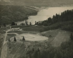
![Burnaby Mountain, [between 1958 and 1965] (date of original), copied 1991 thumbnail](/media/hpo/_Data/_Archives_Images/_Unrestricted/370/370-797.jpg?width=280)
Burnaby Mountain
https://search.heritageburnaby.ca/link/archivedescription38210
- Repository
- City of Burnaby Archives
- Date
- [between 1958 and 1965] (date of original), copied 1991
- Collection/Fonds
- Burnaby Historical Society fonds
- Description Level
- Item
- Physical Description
- 1 photograph : b&w ; 3.2 x 5.1 cm print on contact sheet 20.5 x 26.8 cm
- Scope and Content
- Aerial photograph of Centennial Park, Burnaby Mountain and Burrard Inlet looking east.
- Repository
- City of Burnaby Archives
- Date
- [between 1958 and 1965] (date of original), copied 1991
- Collection/Fonds
- Burnaby Historical Society fonds
- Subseries
- Burnaby Image Bank subseries
- Physical Description
- 1 photograph : b&w ; 3.2 x 5.1 cm print on contact sheet 20.5 x 26.8 cm
- Description Level
- Item
- Record No.
- 370-797
- Access Restriction
- No restrictions
- Reproduction Restriction
- No restrictions
- Accession Number
- BHS1999-03
- Scope and Content
- Aerial photograph of Centennial Park, Burnaby Mountain and Burrard Inlet looking east.
- Subjects
- Aerial Photographs
- Geographic Features - Inlets
- Geographic Features - Mountains
- Geographic Features - Parks
- Media Type
- Photograph
- Notes
- Title based on contents of photograph
- 1 b&w copy negative accompanying
- Geographic Access
- Burnaby Mountain Conservation Area
- Planning Study Area
- Burnaby Mountain Area
Images
![Burnaby Mountain, [between 1958 and 1965] (date of original), copied 1991 thumbnail](/media/hpo/_Data/_Archives_Images/_Unrestricted/370/370-797.jpg)

Standard Oil Company
https://search.heritageburnaby.ca/link/archivedescription34567
- Repository
- City of Burnaby Archives
- Date
- 1958
- Collection/Fonds
- Burnaby Historical Society fonds
- Description Level
- Item
- Physical Description
- 1 photograph : b&w ; 28.0 x 35.8 cm
- Scope and Content
- Aerial photograph of the Standard Oil Company Stanovan Refinery storage and shipping area, along the Burrard Inlet.
- Repository
- City of Burnaby Archives
- Date
- 1958
- Collection/Fonds
- Burnaby Historical Society fonds
- Subseries
- Photographs subseries
- Physical Description
- 1 photograph : b&w ; 28.0 x 35.8 cm
- Description Level
- Item
- Record No.
- 052-003
- Access Restriction
- No restrictions
- Reproduction Restriction
- Reproduce for fair dealing purposes only
- Accession Number
- BHS2007-04
- Scope and Content
- Aerial photograph of the Standard Oil Company Stanovan Refinery storage and shipping area, along the Burrard Inlet.
- Media Type
- Photograph
- Notes
- Title based on contents of photograph
- Geographic Access
- Eton Street
- Street Address
- 4403 Eton Street
- Historic Neighbourhood
- Vancouver Heights (Historic Neighbourhood)
- Planning Study Area
- Burnaby Heights Area
Images

![Trans Mountain Pipe Line loading dock, [1958] thumbnail](/media/Hpo/_Data/_Archives_Images/_Unrestricted/001/098-001.jpg?width=280)
Trans Mountain Pipe Line loading dock
https://search.heritageburnaby.ca/link/archivedescription34689
- Repository
- City of Burnaby Archives
- Date
- [1958]
- Collection/Fonds
- Burnaby Historical Society fonds
- Description Level
- Item
- Physical Description
- 1 photograph : b&w ; 20.4 x 25.3 cm
- Scope and Content
- Aerial photograph of the Trans Mountain Pipe Line Westridge loading dock on Burrard Inlet. Houses are visible in the background, and railroad tracks along the edge of the inlet.
- Repository
- City of Burnaby Archives
- Date
- [1958]
- Collection/Fonds
- Burnaby Historical Society fonds
- Subseries
- Photographs subseries
- Physical Description
- 1 photograph : b&w ; 20.4 x 25.3 cm
- Description Level
- Item
- Record No.
- 098-001
- Access Restriction
- No restrictions
- Reproduction Restriction
- Reproduce for fair dealing purposes only
- Accession Number
- BHS2007-04
- Scope and Content
- Aerial photograph of the Trans Mountain Pipe Line Westridge loading dock on Burrard Inlet. Houses are visible in the background, and railroad tracks along the edge of the inlet.
- Media Type
- Photograph
- Photographer
- Commercial Illustrators Industrial Photographers
- Notes
- Title based on contents of photograph
- Stamp and annotation on back of photograph reads, "TA. 8817 / Commerical Illustrators / Industrial Photographers / 601 Denman St., Vancouver 5, B.C. / File No. 9412-2"
- Historic Neighbourhood
- Lochdale (Historic Neighbourhood)
- Planning Study Area
- Westridge Area
Images
![Trans Mountain Pipe Line loading dock, [1958] thumbnail](/media/Hpo/_Data/_Archives_Images/_Unrestricted/001/098-001.jpg)

Aerial photograph of Timber Preservers Ltd.
https://search.heritageburnaby.ca/link/archivedescription34686
- Repository
- City of Burnaby Archives
- Date
- 1957
- Collection/Fonds
- Burnaby Historical Society fonds
- Description Level
- Item
- Physical Description
- 1 photograph : b&w ; 20.2 x 24.8 cm
- Scope and Content
- Aerial photograph of Timber Preservers Ltd. and the Fraser River at the foot of Trapp Avenue.
- Repository
- City of Burnaby Archives
- Date
- 1957
- Collection/Fonds
- Burnaby Historical Society fonds
- Subseries
- Photographs subseries
- Physical Description
- 1 photograph : b&w ; 20.2 x 24.8 cm
- Description Level
- Item
- Record No.
- 095-001
- Access Restriction
- No restrictions
- Reproduction Restriction
- Reproduce for fair dealing purposes only
- Accession Number
- BHS2007-04
- Scope and Content
- Aerial photograph of Timber Preservers Ltd. and the Fraser River at the foot of Trapp Avenue.
- Media Type
- Photograph
- Photographer
- Campbell Studios Limited
- Notes
- Title based on contents of photograph
- Stamp and annotation on back of photograph reads, "Your Negative Number: 86/[7 or 4]0 / Re-orders any size always obtainable at Campbell Studio / 581 Granville Street, Vancouver, B.C."
- Geographic Access
- Trapp Avenue
- Historic Neighbourhood
- Fraser Arm (Historic Neighbourhood)
- Planning Study Area
- Big Bend Area
Images

![Aerial view of Vancouver, North Vancouver and West Vancouver, [195-] (date of orignal), copied 1985 thumbnail](/media/hpo/_Data/_BVM_Images/1985/1985_0457_0008_001.jpg?width=280)
Aerial view of Vancouver, North Vancouver and West Vancouver
https://search.heritageburnaby.ca/link/museumdescription10589
- Repository
- Burnaby Village Museum
- Date
- [195-] (date of orignal), copied 1985
- Collection/Fonds
- Burnaby Village Museum Photograph collection
- Description Level
- Item
- Physical Description
- 1 photograph : b&w copy negative ; 10 x 12.5 cm
- Scope and Content
- Aerial photograph looking west towards Vancouver, North Vancouver and West Vancouver.
- Repository
- Burnaby Village Museum
- Collection/Fonds
- Burnaby Village Museum Photograph collection
- Description Level
- Item
- Physical Description
- 1 photograph : b&w copy negative ; 10 x 12.5 cm
- Scope and Content
- Aerial photograph looking west towards Vancouver, North Vancouver and West Vancouver.
- Accession Code
- BV985.457.8
- Access Restriction
- No restrictions
- Reproduction Restriction
- May be restricted by third party rights
- Date
- [195-] (date of orignal), copied 1985
- Media Type
- Photograph
- Scan Resolution
- 1200
- Scan Date
- 2022-06-07
- Photographer
- Aero Surveys Limited
- Notes
- Title based on contents of photograph
Images
![Aerial view of Vancouver, North Vancouver and West Vancouver, [195-] (date of orignal), copied 1985 thumbnail](/media/hpo/_Data/_BVM_Images/1985/1985_0457_0008_001.jpg)
![Lenkurt Electric Company, [1957] thumbnail](/media/Hpo/_Data/_Archives_Images/_Unrestricted/001/099-001.jpg?width=280)
Lenkurt Electric Company
https://search.heritageburnaby.ca/link/archivedescription34690
- Repository
- City of Burnaby Archives
- Date
- [1957]
- Collection/Fonds
- Burnaby Historical Society fonds
- Description Level
- Item
- Physical Description
- 1 photograph : b&w ; 20.3 x 25.3 cm
- Scope and Content
- Photograph of aerial view of the Lenkurt Electric Company at 6960 Lougheed Highway (later renumbered 7018 Lougheed Highway). A sign on the top of the building reads, "Lenkurt." An information sheet from the Company Relation Division of Lenkurt attached to the back of the photograph reads, "Aerial…
- Repository
- City of Burnaby Archives
- Date
- [1957]
- Collection/Fonds
- Burnaby Historical Society fonds
- Subseries
- Photographs subseries
- Physical Description
- 1 photograph : b&w ; 20.3 x 25.3 cm
- Description Level
- Item
- Record No.
- 099-001
- Access Restriction
- No restrictions
- Reproduction Restriction
- Reproduce for fair dealing purposes only
- Accession Number
- BHS2007-04
- Scope and Content
- Photograph of aerial view of the Lenkurt Electric Company at 6960 Lougheed Highway (later renumbered 7018 Lougheed Highway). A sign on the top of the building reads, "Lenkurt." An information sheet from the Company Relation Division of Lenkurt attached to the back of the photograph reads, "Aerial view of a 34,000 square foot building including a 19,000 square foot extension to the existing 15,000 square foot plant of Lenkurt Electric Co. of Canada Ltd. in North Burnaby, B.C., as at May 10th, 1957. / The building is situated on 20 acres of land and faces north onto Lougheed Highway."
- Names
- Lenkurt Electric Company
- Media Type
- Photograph
- Photographer
- Commercial Illustrators Industrial Photographers
- Notes
- Title based on contents of photograph
- Stamp and annotation on back of photograph reads, "TA. 8817 / Commerical Illustrators / Industrial Photographers / 601 Denman St., Vancouver 5, B.C. / File No. 1080-1"
- Geographic Access
- Lougheed Highway
- Street Address
- 7018 Lougheed Highway
- Historic Neighbourhood
- Lozells (Historic Neighbourhood)
- Planning Study Area
- Government Road Area
Images
![Lenkurt Electric Company, [1957] thumbnail](/media/Hpo/_Data/_Archives_Images/_Unrestricted/001/099-001.jpg)
![Trans Canada Trail, [2000] thumbnail](/media/hpo/_Data/_Archives_Images/_Unrestricted/535/535-2372.jpg?width=280)
Trans Canada Trail
https://search.heritageburnaby.ca/link/archivedescription96814
- Repository
- City of Burnaby Archives
- Date
- [2000]
- Collection/Fonds
- Burnaby NewsLeader photograph collection
- Description Level
- Item
- Physical Description
- 1 photograph (tiff) : b&w
- Scope and Content
- Photograph of an unidentified person and their dog on the Trans Canada Trail in North Burnaby, overlooking the Burrard Inlet. Industrial ports and plants on the North Shore and the North Shore mountains are visible on the other side of the Inlet.
- Repository
- City of Burnaby Archives
- Date
- [2000]
- Collection/Fonds
- Burnaby NewsLeader photograph collection
- Physical Description
- 1 photograph (tiff) : b&w
- Description Level
- Item
- Record No.
- 535-2372
- Access Restriction
- No restrictions
- Reproduction Restriction
- No restrictions
- Accession Number
- 2018-12
- Scope and Content
- Photograph of an unidentified person and their dog on the Trans Canada Trail in North Burnaby, overlooking the Burrard Inlet. Industrial ports and plants on the North Shore and the North Shore mountains are visible on the other side of the Inlet.
- Media Type
- Photograph
- Photographer
- Bartel, Mario
- Notes
- Title based on caption
- Collected by editorial for use in an April 2000 issue of the Burnaby NewsLeader
- Caption from metadata: "The Trans Canada Trail is popular with dog walkers, offering spectacular vistas of Burrard Inlet and the North Shore Mountains."
- Geographic Access
- Burrard Inlet
- Historic Neighbourhood
- Capitol Hill (Historic Neighbourhood)
- Planning Study Area
- Capitol Hill Area
Images
![Trans Canada Trail, [2000] thumbnail](/media/hpo/_Data/_Archives_Images/_Unrestricted/535/535-2372.jpg)
![Doug Drummond at Barnet Marine Park, [2003] thumbnail](/media/hpo/_Data/_Archives_Images/_Unrestricted/535/535-2277-1.jpg?width=280)
Doug Drummond at Barnet Marine Park
https://search.heritageburnaby.ca/link/archivedescription96655
- Repository
- City of Burnaby Archives
- Date
- [2003]
- Collection/Fonds
- Burnaby NewsLeader photograph collection
- Description Level
- File
- Physical Description
- 2 photographs (tiff) : col.
- Scope and Content
- File contains photographs of former City of Burnaby mayor Doug Drummond at Barnet Marine Park before is improvement and expansion. Photographs depict Drummond standing by the Inlet and walking along the waterfront path with Parks Commissioner Dan Johnston.
- Repository
- City of Burnaby Archives
- Date
- [2003]
- Collection/Fonds
- Burnaby NewsLeader photograph collection
- Physical Description
- 2 photographs (tiff) : col.
- Description Level
- File
- Record No.
- 535-2277
- Access Restriction
- No restrictions
- Reproduction Restriction
- No restrictions
- Accession Number
- 2018-12
- Scope and Content
- File contains photographs of former City of Burnaby mayor Doug Drummond at Barnet Marine Park before is improvement and expansion. Photographs depict Drummond standing by the Inlet and walking along the waterfront path with Parks Commissioner Dan Johnston.
- Subjects
- Geographic Features - Inlets
- Geographic Features - Parks
- Officials - Mayors and Reeves
- Officials - Commissioners
- Media Type
- Photograph
- Photographer
- Bartel, Mario
- Notes
- Title based on caption
- Collected by editorial for use in a March 2003 issue of the Burnaby NewsLeader
- Caption from metadata for 535-2277-1: "Former Burnaby Mayor, Doug Drummond, takes in the view from Barnet Marine Park, which will be expanded to the west, and enhanced with an interpretive centre in the old public works building and a rebuilt wharf reaching into the Burrard Inlet. Improving the park was one of Drummond's goals during his term in office."
- Caption fro metadata for 535-2277-2: "Former Burnaby mayor, Doug Drummond, and the city's parks commissioner, Dan Johnston, stroll along the path at Barnet Marine Park. The park will be expanded to the west, and enhanced with a rebuilt wharf into Burrard Inlet and an interpretive centre in the old public works building. The plan for the park will be the realization of one of Drummond's goals during his term in office."
- Geographic Access
- Barnet Marine Park
- Burrard Inlet
- Historic Neighbourhood
- Barnet (Historic Neighbourhood)
- Planning Study Area
- Burnaby Mountain Area
Images
![Doug Drummond at Barnet Marine Park, [2003] thumbnail](/media/hpo/_Data/_Archives_Images/_Unrestricted/535/535-2277-1.jpg)

From 4042 Yale Street
https://search.heritageburnaby.ca/link/archivedescription37628
- Repository
- City of Burnaby Archives
- Date
- 1952 (date of original), copied 1991
- Collection/Fonds
- Burnaby Historical Society fonds
- Description Level
- Item
- Physical Description
- 1 photograph : b&w ; 2.9 x 4.8 cm print on contact sheet 20.2 x 25.3 cm
- Scope and Content
- Photograph taken looking north from 4042 Yale Street. Burrard Inlet and the northshore mountains are visible in the background, and there is snow.
- Repository
- City of Burnaby Archives
- Date
- 1952 (date of original), copied 1991
- Collection/Fonds
- Burnaby Historical Society fonds
- Subseries
- Burnaby Image Bank subseries
- Physical Description
- 1 photograph : b&w ; 2.9 x 4.8 cm print on contact sheet 20.2 x 25.3 cm
- Description Level
- Item
- Record No.
- 370-216
- Access Restriction
- No restrictions
- Reproduction Restriction
- No restrictions
- Accession Number
- BHS1999-03
- Scope and Content
- Photograph taken looking north from 4042 Yale Street. Burrard Inlet and the northshore mountains are visible in the background, and there is snow.
- Subjects
- Buildings - Residential - Houses
- Geographic Features - Inlets
- Geographic Features - Mountains
- Media Type
- Photograph
- Notes
- Title based on contents of photograph
- 1 b&w copy negative accompanying
- Geographic Access
- Yale Street
- Street Address
- 4042 Yale Street
- Historic Neighbourhood
- Vancouver Heights (Historic Neighbourhood)
- Planning Study Area
- Burnaby Heights Area
Images

![Joseph Santos at Barnet Marine Park, [2001] thumbnail](/media/hpo/_Data/_Archives_Images/_Unrestricted/535/535-2587.jpg?width=280)
Joseph Santos at Barnet Marine Park
https://search.heritageburnaby.ca/link/archivedescription97059
- Repository
- City of Burnaby Archives
- Date
- [2001]
- Collection/Fonds
- Burnaby NewsLeader photograph collection
- Description Level
- Item
- Physical Description
- 1 photograph (tiff) : col.
- Scope and Content
- Photograph of Joseph Santos in a rain poncho, searching for sea worms on the shores of the Burrard Inlet at Barnet Marine Park. An unidentified person fishing off the pier is visible behind Santos.
- Repository
- City of Burnaby Archives
- Date
- [2001]
- Collection/Fonds
- Burnaby NewsLeader photograph collection
- Physical Description
- 1 photograph (tiff) : col.
- Description Level
- Item
- Record No.
- 535-2587
- Access Restriction
- No restrictions
- Reproduction Restriction
- No restrictions
- Accession Number
- 2018-12
- Scope and Content
- Photograph of Joseph Santos in a rain poncho, searching for sea worms on the shores of the Burrard Inlet at Barnet Marine Park. An unidentified person fishing off the pier is visible behind Santos.
- Media Type
- Photograph
- Photographer
- Bartel, Mario
- Notes
- Title based on caption
- Collected by editorial for use in a July 2001 issue of the Burnaby NewsLeader
- Caption from metadata: "Joseph Santos isn't deterred by the soggy weather as he searches for sea worms to be used as bait at a family fishing expedition at Barnet Marine Park."
- Geographic Access
- Barnet Marine Park
- Burrard Inlet
- Historic Neighbourhood
- Barnet (Historic Neighbourhood)
- Planning Study Area
- Burnaby Mountain Area
Images
![Joseph Santos at Barnet Marine Park, [2001] thumbnail](/media/hpo/_Data/_Archives_Images/_Unrestricted/535/535-2587.jpg)
![Trans Canada Trail in North Burnaby, [2000] thumbnail](/media/hpo/_Data/_Archives_Images/_Unrestricted/535/535-2117-1.jpg?width=280)
Trans Canada Trail in North Burnaby
https://search.heritageburnaby.ca/link/archivedescription96493
- Repository
- City of Burnaby Archives
- Date
- [2000]
- Collection/Fonds
- Burnaby NewsLeader photograph collection
- Description Level
- File
- Physical Description
- 2 photographs (tiff) : col.
- Scope and Content
- File contains photographs of Ruth Hardy, Anita Loy, and Trudy Mile walking the Trans Canada Trail in North Burnaby. Photographs depict them enjoying a view of the Burrard Inlet from the Heights Trail leg and walking past a trail marker that reads: "The Heights Trail."
- Repository
- City of Burnaby Archives
- Date
- [2000]
- Collection/Fonds
- Burnaby NewsLeader photograph collection
- Physical Description
- 2 photographs (tiff) : col.
- Description Level
- File
- Record No.
- 535-2117
- Access Restriction
- No restrictions
- Reproduction Restriction
- No restrictions
- Accession Number
- 2018-12
- Scope and Content
- File contains photographs of Ruth Hardy, Anita Loy, and Trudy Mile walking the Trans Canada Trail in North Burnaby. Photographs depict them enjoying a view of the Burrard Inlet from the Heights Trail leg and walking past a trail marker that reads: "The Heights Trail."
- Media Type
- Photograph
- Photographer
- Bartel, Mario
- Notes
- Title based on caption
- Collected by editorial for use in a March 2000 issue of the Burnaby NewsLeader
- Caption from metadata for 535-2117-1: "Ruth Hardy, Anita Loy and Trudy Mile enjoy some of the views along the Heights Trail leg of the Trans Canada Trail, as it winds along Burrard Inlet."
- Caption from metadata for 535-2117-2: "Ruth Hardy, Trudy Mile and Anita Loy get a little exercise along the Trans Canada Trail as it winds through North Burnaby."
- Geographic Access
- Burrard Inlet
- Burnaby Heights Park
- Historic Neighbourhood
- Vancouver Heights (Historic Neighbourhood)
- Planning Study Area
- Burnaby Heights Area
Images
![Trans Canada Trail in North Burnaby, [2000] thumbnail](/media/hpo/_Data/_Archives_Images/_Unrestricted/535/535-2117-1.jpg)

View from Kask's Camp
https://search.heritageburnaby.ca/link/archivedescription35531
- Repository
- City of Burnaby Archives
- Date
- 1950 (date of original), copied 1986
- Collection/Fonds
- Burnaby Historical Society fonds
- Description Level
- Item
- Physical Description
- 1 photograph : b&w ; 12.7 x 17.8 cm print
- Scope and Content
- Photograph of top of the hill moved by William Kask, Sr. at the request of Jenny Korhonen Kask who wanted a better view of Burrard Inlet and the islands from her house in Kask's Camp, later Kask Bros. Cement Works. Mr. Kask had the top of the mountain shave off with a bulldozer. A Vancouver Sun h…
- Repository
- City of Burnaby Archives
- Date
- 1950 (date of original), copied 1986
- Collection/Fonds
- Burnaby Historical Society fonds
- Subseries
- Pioneer Tales subseries
- Physical Description
- 1 photograph : b&w ; 12.7 x 17.8 cm print
- Description Level
- Item
- Record No.
- 204-389
- Access Restriction
- No restrictions
- Reproduction Restriction
- Reproduce for fair dealing purposes only
- Accession Number
- BHS1988-03
- Scope and Content
- Photograph of top of the hill moved by William Kask, Sr. at the request of Jenny Korhonen Kask who wanted a better view of Burrard Inlet and the islands from her house in Kask's Camp, later Kask Bros. Cement Works. Mr. Kask had the top of the mountain shave off with a bulldozer. A Vancouver Sun headline read, "Man Moves Mountain."
- Media Type
- Photograph
- Notes
- Title based on contents of photograph
- Geographic Access
- Barnet Road
- Street Address
- 7501 Barnet Road
- Historic Neighbourhood
- Barnet (Historic Neighbourhood)
- Planning Study Area
- Burnaby Mountain Area
Images

![Dover Street crosswalk lights, [2000] thumbnail](/media/hpo/_Data/_Archives_Images/_Unrestricted/535/535-2540.jpg?width=280)
Dover Street crosswalk lights
https://search.heritageburnaby.ca/link/archivedescription97008
- Repository
- City of Burnaby Archives
- Date
- [2000]
- Collection/Fonds
- Burnaby NewsLeader photograph collection
- Description Level
- Item
- Physical Description
- 1 photograph (tiff) : col.
- Scope and Content
- Photograph of the assistant director of traffic engineering at the City of Burnaby examining a piece of equipment installed in Dover Street as part of a pilot project for new crosswalk lights. A school crosswalk sign and passing vehicle are visible in the background.
- Repository
- City of Burnaby Archives
- Date
- [2000]
- Collection/Fonds
- Burnaby NewsLeader photograph collection
- Physical Description
- 1 photograph (tiff) : col.
- Description Level
- Item
- Record No.
- 535-2540
- Access Restriction
- No restrictions
- Reproduction Restriction
- No restrictions
- Accession Number
- 2018-12
- Scope and Content
- Photograph of the assistant director of traffic engineering at the City of Burnaby examining a piece of equipment installed in Dover Street as part of a pilot project for new crosswalk lights. A school crosswalk sign and passing vehicle are visible in the background.
- Subjects
- Geographic Features - Roads
- Geographic Features - Sidewalks
- Occupations - Civic Workers
- Public Services - Public Works
- Media Type
- Photograph
- Photographer
- Bartel, Mario
- Notes
- Title based on caption
- Collected by editorial for use in a July 2000 issue of the Burnaby NewsLeader
- Caption from metadata: "Burnaby's assistand director of traffic engineering examines the new crosswalk lights, installed as a pilot project, on Dover, between Royal Oak and Nelson."
- Geographic Access
- Dover Street
- Nelson Avenue
- Royal Oak Avenue
- Historic Neighbourhood
- Central Park (Historic Neighbourhood)
- Planning Study Area
- Marlborough Area
Images
![Dover Street crosswalk lights, [2000] thumbnail](/media/hpo/_Data/_Archives_Images/_Unrestricted/535/535-2540.jpg)
Burnaby Mountain Pavilion
https://search.heritageburnaby.ca/link/archivedescription34702
- Repository
- City of Burnaby Archives
- Date
- 1958
- Collection/Fonds
- Burnaby Historical Society fonds
- Description Level
- Item
- Physical Description
- 1 photograph : b&w ; 17.4 x 20.4 cm
- Scope and Content
- Photograph of the exterior of Burnaby Mountain Pavilion with Burrard Inlet in the background.
- Repository
- City of Burnaby Archives
- Date
- 1958
- Collection/Fonds
- Burnaby Historical Society fonds
- Subseries
- Photographs subseries
- Physical Description
- 1 photograph : b&w ; 17.4 x 20.4 cm
- Description Level
- Item
- Record No.
- 107-001
- Access Restriction
- No restrictions
- Reproduction Restriction
- Reproduce for fair dealing purposes only
- Accession Number
- BHS2007-04
- Scope and Content
- Photograph of the exterior of Burnaby Mountain Pavilion with Burrard Inlet in the background.
- Media Type
- Photograph
- Notes
- Title based on contents of photograph
- Geographic Access
- Burnaby Mountain Conservation Area
- Planning Study Area
- Burnaby Mountain Area
Images

![Harry Pride and Barnet townsite, [2004] thumbnail](/media/hpo/_Data/_Archives_Images/_Unrestricted/535/535-2056-1.jpg?width=280)
Harry Pride and Barnet townsite
https://search.heritageburnaby.ca/link/archivedescription96386
- Repository
- City of Burnaby Archives
- Date
- [2004]
- Collection/Fonds
- Burnaby NewsLeader photograph collection
- Description Level
- File
- Physical Description
- 3 photographs (tiff) : col.
- Scope and Content
- File contains photographs of Harry Pride at work on researching his book about Burnaby's Barnet townsite. Photographs depict Pride with Beatrice Woolsey-McMillan, a former resident of the community, on the shore of the Burrard Inlet, and Pride viewing historical photographs and one of the remaining…
- Repository
- City of Burnaby Archives
- Date
- [2004]
- Collection/Fonds
- Burnaby NewsLeader photograph collection
- Physical Description
- 3 photographs (tiff) : col.
- Description Level
- File
- Record No.
- 535-2056
- Access Restriction
- No restrictions
- Reproduction Restriction
- No restrictions
- Accession Number
- 2018-12
- Scope and Content
- File contains photographs of Harry Pride at work on researching his book about Burnaby's Barnet townsite. Photographs depict Pride with Beatrice Woolsey-McMillan, a former resident of the community, on the shore of the Burrard Inlet, and Pride viewing historical photographs and one of the remaining structures from the Barnet sawmill.
- Subjects
- Geographic Features - Inlets
- Buildings - Industrial - Saw Mills
- Buildings - Industrial - Mills
- Media Type
- Photograph
- Photographer
- Bartel, Mario
- Notes
- Title based on caption
- Collected by editorial for use in a March 2004 issue of the Burnaby NewsLeader
- Caption from metadata for 535-2056-1: "Harry Pride, who is working on a book about Burnaby's Barnet townsite, reminisces with Beatrice Woolsey-McMillan, who lived in the mill community along the Burrard Inlet from 1925-46."
- Caption from metadata for 535-2056-2: "Harry Pride sorts through some of the historical photos he's collected for a book he's working on about Burnaby's Barnet townsite, along the Burrard Inlet."
- Caption from metadata for 535-2056-3: "Harry Pride, who's working on a book about Burnaby's Barnet townsite, checks out one of the remaining structures from the sawmill that once bustled along the Burrard Inlet."
- Geographic Access
- Barnet Village
- Burrard Inlet
- Barnet Marine Park
- Historic Neighbourhood
- Barnet (Historic Neighbourhood)
- Planning Study Area
- Burnaby Mountain Area
Images
![Harry Pride and Barnet townsite, [2004] thumbnail](/media/hpo/_Data/_Archives_Images/_Unrestricted/535/535-2056-1.jpg)
Aerial photograph of Burnaby Mountain
https://search.heritageburnaby.ca/link/archivedescription64460
- Repository
- City of Burnaby Archives
- Date
- [1957 or 1958]
- Collection/Fonds
- Burnaby Historical Society fonds
- Description Level
- Item
- Physical Description
- 1 photograph : b&w ; 14 x 14 cm
- Scope and Content
- Aerial photograph of the Burnaby Mountain park and Centennial Pavilion, under construction.
- Repository
- City of Burnaby Archives
- Date
- [1957 or 1958]
- Collection/Fonds
- Burnaby Historical Society fonds
- Subseries
- North Burnaby Board of Trade subseries
- Physical Description
- 1 photograph : b&w ; 14 x 14 cm
- Description Level
- Item
- Record No.
- 476-026
- Access Restriction
- No restrictions
- Reproduction Restriction
- Reproduce for fair dealing purposes only
- Accession Number
- BHS2005-8
- Scope and Content
- Aerial photograph of the Burnaby Mountain park and Centennial Pavilion, under construction.
- Subjects
- Aerial Photographs
- Land Clearing
- Media Type
- Photograph
- Photographer
- Hunting Survey Corporation Limited
- Notes
- Title based on contents of photograph
- Geographic Access
- Burnaby Mountain Conservation Area
- Centennial Way
- Street Address
- 100 Centennial Way
- Planning Study Area
- Burnaby Mountain Area
![Aerial photograph of Burnaby Mountain, [1957 or 1958] thumbnail](/media/hpo/_Data/_Archives_Images/_Unrestricted/371/476-024.jpg?width=280)
Aerial photograph of Burnaby Mountain
https://search.heritageburnaby.ca/link/archivedescription38681
- Repository
- City of Burnaby Archives
- Date
- [1957 or 1958]
- Collection/Fonds
- Burnaby Historical Society fonds
- Description Level
- Item
- Physical Description
- 1 photograph : b&w ; 19 x 24 cm
- Scope and Content
- Aerial photograph of Burnaby Mountain and the Centennial Pavilion, built to mark the 1958 centennial.
- Repository
- City of Burnaby Archives
- Date
- [1957 or 1958]
- Collection/Fonds
- Burnaby Historical Society fonds
- Subseries
- North Burnaby Board of Trade subseries
- Physical Description
- 1 photograph : b&w ; 19 x 24 cm
- Description Level
- Item
- Record No.
- 476-024
- Access Restriction
- No restrictions
- Reproduction Restriction
- Reproduce for fair dealing purposes only
- Accession Number
- BHS2005-8
- Scope and Content
- Aerial photograph of Burnaby Mountain and the Centennial Pavilion, built to mark the 1958 centennial.
- Subjects
- Aerial Photographs
- Media Type
- Photograph
- Photographer
- Rossmo, Nicholas
- Notes
- Title based on contents of photograph
- Geographic Access
- Burnaby Mountain Conservation Area
- Centennial Way
- Street Address
- 100 Centennial Way
- Planning Study Area
- Burnaby Mountain Area
Images
![Aerial photograph of Burnaby Mountain, [1957 or 1958] thumbnail](/media/hpo/_Data/_Archives_Images/_Unrestricted/371/476-024.jpg)
![Aerial photograph of Burnaby Mountain, [1957 or 1958] thumbnail](/media/hpo/_Data/_Archives_Images/_Unrestricted/371/476-025.jpg?width=280)
Aerial photograph of Burnaby Mountain
https://search.heritageburnaby.ca/link/archivedescription39742
- Repository
- City of Burnaby Archives
- Date
- [1957 or 1958]
- Collection/Fonds
- Burnaby Historical Society fonds
- Description Level
- Item
- Physical Description
- 1 photograph : b&w ; 14 x 14 cm
- Scope and Content
- Aerial photograph of the Burnaby Mountain park and Centennial Pavilion, under construction.
- Repository
- City of Burnaby Archives
- Date
- [1957 or 1958]
- Collection/Fonds
- Burnaby Historical Society fonds
- Subseries
- North Burnaby Board of Trade subseries
- Physical Description
- 1 photograph : b&w ; 14 x 14 cm
- Description Level
- Item
- Record No.
- 476-025
- Access Restriction
- No restrictions
- Reproduction Restriction
- Reproduce for fair dealing purposes only
- Accession Number
- BHS2005-8
- Scope and Content
- Aerial photograph of the Burnaby Mountain park and Centennial Pavilion, under construction.
- Subjects
- Aerial Photographs
- Land Clearing
- Media Type
- Photograph
- Photographer
- Hunting Survey Corporation Limited
- Notes
- Title based on contents of photograph.
- Geographic Access
- Burnaby Mountain Conservation Area
- Centennial Way
- Street Address
- 100 Centennial Way
- Planning Study Area
- Burnaby Mountain Area
Images
![Aerial photograph of Burnaby Mountain, [1957 or 1958] thumbnail](/media/hpo/_Data/_Archives_Images/_Unrestricted/371/476-025.jpg)

Aerial photograph of Grandview Highway
https://search.heritageburnaby.ca/link/archivedescription37876
- Repository
- City of Burnaby Archives
- Date
- July 1952 (date of original), copied 1991
- Collection/Fonds
- Burnaby Historical Society fonds
- Description Level
- Item
- Physical Description
- 1 photograph : b&w ; 3.4 x 4.3 cm print on contact sheet 20.1 x 26.7 cm
- Scope and Content
- Aerial photograph of Cascade Drive-In Theatre at 4050 Grandview Highway and the surrounding area. Note: Burnaby General Hospital under construction can be seen on the left.
- Repository
- City of Burnaby Archives
- Date
- July 1952 (date of original), copied 1991
- Collection/Fonds
- Burnaby Historical Society fonds
- Subseries
- Burnaby Image Bank subseries
- Physical Description
- 1 photograph : b&w ; 3.4 x 4.3 cm print on contact sheet 20.1 x 26.7 cm
- Description Level
- Item
- Record No.
- 370-464
- Access Restriction
- No restrictions
- Reproduction Restriction
- No restrictions
- Accession Number
- BHS1999-03
- Scope and Content
- Aerial photograph of Cascade Drive-In Theatre at 4050 Grandview Highway and the surrounding area. Note: Burnaby General Hospital under construction can be seen on the left.
- Subjects
- Aerial Photographs
- Media Type
- Photograph
- Photographer
- Cunningham, W.
- Notes
- Title based on contents of photograph
- 1 b&w copy negative accompanying
- Negative has a pink cast
- Geographic Access
- Grandview Highway
- Street Address
- 4050 Grandview Highway
- Historic Neighbourhood
- Broadview (Historic Neighbourhood)
- Planning Study Area
- Cascade-Schou Area
- West Central Valley Area
Images

![Aerial View of Chinese Market Gardens on Marine Drive, [between 1950 and 1959] (date of original), 2017 (date of duplication) thumbnail](/media/hpo/_Data/_BVM_Images/2017/2017_0040_0001_001.jpg?width=280)
Aerial View of Chinese Market Gardens on Marine Drive
https://search.heritageburnaby.ca/link/museumdescription4296
- Repository
- Burnaby Village Museum
- Date
- [between 1950 and 1959] (date of original), 2017 (date of duplication)
- Collection/Fonds
- Herbert Yee Law family fonds
- Description Level
- Item
- Physical Description
- 1 photograph (jpg) : b&w
- Scope and Content
- Photograph is an aerial view looking south over the Chinese Market Gardens along Marine Drive in the Big Bend area of Burnaby.
- Repository
- Burnaby Village Museum
- Collection/Fonds
- Herbert Yee Law family fonds
- Description Level
- Item
- Physical Description
- 1 photograph (jpg) : b&w
- Scope and Content
- Photograph is an aerial view looking south over the Chinese Market Gardens along Marine Drive in the Big Bend area of Burnaby.
- Names
- Chinese Market Gardens
- Geographic Access
- Marine Drive
- Accession Code
- BV017.40.1
- Access Restriction
- No restrictions
- Reproduction Restriction
- May be restricted by third party rights
- Date
- [between 1950 and 1959] (date of original), 2017 (date of duplication)
- Media Type
- Photograph
- Historic Neighbourhood
- Fraser Arm (Historic Neighbourhood)
- Planning Study Area
- Big Bend Area
- Scan Resolution
- 600
- Scan Date
- 11/19/2017
- Scale
- 100
- Notes
- Title based on contents of photograph.
Images
![Aerial View of Chinese Market Gardens on Marine Drive, [between 1950 and 1959] (date of original), 2017 (date of duplication) thumbnail](/media/hpo/_Data/_BVM_Images/2017/2017_0040_0001_001.jpg)