More like 'postcard'
Narrow Results By
Decade
- 2020s 87
- 2010s 41
- 2000s 491
- 1990s
- 1980s 388
- 1970s 841
- 1960s 357
- 1950s
- 1940s 494
- 1930s 395
- 1920s 439
- 1910s 483
- 1900s 210
- 1890s 39
- 1880s 64
- 1870s 5
- 1860s 3
- 1850s 3
- 1840s 1
- 1830s 2
- 1820s 1
- 1810s 1
- 1800s 1
- 1790s 1
- 1780s 1
- 1770s 1
- 1760s 1
- 1750s 1
- 1740s 1
- 1730s 1
- 1720s 1
- 1710s 1
- 1700s 1
- 1690s 1
- 1680s 1
- 1670s 1
- 1660s 1
- 1650s 1
- 1640s 1
- 1630s 1
- 1620s 1
- 1610s 1
- 1600s 1

Helen 'The Swinging Girl' Neon Sign
https://search.heritageburnaby.ca/link/landmark591
- Repository
- Burnaby Heritage Planning
- Description
- Commercial building.
- Associated Dates
- 1956
- Formal Recognition
- Heritage Designation, Community Heritage Register
- Other Names
- Helen's Childrens Wear Sign
- Street View URL
- Google Maps Street View
- Repository
- Burnaby Heritage Planning
- Other Names
- Helen's Childrens Wear Sign
- Geographic Access
- Hastings Street
- Associated Dates
- 1956
- Formal Recognition
- Heritage Designation, Community Heritage Register
- Enactment Type
- Bylaw No. 12771
- Enactment Date
- 19/04/2010
- Description
- Commercial building.
- Heritage Value
- While the building here is of some importance as the former North Burnaby municipal office, its primary importance is its delightful neon sign that has become a North Burnaby landmark. Helen Arnold opened Helen’s Childrens Wear shop in the building next door to the old Municipal offices in 1948. In 1955, when North Burnaby moved out, she moved into the vacated building. As part of the renovations, Helen enlisted the assistance of her good friend Jimmy Wallace, owner of Vancouver’s Wallace Neon Company, to create a new sign for her expanded business. One of the company’s designers, Reeve Lehman, created the swinging neon girl that was installed in 1956. Designed in two parts, one section of the sign is cloud shaped and reads ‘Helen’s’ while the other section is a moving representation of a little girl on a swing. The sign is nine feet six inches high and nine feet wide, and the lower section is animated with an internal motor and gears. It immediately became a landmark on Hastings Street, and recently the sign’s design fame has spread far and wide as one of the best surviving examples of kinetic neon art in North America.
- Locality
- Vancouver Heights
- Historic Neighbourhood
- Vancouver Heights (Historic Neighbourhood)
- Planning Study Area
- Willingdon Heights Area
- Community
- Burnaby
- Names
- Helen's Childrens Wear
- Street Address
- 4142 Hastings Street
- Street View URL
- Google Maps Street View
Images


![The Fair Haven, [between 1950 and 1957] thumbnail](/media/Hpo/_Data/_Archives_Images/_Unrestricted/251/305-001.jpg?width=280)
The Fair Haven
https://search.heritageburnaby.ca/link/archivedescription36597
- Repository
- City of Burnaby Archives
- Date
- [between 1950 and 1957]
- Collection/Fonds
- Burnaby Historical Society fonds
- Description Level
- Item
- Physical Description
- 1 photograph : col. postcard ; 9 x 14 cm
- Scope and Content
- Aerial photographic postcard of "the Fair Haven," a group of United Church homes for Senior Citizens. The road in the foreground is Rumble Street, and the long road to the right is Sussex Avenue. The small forest behind "the Fair Haven" is the David Gary Park.
- Repository
- City of Burnaby Archives
- Date
- [between 1950 and 1957]
- Collection/Fonds
- Burnaby Historical Society fonds
- Subseries
- Vera Jackson Pel subseries
- Physical Description
- 1 photograph : col. postcard ; 9 x 14 cm
- Description Level
- Item
- Record No.
- 305-001
- Access Restriction
- No restrictions
- Reproduction Restriction
- Reproduce for fair dealing purposes only
- Accession Number
- BHS1992-46
- Scope and Content
- Aerial photographic postcard of "the Fair Haven," a group of United Church homes for Senior Citizens. The road in the foreground is Rumble Street, and the long road to the right is Sussex Avenue. The small forest behind "the Fair Haven" is the David Gary Park.
- Subjects
- Aerial Photographs
- Documentary Artifacts - Postcards
- Buildings - Residential - Seniors Housing
- Names
- Fair Haven
- Media Type
- Photograph
- Notes
- Typewritten note on verso of postcard reads: "AERIAL VIEW/ 'The Fairhaven', Burnaby BC / United Church Homes for Senior Citizens / 4341 Rumble St., Burnaby, BC"
- Handwritten note on verso of postcard reads: ""The road in the foreground is Rumble Street. The long road to the right is Sussex Avenue. The road, going up, on the left, barely visible is McKay Avenue = lower corner. Behind Fair Haven is the future David Gary Park cleared in the late 1950's - then more trees were felled in October 1962 with Hurricane Freda (blown over, uprooted trees) that left the park as it is today in 1993. The top row of little (5) white cottages were moved from the N.W. corner of Willingdon and Kingsway where Old Orchard Mall is now - they were part of Old Orchard Auto Villas, the first Fair Havens. Note: All cottages on right side of Lodge have been moved to Vancouver Island in 1991 for Motel units - by barge."
- Printed on verso of postcard: "Traveltime product, made in Vancouver, Canada, by Grant-Mann Lithographers Ltd."
- Geographic Access
- Rumble Street
- Street Address
- 4341 Rumble Street
- Historic Neighbourhood
- Alta-Vista (Historic Neighbourhood)
- Planning Study Area
- Sussex-Nelson Area
Images
![The Fair Haven, [between 1950 and 1957] thumbnail](/media/Hpo/_Data/_Archives_Images/_Unrestricted/251/305-001.jpg)
![George Derby Health Centre, [between 1950 and 1954] (date of original), copied 1991 thumbnail](/media/hpo/_Data/_Archives_Images/_Unrestricted/370/370-127.jpg?width=280)
George Derby Health Centre
https://search.heritageburnaby.ca/link/archivedescription37539
- Repository
- City of Burnaby Archives
- Date
- [between 1950 and 1954] (date of original), copied 1991
- Collection/Fonds
- Burnaby Historical Society fonds
- Description Level
- Item
- Physical Description
- 1 photograph : b&w ; 3.4 x 5.0 cm print on contact sheet 20.2 x 25.3 cm
- Scope and Content
- Aerial photograph of the George Derby Health Centre, copied from a postcard.
- Repository
- City of Burnaby Archives
- Date
- [between 1950 and 1954] (date of original), copied 1991
- Collection/Fonds
- Burnaby Historical Society fonds
- Subseries
- Burnaby Image Bank subseries
- Physical Description
- 1 photograph : b&w ; 3.4 x 5.0 cm print on contact sheet 20.2 x 25.3 cm
- Description Level
- Item
- Record No.
- 370-127
- Access Restriction
- No restrictions
- Reproduction Restriction
- No restrictions
- Accession Number
- BHS1999-03
- Scope and Content
- Aerial photograph of the George Derby Health Centre, copied from a postcard.
- Media Type
- Photograph
- Notes
- Title based on caption on photograph
- 1 b&w copy negative accompanying
- Caption on photograph reads, "George Derby Health Centre, Burnaby B.C."
- Geographic Access
- Cumberland Street
- Street Address
- 7550 Cumberland Street
- Historic Neighbourhood
- East Burnaby (Historic Neighbourhood)
- Planning Study Area
- Cariboo-Armstrong Area
Images
![George Derby Health Centre, [between 1950 and 1954] (date of original), copied 1991 thumbnail](/media/hpo/_Data/_Archives_Images/_Unrestricted/370/370-127.jpg)

The Benedictines of Westminster Priory
https://search.heritageburnaby.ca/link/archivedescription38167
- Repository
- City of Burnaby Archives
- Date
- 1951 (date of original), copied 1991
- Collection/Fonds
- Burnaby Historical Society fonds
- Description Level
- Item
- Physical Description
- 1 photograph : b&w ; 3.3 x 5.3 cm print on contact sheet 20.1 x 26.3 cm
- Scope and Content
- Photograph of an original photographic postcard of the Benedictines of Westminster Priory at Ceperley House which was funded by the Catholic Diocese beginning in 1939. There is a postmark from Merritt, British Columbia, at the top right corner.
- Repository
- City of Burnaby Archives
- Date
- 1951 (date of original), copied 1991
- Collection/Fonds
- Burnaby Historical Society fonds
- Subseries
- Burnaby Image Bank subseries
- Physical Description
- 1 photograph : b&w ; 3.3 x 5.3 cm print on contact sheet 20.1 x 26.3 cm
- Description Level
- Item
- Record No.
- 370-754
- Access Restriction
- No restrictions
- Reproduction Restriction
- No restrictions
- Accession Number
- BHS1999-03
- Scope and Content
- Photograph of an original photographic postcard of the Benedictines of Westminster Priory at Ceperley House which was funded by the Catholic Diocese beginning in 1939. There is a postmark from Merritt, British Columbia, at the top right corner.
- Subjects
- Buildings - Religious
- Buildings - Heritage
- Occupations - Clergy
- Documentary Artifacts - Postcards
- Names
- Westminster Priory
- Media Type
- Photograph
- Notes
- 1 b&w copy negative accompanying
- Negative has a pink cast
- Annotation at bottom of photograph reads, "The Benedictines of Westminster Priory, Vancouver, BC"
- Geographic Access
- Deer Lake Avenue
- Street Address
- 6344 Deer Lake Avenue
- Historic Neighbourhood
- Burnaby Lake (Historic Neighbourhood)
- Planning Study Area
- Douglas-Gilpin Area
Images

![Haida Grill at the Astor Hotel, [between 1955 and 1959] thumbnail](/media/hpo/_Data/_Archives_Images/_Unrestricted/316/327-001.jpg?width=280)
Haida Grill at the Astor Hotel
https://search.heritageburnaby.ca/link/archivedescription37173
- Repository
- City of Burnaby Archives
- Date
- [between 1955 and 1959]
- Collection/Fonds
- Burnaby Historical Society fonds
- Description Level
- Item
- Physical Description
- 1 postcard ; col. ; 8 x 13 cm
- Scope and Content
- Postcard with a photograph of the Haida Grill at the Astor Hotel, which was known as being Burnaby's million dollar, ultra-modern hotel.
- Repository
- City of Burnaby Archives
- Date
- [between 1955 and 1959]
- Collection/Fonds
- Burnaby Historical Society fonds
- Subseries
- Lee Lightfoot subseries
- Physical Description
- 1 postcard ; col. ; 8 x 13 cm
- Description Level
- Item
- Record No.
- 327-001
- Access Restriction
- No restrictions
- Reproduction Restriction
- Reproduce for fair dealing purposes only
- Accession Number
- BHS1996-13
- Scope and Content
- Postcard with a photograph of the Haida Grill at the Astor Hotel, which was known as being Burnaby's million dollar, ultra-modern hotel.
- Subjects
- Buildings - Commercial - Hotels and Motels
- Buildings - Commercial - Restaurants
- Documentary Artifacts - Postcards
- Names
- Astor Hotel
- Media Type
- Photograph
- Notes
- Title based on contents of photograph
- Caption on recto of postcard reads: "ASTOR HOTEL . 4561 KINGSWAY, BURNABY 1, B.C."
- Caption on verso of postcard reads: "THE HAIDA GRILL/ The delightful setting and excellent cuisine makes the Haida Grill a must for dining pleasure. A Photograph [sic] showing the Haida Grill with its table side service."
- Geographic Access
- Kingsway
- Street Address
- 4561 Kingsway
- Historic Neighbourhood
- Central Park (Historic Neighbourhood)
- Planning Study Area
- Marlborough Area
Images
![Haida Grill at the Astor Hotel, [between 1955 and 1959] thumbnail](/media/hpo/_Data/_Archives_Images/_Unrestricted/316/327-001.jpg)
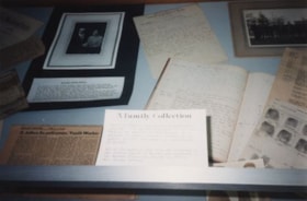
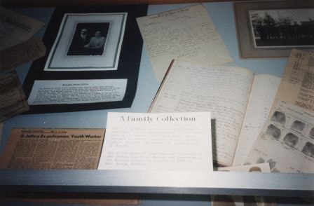
A Family Collection
https://search.heritageburnaby.ca/link/archivedescription36452
- Repository
- City of Burnaby Archives
- Date
- 1990
- Collection/Fonds
- Burnaby Historical Society fonds
- Description Level
- Item
- Physical Description
- 1 photograph : col. ; 10 x 15 cm
- Scope and Content
- Photograph of the George Jeffrey family collection on display during the opening of the Burnaby Community Archives at the Burnaby Village Museum.
- Repository
- City of Burnaby Archives
- Date
- 1990
- Collection/Fonds
- Burnaby Historical Society fonds
- Subseries
- Donald N. Brown subseries
- Physical Description
- 1 photograph : col. ; 10 x 15 cm
- Description Level
- Item
- Record No.
- 271-020
- Access Restriction
- No restrictions
- Reproduction Restriction
- Reproduce for fair dealing purposes only
- Accession Number
- BHS1991-41
- Scope and Content
- Photograph of the George Jeffrey family collection on display during the opening of the Burnaby Community Archives at the Burnaby Village Museum.
- Media Type
- Photograph
- Notes
- 1 col. negative accompanying
- Geographic Access
- Deer Lake Avenue
- Street Address
- 6501 Deer Lake Avenue
- Historic Neighbourhood
- Burnaby Lake (Historic Neighbourhood)
- Planning Study Area
- Morley-Buckingham Area
Images
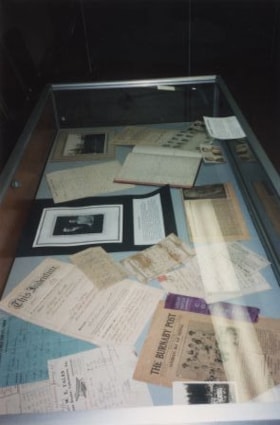
George Jeffrey family collection
https://search.heritageburnaby.ca/link/archivedescription36453
- Repository
- City of Burnaby Archives
- Date
- 1990
- Collection/Fonds
- Burnaby Historical Society fonds
- Description Level
- Item
- Physical Description
- 1 photograph : col. ; 15 x 10 cm
- Scope and Content
- Photograph of the display case that housed the George Jeffrey family collection during the opening of the Burnaby Community Archives at the Burnaby Village Museum.
- Repository
- City of Burnaby Archives
- Date
- 1990
- Collection/Fonds
- Burnaby Historical Society fonds
- Subseries
- Donald N. Brown subseries
- Physical Description
- 1 photograph : col. ; 15 x 10 cm
- Description Level
- Item
- Record No.
- 271-021
- Access Restriction
- No restrictions
- Reproduction Restriction
- Reproduce for fair dealing purposes only
- Accession Number
- BHS1991-41
- Scope and Content
- Photograph of the display case that housed the George Jeffrey family collection during the opening of the Burnaby Community Archives at the Burnaby Village Museum.
- Media Type
- Photograph
- Notes
- Title based on contents of photograph
- 1 col. negative accompanying
- Geographic Access
- Deer Lake Avenue
- Street Address
- 6501 Deer Lake Avenue
- Historic Neighbourhood
- Burnaby Lake (Historic Neighbourhood)
- Planning Study Area
- Morley-Buckingham Area
Images

Personal material
https://search.heritageburnaby.ca/link/archivedescription82732
- Repository
- City of Burnaby Archives
- Date
- [1910-1978]
- Collection/Fonds
- Hazel Simnett collection
- Description Level
- File
- Physical Description
- 9 paintings : colour print, 2 photographs : b&w, and 1 folder of textual records
- Scope and Content
- File consists of application for a driver's license, Kingsway Driving School report card, driver's examination receipt and a letter addressed to Hazel Simnett from the Victorian Order of Nurses for Canada. Also included is an immigration inspection card of Fred Simnett aboard the S.S. Lake Champlai…
- Repository
- City of Burnaby Archives
- Date
- [1910-1978]
- Collection/Fonds
- Hazel Simnett collection
- Physical Description
- 9 paintings : colour print, 2 photographs : b&w, and 1 folder of textual records
- Description Level
- File
- Record No.
- MSS167-008
- Accession Number
- 2013-22
- Scope and Content
- File consists of application for a driver's license, Kingsway Driving School report card, driver's examination receipt and a letter addressed to Hazel Simnett from the Victorian Order of Nurses for Canada. Also included is an immigration inspection card of Fred Simnett aboard the S.S. Lake Champlain from Liverpool and a letter from the Office of the Mayor addressed to Mary Ann Simnett for her ninetieth birthday. Also included is a photograph (see item 559-001). Also included are newsclippings regarding Robert Burnaby and the "Bygones of Burnaby" book, a programme of the Robert Burnaby Commemorative Dinner, a photocopy of "The Argus" (Burnaby South High School's newspaper) from 1938, a programme from Madys Pridmore Brown's Variety Programme, "The Buzzer" Volume 40 Issue 16 advertising Vancouver street cars, New Vista Society certificate addressed to Hazel Simnett, an envelope of Fenwick Lansdowne bird prints from 1957 and a print of the Royal Family found in a cardboard envelope postmarked 1972.
- Subjects
- Arts - Paintings
- Documentary Artifacts - Newspapers
- Documentary Artifacts - Photographs
- Performances - Concerts
- Organizations - Societies and Clubs
- Personal Symbols - Certificates
- Transportation
- Persons - Royalty
- Media Type
- Textual Record
- Photograph
- Graphic Material
- Notes
- Title based on note accompanying file on folder ; The Argue was stapled together
- Simnett personal papers series
- Historic Neighbourhood
- Alta-Vista (Historic Neighbourhood)
- Planning Study Area
- Clinton-Glenwood Area
6900 [and] 7000 bk Hastings St. / 7000 blk Pandora St. 200 [and] 300 blks Cliff Ave Burnaby
https://search.heritageburnaby.ca/link/archivedescription94205
- Repository
- City of Burnaby Archives
- Date
- November 1993 - December 1993
- Collection/Fonds
- Grover, Elliott & Co. Ltd. fonds
- Description Level
- File
- Physical Description
- 96 photographs : col. negatives ; 35 mm
- Scope and Content
- Photographs of various residential and commercial streets in Burnaby.
- Repository
- City of Burnaby Archives
- Date
- November 1993 - December 1993
- Collection/Fonds
- Grover, Elliott & Co. Ltd. fonds
- Physical Description
- 96 photographs : col. negatives ; 35 mm
- Description Level
- File
- Record No.
- 622-080
- Access Restriction
- No restrictions
- Reproduction Restriction
- No restrictions
- Accession Number
- 2017-39
- Scope and Content
- Photographs of various residential and commercial streets in Burnaby.
- Subjects
- Geographic Features - Roads
- Buildings - Residential - Apartments
- Buildings - Residential - Houses
- Buildings - Commercial
- Media Type
- Photograph
- Notes
- Transcribed title
- Title transcribed from envelope photographs were originally housed in
- File no. 93-455-B
- Note on negative envelope housing photographs 622-080-1 : 622-080-74 reads: "93-11-26 / Inlet Dr/Hastings, Bby, / 93-455-B"
- Note on negative envelope housing photographs 622-080-75 : 622-080-96 reads: "93-12-01 / Comp's / 93-455"
- Photographer identified as "K.H."
- Geographic Access
- Hastings Street
- Cliff Avenue
- Pandora Street
![Blue Haven Motel, [195-] thumbnail](/media/hpo/_Data/_Archives_Images/_Unrestricted/126/199-001.jpg?width=280)
Blue Haven Motel
https://search.heritageburnaby.ca/link/archivedescription35136
- Repository
- City of Burnaby Archives
- Date
- [195-]
- Collection/Fonds
- Burnaby Historical Society fonds
- Description Level
- Item
- Physical Description
- 1 photograph : col. postcard ; 8.9 x 13.9 cm
- Scope and Content
- Photographic postcard of the Blue Haven Motel, 7026 Kingsway. The description printed on the back of the postcard reads, "Blue Haven Motel / 7026 Kingsway, South Burnaby, B.C., Canada / Mrgs.: Mr. and Mrs. A. Pearson / 22 Units - 4 Stars - AAA - ACRA / T.V. Equipped / Telephone LA 1-9942." The bui…
- Repository
- City of Burnaby Archives
- Date
- [195-]
- Collection/Fonds
- Burnaby Historical Society fonds
- Subseries
- Photographs subseries
- Physical Description
- 1 photograph : col. postcard ; 8.9 x 13.9 cm
- Description Level
- Item
- Record No.
- 199-001
- Access Restriction
- No restrictions
- Reproduction Restriction
- Reproduce for fair dealing purposes only
- Accession Number
- BHS1987-10
- Scope and Content
- Photographic postcard of the Blue Haven Motel, 7026 Kingsway. The description printed on the back of the postcard reads, "Blue Haven Motel / 7026 Kingsway, South Burnaby, B.C., Canada / Mrgs.: Mr. and Mrs. A. Pearson / 22 Units - 4 Stars - AAA - ACRA / T.V. Equipped / Telephone LA 1-9942." The building on the left side of the photograph has "Office" written on the door. Cars and motel units are seen at the right.
- Names
- Blue Haven Motel
- Media Type
- Photograph
- Responsibility
- Printed on back of postcard: "Traveltime product. Made in Vancouver, Canada, by Grant-Mann Lithographers, Ltd."
- Notes
- Title based on contents of photograph
- Geographic Access
- Kingsway
- Street Address
- 7026 Kingsway
- Historic Neighbourhood
- Edmonds (Historic Neighbourhood)
- Planning Study Area
- Stride Avenue Area
Images
![Blue Haven Motel, [195-] thumbnail](/media/hpo/_Data/_Archives_Images/_Unrestricted/126/199-001.jpg)
![George Derby Health Centre, [between 1950 and 1954] (date of original), copied 1991 thumbnail](/media/hpo/_Data/_Archives_Images/_Unrestricted/370/370-121.jpg?width=280)
George Derby Health Centre
https://search.heritageburnaby.ca/link/archivedescription37533
- Repository
- City of Burnaby Archives
- Date
- [between 1950 and 1954] (date of original), copied 1991
- Collection/Fonds
- Burnaby Historical Society fonds
- Description Level
- Item
- Physical Description
- 1 photograph : b&w ; 2.5 x 4.1 cm print on contact sheet 20.2 x 25.3 cm
- Scope and Content
- Photograph of the George Derby Health Centre which includes the main building, parking lot and grounds.
- Repository
- City of Burnaby Archives
- Date
- [between 1950 and 1954] (date of original), copied 1991
- Collection/Fonds
- Burnaby Historical Society fonds
- Subseries
- Burnaby Image Bank subseries
- Physical Description
- 1 photograph : b&w ; 2.5 x 4.1 cm print on contact sheet 20.2 x 25.3 cm
- Description Level
- Item
- Record No.
- 370-121
- Access Restriction
- No restrictions
- Reproduction Restriction
- No restrictions
- Accession Number
- BHS1999-03
- Scope and Content
- Photograph of the George Derby Health Centre which includes the main building, parking lot and grounds.
- Subjects
- Geographic Features - Automobile Parking Lots
- Buildings - Civic - Hospitals
- Documentary Artifacts - Postcards
- Media Type
- Photograph
- Notes
- Title based on caption on photograph
- 1 b&w copy negative accompanying
- Print was copied from a postcard original
- Caption at bottom of photograph reads, "George Derby Health Centre / Burnaby B.C."
- Geographic Access
- Cumberland Street
- Street Address
- 7550 Cumberland Street
- Historic Neighbourhood
- East Burnaby (Historic Neighbourhood)
- Planning Study Area
- Cariboo-Armstrong Area
Images
![George Derby Health Centre, [between 1950 and 1954] (date of original), copied 1991 thumbnail](/media/hpo/_Data/_Archives_Images/_Unrestricted/370/370-121.jpg)
![Hotel Burnaby, [1953] thumbnail](/media/hpo/_Data/_Archives_Images/_Unrestricted/371/410-001.jpg?width=280)
Hotel Burnaby
https://search.heritageburnaby.ca/link/archivedescription38341
- Repository
- City of Burnaby Archives
- Date
- [1953]
- Collection/Fonds
- Burnaby Historical Society fonds
- Description Level
- Item
- Physical Description
- 1 photograph : b&w postcard ; 8.7 x 13.1 cm
- Scope and Content
- Photographic postcard advertising the Hotel Burnaby at 1385 Kingsway (old street numbering). A caption on the reverse of the postcard reads: Hotel Burnaby / :Located between new Simpsons-Sears and new Woodwards shopping centres / You will remember Hotel Burnaby for the REST of your life."
- Repository
- City of Burnaby Archives
- Date
- [1953]
- Collection/Fonds
- Burnaby Historical Society fonds
- Subseries
- Jim Wolf subseries
- Physical Description
- 1 photograph : b&w postcard ; 8.7 x 13.1 cm
- Description Level
- Item
- Record No.
- 410-001
- Access Restriction
- No restrictions
- Reproduction Restriction
- Reproduce for fair dealing purposes only
- Accession Number
- BHS2000-11
- Scope and Content
- Photographic postcard advertising the Hotel Burnaby at 1385 Kingsway (old street numbering). A caption on the reverse of the postcard reads: Hotel Burnaby / :Located between new Simpsons-Sears and new Woodwards shopping centres / You will remember Hotel Burnaby for the REST of your life."
- Subjects
- Advertising Medium
- Documentary Artifacts - Postcards
- Buildings - Commercial - Hotels and Motels
- Names
- Hotel Burnaby Limited
- Media Type
- Photograph
- Notes
- Title based on contents of photograph
- Geographic Access
- Kingsway
- Historic Neighbourhood
- Edmonds (Historic Neighbourhood)
- Planning Study Area
- Stride Avenue Area
Images
![Hotel Burnaby, [1953] thumbnail](/media/hpo/_Data/_Archives_Images/_Unrestricted/371/410-001.jpg)
![Hotel Burnaby Ltd., [1955] thumbnail](/media/hpo/_Data/_Archives_Images/_Unrestricted/371/474-001.jpg?width=280)
Hotel Burnaby Ltd.
https://search.heritageburnaby.ca/link/archivedescription38656
- Repository
- City of Burnaby Archives
- Date
- [1955]
- Collection/Fonds
- Burnaby Historical Society fonds
- Description Level
- Item
- Physical Description
- 1 photograph : col. postcard ; 9 x 14 cm
- Scope and Content
- Photographic postcard of Burnaby Hotel located at 1385 Kingsway (old street numbering system). Printed at the bottom of the postcard is the following: Hotel Burnaby Ltd. / 1385 Kingsway at 14th Avenue / Burnaby 3, New Westminster, B.C., Telephone LA 1-8891. On the reverse is written: "Hotel Burna…
- Repository
- City of Burnaby Archives
- Date
- [1955]
- Collection/Fonds
- Burnaby Historical Society fonds
- Subseries
- Jim Wolf subseries
- Physical Description
- 1 photograph : col. postcard ; 9 x 14 cm
- Description Level
- Item
- Record No.
- 474-001
- Access Restriction
- No restrictions
- Reproduction Restriction
- Reproduce for fair dealing purposes only
- Accession Number
- BHS2005-6
- Scope and Content
- Photographic postcard of Burnaby Hotel located at 1385 Kingsway (old street numbering system). Printed at the bottom of the postcard is the following: Hotel Burnaby Ltd. / 1385 Kingsway at 14th Avenue / Burnaby 3, New Westminster, B.C., Telephone LA 1-8891. On the reverse is written: "Hotel Burnaby: Located between new Simpson-Sears and new Woodwards shopping centres. You will remember Hotel Burnaby for the rest of your life."
- Subjects
- Buildings - Commercial - Hotels and Motels
- Documentary Artifacts - Postcards
- Advertising Medium
- Names
- Hotel Burnaby Limited
- Media Type
- Photograph
- Photographer
- Grant-Mann Lithographers Limited
- Notes
- Title based on caption of postcard
- Made by Grant-Mann Lithographers Ltd. "Colour Card" Division, Vancouver British Columbia
- Geographic Access
- Kingsway
- Historic Neighbourhood
- Edmonds (Historic Neighbourhood)
- Planning Study Area
- Stride Avenue Area
Images
![Hotel Burnaby Ltd., [1955] thumbnail](/media/hpo/_Data/_Archives_Images/_Unrestricted/371/474-001.jpg)
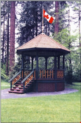
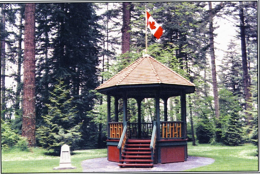
Reconstructed Central Park Bandstand
https://search.heritageburnaby.ca/link/archivedescription58424
- Repository
- City of Burnaby Archives
- Date
- 1996
- Collection/Fonds
- Burnaby Historical Society fonds
- Description Level
- Item
- Physical Description
- 1 photographic postcard : col.
- Scope and Content
- Photographic postcard of the reconstructed Central Park Bandstand used to promote its official opening taking place May 29, 1996 (to be described).
- Repository
- City of Burnaby Archives
- Date
- 1996
- Collection/Fonds
- Burnaby Historical Society fonds
- Subseries
- Pixie McGeachie subseries
- Physical Description
- 1 photographic postcard : col.
- Description Level
- Item
- Record No.
- 332-002
- Access Restriction
- No restrictions
- Reproduction Restriction
- No restrictions
- Accession Number
- BHS1996-16
- Scope and Content
- Photographic postcard of the reconstructed Central Park Bandstand used to promote its official opening taking place May 29, 1996 (to be described).
- Media Type
- Photograph
- Geographic Access
- Central Park
- Imperial Street
- Street Address
- 3883 Imperial Street
- Historic Neighbourhood
- Central Park (Historic Neighbourhood)
- Planning Study Area
- Maywood Area
Images
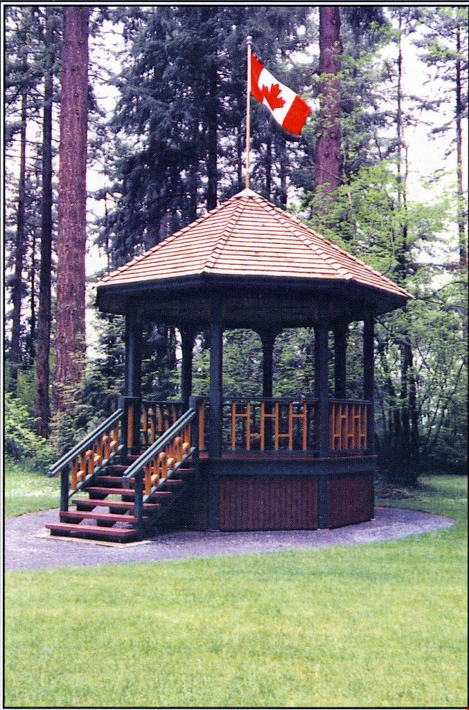
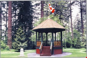
Reconstructed Central Park Bandstand
https://search.heritageburnaby.ca/link/archivedescription58425
- Repository
- City of Burnaby Archives
- Date
- 1996
- Collection/Fonds
- Burnaby Historical Society fonds
- Description Level
- Item
- Physical Description
- 1 photographic postcard : col.
- Scope and Content
- Photographic postcard of the reconstructed Central Park Bandstand used to promote its official opening taking place May 29, 1996.
- Repository
- City of Burnaby Archives
- Date
- 1996
- Collection/Fonds
- Burnaby Historical Society fonds
- Subseries
- Pixie McGeachie subseries
- Physical Description
- 1 photographic postcard : col.
- Description Level
- Item
- Record No.
- 332-003
- Access Restriction
- No restrictions
- Reproduction Restriction
- Reproduce for fair dealing purposes only
- Accession Number
- BHS1996-16
- Scope and Content
- Photographic postcard of the reconstructed Central Park Bandstand used to promote its official opening taking place May 29, 1996.
- Media Type
- Photograph
- Geographic Access
- Central Park
- Imperial Street
- Street Address
- 3883 Imperial Street
- Historic Neighbourhood
- Central Park (Historic Neighbourhood)
- Planning Study Area
- Maywood Area
Images
7365 CA Way Burnaby
https://search.heritageburnaby.ca/link/archivedescription94310
- Repository
- City of Burnaby Archives
- Date
- May 1994
- Collection/Fonds
- Grover, Elliott & Co. Ltd. fonds
- Description Level
- File
- Physical Description
- 40 photographs : col. negatives ; 35 mm
- Scope and Content
- Photographs of low-rise apartments and single-family homes along the 7300 block of Canaday Way, including a two-storey apartment complex at 7365 Canada Way.
- Repository
- City of Burnaby Archives
- Date
- May 1994
- Collection/Fonds
- Grover, Elliott & Co. Ltd. fonds
- Physical Description
- 40 photographs : col. negatives ; 35 mm
- Description Level
- File
- Record No.
- 622-095
- Access Restriction
- No restrictions
- Reproduction Restriction
- No restrictions
- Accession Number
- 2017-39
- Scope and Content
- Photographs of low-rise apartments and single-family homes along the 7300 block of Canaday Way, including a two-storey apartment complex at 7365 Canada Way.
- Media Type
- Photograph
- Notes
- Transcribed title
- Title transcribed from envelope photographs were originally housed in
- File no. 94-181-B
- Photographer identified as "L.D."
- Geographic Access
- Canada Way
- Street Address
- 7365 Canada Way
- Historic Neighbourhood
- Edmonds (Historic Neighbourhood)
- Planning Study Area
- Edmonds Area

New Vista Society Project
https://search.heritageburnaby.ca/link/archivedescription34649
- Repository
- City of Burnaby Archives
- Date
- 1954
- Collection/Fonds
- Burnaby Historical Society fonds
- Description Level
- Item
- Physical Description
- 1 photograph : b&w ; 19.9 x 25.5 cm
- Scope and Content
- Photograph of the New Vista Society housing project no. 6 at 141-149-155 11th Avenue (later renumbered the 8100 block of 11th Avenue).
- Repository
- City of Burnaby Archives
- Date
- 1954
- Collection/Fonds
- Burnaby Historical Society fonds
- Subseries
- Photographs subseries
- Physical Description
- 1 photograph : b&w ; 19.9 x 25.5 cm
- Description Level
- Item
- Record No.
- 080-004
- Access Restriction
- No restrictions
- Reproduction Restriction
- Reproduce for fair dealing purposes only
- Accession Number
- BHS2007-04
- Scope and Content
- Photograph of the New Vista Society housing project no. 6 at 141-149-155 11th Avenue (later renumbered the 8100 block of 11th Avenue).
- Names
- New Vista Society
- Media Type
- Photograph
- Photographer
- Stride, Charles Edgar
- Notes
- Title based on contents of photograph
- Caption at bottom left of photograph, "New Vista Society's Project #6. 141-149-155 11th Ave. East, South Burnaby, B.C., 1954"
- Stamp and annotation on back of photograph reads, "Photo by The Stride Studios / 657 Columbia Street, New Westminster, BC" and "#7071-A"
- Geographic Access
- 11th Avenue
- Historic Neighbourhood
- East Burnaby (Historic Neighbourhood)
- Planning Study Area
- Second Street Area
Images


Three Apartment Blocks
https://search.heritageburnaby.ca/link/archivedescription64659
- Repository
- City of Burnaby Archives
- Date
- 1954
- Collection/Fonds
- Ernest Winch fonds
- Description Level
- Item
- Physical Description
- 1 photograph : b&w postcard ; 8 x 13 cm
- Scope and Content
- Photographic postcard of the three apartment blocks at New Vista Society's Senior Citizens Housing Project no. 6 at 141-149-155 11th Avenue (later renumbered the 8100 block of 11th Avenue).
- Repository
- City of Burnaby Archives
- Date
- 1954
- Collection/Fonds
- Ernest Winch fonds
- Physical Description
- 1 photograph : b&w postcard ; 8 x 13 cm
- Description Level
- Item
- Record No.
- 514-008
- Access Restriction
- No restrictions
- Reproduction Restriction
- Reproduce for fair dealing purposes only
- Accession Number
- 2010-06
- Scope and Content
- Photographic postcard of the three apartment blocks at New Vista Society's Senior Citizens Housing Project no. 6 at 141-149-155 11th Avenue (later renumbered the 8100 block of 11th Avenue).
- Names
- New Vista Society
- Media Type
- Photograph
- Notes
- Transcribed title
- Photographer's note on recto of photograph reads: "Three Apartment Blocks / Senior Citizens Housing Project # 6 / Burnaby - B.C. - 1954"
- Geographic Access
- 11th Avenue
- Historic Neighbourhood
- East Burnaby (Historic Neighbourhood)
- Planning Study Area
- Second Street Area
Images

Love farmhouse conservation work files subseries
https://search.heritageburnaby.ca/link/museumdescription9805
- Repository
- Burnaby Village Museum
- Date
- 1988-2000, predominant 1993-1997
- Collection/Fonds
- Burnaby Village Museum fonds
- Description Level
- Subseries
- Scope and Content
- Subseries consists of conservation records pertaining to the acquistion, relocation, restoration, financing and preservation of the Love farmhouse at the Burnaby Village Museum. Records include copies of staff, department, commission, commitee and council reports; correspondence; research; budget s…
- Repository
- Burnaby Village Museum
- Collection/Fonds
- Burnaby Village Museum fonds
- Series
- Jesse Love farmhouse series
- Description Level
- Subseries
- Material Details
- 32 cm of textual records + approx. 29 architectural drawings + 1 drawing + 1 photograph : col. laser print + 3 photographs : photocopies, hand col.
- Scope and Content
- Subseries consists of conservation records pertaining to the acquistion, relocation, restoration, financing and preservation of the Love farmhouse at the Burnaby Village Museum. Records include copies of staff, department, commission, commitee and council reports; correspondence; research; budget summaries; interior and exterior plans; contract agreements; proposals; interior and exterior finishing treatments including tin ceilings, paint and wallpaper and drainage issues.
- Subjects
- Buildings - Heritage
- Documentary Artifacts - Architectural Drawings
- Buildings - Residential
- Accession Code
- BV018.41
- Access Restriction
- Subject to FIPPA
- Reproduction Restriction
- Reproductions subject to FIPPA
- Date
- 1988-2000, predominant 1993-1997
- Media Type
- Textual Record
- Architectural Drawing
- Notes
- Title based on content of subseries
![Burnaby Chamber of Commerce, [1959] thumbnail](/media/Hpo/_Data/_Archives_Images/_Unrestricted/001/115-001.jpg?width=280)
Burnaby Chamber of Commerce
https://search.heritageburnaby.ca/link/archivedescription34711
- Repository
- City of Burnaby Archives
- Date
- [1959]
- Collection/Fonds
- Burnaby Historical Society fonds
- Description Level
- Item
- Physical Description
- 1 photograph : b&w ; 18.1 x 21.9 cm
- Scope and Content
- Photograph of the "Yesterday and Today" display, Burnaby Chamber of Commerce. Signs on either side of the display read, "Burnaby has ten miles of Fraser River frontage" and "Burnaby has ten miles of deepsea frontage." In the centre is a display of photographs. Signs on both sides of the display …
- Repository
- City of Burnaby Archives
- Date
- [1959]
- Collection/Fonds
- Burnaby Historical Society fonds
- Subseries
- Photographs subseries
- Physical Description
- 1 photograph : b&w ; 18.1 x 21.9 cm
- Description Level
- Item
- Record No.
- 115-001
- Access Restriction
- No restrictions
- Reproduction Restriction
- Reproduce for fair dealing purposes only
- Accession Number
- BHS2007-04
- Scope and Content
- Photograph of the "Yesterday and Today" display, Burnaby Chamber of Commerce. Signs on either side of the display read, "Burnaby has ten miles of Fraser River frontage" and "Burnaby has ten miles of deepsea frontage." In the centre is a display of photographs. Signs on both sides of the display read, "'Burnaby Yesterday and Today!' / Photo display by Burnaby Historical Society."
- Subjects
- Advertising Medium - Signs and Signboards
- Organizations
- Documentary Artifacts - Photographs
- Media Type
- Photograph
- Photographer
- Bower, Ralph
- Notes
- Title based on contents of photograph
- Stamped on back of photograph, "Photography by Ralph Bower"
Images
![Burnaby Chamber of Commerce, [1959] thumbnail](/media/Hpo/_Data/_Archives_Images/_Unrestricted/001/115-001.jpg)