More like 'Gilmore Avenue School'
Narrow Results By
Subject
- Advertising Medium 2
- Advertising Medium - Signs and Signboards 11
- Aerial Photographs 8
- Agriculture - Farms 16
- Agriculture - Fruit and Berries 1
- Animals - Horses 1
- Arts - Paintings 4
- Arts - Sculptures 3
- Buildings - Agricultural 1
- Buildings - Agricultural - Barns 7
- Buildings - Agricultural - Greenhouses 5
- Buildings - Agricultural - Nurseries 1

The Benedictines of Westminster Priory
https://search.heritageburnaby.ca/link/archivedescription38167
- Repository
- City of Burnaby Archives
- Date
- 1951 (date of original), copied 1991
- Collection/Fonds
- Burnaby Historical Society fonds
- Description Level
- Item
- Physical Description
- 1 photograph : b&w ; 3.3 x 5.3 cm print on contact sheet 20.1 x 26.3 cm
- Scope and Content
- Photograph of an original photographic postcard of the Benedictines of Westminster Priory at Ceperley House which was funded by the Catholic Diocese beginning in 1939. There is a postmark from Merritt, British Columbia, at the top right corner.
- Repository
- City of Burnaby Archives
- Date
- 1951 (date of original), copied 1991
- Collection/Fonds
- Burnaby Historical Society fonds
- Subseries
- Burnaby Image Bank subseries
- Physical Description
- 1 photograph : b&w ; 3.3 x 5.3 cm print on contact sheet 20.1 x 26.3 cm
- Description Level
- Item
- Record No.
- 370-754
- Access Restriction
- No restrictions
- Reproduction Restriction
- No restrictions
- Accession Number
- BHS1999-03
- Scope and Content
- Photograph of an original photographic postcard of the Benedictines of Westminster Priory at Ceperley House which was funded by the Catholic Diocese beginning in 1939. There is a postmark from Merritt, British Columbia, at the top right corner.
- Subjects
- Buildings - Religious
- Buildings - Heritage
- Occupations - Clergy
- Documentary Artifacts - Postcards
- Names
- Westminster Priory
- Media Type
- Photograph
- Notes
- 1 b&w copy negative accompanying
- Negative has a pink cast
- Annotation at bottom of photograph reads, "The Benedictines of Westminster Priory, Vancouver, BC"
- Geographic Access
- Deer Lake Avenue
- Street Address
- 6344 Deer Lake Avenue
- Historic Neighbourhood
- Burnaby Lake (Historic Neighbourhood)
- Planning Study Area
- Douglas-Gilpin Area
Images

![Haida Grill at the Astor Hotel, [between 1955 and 1959] thumbnail](/media/hpo/_Data/_Archives_Images/_Unrestricted/316/327-001.jpg?width=280)
Haida Grill at the Astor Hotel
https://search.heritageburnaby.ca/link/archivedescription37173
- Repository
- City of Burnaby Archives
- Date
- [between 1955 and 1959]
- Collection/Fonds
- Burnaby Historical Society fonds
- Description Level
- Item
- Physical Description
- 1 postcard ; col. ; 8 x 13 cm
- Scope and Content
- Postcard with a photograph of the Haida Grill at the Astor Hotel, which was known as being Burnaby's million dollar, ultra-modern hotel.
- Repository
- City of Burnaby Archives
- Date
- [between 1955 and 1959]
- Collection/Fonds
- Burnaby Historical Society fonds
- Subseries
- Lee Lightfoot subseries
- Physical Description
- 1 postcard ; col. ; 8 x 13 cm
- Description Level
- Item
- Record No.
- 327-001
- Access Restriction
- No restrictions
- Reproduction Restriction
- Reproduce for fair dealing purposes only
- Accession Number
- BHS1996-13
- Scope and Content
- Postcard with a photograph of the Haida Grill at the Astor Hotel, which was known as being Burnaby's million dollar, ultra-modern hotel.
- Subjects
- Buildings - Commercial - Hotels and Motels
- Buildings - Commercial - Restaurants
- Documentary Artifacts - Postcards
- Names
- Astor Hotel
- Media Type
- Photograph
- Notes
- Title based on contents of photograph
- Caption on recto of postcard reads: "ASTOR HOTEL . 4561 KINGSWAY, BURNABY 1, B.C."
- Caption on verso of postcard reads: "THE HAIDA GRILL/ The delightful setting and excellent cuisine makes the Haida Grill a must for dining pleasure. A Photograph [sic] showing the Haida Grill with its table side service."
- Geographic Access
- Kingsway
- Street Address
- 4561 Kingsway
- Historic Neighbourhood
- Central Park (Historic Neighbourhood)
- Planning Study Area
- Marlborough Area
Images
![Haida Grill at the Astor Hotel, [between 1955 and 1959] thumbnail](/media/hpo/_Data/_Archives_Images/_Unrestricted/316/327-001.jpg)
![Blue Haven Motel, [195-] thumbnail](/media/hpo/_Data/_Archives_Images/_Unrestricted/126/199-001.jpg?width=280)
Blue Haven Motel
https://search.heritageburnaby.ca/link/archivedescription35136
- Repository
- City of Burnaby Archives
- Date
- [195-]
- Collection/Fonds
- Burnaby Historical Society fonds
- Description Level
- Item
- Physical Description
- 1 photograph : col. postcard ; 8.9 x 13.9 cm
- Scope and Content
- Photographic postcard of the Blue Haven Motel, 7026 Kingsway. The description printed on the back of the postcard reads, "Blue Haven Motel / 7026 Kingsway, South Burnaby, B.C., Canada / Mrgs.: Mr. and Mrs. A. Pearson / 22 Units - 4 Stars - AAA - ACRA / T.V. Equipped / Telephone LA 1-9942." The bui…
- Repository
- City of Burnaby Archives
- Date
- [195-]
- Collection/Fonds
- Burnaby Historical Society fonds
- Subseries
- Photographs subseries
- Physical Description
- 1 photograph : col. postcard ; 8.9 x 13.9 cm
- Description Level
- Item
- Record No.
- 199-001
- Access Restriction
- No restrictions
- Reproduction Restriction
- Reproduce for fair dealing purposes only
- Accession Number
- BHS1987-10
- Scope and Content
- Photographic postcard of the Blue Haven Motel, 7026 Kingsway. The description printed on the back of the postcard reads, "Blue Haven Motel / 7026 Kingsway, South Burnaby, B.C., Canada / Mrgs.: Mr. and Mrs. A. Pearson / 22 Units - 4 Stars - AAA - ACRA / T.V. Equipped / Telephone LA 1-9942." The building on the left side of the photograph has "Office" written on the door. Cars and motel units are seen at the right.
- Names
- Blue Haven Motel
- Media Type
- Photograph
- Responsibility
- Printed on back of postcard: "Traveltime product. Made in Vancouver, Canada, by Grant-Mann Lithographers, Ltd."
- Notes
- Title based on contents of photograph
- Geographic Access
- Kingsway
- Street Address
- 7026 Kingsway
- Historic Neighbourhood
- Edmonds (Historic Neighbourhood)
- Planning Study Area
- Stride Avenue Area
Images
![Blue Haven Motel, [195-] thumbnail](/media/hpo/_Data/_Archives_Images/_Unrestricted/126/199-001.jpg)
![The Fair Haven, [between 1950 and 1957] thumbnail](/media/Hpo/_Data/_Archives_Images/_Unrestricted/251/305-001.jpg?width=280)
The Fair Haven
https://search.heritageburnaby.ca/link/archivedescription36597
- Repository
- City of Burnaby Archives
- Date
- [between 1950 and 1957]
- Collection/Fonds
- Burnaby Historical Society fonds
- Description Level
- Item
- Physical Description
- 1 photograph : col. postcard ; 9 x 14 cm
- Scope and Content
- Aerial photographic postcard of "the Fair Haven," a group of United Church homes for Senior Citizens. The road in the foreground is Rumble Street, and the long road to the right is Sussex Avenue. The small forest behind "the Fair Haven" is the David Gary Park.
- Repository
- City of Burnaby Archives
- Date
- [between 1950 and 1957]
- Collection/Fonds
- Burnaby Historical Society fonds
- Subseries
- Vera Jackson Pel subseries
- Physical Description
- 1 photograph : col. postcard ; 9 x 14 cm
- Description Level
- Item
- Record No.
- 305-001
- Access Restriction
- No restrictions
- Reproduction Restriction
- Reproduce for fair dealing purposes only
- Accession Number
- BHS1992-46
- Scope and Content
- Aerial photographic postcard of "the Fair Haven," a group of United Church homes for Senior Citizens. The road in the foreground is Rumble Street, and the long road to the right is Sussex Avenue. The small forest behind "the Fair Haven" is the David Gary Park.
- Subjects
- Aerial Photographs
- Documentary Artifacts - Postcards
- Buildings - Residential - Seniors Housing
- Names
- Fair Haven
- Media Type
- Photograph
- Notes
- Typewritten note on verso of postcard reads: "AERIAL VIEW/ 'The Fairhaven', Burnaby BC / United Church Homes for Senior Citizens / 4341 Rumble St., Burnaby, BC"
- Handwritten note on verso of postcard reads: ""The road in the foreground is Rumble Street. The long road to the right is Sussex Avenue. The road, going up, on the left, barely visible is McKay Avenue = lower corner. Behind Fair Haven is the future David Gary Park cleared in the late 1950's - then more trees were felled in October 1962 with Hurricane Freda (blown over, uprooted trees) that left the park as it is today in 1993. The top row of little (5) white cottages were moved from the N.W. corner of Willingdon and Kingsway where Old Orchard Mall is now - they were part of Old Orchard Auto Villas, the first Fair Havens. Note: All cottages on right side of Lodge have been moved to Vancouver Island in 1991 for Motel units - by barge."
- Printed on verso of postcard: "Traveltime product, made in Vancouver, Canada, by Grant-Mann Lithographers Ltd."
- Geographic Access
- Rumble Street
- Street Address
- 4341 Rumble Street
- Historic Neighbourhood
- Alta-Vista (Historic Neighbourhood)
- Planning Study Area
- Sussex-Nelson Area
Images
![The Fair Haven, [between 1950 and 1957] thumbnail](/media/Hpo/_Data/_Archives_Images/_Unrestricted/251/305-001.jpg)
![George Derby Health Centre, [between 1950 and 1954] (date of original), copied 1991 thumbnail](/media/hpo/_Data/_Archives_Images/_Unrestricted/370/370-121.jpg?width=280)
George Derby Health Centre
https://search.heritageburnaby.ca/link/archivedescription37533
- Repository
- City of Burnaby Archives
- Date
- [between 1950 and 1954] (date of original), copied 1991
- Collection/Fonds
- Burnaby Historical Society fonds
- Description Level
- Item
- Physical Description
- 1 photograph : b&w ; 2.5 x 4.1 cm print on contact sheet 20.2 x 25.3 cm
- Scope and Content
- Photograph of the George Derby Health Centre which includes the main building, parking lot and grounds.
- Repository
- City of Burnaby Archives
- Date
- [between 1950 and 1954] (date of original), copied 1991
- Collection/Fonds
- Burnaby Historical Society fonds
- Subseries
- Burnaby Image Bank subseries
- Physical Description
- 1 photograph : b&w ; 2.5 x 4.1 cm print on contact sheet 20.2 x 25.3 cm
- Description Level
- Item
- Record No.
- 370-121
- Access Restriction
- No restrictions
- Reproduction Restriction
- No restrictions
- Accession Number
- BHS1999-03
- Scope and Content
- Photograph of the George Derby Health Centre which includes the main building, parking lot and grounds.
- Subjects
- Geographic Features - Automobile Parking Lots
- Buildings - Civic - Hospitals
- Documentary Artifacts - Postcards
- Media Type
- Photograph
- Notes
- Title based on caption on photograph
- 1 b&w copy negative accompanying
- Print was copied from a postcard original
- Caption at bottom of photograph reads, "George Derby Health Centre / Burnaby B.C."
- Geographic Access
- Cumberland Street
- Street Address
- 7550 Cumberland Street
- Historic Neighbourhood
- East Burnaby (Historic Neighbourhood)
- Planning Study Area
- Cariboo-Armstrong Area
Images
![George Derby Health Centre, [between 1950 and 1954] (date of original), copied 1991 thumbnail](/media/hpo/_Data/_Archives_Images/_Unrestricted/370/370-121.jpg)
![George Derby Health Centre, [between 1950 and 1954] (date of original), copied 1991 thumbnail](/media/hpo/_Data/_Archives_Images/_Unrestricted/370/370-127.jpg?width=280)
George Derby Health Centre
https://search.heritageburnaby.ca/link/archivedescription37539
- Repository
- City of Burnaby Archives
- Date
- [between 1950 and 1954] (date of original), copied 1991
- Collection/Fonds
- Burnaby Historical Society fonds
- Description Level
- Item
- Physical Description
- 1 photograph : b&w ; 3.4 x 5.0 cm print on contact sheet 20.2 x 25.3 cm
- Scope and Content
- Aerial photograph of the George Derby Health Centre, copied from a postcard.
- Repository
- City of Burnaby Archives
- Date
- [between 1950 and 1954] (date of original), copied 1991
- Collection/Fonds
- Burnaby Historical Society fonds
- Subseries
- Burnaby Image Bank subseries
- Physical Description
- 1 photograph : b&w ; 3.4 x 5.0 cm print on contact sheet 20.2 x 25.3 cm
- Description Level
- Item
- Record No.
- 370-127
- Access Restriction
- No restrictions
- Reproduction Restriction
- No restrictions
- Accession Number
- BHS1999-03
- Scope and Content
- Aerial photograph of the George Derby Health Centre, copied from a postcard.
- Media Type
- Photograph
- Notes
- Title based on caption on photograph
- 1 b&w copy negative accompanying
- Caption on photograph reads, "George Derby Health Centre, Burnaby B.C."
- Geographic Access
- Cumberland Street
- Street Address
- 7550 Cumberland Street
- Historic Neighbourhood
- East Burnaby (Historic Neighbourhood)
- Planning Study Area
- Cariboo-Armstrong Area
Images
![George Derby Health Centre, [between 1950 and 1954] (date of original), copied 1991 thumbnail](/media/hpo/_Data/_Archives_Images/_Unrestricted/370/370-127.jpg)
![Hotel Burnaby, [1953] thumbnail](/media/hpo/_Data/_Archives_Images/_Unrestricted/371/410-001.jpg?width=280)
Hotel Burnaby
https://search.heritageburnaby.ca/link/archivedescription38341
- Repository
- City of Burnaby Archives
- Date
- [1953]
- Collection/Fonds
- Burnaby Historical Society fonds
- Description Level
- Item
- Physical Description
- 1 photograph : b&w postcard ; 8.7 x 13.1 cm
- Scope and Content
- Photographic postcard advertising the Hotel Burnaby at 1385 Kingsway (old street numbering). A caption on the reverse of the postcard reads: Hotel Burnaby / :Located between new Simpsons-Sears and new Woodwards shopping centres / You will remember Hotel Burnaby for the REST of your life."
- Repository
- City of Burnaby Archives
- Date
- [1953]
- Collection/Fonds
- Burnaby Historical Society fonds
- Subseries
- Jim Wolf subseries
- Physical Description
- 1 photograph : b&w postcard ; 8.7 x 13.1 cm
- Description Level
- Item
- Record No.
- 410-001
- Access Restriction
- No restrictions
- Reproduction Restriction
- Reproduce for fair dealing purposes only
- Accession Number
- BHS2000-11
- Scope and Content
- Photographic postcard advertising the Hotel Burnaby at 1385 Kingsway (old street numbering). A caption on the reverse of the postcard reads: Hotel Burnaby / :Located between new Simpsons-Sears and new Woodwards shopping centres / You will remember Hotel Burnaby for the REST of your life."
- Subjects
- Advertising Medium
- Documentary Artifacts - Postcards
- Buildings - Commercial - Hotels and Motels
- Names
- Hotel Burnaby Limited
- Media Type
- Photograph
- Notes
- Title based on contents of photograph
- Geographic Access
- Kingsway
- Historic Neighbourhood
- Edmonds (Historic Neighbourhood)
- Planning Study Area
- Stride Avenue Area
Images
![Hotel Burnaby, [1953] thumbnail](/media/hpo/_Data/_Archives_Images/_Unrestricted/371/410-001.jpg)
![Hotel Burnaby Ltd., [1955] thumbnail](/media/hpo/_Data/_Archives_Images/_Unrestricted/371/474-001.jpg?width=280)
Hotel Burnaby Ltd.
https://search.heritageburnaby.ca/link/archivedescription38656
- Repository
- City of Burnaby Archives
- Date
- [1955]
- Collection/Fonds
- Burnaby Historical Society fonds
- Description Level
- Item
- Physical Description
- 1 photograph : col. postcard ; 9 x 14 cm
- Scope and Content
- Photographic postcard of Burnaby Hotel located at 1385 Kingsway (old street numbering system). Printed at the bottom of the postcard is the following: Hotel Burnaby Ltd. / 1385 Kingsway at 14th Avenue / Burnaby 3, New Westminster, B.C., Telephone LA 1-8891. On the reverse is written: "Hotel Burna…
- Repository
- City of Burnaby Archives
- Date
- [1955]
- Collection/Fonds
- Burnaby Historical Society fonds
- Subseries
- Jim Wolf subseries
- Physical Description
- 1 photograph : col. postcard ; 9 x 14 cm
- Description Level
- Item
- Record No.
- 474-001
- Access Restriction
- No restrictions
- Reproduction Restriction
- Reproduce for fair dealing purposes only
- Accession Number
- BHS2005-6
- Scope and Content
- Photographic postcard of Burnaby Hotel located at 1385 Kingsway (old street numbering system). Printed at the bottom of the postcard is the following: Hotel Burnaby Ltd. / 1385 Kingsway at 14th Avenue / Burnaby 3, New Westminster, B.C., Telephone LA 1-8891. On the reverse is written: "Hotel Burnaby: Located between new Simpson-Sears and new Woodwards shopping centres. You will remember Hotel Burnaby for the rest of your life."
- Subjects
- Buildings - Commercial - Hotels and Motels
- Documentary Artifacts - Postcards
- Advertising Medium
- Names
- Hotel Burnaby Limited
- Media Type
- Photograph
- Photographer
- Grant-Mann Lithographers Limited
- Notes
- Title based on caption of postcard
- Made by Grant-Mann Lithographers Ltd. "Colour Card" Division, Vancouver British Columbia
- Geographic Access
- Kingsway
- Historic Neighbourhood
- Edmonds (Historic Neighbourhood)
- Planning Study Area
- Stride Avenue Area
Images
![Hotel Burnaby Ltd., [1955] thumbnail](/media/hpo/_Data/_Archives_Images/_Unrestricted/371/474-001.jpg)
![School room at Oakalla, [195-] (date of original), copied 1991 thumbnail](/media/hpo/_Data/_Archives_Images/_Unrestricted/370/370-733.jpg?width=280)
School room at Oakalla
https://search.heritageburnaby.ca/link/archivedescription38146
- Repository
- City of Burnaby Archives
- Date
- [195-] (date of original), copied 1991
- Collection/Fonds
- Burnaby Historical Society fonds
- Description Level
- Item
- Physical Description
- 1 photograph : b&w ; 3.6 x 4.4 cm print on contact sheet 20.6 x 26.8 cm
- Scope and Content
- Photograph of the interior of a school room at Oakalla Prison Farm. Men are seated at desks, and a student and teacher are at the blackboard standing beside a map. A list of words is on the blackboard.
- Repository
- City of Burnaby Archives
- Date
- [195-] (date of original), copied 1991
- Collection/Fonds
- Burnaby Historical Society fonds
- Subseries
- Burnaby Image Bank subseries
- Physical Description
- 1 photograph : b&w ; 3.6 x 4.4 cm print on contact sheet 20.6 x 26.8 cm
- Description Level
- Item
- Record No.
- 370-733
- Access Restriction
- No restrictions
- Reproduction Restriction
- Reproduce for fair dealing purposes only
- Accession Number
- BHS1999-03
- Scope and Content
- Photograph of the interior of a school room at Oakalla Prison Farm. Men are seated at desks, and a student and teacher are at the blackboard standing beside a map. A list of words is on the blackboard.
- Subjects
- Documentary Artifacts - Maps
- Buildings - Public - Detention Facilities
- Buildings - Schools
- Occupations - Teachers
- Names
- Oakalla Prison Farm
- Media Type
- Photograph
- Notes
- Title based on contents of photograph
- 1 b&w copy negative accompanying
- Negative has a pink cast
- Geographic Access
- Oakmount Crescent
- Street Address
- 5220 Oakmount Crescent
- Historic Neighbourhood
- Burnaby Lake (Historic Neighbourhood)
- Planning Study Area
- Oakalla Area
Images
![School room at Oakalla, [195-] (date of original), copied 1991 thumbnail](/media/hpo/_Data/_Archives_Images/_Unrestricted/370/370-733.jpg)
![Story time, [between 1957 and 1968] thumbnail](/media/hpo/_Data/_Archives_Images/_Unrestricted/205/246-008.jpg?width=280)
Story time
https://search.heritageburnaby.ca/link/archivedescription52968
- Repository
- City of Burnaby Archives
- Date
- [between 1957 and 1968]
- Collection/Fonds
- Burnaby Historical Society fonds
- Description Level
- Item
- Physical Description
- 1 photograph : col. ; 7.5 x 7.5 cm
- Scope and Content
- Photograph of the Tinkerbell Kindergarten class sitting in their classroom in small wooden chairs, with the front row sitting on the carpet, for "story time". One child stands up and points to the book as the adult reading leans in and listens to his comment as she holds the book up for everyone to…
- Repository
- City of Burnaby Archives
- Date
- [between 1957 and 1968]
- Collection/Fonds
- Burnaby Historical Society fonds
- Subseries
- Tinkerbell Kindergarten subseries
- Physical Description
- 1 photograph : col. ; 7.5 x 7.5 cm
- Description Level
- Item
- Record No.
- 246-008
- Access Restriction
- No restrictions
- Reproduction Restriction
- Reproduce for fair dealing purposes only
- Accession Number
- BHS1990-12
- Scope and Content
- Photograph of the Tinkerbell Kindergarten class sitting in their classroom in small wooden chairs, with the front row sitting on the carpet, for "story time". One child stands up and points to the book as the adult reading leans in and listens to his comment as she holds the book up for everyone to see.
- Media Type
- Photograph
- Notes
- Title based on contents of photograph
- Geographic Access
- Ellesmere Avenue
- Hastings Street
- Street Address
- 300 Ellesmere Avenue North
- Historic Neighbourhood
- Capitol Hill (Historic Neighbourhood)
- Planning Study Area
- Capitol Hill Area
Images
![Story time, [between 1957 and 1968] thumbnail](/media/hpo/_Data/_Archives_Images/_Unrestricted/205/246-008.jpg)
Personal material
https://search.heritageburnaby.ca/link/archivedescription82732
- Repository
- City of Burnaby Archives
- Date
- [1910-1978]
- Collection/Fonds
- Hazel Simnett collection
- Description Level
- File
- Physical Description
- 9 paintings : colour print, 2 photographs : b&w, and 1 folder of textual records
- Scope and Content
- File consists of application for a driver's license, Kingsway Driving School report card, driver's examination receipt and a letter addressed to Hazel Simnett from the Victorian Order of Nurses for Canada. Also included is an immigration inspection card of Fred Simnett aboard the S.S. Lake Champlai…
- Repository
- City of Burnaby Archives
- Date
- [1910-1978]
- Collection/Fonds
- Hazel Simnett collection
- Physical Description
- 9 paintings : colour print, 2 photographs : b&w, and 1 folder of textual records
- Description Level
- File
- Record No.
- MSS167-008
- Accession Number
- 2013-22
- Scope and Content
- File consists of application for a driver's license, Kingsway Driving School report card, driver's examination receipt and a letter addressed to Hazel Simnett from the Victorian Order of Nurses for Canada. Also included is an immigration inspection card of Fred Simnett aboard the S.S. Lake Champlain from Liverpool and a letter from the Office of the Mayor addressed to Mary Ann Simnett for her ninetieth birthday. Also included is a photograph (see item 559-001). Also included are newsclippings regarding Robert Burnaby and the "Bygones of Burnaby" book, a programme of the Robert Burnaby Commemorative Dinner, a photocopy of "The Argus" (Burnaby South High School's newspaper) from 1938, a programme from Madys Pridmore Brown's Variety Programme, "The Buzzer" Volume 40 Issue 16 advertising Vancouver street cars, New Vista Society certificate addressed to Hazel Simnett, an envelope of Fenwick Lansdowne bird prints from 1957 and a print of the Royal Family found in a cardboard envelope postmarked 1972.
- Subjects
- Arts - Paintings
- Documentary Artifacts - Newspapers
- Documentary Artifacts - Photographs
- Performances - Concerts
- Organizations - Societies and Clubs
- Personal Symbols - Certificates
- Transportation
- Persons - Royalty
- Media Type
- Textual Record
- Photograph
- Graphic Material
- Notes
- Title based on note accompanying file on folder ; The Argue was stapled together
- Simnett personal papers series
- Historic Neighbourhood
- Alta-Vista (Historic Neighbourhood)
- Planning Study Area
- Clinton-Glenwood Area
![Bonsor Hall, [1958] thumbnail](/media/Hpo/_Data/_Archives_Images/_Unrestricted/316/345-003.jpg?width=280)
Bonsor Hall
https://search.heritageburnaby.ca/link/archivedescription37282
- Repository
- City of Burnaby Archives
- Date
- [1958]
- Collection/Fonds
- Burnaby Historical Society fonds
- Description Level
- Item
- Physical Description
- 1 photograph : b&w ; 9 x 9 cm
- Scope and Content
- Photograph of the Bonsor Hall (formerly the Kingsway West School). A note on the back of the photograph reads: "The Old Bonsor Hall - Formerly Kingsway W. School as in Burnaby Courier." The photograph was taken by the Burnaby Courier newspaper ca. 1958.
- Repository
- City of Burnaby Archives
- Date
- [1958]
- Collection/Fonds
- Burnaby Historical Society fonds
- Subseries
- Norah Code subseries
- Physical Description
- 1 photograph : b&w ; 9 x 9 cm
- Description Level
- Item
- Record No.
- 345-003
- Access Restriction
- No restrictions
- Reproduction Restriction
- Reproduce for fair dealing purposes only
- Accession Number
- BHS1997-05
- Scope and Content
- Photograph of the Bonsor Hall (formerly the Kingsway West School). A note on the back of the photograph reads: "The Old Bonsor Hall - Formerly Kingsway W. School as in Burnaby Courier." The photograph was taken by the Burnaby Courier newspaper ca. 1958.
- Names
- Bonsor Hall
- Media Type
- Photograph
- Photographer
- Code, Norah
- Notes
- Title based on caption.
- Photographs in this collection were taken and compiled by Norah Code, former editor of the "Burnaby Courier" newspaper during the course of her work for the newspaper.
- Geographic Access
- Kingsway
- Street Address
- 4800 Kingsway
- Historic Neighbourhood
- Central Park (Historic Neighbourhood)
- Planning Study Area
- Maywood Area
Images
![Bonsor Hall, [1958] thumbnail](/media/Hpo/_Data/_Archives_Images/_Unrestricted/316/345-003.jpg)

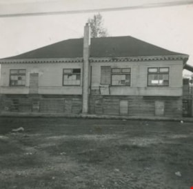
Extension of McPherson Park School
https://search.heritageburnaby.ca/link/archivedescription36489
- Repository
- City of Burnaby Archives
- Date
- September 1959
- Collection/Fonds
- Burnaby Historical Society fonds
- Description Level
- Item
- Physical Description
- 1 photograph : b&w ; 8.5 x 12.5 cm print
- Scope and Content
- Photograph of the A.J. Keel house with excavation for the extension of the McPherson Park School.
- Repository
- City of Burnaby Archives
- Date
- September 1959
- Collection/Fonds
- Burnaby Historical Society fonds
- Subseries
- Keel family subseries
- Physical Description
- 1 photograph : b&w ; 8.5 x 12.5 cm print
- Description Level
- Item
- Record No.
- 279-002
- Access Restriction
- No restrictions
- Reproduction Restriction
- Reproduce for fair dealing purposes only
- Accession Number
- BHS1992-09
- Scope and Content
- Photograph of the A.J. Keel house with excavation for the extension of the McPherson Park School.
- Names
- McPherson Park School
- Media Type
- Photograph
- Notes
- Title based on contents of photograph
- Geographic Access
- Rumble Street
- Historic Neighbourhood
- Alta-Vista (Historic Neighbourhood)
- Planning Study Area
- Clinton-Glenwood Area
Images


Extension of McPherson Park School
https://search.heritageburnaby.ca/link/archivedescription36490
- Repository
- City of Burnaby Archives
- Date
- September 1959
- Collection/Fonds
- Burnaby Historical Society fonds
- Description Level
- Item
- Physical Description
- 1 photograph : b&w ; 8.5 x 12.5 cm print
- Scope and Content
- Photograph of the A.J. Keel house with a close-up of the excavation for the extension of McPherson Park School.
- Repository
- City of Burnaby Archives
- Date
- September 1959
- Collection/Fonds
- Burnaby Historical Society fonds
- Subseries
- Keel family subseries
- Physical Description
- 1 photograph : b&w ; 8.5 x 12.5 cm print
- Description Level
- Item
- Record No.
- 279-003
- Access Restriction
- No restrictions
- Reproduction Restriction
- Reproduce for fair dealing purposes only
- Accession Number
- BHS1992-09
- Scope and Content
- Photograph of the A.J. Keel house with a close-up of the excavation for the extension of McPherson Park School.
- Names
- McPherson Park School
- Media Type
- Photograph
- Notes
- Title based on contents of photograph
- Geographic Access
- Rumble Street
- Historic Neighbourhood
- Alta-Vista (Historic Neighbourhood)
- Planning Study Area
- Clinton-Glenwood Area
Images

![Interior of schoolhouse, [198-] thumbnail](/media/hpo/_Data/_BVM_Images/2020/2020_0005_1592_001.jpg?width=280)
Interior of schoolhouse
https://search.heritageburnaby.ca/link/museumdescription14516
- Repository
- Burnaby Village Museum
- Date
- [198-]
- Collection/Fonds
- Century Park Museum Association fonds
- Description Level
- Item
- Physical Description
- 1 photograph : col. slide ; 35 mm
- Scope and Content
- Photograph of the interior of the Burnaby Village Museum schoolhouse. The interior is furnished with two rows of wooden desks, a book case, globe, teachers desk and black boards. The building was formerly the Elworth (Bateman) house garage before being moved and renovated as a schoolhouse in Herita…
- Repository
- Burnaby Village Museum
- Collection/Fonds
- Century Park Museum Association fonds
- Description Level
- Item
- Physical Description
- 1 photograph : col. slide ; 35 mm
- Scope and Content
- Photograph of the interior of the Burnaby Village Museum schoolhouse. The interior is furnished with two rows of wooden desks, a book case, globe, teachers desk and black boards. The building was formerly the Elworth (Bateman) house garage before being moved and renovated as a schoolhouse in Heritage Village.
- Subjects
- Buildings - Heritage
- Buildings - Schools
- Names
- Burnaby Village Museum
- Accession Code
- BV020.5.1592
- Access Restriction
- No restrictions
- Reproduction Restriction
- No known restrictions
- Date
- [198-]
- Media Type
- Photograph
- Scan Resolution
- 2400
- Scan Date
- 24-Nov-2020
- Scale
- 100
- Notes
- Title based on contents of photograph
Images
![Interior of schoolhouse, [198-] thumbnail](/media/hpo/_Data/_BVM_Images/2020/2020_0005_1592_001.jpg)
Old Bonsor Hall
https://search.heritageburnaby.ca/link/archivedescription37281
- Repository
- City of Burnaby Archives
- Date
- 1958
- Collection/Fonds
- Burnaby Historical Society fonds
- Description Level
- Item
- Physical Description
- 1 photograph : b&w ; 9 x 9 cm
- Scope and Content
- Photograph of the old Kingsway West school building which also served as the Bonsor Hall.
- Repository
- City of Burnaby Archives
- Date
- 1958
- Collection/Fonds
- Burnaby Historical Society fonds
- Subseries
- Norah Code subseries
- Physical Description
- 1 photograph : b&w ; 9 x 9 cm
- Description Level
- Item
- Record No.
- 345-002
- Access Restriction
- No restrictions
- Reproduction Restriction
- Reproduce for fair dealing purposes only
- Accession Number
- BHS1997-05
- Scope and Content
- Photograph of the old Kingsway West school building which also served as the Bonsor Hall.
- Media Type
- Photograph
- Photographer
- Code, Norah
- Notes
- Title based on contents of photograph
- Photographs in this collection were taken and compiled by Norah Code, former editor of the "Burnaby Courier" newspaper during the course of her work for the newspaper.
- Geographic Access
- Kingsway
- Street Address
- 4800 Kingsway
- Historic Neighbourhood
- Central Park (Historic Neighbourhood)
- Planning Study Area
- Maywood Area
Images


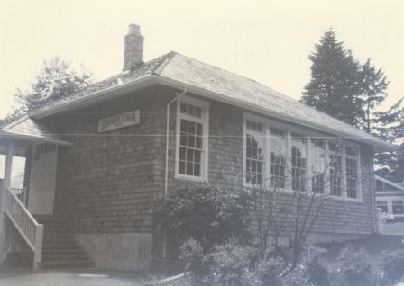
Seaforth School
https://search.heritageburnaby.ca/link/archivedescription38300
- Repository
- City of Burnaby Archives
- Date
- 1987
- Collection/Fonds
- Burnaby Historical Society fonds
- Description Level
- Item
- Physical Description
- 1 photograph : b&w ; 12.5 x 17.5 cm
- Scope and Content
- Photograph of the Seaforth School building which was originally built in the Lozells neighbourhood in North Burnaby in 1922. In 1983, the school was moved to its current site on the grounds of the Burnaby Village Museum and it remains a protected heritage building in Burnaby.
- Repository
- City of Burnaby Archives
- Date
- 1987
- Collection/Fonds
- Burnaby Historical Society fonds
- Subseries
- Photographs subseries
- Physical Description
- 1 photograph : b&w ; 12.5 x 17.5 cm
- Description Level
- Item
- Record No.
- 398-007
- Access Restriction
- No restrictions
- Reproduction Restriction
- Reproduce for fair dealing purposes only
- Accession Number
- BHS2007-04
- Scope and Content
- Photograph of the Seaforth School building which was originally built in the Lozells neighbourhood in North Burnaby in 1922. In 1983, the school was moved to its current site on the grounds of the Burnaby Village Museum and it remains a protected heritage building in Burnaby.
- Subjects
- Buildings - Heritage
- Buildings - Schools
- Names
- Seaforth School
- Media Type
- Photograph
- Notes
- Title based on contents of photograph.
- Geographic Access
- Deer Lake Avenue
- Street Address
- 6501 Deer Lake Avenue
- Historic Neighbourhood
- Burnaby Lake (Historic Neighbourhood)
- Planning Study Area
- Morley-Buckingham Area
Images
SFU Residence
https://search.heritageburnaby.ca/link/archivedescription93721
- Repository
- City of Burnaby Archives
- Date
- 1989
- Collection/Fonds
- Grover, Elliott & Co. Ltd. fonds
- Description Level
- File
- Physical Description
- 25 photographs : col. negatives ; 35 mm
- Scope and Content
- Photographs of the exteriors of four Simon Fraser University (SFU) residences: Shell House, Madge Hogarth House, Louis Riel House, and McTaggart-Cowan Hall
- Repository
- City of Burnaby Archives
- Date
- 1989
- Collection/Fonds
- Grover, Elliott & Co. Ltd. fonds
- Physical Description
- 25 photographs : col. negatives ; 35 mm
- Description Level
- File
- Record No.
- 622-010
- Access Restriction
- No restrictions
- Reproduction Restriction
- No restrictions
- Accession Number
- 2017-39
- Scope and Content
- Photographs of the exteriors of four Simon Fraser University (SFU) residences: Shell House, Madge Hogarth House, Louis Riel House, and McTaggart-Cowan Hall
- Names
- Simon Fraser University
- Media Type
- Photograph
- Notes
- Transcribed title
- Title transcribed from original print envelope
- Photographs 622-010-1 : 622-010-6 depict Madge Hogarth House
- Photographs 622-010-7 : 622-010-12 depict Shell House
- Photographs 622-010-13 : 622-010-15 and 622-010-19 : 622-010-21 depict Louis Riel Hous
- Photographs 622-010-16 : 622-010-18 and 622-010-22 : 622-010-25 depict McTaggart-Cowan Hall
- Residences were identified using notes on verso of accompanying prints
- Geographic Access
- Burnaby Mountain Conservation Area
- Planning Study Area
- Burnaby Mountain Area
![A group of children in a classroom decorating reindeer, [1982] thumbnail](/media/Hpo/_Data/_Archives_Images/_Unrestricted/480/480-1533.jpg?width=280)
A group of children in a classroom decorating reindeer
https://search.heritageburnaby.ca/link/archivedescription59218
- Repository
- City of Burnaby Archives
- Date
- [1982]
- Collection/Fonds
- Columbian Newspaper collection
- Description Level
- Item
- Physical Description
- 1 photograph : b&w ; 18.5 x 23.5 cm
- Scope and Content
- Photograph of children decorating papier-mâché reindeer in a classroom.
- Repository
- City of Burnaby Archives
- Date
- [1982]
- Collection/Fonds
- Columbian Newspaper collection
- Physical Description
- 1 photograph : b&w ; 18.5 x 23.5 cm
- Description Level
- Item
- Record No.
- 480-1533
- Access Restriction
- No restrictions
- Reproduction Restriction
- Reproduce for fair dealing purposes only
- Accession Number
- 2009-01
- Scope and Content
- Photograph of children decorating papier-mâché reindeer in a classroom.
- Subjects
- Buildings - Schools
- Crafts
- Media Type
- Photograph
- Notes
- Title based on contents of photograph
- Note on verso reads: "Reindeer / PMT 100% / page 5 / Burnaby Today"
Images
![A group of children in a classroom decorating reindeer, [1982] thumbnail](/media/Hpo/_Data/_Archives_Images/_Unrestricted/480/480-1533.jpg)
![Alpha Secondary School, [1950 or 1951] thumbnail](/media/hpo/_Data/_Archives_Images/_Unrestricted/370/370-813.jpg?width=280)
Alpha Secondary School
https://search.heritageburnaby.ca/link/archivedescription62709
- Repository
- City of Burnaby Archives
- Date
- [1950 or 1951]
- Collection/Fonds
- Burnaby Historical Society fonds
- Description Level
- Item
- Physical Description
- 1 photograph : b&w negative ; 5.5 x 7.5 cm
- Scope and Content
- Aerial photograph of Alpha Secondary School.
- Repository
- City of Burnaby Archives
- Date
- [1950 or 1951]
- Collection/Fonds
- Burnaby Historical Society fonds
- Subseries
- Burnaby Image Bank subseries
- Physical Description
- 1 photograph : b&w negative ; 5.5 x 7.5 cm
- Description Level
- Item
- Record No.
- 370-813
- Access Restriction
- No restrictions
- Reproduction Restriction
- Reproduce for fair dealing purposes only
- Accession Number
- BHS1999-03
- Scope and Content
- Aerial photograph of Alpha Secondary School.
- Subjects
- Aerial Photographs
- Buildings - Schools
- Names
- Alpha Secondary School
- Media Type
- Photograph
- Photographer
- Pride, A.H. "Harry"
- Notes
- Title based on contents of photograph
- 1 b&w original photograph accompanying
- Geographic Access
- Parker Street
- Street Address
- 4600 Parker Street
- Planning Study Area
- Brentwood Area
Images
![Alpha Secondary School, [1950 or 1951] thumbnail](/media/hpo/_Data/_Archives_Images/_Unrestricted/370/370-813.jpg)