Narrow Results By
Subject
- Advertising Medium - Signs and Signboards 2
- Aerial Photographs 10
- Buildings - Civic - City Halls 10
- Buildings - Civic - Hospitals 1
- Buildings - Civic - Museums 1
- Buildings - Commercial 1
- Buildings - Commercial - Banks 2
- Buildings - Commercial - Grocery Stores 3
- Buildings - Commercial - Restaurants 1
- Buildings - Commercial - Stores 2
- Buildings - Heritage 1
- Buildings - Industrial 2
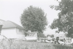
Demolition debris at Douglas Road School
https://search.heritageburnaby.ca/link/archivedescription38645
- Repository
- City of Burnaby Archives
- Date
- 1956
- Collection/Fonds
- Burnaby Historical Society fonds
- Description Level
- Item
- Physical Description
- 1 photograph : b&w ; 10 x 15 cm
- Scope and Content
- Photograph of demolition debris outside the Douglas Road School.
- Repository
- City of Burnaby Archives
- Date
- 1956
- Collection/Fonds
- Burnaby Historical Society fonds
- Subseries
- Douglas Road School subseries
- Physical Description
- 1 photograph : b&w ; 10 x 15 cm
- Description Level
- Item
- Record No.
- 471-006
- Access Restriction
- No restrictions
- Reproduction Restriction
- Reproduce for fair dealing purposes only
- Accession Number
- BHS2005-3
- Scope and Content
- Photograph of demolition debris outside the Douglas Road School.
- Subjects
- Buildings - Schools
- Construction
- Names
- Douglas Road School
- Media Type
- Photograph
- Photographer
- Gordon, Ethel
- Notes
- Title based on contents of photograph
- Geographic Access
- Canada Way
- Street Address
- 4861 Canada Way
- Historic Neighbourhood
- Burnaby Lake (Historic Neighbourhood)
- Planning Study Area
- Douglas-Gilpin Area
Images
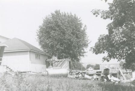
Douglas Road School
https://search.heritageburnaby.ca/link/archivedescription38642
- Repository
- City of Burnaby Archives
- Date
- 1956
- Collection/Fonds
- Burnaby Historical Society fonds
- Description Level
- Item
- Physical Description
- 1 photograph : b&w ; 10 x 10 cm
- Scope and Content
- Photograph of the partially demolished building at the Douglas Road School site.
- Repository
- City of Burnaby Archives
- Date
- 1956
- Collection/Fonds
- Burnaby Historical Society fonds
- Subseries
- Douglas Road School subseries
- Physical Description
- 1 photograph : b&w ; 10 x 10 cm
- Description Level
- Item
- Record No.
- 471-003
- Access Restriction
- No restrictions
- Reproduction Restriction
- Reproduce for fair dealing purposes only
- Accession Number
- BHS2005-3
- Scope and Content
- Photograph of the partially demolished building at the Douglas Road School site.
- Subjects
- Buildings - Schools
- Construction
- Names
- Douglas Road School
- Media Type
- Photograph
- Photographer
- Gordon, Ethel
- Notes
- Title based on contents of photograph.
- Geographic Access
- Canada Way
- Street Address
- 4861 Canada Way
- Historic Neighbourhood
- Burnaby Lake (Historic Neighbourhood)
- Planning Study Area
- Douglas-Gilpin Area
Images


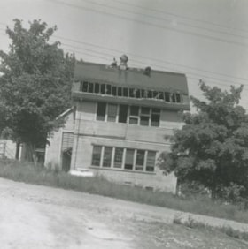
Douglas Road School renovation
https://search.heritageburnaby.ca/link/archivedescription38647
- Repository
- City of Burnaby Archives
- Date
- 1956
- Collection/Fonds
- Burnaby Historical Society fonds
- Description Level
- Item
- Physical Description
- 1 photograph : b&w ; 10 x 15 cm
- Scope and Content
- Photograph of a the Douglas Road school under renovations.
- Repository
- City of Burnaby Archives
- Date
- 1956
- Collection/Fonds
- Burnaby Historical Society fonds
- Subseries
- Douglas Road School subseries
- Physical Description
- 1 photograph : b&w ; 10 x 15 cm
- Description Level
- Item
- Record No.
- 471-008
- Access Restriction
- No restrictions
- Reproduction Restriction
- Reproduce for fair dealing purposes only
- Accession Number
- BHS2005-3
- Scope and Content
- Photograph of a the Douglas Road school under renovations.
- Subjects
- Construction
- Buildings - Schools
- Names
- Douglas Road School
- Media Type
- Photograph
- Photographer
- Gordon, Ethel
- Notes
- Title based on contents of photograph
- Geographic Access
- Canada Way
- Street Address
- 4861 Canada Way
- Historic Neighbourhood
- Burnaby Lake (Historic Neighbourhood)
- Planning Study Area
- Douglas-Gilpin Area
Images

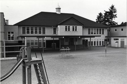
![Edmonds School trustees with architect and inspector, [between 1952 and 1956] thumbnail](/media/hpo/_Data/_Archives_Images/_Unrestricted/251/302-001.jpg?width=280)
Edmonds School trustees with architect and inspector
https://search.heritageburnaby.ca/link/archivedescription36578
- Repository
- City of Burnaby Archives
- Date
- [between 1952 and 1956]
- Collection/Fonds
- Burnaby Historical Society fonds
- Description Level
- Item
- Physical Description
- 1 photograph : sepia ; 19.5 x 24 cm
- Scope and Content
- Photograph of six men consulting blueprints outside in the snow at the site of the Edmonds Street School addition under construction. Standing in a row are;Trustee W. Maxwell, Architect Davies, Inspector Fredrickson, School Board Secretary Durkin, Trustee Samuel Norman Noble, and Principal Davis.
- Repository
- City of Burnaby Archives
- Date
- [between 1952 and 1956]
- Collection/Fonds
- Burnaby Historical Society fonds
- Subseries
- Photographs subseries
- Physical Description
- 1 photograph : sepia ; 19.5 x 24 cm
- Description Level
- Item
- Record No.
- 302-001
- Access Restriction
- No restrictions
- Reproduction Restriction
- Reproduce for fair dealing purposes only
- Accession Number
- BHS1992-43
- Scope and Content
- Photograph of six men consulting blueprints outside in the snow at the site of the Edmonds Street School addition under construction. Standing in a row are;Trustee W. Maxwell, Architect Davies, Inspector Fredrickson, School Board Secretary Durkin, Trustee Samuel Norman Noble, and Principal Davis.
- Subjects
- Buildings - Schools
- Construction
- Media Type
- Photograph
- Notes
- Title based on contents of photograph
- Handwritten note on verso of photograph identifies the individuals in the photograph and comments on them
- Copyright note: Images provided on this website are intended for research purposes only. Further use of any image is subject to the terms of the Copyright Act of Canada.
- Geographic Access
- 18th Avenue
- Street Address
- 7651 18th Avenue
- Historic Neighbourhood
- Edmonds (Historic Neighbourhood)
- Planning Study Area
- Edmonds Area
Images
![Edmonds School trustees with architect and inspector, [between 1952 and 1956] thumbnail](/media/hpo/_Data/_Archives_Images/_Unrestricted/251/302-001.jpg)

Extension of McPherson Park School
https://search.heritageburnaby.ca/link/archivedescription36489
- Repository
- City of Burnaby Archives
- Date
- September 1959
- Collection/Fonds
- Burnaby Historical Society fonds
- Description Level
- Item
- Physical Description
- 1 photograph : b&w ; 8.5 x 12.5 cm print
- Scope and Content
- Photograph of the A.J. Keel house with excavation for the extension of the McPherson Park School.
- Repository
- City of Burnaby Archives
- Date
- September 1959
- Collection/Fonds
- Burnaby Historical Society fonds
- Subseries
- Keel family subseries
- Physical Description
- 1 photograph : b&w ; 8.5 x 12.5 cm print
- Description Level
- Item
- Record No.
- 279-002
- Access Restriction
- No restrictions
- Reproduction Restriction
- Reproduce for fair dealing purposes only
- Accession Number
- BHS1992-09
- Scope and Content
- Photograph of the A.J. Keel house with excavation for the extension of the McPherson Park School.
- Names
- McPherson Park School
- Media Type
- Photograph
- Notes
- Title based on contents of photograph
- Geographic Access
- Rumble Street
- Historic Neighbourhood
- Alta-Vista (Historic Neighbourhood)
- Planning Study Area
- Clinton-Glenwood Area
Images


Extension of McPherson Park School
https://search.heritageburnaby.ca/link/archivedescription36490
- Repository
- City of Burnaby Archives
- Date
- September 1959
- Collection/Fonds
- Burnaby Historical Society fonds
- Description Level
- Item
- Physical Description
- 1 photograph : b&w ; 8.5 x 12.5 cm print
- Scope and Content
- Photograph of the A.J. Keel house with a close-up of the excavation for the extension of McPherson Park School.
- Repository
- City of Burnaby Archives
- Date
- September 1959
- Collection/Fonds
- Burnaby Historical Society fonds
- Subseries
- Keel family subseries
- Physical Description
- 1 photograph : b&w ; 8.5 x 12.5 cm print
- Description Level
- Item
- Record No.
- 279-003
- Access Restriction
- No restrictions
- Reproduction Restriction
- Reproduce for fair dealing purposes only
- Accession Number
- BHS1992-09
- Scope and Content
- Photograph of the A.J. Keel house with a close-up of the excavation for the extension of McPherson Park School.
- Names
- McPherson Park School
- Media Type
- Photograph
- Notes
- Title based on contents of photograph
- Geographic Access
- Rumble Street
- Historic Neighbourhood
- Alta-Vista (Historic Neighbourhood)
- Planning Study Area
- Clinton-Glenwood Area
Images

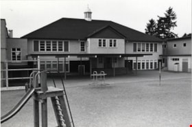
Nelson Elementary School
https://search.heritageburnaby.ca/link/archivedescription79615
- Repository
- City of Burnaby Archives
- Date
- October 9, 1976
- Collection/Fonds
- Burnaby Public Library Contemporary Visual Archive Project
- Description Level
- Item
- Physical Description
- 1 photograph : b&w ; 11 x 16 cm mounted on cardboard
- Scope and Content
- Photograph shows Nelson Elementary School at 4850 Irmin Street near Nelson and Rumble. The central portion of the building was constructed in 1925. In 1976 when the photograph was taken, the enrollment was 325 pupils, from kindergarten to Grade 7.
- Repository
- City of Burnaby Archives
- Date
- October 9, 1976
- Collection/Fonds
- Burnaby Public Library Contemporary Visual Archive Project
- Physical Description
- 1 photograph : b&w ; 11 x 16 cm mounted on cardboard
- Description Level
- Item
- Record No.
- 556-356
- Access Restriction
- No restrictions
- Reproduction Restriction
- Reproduce for fair dealing purposes only
- Accession Number
- 2013-13
- Scope and Content
- Photograph shows Nelson Elementary School at 4850 Irmin Street near Nelson and Rumble. The central portion of the building was constructed in 1925. In 1976 when the photograph was taken, the enrollment was 325 pupils, from kindergarten to Grade 7.
- Subjects
- Buildings - Schools
- Names
- Nelson Avenue School
- Media Type
- Photograph
- Photographer
- McCarron, John
- Notes
- Scope note taken directly from BPL photograph description.
- 1 b&w copy negative : 10 x 12.5 cm accompanying
- Geographic Access
- Irmin Street
- Street Address
- 4850 Irmin Street
- Historic Neighbourhood
- Alta-Vista (Historic Neighbourhood)
- Planning Study Area
- Sussex-Nelson Area
Images

Seaforth Elementary School
https://search.heritageburnaby.ca/link/archivedescription79621
- Repository
- City of Burnaby Archives
- Date
- September 22, 1976
- Collection/Fonds
- Burnaby Public Library Contemporary Visual Archive Project
- Description Level
- Item
- Physical Description
- 1 photograph : b&w ; 11 x 16 cm mounted on cardboard
- Scope and Content
- Photograph shows bicycles parked outside Seaforth Elementary School 7881 Government Street near Piper Avenue. The older part of the school was constructed in 1922, newer portions contructed 1953-1958.
- Repository
- City of Burnaby Archives
- Date
- September 22, 1976
- Collection/Fonds
- Burnaby Public Library Contemporary Visual Archive Project
- Physical Description
- 1 photograph : b&w ; 11 x 16 cm mounted on cardboard
- Description Level
- Item
- Record No.
- 556-361
- Access Restriction
- No restrictions
- Reproduction Restriction
- Reproduce for fair dealing purposes only
- Accession Number
- 2013-13
- Scope and Content
- Photograph shows bicycles parked outside Seaforth Elementary School 7881 Government Street near Piper Avenue. The older part of the school was constructed in 1922, newer portions contructed 1953-1958.
- Names
- Seaforth School
- Media Type
- Photograph
- Photographer
- McCarron, John
- Notes
- Scope note taken directly from BPL photograph description.
- 1 b&w copy negative : 10 x 12.5 cm accompanying
- Geographic Access
- Government Road
- Street Address
- 7881 Government Road
- Historic Neighbourhood
- Lozells (Historic Neighbourhood)
- Planning Study Area
- Government Road Area
Images
